

Earthquakes in the Canberra Region - Geoscience Australia
Earthquakes in the Canberra Region - Geoscience Australia
Earthquakes in the Canberra Region - Geoscience Australia
- No tags were found...

You also want an ePaper? Increase the reach of your titles
YUMPU automatically turns print PDFs into web optimized ePapers that Google loves.
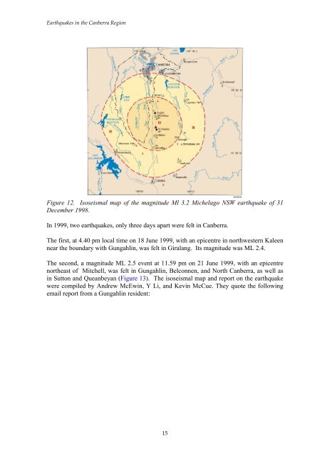
<strong>Earthquakes</strong> <strong>in</strong> <strong>the</strong> <strong>Canberra</strong> <strong>Region</strong>Figure 12. Isoseismal map of <strong>the</strong> magnitude Ml 3.2 Michelago NSW earthquake of 31December 1998.In 1999, two earthquakes, only three days apart were felt <strong>in</strong> <strong>Canberra</strong>.The first, at 4.40 pm local time on 18 June 1999, with an epicentre <strong>in</strong> northwestern Kaleennear <strong>the</strong> boundary with Gungahl<strong>in</strong>, was felt <strong>in</strong> Giralang. Its magnitude was ML 2.4.The second, a magnitude ML 2.5 event at 11.59 pm on 21 June 1999, with an epicentrenor<strong>the</strong>ast of Mitchell, was felt <strong>in</strong> Gungahl<strong>in</strong>, Belconnen, and North <strong>Canberra</strong>, as well as<strong>in</strong> Sutton and Queanbeyan (Figure 13). The isoseismal map and report on <strong>the</strong> earthquakewere compiled by Andrew McEw<strong>in</strong>, Y Li, and Kev<strong>in</strong> McCue. They quote <strong>the</strong> follow<strong>in</strong>gemail report from a Gungahl<strong>in</strong> resident:15


