Here - Stuff
Here - Stuff Here - Stuff
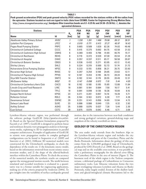
TABLE 1Peak ground acceleration (PGA) and peak ground velocity (PGV) values recorded for the stations within a 40-km radius fromthe epicenter. Stations located on rock are typed in italic (data from CESMD, Center for Engineering Strong Motion Data:http://www.strongmotioncenter.org/; bandpass filter transition bands are 0.1–0.25 Hz and 24.50–25.50 Hz). R e denotes theepicentral distance.NameStationsIdR e[km]PGAEW[g]PGANS[g]PGAUP[g]PGVEW[cm/s]PGVNS[cm/s]Heathcote Valley Primary School HVSC 1 1.230 1.261 1.466 79.96 89.12 38.51Lyttelton Port Company LPCC 4 0.919 0.771 0.413 37.27 40.97 16.43Pages Road Pumping Station PRPC 6 0.665 0.589 1.629 82.26 74.83 49.48Christchurch Cathedral College CCCC 6 0.415 0.375 0.692 64.75 43.58 21.53Christchurch Cashmere High School CMHS 6 0.369 0.403 0.796 41.69 46.79 15.17Christchurch Resthaven REHS 8 0.719 0.372 0.529 87.30 45.54 21.29Christchurch Hospital CHHC 8 0.357 0.337 0.511 65.17 56.58 20.87Christchurch Botanic Gardens CBGS 9 0.536 0.432 0.271 63.95 43.12 13.42Shirley Library SHLC 9 0.324 0.319 0.500 52.73 51.74 21.73Hulverstone Drive Pumping Station HPSC 9 0.232 0.155 0.858 36.21 26.75 33.93Riccarton High School RHSC 12 0.297 0.254 0.188 29.95 23.63 12.11Christchurch Papanui High School PPHS 12 0.187 0.243 0.195 36.73 28.24 16.82Styx Mill Transfer Station SMTC 14 0.182 0.144 0.176 28.55 20.49 12.31McQueens Valley MQZ 15 0.147 0.098 0.072 7.10 5.44 4.05Christchurch Canterbury Aero Club CACS 18 0.182 0.180 0.185 15.85 13.88 11.84Lincoln Crop and Food Research LINC 19 0.081 0.164 0.084 7.59 16.17 5.41Templeton School TPLC 19 0.091 0.099 0.136 10.36 10.09 8.16Kaiapoi North School KPOC 23 0.211 0.201 0.057 14.19 19.39 5.71Rolleston School ROLC 26 0.164 0.163 0.072 6.30 7.77 4.28Swannanoa School SWNC 29 0.251 0.143 0.056 14.69 13.94 4.73Selwyn Lake Road SLRC 33 0.086 0.088 0.049 7.25 8.32 2.92Ashley School ASHS 35 0.088 0.076 0.037 7.28 5.44 2.30Cust School CSTC 39 0.075 0.078 0.042 6.46 6.71 3.09PGVUP[cm/s]Lyttelton-Akaroa volcanic region, was performed throughthe software package GeoELSE (http://geoelse.stru.polimi.it). Based on the Spectral Element formulation proposed byFaccioli et al. (1997), GeoELSE is designed to perform linearand nonlinear dynamic wave propagation analyses in heterogeneousmedia, exploiting in 3D its implementation in parallelcomputer architectures. Examples of application of GeoELSEto seismic wave propagation studies in complex geologicalconfigurations can be found in Stupazzini et al. (2009) andSmerzini et al. (2011). Different 3D numerical models wereconstructed for the Christchurch earthquake, to check thedependence of the results on: 1) the kinematic source model,based on the information retrieved from recent seismic sourceinversion studies, and 2) the shape of the alluvial-bedrockinterface within the Canterbury Plains. To check the accuracyof the numerical models, the synthetic results are comparedagainst the strong ground motion records. The misfit betweensimulated and recorded waveforms is evaluated in a quantitativeway in a format suitable for engineering applications,making use of the criteria proposed by Anderson (2004). Togive insights into the variability of surface earthquake groundmotion, due to the interaction between near-fault conditionsand strong geological variations, ground-shaking maps andsnapshots of the velocity wavefield are shown.GEOLOGY OF THE CHRISTCHURCH REGIONThe area under study extends from the Southern Alps tothe Lyttelton-Akaroa volcanic region and includes the cityof Christchurch and parts of the Canterbury Plains and theBanks Peninsula. Information about the geology of this areacomes from the 1:250,000 geological map of Christchurch,produced by GNS (Forsyth et al. 2008). Based on the geologicalmap and on the available cross-sections, it was possible toinfer a preliminary stratigraphy for the alluvial cover fillingthe Canterbury Plains in the area of interest (Figure 1). Thebasement rock of the whole region is the Torlesse compositeterrane, a deformed package of Carboniferous to Cretaceoussedimentary rocks. Late Miocene volcanism forms the twomajor overlapping volcanoes Lyttelton and Akaroa on BanksPeninsula, today largely eroded. Erosion of the shallow landmassand glacial-interglacial climatic fluctuations led to the768 Seismological Research Letters Volume 82, Number 6 November/December 2011
▲ ▲ Figure 1. A) Area of the model under study, including part of the Canterbury Plains and the Lyttelton-Akaroa volcanic region, alongwith the strong ground motion stations. B) Geological A-A’ cross-section.widespread decomposition of unconsolidated Quaternarysediments that constitute the Canterbury Plains. The alluvialsequence is formed by coal, clay, limestone, and sand (Forsythet al. 2008).It is possible to consider the deep crustal model as basinsediments overlying a layer of Torlesse graywacke down toaround 5 km, overlying, in turn, a layer of Haast Schist downto around 20 km depth. The lower crust is interpreted as mafic(diorite, diabase, and gabbro) Mesozoin ocean crust (Reynersand Cowan 1993; Godfrey et al. 2001, 2002; Melhuish et al.2005). This deep crustal layer subdivision is confirmed by thehigh-resolution seismic wide-angle data, collected within theframework of the South Island Geophysical Transect (SIGHT)experiment (Kleffmann et al 1998; Mortimer et al. 2002; Longet al. 2003; Scherwarth et al. 2003).3D NUMERICAL SIMULATIONS OF THE SEISMICRESPONSE OF THE CANTERBURY PLAINS3D numerical simulations consist of the following features:1) kinematic description of the close-by seismic source, 2)horizontally layered deep geological model, 3) a simplifiedbut realistic description for the Cretaceous-Cenozoic alluvialCanterbury Plains, and 4) a linear visco-elastic soil behavior.Note that in these preliminary analyses we considereda relatively rough model for the soil behavior by assuming alinear-visco elastic constitutive law, with a quality factor Q proportionalto frequency (further details about the implementationof the visco-elastic soil behavior model can be found inStupazzini et al. 2009). Different 3D numerical models werebuilt for the Christchurch earthquake to achieve the best fitwith the ground motion observations, combining: 1) two differentkinematic seismic fault solutions, based on recent seismicsource inversion studies, and 2) two simplified models for theshape that defines the interface between the alluvial soft soilsediments and the rigid volcano materials. The 3D model ofthe region of the South Island of New Zealand covers an area ofapproximately 60 x 60 x 20 km around the city of Christchurch,including the information available in the geological map andthe 2D cross-sections, shown in Figure 1 and described in theprevious section.Two different models were constructed to approximatethe complex geological configuration of the Canterbury Plains.The models, referred to hereafter as “step-like” and “smooth,”basically differ in the transition between the alluvial soft sedimentsand the rigid volcano materials, as sketched in Figure 2.In the “step-like” model (Figure 2A), a rough approximationof the alluvial-bedrock shape is adopted. More specifically, thethickness of the alluvial basin is assumed constant across thewhole area under study and equal to 1.5 km. In the “smooth”model, the shape of the interface between the soft soil and thevolcanic materials is improved, with constraints inferred fromthe topography of the volcano (Figure 2B). For both models,the alluvial basin consists of three different layers with V Sranging from 300 m/s in the top 300 m to 1,500 m/s at theinterface with the volcanic materials (top three layers of TableSeismological Research Letters Volume 82, Number 6 November/December 2011 769
- Page 1: Volume 82, Number 6 November/Decemb
- Page 7: News and Notes (continued)Nominatio
- Page 11: Preface to the Focused Issue on the
- Page 16 and 17: ▲▲Figure 2. A) Sketch of the
- Page 18 and 19: ▲▲Figure 4. A) Adopted moment r
- Page 20 and 21: ▲▲Figure 7. As in Figure 6 but
- Page 22 and 23: ▲ ▲ Figure 8. Misfit parameters
- Page 24 and 25: ▲ ▲ Figure 10. Spatial variabil
- Page 26 and 27: ▲ ▲ Figure 12. Standard spectra
- Page 28 and 29: Quigley, M., R. Van Dissen, P. Vill
- Page 30 and 31: slip on a 59-degree striking fault
- Page 32 and 33: ▲▲Figure 4. Convergence of inve
- Page 34 and 35: observations and other source studi
- Page 36 and 37: -42. 5-43. 0-43. 5-44. 0-44. 5-43.2
- Page 38 and 39: “Product CSK © ASI, (ItalianSpac
- Page 40 and 41: TABLE 2Solutions for fault location
- Page 42 and 43: -43.45(A)degrees N-43.50-43.552.52.
- Page 44 and 45: is still a good fit to the horizont
- Page 46 and 47: Coulomb Stress Change Sensitivity d
- Page 48 and 49: mation takes on a larger strike-sli
- Page 50 and 51: P 9.4267BLDU45P 20.1213CASY39P 2.62
- Page 52 and 53: ERMJNUMAJOINUJHJ2CBIJMIDWJOWYHNBTPU
- Page 54 and 55: (A)6.146.13(B)6.246.36Misfit6.156.1
- Page 56 and 57: (A)(B)(C)(D)▲▲Figure 10. The co
- Page 58 and 59: (A)(B)(C)(D)▲▲Figure 12. The co
- Page 60 and 61: Luo, Y., Y. Tan, S. Wei, D. Helmber
- Page 62 and 63: −44˚00' −43˚00'4-Sep-2010Mw 7
TABLE 1Peak ground acceleration (PGA) and peak ground velocity (PGV) values recorded for the stations within a 40-km radius fromthe epicenter. Stations located on rock are typed in italic (data from CESMD, Center for Engineering Strong Motion Data:http://www.strongmotioncenter.org/; bandpass filter transition bands are 0.1–0.25 Hz and 24.50–25.50 Hz). R e denotes theepicentral distance.NameStationsIdR e[km]PGAEW[g]PGANS[g]PGAUP[g]PGVEW[cm/s]PGVNS[cm/s]Heathcote Valley Primary School HVSC 1 1.230 1.261 1.466 79.96 89.12 38.51Lyttelton Port Company LPCC 4 0.919 0.771 0.413 37.27 40.97 16.43Pages Road Pumping Station PRPC 6 0.665 0.589 1.629 82.26 74.83 49.48Christchurch Cathedral College CCCC 6 0.415 0.375 0.692 64.75 43.58 21.53Christchurch Cashmere High School CMHS 6 0.369 0.403 0.796 41.69 46.79 15.17Christchurch Resthaven REHS 8 0.719 0.372 0.529 87.30 45.54 21.29Christchurch Hospital CHHC 8 0.357 0.337 0.511 65.17 56.58 20.87Christchurch Botanic Gardens CBGS 9 0.536 0.432 0.271 63.95 43.12 13.42Shirley Library SHLC 9 0.324 0.319 0.500 52.73 51.74 21.73Hulverstone Drive Pumping Station HPSC 9 0.232 0.155 0.858 36.21 26.75 33.93Riccarton High School RHSC 12 0.297 0.254 0.188 29.95 23.63 12.11Christchurch Papanui High School PPHS 12 0.187 0.243 0.195 36.73 28.24 16.82Styx Mill Transfer Station SMTC 14 0.182 0.144 0.176 28.55 20.49 12.31McQueens Valley MQZ 15 0.147 0.098 0.072 7.10 5.44 4.05Christchurch Canterbury Aero Club CACS 18 0.182 0.180 0.185 15.85 13.88 11.84Lincoln Crop and Food Research LINC 19 0.081 0.164 0.084 7.59 16.17 5.41Templeton School TPLC 19 0.091 0.099 0.136 10.36 10.09 8.16Kaiapoi North School KPOC 23 0.211 0.201 0.057 14.19 19.39 5.71Rolleston School ROLC 26 0.164 0.163 0.072 6.30 7.77 4.28Swannanoa School SWNC 29 0.251 0.143 0.056 14.69 13.94 4.73Selwyn Lake Road SLRC 33 0.086 0.088 0.049 7.25 8.32 2.92Ashley School ASHS 35 0.088 0.076 0.037 7.28 5.44 2.30Cust School CSTC 39 0.075 0.078 0.042 6.46 6.71 3.09PGVUP[cm/s]Lyttelton-Akaroa volcanic region, was performed throughthe software package GeoELSE (http://geoelse.stru.polimi.it). Based on the Spectral Element formulation proposed byFaccioli et al. (1997), GeoELSE is designed to perform linearand nonlinear dynamic wave propagation analyses in heterogeneousmedia, exploiting in 3D its implementation in parallelcomputer architectures. Examples of application of GeoELSEto seismic wave propagation studies in complex geologicalconfigurations can be found in Stupazzini et al. (2009) andSmerzini et al. (2011). Different 3D numerical models wereconstructed for the Christchurch earthquake, to check thedependence of the results on: 1) the kinematic source model,based on the information retrieved from recent seismic sourceinversion studies, and 2) the shape of the alluvial-bedrockinterface within the Canterbury Plains. To check the accuracyof the numerical models, the synthetic results are comparedagainst the strong ground motion records. The misfit betweensimulated and recorded waveforms is evaluated in a quantitativeway in a format suitable for engineering applications,making use of the criteria proposed by Anderson (2004). Togive insights into the variability of surface earthquake groundmotion, due to the interaction between near-fault conditionsand strong geological variations, ground-shaking maps andsnapshots of the velocity wavefield are shown.GEOLOGY OF THE CHRISTCHURCH REGIONThe area under study extends from the Southern Alps tothe Lyttelton-Akaroa volcanic region and includes the cityof Christchurch and parts of the Canterbury Plains and theBanks Peninsula. Information about the geology of this areacomes from the 1:250,000 geological map of Christchurch,produced by GNS (Forsyth et al. 2008). Based on the geologicalmap and on the available cross-sections, it was possible toinfer a preliminary stratigraphy for the alluvial cover fillingthe Canterbury Plains in the area of interest (Figure 1). Thebasement rock of the whole region is the Torlesse compositeterrane, a deformed package of Carboniferous to Cretaceoussedimentary rocks. Late Miocene volcanism forms the twomajor overlapping volcanoes Lyttelton and Akaroa on BanksPeninsula, today largely eroded. Erosion of the shallow landmassand glacial-interglacial climatic fluctuations led to the768 Seismological Research Letters Volume 82, Number 6 November/December 2011


