dublin, ireland eidw/dub dublin, ireland eidw/dub - German Flight ...
dublin, ireland eidw/dub dublin, ireland eidw/dub - German Flight ...
dublin, ireland eidw/dub dublin, ireland eidw/dub - German Flight ...
- No tags were found...

Create successful ePaper yourself
Turn your PDF publications into a flip-book with our unique Google optimized e-Paper software.
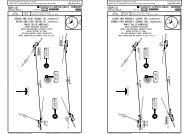
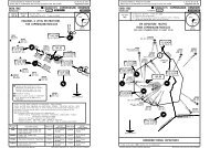
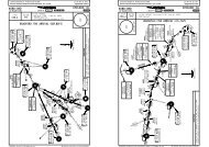
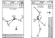
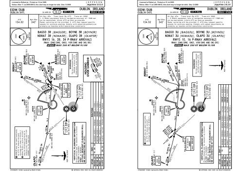
Licensed to Elefant air. Printed on 15 Jul 2009.Notice: After 17 Jul 2009 0901Z, this chart may no longer be valid. Disc 13-2009EIDW/DUBDUBLIN INTLATIS124.52Apt Elev242'24 APR 09JEPPESEN10-2.Eff.7.May.JEPPESENJeppView 3.6.3.0DUBLIN, IRELAND.RNAV.STAR.Alt Set: hPa Trans level: By ATC Trans alt: 5000'1. If RNAV equipment fails or navigation accuracy of +1NM cannot be maintained, inform ATC as soon as possible.Radar vectoring will be provided. 2. ATC may request specificspeeds for accurate spacing. Comply with speed adjustments aspromptly as feasible within operational constraints.BAGSO 3R [BAGS3R], BOYNE 3R [BOYN3R]NIMAT 3R [NIMA3R], OLAPO 3R [OLAP3R]RWYS 16, 28, 34 P-RNAV ARRIVALS335^DUBR070^DUB040^D34.5063^ASKUPN53 53.6 W006 06.5(DUB R-021/D24.7)ERUDAN53 40.5 W006 16.9(DUB R-010/D10.6)EI(D)-1ROKNAN53 39.4 W005 53.0NIMATN53 57.9 W005 44.5BOYNEN53 46.0 W005 30.0BAGSON53 40.8 W005 30.0269^15.2249^13.7BOYNE 3R19.2NIMAT 3R200^099^D22.8322^100^16.3 14.3ULTAGN53 42.0 W006 44.3D39.1 301^ DUB108^OLAPO 3R20.41OLAPON53 46.8 W007 17.7DUBLIND114.9 DUBN53 30.0 W006 18.4250 KTMAX1At or aboveMAX6000'220 KTCOLLINSTOWND111.2 DAPN53 25.4 W006 18.2250 KTMAX(DUB R-065/D33)250 KTMAX(DUB R-074/D30.8)250 KTMAXBAGSO3R22GIMRON53 39.2W005 44.9(DUB R-070/D22)HOLDINGOVER GIMRO2MSADUB VORRNAV (DME/DME, GNSS, VOR/DME AND INS/IRS)051^MAX 250 KT BELOW FL100D22D17.9/23D17.9NOT TO SCALEVERTICAL PLANNING INFORMATIONPilots should plan for descent as follows:FL100 by BAGSO;6000' by ROKNA.ACTUAL DESCENT CLEARANCE WILLBE AS DIRECTED BY ATC.STAR RWYROUTINGBAGSO 3R 16, 28, 34 BAGSO (K250-) - ROKNA (6000'+; K220-).BOYNE 3RBOYNE (K250-) - ROKNA (6000'+; K220-).NIMAT 3RNIMAT (K250-) - ROKNA (6000'+; K220-).OLAPO 3R 28, 34 OLAPO - ULTAG - ERUDA (K250-) - ROKNA(6000'+; K220-).WARNINGDo not proceed beyondROKNA without ATCclearance, enter holding.2200'4000'SPEED:By ATCMAX FL140MAX 220 KT250^MHA 5000D22/26MHA 5000MAX FL140MAX 220 KT243^ASKUP may be used tacticallyby ATC to ensure aircraftroutings are clear of EI(D)-1.When EI(D)-1 active aircraftmay be directed/vectored toholding over GIMRO and fromGIMRO to the approach.CHANGES:STARs replaced by RNAV STARs.| JEPPESEN, 2002, 2009. ALL RIGHTS RESERVED.Licensed to Elefant air. Printed on 15 Jul 2009.Notice: After 17 Jul 2009 0901Z, this chart may no longer be valid. Disc 13-2009EIDW/DUBDUBLIN INTLATIS124.52Apt Elev242'24 APR 09JEPPESEN10-2A .Eff.7.May.JEPPESENJeppView 3.6.3.0DUBLIN, IRELAND.RNAV.STAR.Alt Set: hPa Trans level: By ATC Trans alt: 5000'1. If RNAV equipment fails or navigation accuracy of +1NM cannot be maintained, inform ATC as soon as possible.Radar vectoring will be provided. 2. ATC may request specificspeeds for accurate spacing. Comply with speed adjustments aspromptly as feasible within operational constraints.BAGSO 3U [BAGS3U], BOYNE 3U [BOYN3U]NIMAT 3U [NIMA3U], OLAPO 3U [OLAP3U]RWYS 10, 16 P-RNAV ARRIVALS335^DUB040^D34.5ASKUPN53 53.6 W006 06.5(DUB R-021/D24.7)ERUDAN53 40.5 W006 16.9(DUB R-010/D10.6)EI(D)-1NIMATN53 57.9 W005 44.5BOYNEN53 46.0 W005 30.0BAGSON53 40.8 W005 30.0269^15.2249^13.7BAGSO 3UBOYNE 3U19.2NIMAT 3U200^16.3 14.3280^279^D22.8322^ULTAGN53 42.0 W006 44.3D39.1 301^ DUB108^OLAPO 3U20.4OLAPON53 46.8 W007 17.7250 KTMAXAt or aboveMAX16000'220 KT250 KTMAX1ROKNAN53 39.4W005 53.0(DUB R-063/D17.9)DUBLIND114.9 DUBN53 30.0 W006 18.4COLLINSTOWND111.2 DAPN53 25.4 W006 18.2NOT TO SCALE(DUB R-065/D33)(DUB R-074/D30.8)2200'4000'MSADUB VORRNAV (DME/DME, GNSS, VOR/DME AND INS/IRS)051^SPEED:MAX 250 KT BELOW FL100STAR RWYROUTING10BAGSO - ROKNA - ERUDA (K250-) - ULTAG (6000'+; K220-).BOYNE - ROKNA - ERUDA (K250-) - ULTAG (6000'+; K220-).NIMAT - ROKNA - ERUDA (K250-) - ULTAG (6000'+; K220-).142^MHA 5000MAX FL140MAX 220 KTD22.8/28BAGSO 3UBOYNE 3UNIMAT 3UOLAPO 3U10, 16ASKUP may be used tacticallyby ATC to ensure aircraftroutings are clear of EI(D)-1.VERTICAL PLANNING INFORMATIONPilots should plan for descent as follows:FL160 by BAGSO;6000' by ULTAG.ACTUAL DESCENT CLEARANCE WILLBE AS DIRECTED BY ATC.OLAPO (K250-) - ULTAG (6000'+; K220-).WARNINGDo not proceed beyondULTAG without ATCclearance, enter holding.CHANGES:STARs replaced by RNAV STARs.| JEPPESEN, 2002, 2009. ALL RIGHTS RESERVED.
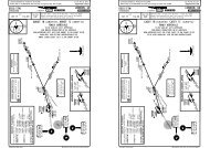
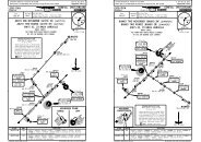
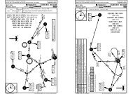
Licensed to Elefant air. Printed on 15 Jul 2009.Notice: After 17 Jul 2009 0901Z, this chart may no longer be valid. Disc 13-2009EIDW/DUBDUBLIN INTLATIS124.52NASRIN53 19.1 W006 35.3At or aboveMAXMHA 50006000'220 KTApt Elev242'D14.8 R228^BALDONNELD115.8 BAL17.6N53 18.0 W006 26.929 MAY 09JEPPESEN10-2BTULSON53 12.0 W005 50.1(BAL R-110/D22.9)JEPPESENJeppView 3.6.3.0DUBLIN, IRELAND.RNAV.STAR.Alt Set: hPa Trans level: By ATC Trans alt: 5000'1. If RNAV equipment fails or navigation accuracy of +1NM cannot be maintained, inform ATC as soon as possible.Radar vectoring will be provided. 2. ATC may request specificspeeds for accurate spacing. Comply with speed adjustments aspromptly as feasible within operational constraints.LIPGO 3N [LIPG3N], LIPGO 3T [LIPG3T]VATRY 3N [VATR3N], VATRY 3TRWYS 10, 28, 34 P-RNAV ARRIVALSMAX FL140MAX 220 KT048^D14.8/20RNAV (DME/DME, GNSS, VOR/DME AND INS/IRS)SPEED: MAX 250 KT BELOW FL100285^DUBLIND114.9 DUBN53 30.0 W006 18.4KILLINEYKLY 378 N53 16.2 W006 06.410.6LIPGO 3NVATRY 3NWARNINGDo not proceed beyond NASRI(RWY 10)/TULSO (RWYs 28, 34)without ATC clearance, enter holding.MAX250 KT298^[VATR3T]LIPGO 3N, 3T14.6LIPGO 3TVATRY 3TAt or aboveMAX6000'220 KT309^051^2200'4000'335^MSADUB VORLIPGON53 03.8 W005 30.0(DUB R-136/D39.1)Licensed to Elefant air. Printed on 15 Jul 2009.Notice: After 17 Jul 2009 0901Z, this chart may no longer be valid. Disc 13-2009EIDW/DUBDUBLIN INTLATIS124.52ULTAGN53 42.0 W006 44.3At or aboveMAX6000'220 KT6.1D22.8BALDONNELD115.8 BALN53 18.0 W006 26.9Apt Elev242'DWN27N53 37.6 W006 37.3D16.7322^23.3OTNERN53 17.3 W006 18.5(DUB R-185/D12.7)JEPPESEN10-2CTULSON53 12.0 W005 50.1(BAL R-110/D22.9)JEPPESENJeppView 3.6.3.0DUBLIN, IRELAND.RNAV.STAR.Alt Set: hPa Trans level: By ATC Trans alt: 5000'1. If RNAV equipment fails or navigation accuracy of +1NM cannot be maintained, inform ATC as soon as possible.Radar vectoring will be provided. 2. ATC may request specificspeeds for accurate spacing. Comply with speed adjustments aspromptly as feasible within operational constraints.336^MAX250 KT29 MAY 09LIPGO 3U [LIPG3U]VATRY 3U [VATR3U]RWY 16 P-RNAV ARRIVALSRNAV (DME/DME, GNSS, VOR/DME AND INS/IRS)SPEED: MAX 250 KT BELOW FL1007.3283^DUBLIND114.9 DUBN53 30.0 W006 18.4DAP111.2 DAPD COLLINSTOWNN53 25.4 W006 18.210.6KILLINEYKLY 378 N53 16.2 W006 06.4298^14.6LIPGO 3UHOLDINGOVER ULTAG142^309^051^2200'4000'335^MSADUB VORD22.8/28MHA 5000MAX FL140MAX 220 KTDAP322^D22.8VERTICAL PLANNING INFORMATIONPilots should plan for descent as follows:6000' by NASRI (RWY 10);6000' by TULSO (RWYs 28, 34).ACTUAL DESCENT CLEARANCE WILLBE AS DIRECTED BY ATC.40.6LIPGON53 03.8W005 30.0(DUB R-136/D39.1)HOLDINGOVER TULSOBALD22.9R110^RWYs 28, 34By ATCMHA 5000MAX FL140MAX 220 KTD22.9/28290^NOT TO SCALEVATRY 3N, 3TDUB157^D63.9347^VATRYN52 33.3 W005 30.0NOT TO SCALEWARNINGDo not proceed beyondULTAG without ATCclearance, enter holding.VERTICAL PLANNING INFORMATIONPilots should plan for descent as follows:6000' by ULTAG.ACTUAL DESCENT CLEARANCE WILLBE AS DIRECTED BY ATC.DUBVATRY 3U40.6 347^157^D63.9STARLIPGO 3NLIPGO 3TVATRY 3NVATRY 3TCHANGES: None.RWYROUTING10 LIPGO - TULSO - KLY (K250-) - NASRI (6000'+; K220-).28, 34 LIPGO - TULSO (6000'+; K220-).10 VATRY - TULSO - KLY (K250-) - NASRI (6000'+; K220-).28, 34 VATRY - TULSO (6000'+; K220-).| JEPPESEN, 2004, 2009. ALL RIGHTS RESERVED.STARLIPGO 3UVATRY 3UCHANGES: Bearing from KLY to OTNER.ROUTINGLIPGO - TULSO - KLY - OTNER (K250-) - DWN27 - ULTAGVATRY - TULSO - KLY - OTNER (K250-) - DWN27 - ULTAGVATRYN52 33.3W005 30.0(6000'+; K220-).(6000'+; K220-).| JEPPESEN, 2004, 2009. ALL RIGHTS RESERVED.
Licensed to Elefant air. Printed on 15 Jul 2009.Notice: After 17 Jul 2009 0901Z, this chart may no longer be valid. Disc 13-2009EIDW/DUBDUBLIN INTLATIS124.52Apt Elev242'24 APR 09JEPPESEN10-2D .Eff.7.May.JEPPESENJeppView 3.6.3.0DUBLIN, IRELAND.RNAV.STAR.Alt Set: hPa Trans level: By ATC Trans alt: 5000'1. If RNAV equipment fails or navigation accuracy of +1NM cannot be maintained, inform ATC as soon as possible.Radar vectoring will be provided. 2. ATC may request specificspeeds for accurate spacing. Comply with speed adjustments aspromptly as feasible within operational constraints.BUNED 3N [BUNE3N], BUNED 3T [BUNE3T]OSGAR 3N [OSGA3N], OSGAR 3T [OSGA3T]SUTEX 3N [SUTE3N], SUTEX 3T [SUTE3T]RWYS 10, 28, 34 P-RNAV ARRIVALSRNAV (DME/DME, GNSS, VOR/DME AND INS/IRS)SPEED: MAX 250 KT BELOW FL100051^2200'4000'335^MSADUB VORLicensed to Elefant air. Printed on 15 Jul 2009.Notice: After 17 Jul 2009 0901Z, this chart may no longer be valid. Disc 13-2009EIDW/DUBDUBLIN INTLATIS124.52Apt Elev242'24 APR 09JEPPESEN10-2E .Eff.7.May.JEPPESENJeppView 3.6.3.0DUBLIN, IRELAND.RNAV.STAR.Alt Set: hPa Trans level: By ATC Trans alt: 5000'1. If RNAV equipment fails or navigation accuracy of +1NM cannot be maintained, inform ATC as soon as possible.Radar vectoring will be provided. 2. ATC may request specificspeeds for accurate spacing. Comply with speed adjustments aspromptly as feasible within operational constraints.BUNED 3U [BUNE3U], OSGAR 3U [OSGA3U]SUTEX 3U [SUTE3U]RWY 16 P-RNAV ARRIVALSRNAV (DME/DME, GNSS, VOR/DME AND INS/IRS)SPEED: MAX 250 KT BELOW FL100142^051^2200'4000'335^MSADUB VORHOLDINGOVER TULSOBALD22.9R110^OSGARN53 03.0W007 16.2MHA 5000MAX FL140MAX 220 KTD44 237^102^By ATCD22.9/28290^DUB22.2OSGAR 3N, 3T047^CHANGES: STARs replaced by RNAV STARs.D46.4 214^NASRIN53 19.1 W006 35.3DUBBUNED 3NOSGAR 3NSUTEX 3N19.214.5At or aboveMAXMHA 5000013^SUTEX3N, 3T6000'220 KTMAX FL140MAX 220 KT048^D14.8/20BUNED 3N, 3T002^D32.5 208^22.9D54 197^ DUBDUB051^D14.8 R228^19.47.8130^BUNED 3TOSGAR 3TSUTEX 3TDIRUMN53 00.2 W006 39.7BUNED 3NOSGAR 3NSUTEX 3NMAX250 KTBALDONNELD115.8 BALN53 18.0 W006 26.9100^15.8110^ELKAMN53 13.5 W006 16.3MAX250 KTDUBLIND114.9 DUBN53 30.0 W006 18.4MAXD22.9TULSON53 12.0W005 50.1At or above6000'220 KTVERTICAL PLANNINGSUTEXN52 49.5INFORMATIONNOT TO SCALE W006 55.8Pilots should plan for descent asfollows:6000' by NASRI (RWY 10);WARNING6000' by TULSO (RWYs 28, 34).Do not proceed beyond NASRIACTUAL DESCENT CLEARANCE(RWY 10)/TULSO (RWYs 28, 34)WILL BE AS DIRECTED BY ATC.without ATC clearance, enter holding.BUNEDN52 37.4 W006 37.8STAR RWYROUTINGBUNED 3N 10 BUNED - DIRUM (K250-) - NASRI (6000'+; K220-).BUNED 3T 28, 34 BUNED - DIRUM - ELKAM (K250-) - TULSO (6000'+; K220-).OSGAR 3N 10 OSGAR - DIRUM (K250-) - NASRI (6000'+; K220-).OSGAR 3T 1 28, 34 OSGAR - DIRUM - ELKAM (K250-) - TULSO (6000'+; K220-).SUTEX 3N 10 SUTEX - DIRUM (K250-) - NASRI (6000'+; K220-).SUTEX 3T 28, 34 SUTEX - DIRUM - ELKAM (K250-) - TULSO (6000'+; K220-).1 Available when military not active.| JEPPESEN, 2004, 2009. ALL RIGHTS RESERVED.OSGARN53 03.0W007 16.2NOT TO SCALED44102^ULTAGN53 42.0 W006 44.3237^MAXD22.8/28At or aboveSUTEXN52 49.5 W006 55.86000'220 KTDUB22.2MHA 5000MAX FL140MAX 220 KTOSGAR 3UD46.4047^CHANGES: STARs replaced by RNAV STARs.214^DUB6.1D22.8BALDONNELD115.8 BALN53 18.0 W006 26.914.5D32.5SUTEX3UBUNED 3U002^208^197^D54DWN27N53 37.6 W006 37.3D16.7DUB322^DUB23.3164^D8.3336^DIRUMN53 00.2 W006 39.722.9051^14.77.3022^BUNEDN52 37.4 W006 37.8KEPORN53 10.3 W006 22.0DUBLIND114.9 DUBN53 30.0 W006 18.4DAP111.2 DAPD COLLINSTOWNN53 25.4 W006 18.2OTNERN53 17.3 W006 18.5(DUB R-185/D12.7)MAX250 KTWARNINGDo not proceed beyondULTAG without ATCclearance, enter holding.VERTICAL PLANNINGINFORMATIONPilots should plan fordescent as follows:6000' by ULTAG.ACTUAL DESCENTCLEARANCE WILL BEAS DIRECTED BY ATC.STARROUTINGBUNED 3U BUNED - DIRUM - KEPOR - OTNER (K250-) - DWN27 - ULTAG (6000'+; K220-).OSGAR 3U OSGAR - DIRUM - KEPOR - OTNER (K250-) - DWN27 - ULTAG (6000'+; K220-).SUTEX 3U SUTEX - DIRUM - KEPOR - OTNER (K250-) - DWN27 - ULTAG (6000'+; K220-).| JEPPESEN, 2004, 2009. ALL RIGHTS RESERVED.
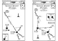
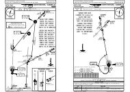
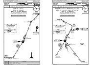
Licensed to Elefant air. Printed on 15 Jul 2009.Notice: After 17 Jul 2009 0901Z, this chart may no longer be valid. Disc 13-2009EIDW/DUBDUBLIN INTLCHANGES: SIDs replaced by RNAV SIDs.JEPPESENRNAV SID DESIGNATIONBEPAN 4A, 4EBEPAN 4G, 4MINKUR 4A, 4EINKUR 4G, 4MLIFFY 4A, 4ELIFFY 4G, 4MNEVRI 4A, 4ENEVRI 4G, 4MOLONO 4A, 4EOLONO 4G, 4MPELIG 4APELIG 4G, 4MPESIT 4A, 4EPESIT 4G, 4MROTEV 4A, 4EROTEV 4G, 4MSUROX 4A, 4ESUROX 4G, 4MBAMLI 4B, 4FBAMLI 4H, 4PBEPAN 4B, 4FBEPAN 4H, 4PINKUR 4B, 4FINKUR 4H, 4PLIFFY 4B, 4FLIFFY 4H, 4PNEVRI 4B, 4FNEVRI 4H, 4POLONO 4B, 4FOLONO 4H, 4PPELIG 4HPESIT 4B, 4FPESIT 4H, 4PROTEV 4B, 4FROTEV 4H, 4PSUROX 4B, 4FSUROX 4H, 4PJEPPESENJeppView 3.6.3.0DUBLIN, IRELAND24 APR 09 10-3 .Eff.7.May..RNAV.SID.REFER TO CHART10-3A10-3B10-3C10-3D10-3E10-3F10-3G10-3H10-3J10-3K10-3L10-3M10-3N10-3P10-3Q10-3S10-3T10-3U10-3V10-3V110-3V210-3V310-3V410-3V510-3V610-3V710-3V810-3W10-3X10-3X110-3X210-3X310-3X410-3X510-3X610-3X710-3X8| JEPPESEN, 2004, 2009. ALL RIGHTS RESERVED.Licensed to Elefant air. Printed on 15 Jul 2009.Notice: After 17 Jul 2009 0901Z, this chart may no longer be valid. Disc 13-2009EIDW/DUBJEPPESENDUBLIN INTL 10-3A .Eff.7.May.Apt Elev242'EI(R)-15DJEPPESENJeppView 3.6.3.0DUBLIN, IRELAND24 APR 09 .RNAV.SID.Trans level: By ATC Trans alt: 5000'1. If RNAV equipment fails or navigation accuracy of +1NM can not be maintained,inform ATC as soon as possible. Radar vectoring will be provided.2. ATC may request specific speeds for accurate spacing. Comply with speed adjustmentsas promptly as feasible within operational constraints.3. Climb to MSA on initial segments of RNAV SIDs may be conducted using conventionalnavigation based on conventional navaids serving the runway in use.4. If fix data for integrity checking not available for referenced VOR/DME requestcheck fix from radar.BEPAN 4A [BEPA4A], BEPAN 4E [BEPA4E]RWYS 28, 10 P-RNAV DEPARTURESDUBLIN316 OE OEN53 25.8 W006 25.7D6.1 IDWAt or above3000'BALDONNELD115.8 BALN53 18.0 W006 26.9160^R340^CHANGES: SIDs replaced by RNAV SIDs.RNAV (DME/DME, GNSS, VOR/DME AND INS/IRS)SPEED: MAX 250 KT BELOW FL100CAT C & DDUBLIND114.9 DUBN53 30.0 W006 18.4160^WARNINGClimb to FL90.Do not climb above FL90until instructed by ATC.5280^BEPAN4AThese SIDs require a minimum climb gradientof553' per NM (9.1%).Gnd speed-KT 75 100 150 200 250 300553' per NM 691 922 1382 1843 2304 2765D23.3100^ILS DMEIDW25.65BEPAN4E(111.35) IDWN53 25.2 W006 15.319.4192^209^NEPODN52 57.0 W006 10.5BEPANN52 31.6 W006 15.8(DUB R-183/D58.5)051^DWE51N53 24.8 W006 06.7At or above3000'4000'KILLINEYKLY 378 N53 16.2 W006 06.4NOT TO SCALE2200'MSADUB VORSID RWYROUTINGBEPAN 4A128 OE (3000'+) - BAL - NEPOD - BEPAN.BEPAN 4E 10 DWE51 (3000'+) - KLY - NEPOD - BEPAN.1 Continuous climb to 4000' required for separation from military operations atin EI(R)-15. Delay acceleration phase until 4000'.3000'| JEPPESEN, 2004, 2009. ALL RIGHTS RESERVED.335^
Licensed to Elefant air. Printed on 15 Jul 2009.Notice: After 17 Jul 2009 0901Z, this chart may no longer be valid. Disc 13-2009EIDW/DUBJEPPESENDUBLIN INTL 10-3B .Eff.7.May.Apt Elev242'DWS77D5.7 IACN53 20.9 W006 10.8JEPPESENJeppView 3.6.3.0DUBLIN, IRELAND24 APR 09 .RNAV.SID.Trans level: By ATC Trans alt: 5000'1. If RNAV equipment fails or navigation accuracy of +1NM can not be maintained,inform ATC as soon as possible. Radar vectoring will be provided.2. ATC may request specific speeds for accurate spacing. Comply with speed adjustmentsas promptly as feasible within operational constraints.3. Climb to MSA on initial segments of RNAV SIDs may be conducted using conventionalnavigation based on conventional navaids serving the runway in use.4. If fix data for integrity checking not available for referenced VOR/DME requestcheck fix from radar.BEPAN 4G [BEPA4G], BEPAN 4M [BEPA4M]RWYS 34, 16 P-RNAV DEPARTURESBALDONNELD115.8 BALN53 18.0 W006 26.9RNAV (DME/DME, GNSS, VOR/DME AND INS/IRS)SPEED: MAX 250 KT BELOW FL100CAT C & DDWN26D0.9 DUBN53 30.8 W006 19.0160^BEPAN4G341^23.35155^BEPAN 4M5At or above3000'DUBLIND114.9 DUBN53 30.0 W006 18.419.45.4D192^IACILS DME(111.5) IACN53 26.0 W006 15.7At or above3000'051^4000'KILLINEYKLY 378 N53 16.2 W006 06.42200'335^MSADUB VORLicensed to Elefant air. Printed on 15 Jul 2009.Notice: After 17 Jul 2009 0901Z, this chart may no longer be valid. Disc 13-2009EIDW/DUBJEPPESENDUBLIN INTL 10-3C .Eff.7.May.Apt Elev242'INKURN53 35.9 W007 23.5DJEPPESENJeppView 3.6.3.0DUBLIN, IRELAND24 APR 09 .RNAV.SID.Trans level: By ATC Trans alt: 5000'1. If RNAV equipment fails or navigation accuracy of +1NM can not be maintained,inform ATC as soon as possible. Radar vectoring will be provided.2. ATC may request specific speeds for accurate spacing. Comply with speed adjustmentsas promptly as feasible within operational constraints.3. Climb to MSA on initial segments of RNAV SIDs may be conducted using conventionalnavigation based on conventional navaids serving the runway in use.4. If fix data for integrity checking not available for referenced VOR/DME requestcheck fix from radar.INKUR 4A [INKU4A], INKUR 4E [INKU4E]RWYS 28, 10 P-RNAV DEPARTURESRNAV (DME/DME, GNSS, VOR/DME AND INS/IRS)SPEED: MAX 250 KT BELOW FL100CAT C & DWARNINGClimb to FL90.Do not climb above FL90until instructed by ATC.39.2DUBLIN316 OE OEN53 25.8 W006 25.7D6.1 IDWAt or above3000'DDUBLIND114.9 DUBN53 30.0 W006 18.4284^5280^INKUR4AILS DMEIDW(111.35) IDWN53 25.2 W006 15.3R100^100^051^5INKUR4E4000'MSADUB VOR280^2200'335^DWE51N53 24.8 W006 06.7At or above3000'WARNINGClimb to FL90.Do not climb above FL90until instructed by ATC.NOT TO SCALEThese SIDs require a minimum climb gradientof553' per NM (9.1%).Gnd speed-KT 75 100 150 200 250 300553' per NM 691 922 1382 1843 2304 2765SIDBEPAN 4GBEPAN 4MRWY3416CHANGES: SIDs replaced by RNAV SIDs.D25.6NEPODN52 57.0 W006 10.5BEPANN52 31.6 W006 15.8(DUB R-183/D58.5)ROUTINGDWN26 (3000'+) - BAL - NEPOD - BEPAN.DWS77 (3000'+) - KLY - NEPOD - BEPAN.| JEPPESEN, 2004, 2009. ALL RIGHTS RESERVED.These SIDs require a minimum climb gradientof553' per NM (9.1%).Gnd speed-KT 75 100 150 200 250 300553' per NM 691 922 1382 1843 2304 2765SIDINKUR 4AINKUR 4ERWY2810CHANGES: SIDs replaced by RNAV SIDs.ROUTINGOE (3000'+) - INKUR.DWE51 (3000'+) - DUB - INKUR.NOT TO SCALE| JEPPESEN, 2004, 2009. ALL RIGHTS RESERVED.
Licensed to Elefant air. Printed on 15 Jul 2009.Notice: After 17 Jul 2009 0901Z, this chart may no longer be valid. Disc 13-2009EIDW/DUBJEPPESENDUBLIN INTL 10-3D .Eff.7.May.Apt Elev242'JEPPESENJeppView 3.6.3.0DUBLIN, IRELAND24 APR 09 .RNAV.SID.Trans level: By ATC Trans alt: 5000'1. If RNAV equipment fails or navigation accuracy of +1NM can not be maintained,inform ATC as soon as possible. Radar vectoring will be provided.2. ATC may request specific speeds for accurate spacing. Comply with speed adjustmentsas promptly as feasible within operational constraints.3. Climb to MSA on initial segments of RNAV SIDs may be conducted using conventionalnavigation based on conventional navaids serving the runway in use.4. If fix data for integrity checking not available for referenced VOR/DME requestcheck fix from radar.INKUR 4G [INKU4G], INKUR 4M [INKU4M]RWYS 34, 16 P-RNAV DEPARTURESRNAV (DME/DME, GNSS, VOR/DME AND INS/IRS)SPEED: MAX 250 KT BELOW FL100CAT C & D051^2200'4000'335^MSADUB VORLicensed to Elefant air. Printed on 15 Jul 2009.Notice: After 17 Jul 2009 0901Z, this chart may no longer be valid. Disc 13-2009EIDW/DUBJEPPESENDUBLIN INTL 10-3E .Eff.7.May.Apt Elev242'JEPPESENJeppView 3.6.3.0DUBLIN, IRELAND24 APR 09 .RNAV.SID.Trans level: By ATC Trans alt: 5000'1. If RNAV equipment fails or navigation accuracy of +1NM can not be maintained,inform ATC as soon as possible. Radar vectoring will be provided.2. ATC may request specific speeds for accurate spacing. Comply with speed adjustmentsas promptly as feasible within operational constraints.3. Climb to MSA on initial segments of RNAV SIDs may be conducted using conventionalnavigation based on conventional navaids serving the runway in use.4. If fix data for integrity checking not available for referenced VOR/DME requestcheck fix from radar.LIFFY 4A [LIFY4A], LIFFY 4E [LIFY4E]RWYS 28, 10 P-RNAV DEPARTURESRNAV (DME/DME, GNSS, VOR/DME AND INS/IRS)SPEED: MAX 250 KT BELOW FL100CAT C & D051^2200'4000'335^MSADUB VORINKURN53 35.9 W007 23.5D39.2 284^28.3291^NITILN53 28.0 W006 37.9WARNINGClimb to FL90.Do not climb above FL90until instructed by ATC.D12.1EI(R)-15DAP111.2 DAPD COLLINSTOWNN53 25.4 W006 18.215.9287^336^D16.4 199^DUB341^INKUR4G155^5INKUR 4M5DWN26D0.9 DUBN53 30.8 W006 19.0250^At or above3000'DUBLIND114.9 DUBN53 30.0 W006 18.4DIACILS DME(111.5) IACN53 26.0 W006 15.7DWS77D5.7 IACN53 20.9 W006 10.8At or above3000'097^5280^LIFFY4ADUBLIN316 OE OEN53 25.8 W006 25.7D6.1 IDWAt or above3000'DUBLIND114.9 DUBN53 30.0 W006 18.4R277^ 28.9D097^100^LIFFY4EILS DMEIDW5(111.35) IDWN53 25.2 W006 15.37DWE51N53 24.8 W006 06.7At or above3000'WARNINGClimb to FL90.Do not climb above FL90until instructed by ATC.077^DWE52N53 24.1 W005 55.115.8DLIFFYN53 28.8 W005 30.0DWS78N53 14.1 W006 25.1These SIDs require a minimum climb gradientof553' per NM (9.1%).Gnd speed-KT 75 100 150 200 250 300553' per NM 691 922 1382 1843 2304 2765CHANGES: SIDs replaced by RNAV SIDs.NOT TO SCALESID RWYROUTINGINKUR 4G 34 DWN26 (3000'+) - INKUR.INKUR 4M 1 16 DWS77 (3000'+) - DWS78 - NITIL - INKUR.1 Continuous climb to 4000' required for separation from military operations atin EI(R)-15. Delay acceleration phase until 4000'.3000'| JEPPESEN, 2004, 2009. ALL RIGHTS RESERVED.These SIDs require a minimum climb gradientof553' per NM (9.1%).Gnd speed-KT 75 100 150 200 250 300553' per NM 691 922 1382 1843 2304 2765SIDLIFFY 4ALIFFY 4ERWY2810CHANGES: SIDs replaced by RNAV SIDs.ROUTINGOE (3000'+) - DUB - LIFFY.DWE51 (3000'+) - DWE52 - LIFFY.NOT TO SCALE| JEPPESEN, 2004, 2009. ALL RIGHTS RESERVED.
Licensed to Elefant air. Printed on 15 Jul 2009.Notice: After 17 Jul 2009 0901Z, this chart may no longer be valid. Disc 13-2009EIDW/DUBJEPPESENDUBLIN INTL 10-3F .Eff.7.May.Apt Elev242'JEPPESENJeppView 3.6.3.0DUBLIN, IRELAND24 APR 09 .RNAV.SID.Trans level: By ATC Trans alt: 5000'1. If RNAV equipment fails or navigation accuracy of +1NM can not be maintained,inform ATC as soon as possible. Radar vectoring will be provided.2. ATC may request specific speeds for accurate spacing. Comply with speed adjustmentsas promptly as feasible within operational constraints.3. Climb to MSA on initial segments of RNAV SIDs may be conducted using conventionalnavigation based on conventional navaids serving the runway in use.4. If fix data for integrity checking not available for referenced VOR/DME requestcheck fix from radar.LIFFY 4G [LIFY4G], LIFFY 4M [LIFY4M]RWYS 34, 16 P-RNAV DEPARTURESRNAV (DME/DME, GNSS, VOR/DME AND INS/IRS)SPEED: MAX 250 KT BELOW FL100CAT C & D051^2200'4000'335^MSADUB VORLicensed to Elefant air. Printed on 15 Jul 2009.Notice: After 17 Jul 2009 0901Z, this chart may no longer be valid. Disc 13-2009EIDW/DUBJEPPESENDUBLIN INTL 10-3G .Eff.7.May.Apt Elev242'NEVRIN54 04.1 W006 16.2JEPPESENJeppView 3.6.3.0DUBLIN, IRELAND24 APR 09 .RNAV.SID.Trans level: By ATC Trans alt: 5000'1. If RNAV equipment fails or navigation accuracy of +1NM can not be maintained,inform ATC as soon as possible. Radar vectoring will be provided.2. ATC may request specific speeds for accurate spacing. Comply with speed adjustmentsas promptly as feasible within operational constraints.3. Climb to MSA on initial segments of RNAV SIDs may be conducted using conventionalnavigation based on conventional navaids serving the runway in use.4. If fix data for integrity checking not available for referenced VOR/DME requestcheck fix from radar.NEVRI 4A [NEVR4A], NEVRI 4E [NEVR4E]RWYS 28, 10 P-RNAV DEPARTURESRNAV (DME/DME, GNSS, VOR/DME AND INS/IRS)SPEED: MAX 250 KT BELOW FL100CAT C & D(DUB R-007/D34.2)051^2200'4000'335^MSADUB VORDWN26D0.9 DUBN53 30.8 W006 19.0DAt or above3000'LIFFY4GIACILS DME(111.5) IAC341^N53 26.0 W006 15.7SIDLIFFY 4GLIFFY 4M097^D7DWS77D5.7 IACN53 20.9 W006 10.8RWY3416CHANGES: SIDs replaced by RNAV SIDs.5155^LIFFY 4M5At or above3000'BATEDN53 29.7 W006 06.7DUBLIND114.9 DUBN53 30.0 W006 18.4These SIDs require a minimum climb gradientof553' per NM (9.1%).Gnd speed-KT 75 100 150 200 250 300553' per NM 691 922 1382 1843 2304 2765WARNINGClimb to FL90.Do not climb above FL90until instructed by ATC.21.9ROUTINGDWN26 (3000'+) - BATED - LIFFY.DWS77 (3000'+) - LIFFY.NOT TO SCALED28.9LIFFYN53 28.8W005 30.0| JEPPESEN, 2004, 2009. ALL RIGHTS RESERVED.SIDNEVRI 4ANEVRI 4EWARNINGClimb to FL90.Do not climb above FL90until instructed by ATC.DUBLIND114.9 DUBN53 30.0 W006 18.4DUBLIN316 OE OEN53 25.8 W006 25.7D6.1 IDWAt or above3000'RWY2810CHANGES: SIDs replaced by RNAV SIDs.5006^ 23.7010^D10.6280^NEVRI4AThese SIDs require a minimum climb gradientof553' per NM (9.1%).Gnd speed-KT 75 100 150 200 250 300553' per NM 691 922 1382 1843 2304 2765DERUDAN53 40.5 W006 16.9100^ILS DMEIDW5NEVRI4E(111.35) IDWN53 25.2 W006 15.3ROUTINGOE (3000'+) - ERUDA - NEVRI.DWE51 (3000'+) - ERUDA - NEVRI.NOT TO SCALEDWE51N53 24.8 W006 06.7At or above3000'| JEPPESEN, 2004, 2009. ALL RIGHTS RESERVED.
Licensed to Elefant air. Printed on 15 Jul 2009.Notice: After 17 Jul 2009 0901Z, this chart may no longer be valid. Disc 13-2009EIDW/DUBJEPPESENDUBLIN INTL 10-3H .Eff.7.May.Apt Elev242'NEVRIN54 04.1 W006 16.2ERUDAN53 40.5 W006 16.9(DUB R-010/D10.6)JEPPESENJeppView 3.6.3.0DUBLIN, IRELAND24 APR 09 .RNAV.SID.Trans level: By ATC Trans alt: 5000'1. If RNAV equipment fails or navigation accuracy of +1NM can not be maintained,inform ATC as soon as possible. Radar vectoring will be provided.2. ATC may request specific speeds for accurate spacing. Comply with speed adjustmentsas promptly as feasible within operational constraints.3. Climb to MSA on initial segments of RNAV SIDs may be conducted using conventionalnavigation based on conventional navaids serving the runway in use.4. If fix data for integrity checking not available for referenced VOR/DME requestcheck fix from radar.NEVRI 4G [NEVR4G], NEVRI 4M [NEVR4M]RWYS 34, 16 P-RNAV DEPARTURESRNAV (DME/DME, GNSS, VOR/DME AND INS/IRS)SPEED: MAX 250 KT BELOW FL100CAT C & DNOT TO SCALE006^ 23.7(DUB R-007/D34.2)051^WARNINGClimb to FL90.Do not climb above FL90until instructed by ATC.2200'4000'335^MSADUB VORLicensed to Elefant air. Printed on 15 Jul 2009.Notice: After 17 Jul 2009 0901Z, this chart may no longer be valid. Disc 13-2009EIDW/DUBJEPPESENDUBLIN INTL 10-3J .Eff.7.May.Apt Elev242'EI(R)-15JEPPESENJeppView 3.6.3.0DUBLIN, IRELAND24 APR 09 .RNAV.SID.Trans level: By ATC Trans alt: 5000'1. If RNAV equipment fails or navigation accuracy of +1NM can not be maintained,inform ATC as soon as possible. Radar vectoring will be provided.2. ATC may request specific speeds for accurate spacing. Comply with speed adjustmentsas promptly as feasible within operational constraints.3. Climb to MSA on initial segments of RNAV SIDs may be conducted using conventionalnavigation based on conventional navaids serving the runway in use.4. If fix data for integrity checking not available for referenced VOR/DME requestcheck fix from radar.OLONO 4A [OLON4A], OLONO 4E [OLON4E]RWYS 28, 10 P-RNAV DEPARTURESBALDONNELD115.8 BALN53 18.0 W006 26.9RNAV (DME/DME, GNSS, VOR/DME AND INS/IRS)DUBLIN316 OE OEN53 25.8 W006 25.7D6.1 IDWAt or above3000'SPEED: MAX 250 KT BELOW FL100CAT C & DDUBLIND114.9 DUBN53 30.0 W006 18.4160^R340^160^5280^OLONO4AD100^ILS DMEIDW5OLONO4E(111.35) IDWN53 25.2 W006 15.3192^209^051^DWE51N53 24.8 W006 06.7At or above3000'KILLINEYKLY 378 N53 16.2 W006 06.42200'4000'335^MSADUB VORSIDNEVRI 4GNEVRI 4MDWN26D0.9 DUBN53 30.8 W006 19.0DUBLIND114.9 DUBN53 30.0 W006 18.4CHANGES: SIDs replaced by RNAV SIDs.DAt or above3000'IACILS DME(111.5) IACNEVRI4GN53 26.0 W006 15.7RWY3416341^DWS77D5.7 IACN53 20.9 W006 10.8At or above3000'5155^NEVRI 4M097^D7511.5335^BATEDN53 29.7 W006 06.7ROUTINGDWN26 (3000'+) - ERUDA - NEVRI.DWS77 (3000'+) - BATED - ERUDA - NEVRI.344^These SIDs require a minimum climb gradientof553' per NM (9.1%).Gnd speed-KT 75 100 150 200 250 300553' per NM 691 922 1382 1843 2304 2765| JEPPESEN, 2004, 2009. ALL RIGHTS RESERVED.WARNINGClimb to FL90.Do not climb above FL90until instructed by ATC.OLONON52 43.4 W006 46.7(DUB R-205/D49.7)CHANGES: SIDs replaced by RNAV SIDs.25.823.3D243^19.4NEPODN52 57.0 W006 10.5NOT TO SCALEThese SIDs require a minimum climb gradientof553' per NM (9.1%).Gnd speed-KT 75 100 150 200 250 300553' per NM 691 922 1382 1843 2304 2765SID RWYROUTINGOLONO 4A128 OE (3000'+) - BAL - NEPOD - OLONO.OLONO 4E 10 DWE51 (3000'+) - KLY - NEPOD - OLONO.1 Continuous climb to 4000' required for separation from military operations atin EI(R)-15. Delay acceleration phase until 4000'.3000'| JEPPESEN, 2004, 2009. ALL RIGHTS RESERVED.
Licensed to Elefant air. Printed on 15 Jul 2009.Notice: After 17 Jul 2009 0901Z, this chart may no longer be valid. Disc 13-2009EIDW/DUBJEPPESENDUBLIN INTL 10-3K .Eff.7.May.Apt Elev242'JEPPESENJeppView 3.6.3.0DUBLIN, IRELAND24 APR 09 .RNAV.SID.Trans level: By ATC Trans alt: 5000'1. If RNAV equipment fails or navigation accuracy of +1NM can not be maintained,inform ATC as soon as possible. Radar vectoring will be provided.2. ATC may request specific speeds for accurate spacing. Comply with speed adjustmentsas promptly as feasible within operational constraints.3. Climb to MSA on initial segments of RNAV SIDs may be conducted using conventionalnavigation based on conventional navaids serving the runway in use.4. If fix data for integrity checking not available for referenced VOR/DME requestcheck fix from radar.OLONO 4G [OLON4G], OLONO 4M [OLON4M]RWYS 34, 16 P-RNAV DEPARTURESDWN26D0.9 DUBN53 30.8 W006 19.0BALDONNELD115.8 BALAt or above3000'N53 18.0 W006 26.9RNAV (DME/DME, GNSS, VOR/DME AND INS/IRS)SPEED: MAX 250 KT BELOW FL100CAT C & D160^OLONO4G341^5155^OLONO 4M5DUBLIND114.9 DUBN53 30.0 W006 18.45.4D192^IACILS DME(111.5) IACN53 26.0 W006 15.7DWS77D5.7 IACN53 20.9 W006 10.8At or above3000'051^4000'KILLINEYKLY 378 N53 16.2 W006 06.42200'335^MSADUB VORLicensed to Elefant air. Printed on 15 Jul 2009.Notice: After 17 Jul 2009 0901Z, this chart may no longer be valid. Disc 13-2009EIDW/DUBJEPPESENDUBLIN INTL 10-3L .Eff.7.May.Apt Elev242'JEPPESENJeppView 3.6.3.0DUBLIN, IRELAND24 APR 09 .RNAV.SID.Trans level: By ATC Trans alt: 5000'1. If RNAV equipment fails or navigation accuracy of +1NM can not be maintained,inform ATC as soon as possible. Radar vectoring will be provided.2. ATC may request specific speeds for accurate spacing. Comply with speed adjustmentsas promptly as feasible within operational constraints.3. Climb to MSA on initial segments of RNAV SIDs may be conducted using conventionalnavigation based on conventional navaids serving the runway in use.4. If fix data for integrity checking not available for referenced VOR/DME requestcheck fix from radar.PELIG 4A [PELI4A]RWY 28 P-RNAV DEPARTURERNAV (DME/DME, GNSS, VOR/DME AND INS/IRS)AVAILABLE ONLY WHEN MILITARY NOT ACTIVESPEED:MAX 250 KT BELOW FL100CAT C & DWARNINGClimb to FL90.Do not climb above FL90until instructed by ATC.DUBLIN316 OE OEN53 25.8 W006 25.7D6.1 IDWAt or above3000'DUBLIND114.9 DUBN53 30.0 W006 18.45280^051^2200'4000'335^MSADUB VOR23.319.4DILS DMEIDW(111.35) IDWN53 25.2 W006 15.3WARNINGClimb to FL90.Do not climb above FL90until instructed by ATC.NOT TO SCALEPELIGN53 12.0 W007 20.0(DUB R-249/D41.1)DSIDOLONO 4GOLONO 4MOLONON52 43.4 W006 46.7(DUB R-205/D49.7)RWY3416CHANGES: SIDs replaced by RNAV SIDs.25.8243^ROUTINGDWN26 (3000'+) - BAL - NEPOD - OLONO.DWS77 (3000'+) - KLY - NEPOD - OLONO.NEPODN52 57.0 W006 10.5These SIDs require a minimum climb gradientof553' per NM (9.1%).Gnd speed-KT 75 100 150 200 250 300553' per NM 691 922 1382 1843 2304 2765| JEPPESEN, 2004, 2009. ALL RIGHTS RESERVED.OE (3000'+) - PELIG.CHANGES: SIDs replaced by RNAV SIDs.NOT TO SCALEThis SID requires a minimum climb gradientof553' per NM (9.1%).Gnd speed-KT 75 100 150 200 250 300553' per NM 691 922 1382 1843 2304 2765ROUTING| JEPPESEN, 2004, 2009. ALL RIGHTS RESERVED.
Licensed to Elefant air. Printed on 15 Jul 2009.Notice: After 17 Jul 2009 0901Z, this chart may no longer be valid. Disc 13-2009EIDW/DUBJEPPESENDUBLIN INTL 10-3M .Eff.7.May.Apt Elev242'PELIGN53 12.0 W007 20.0(DUB R-249/D41.1)EI(R)-15JEPPESENJeppView 3.6.3.0DUBLIN, IRELAND24 APR 09 .RNAV.SID.Trans level: By ATC Trans alt: 5000'1. If RNAV equipment fails or navigation accuracy of +1NM can not be maintained,inform ATC as soon as possible. Radar vectoring will be provided.2. ATC may request specific speeds for accurate spacing. Comply with speed adjustmentsas promptly as feasible within operational constraints.3. Climb to MSA on initial segments of RNAV SIDs may be conducted using conventionalnavigation based on conventional navaids serving the runway in use.4. If fix data for integrity checking not available for referenced VOR/DME requestcheck fix from radar.PELIG 4G [PELI4G], PELIG 4M [PELI4M]RWYS 34, 16 P-RNAV DEPARTURESRNAV (DME/DME, GNSS, VOR/DME AND INS/IRS)AVAILABLE ONLY WHEN MILITARY NOT ACTIVESPEED:MAX 250 KT BELOW FL100CAT C & DWARNINGClimb to FL90.Do not climb above FL90until instructed by ATC.33.1DDWN26D0.9 DUBN53 30.8 W006 19.0DUBLIN114.9 DUBILS DMEDIACN53 30.0 W006 18.4(111.5) IACAt or above3000'PELIG4GN53 26.0 W006 15.7341^DWS77D5.7 IACN53 20.9 W006 10.8271^At or above3000'051^54000'155^PELIG 4MDWS78N53 14.1 W006 25.1(DUB R-199/D16.4)2200'335^MSADUB VOR5250^Licensed to Elefant air. Printed on 15 Jul 2009.Notice: After 17 Jul 2009 0901Z, this chart may no longer be valid. Disc 13-2009EIDW/DUBJEPPESENDUBLIN INTL 10-3N .Eff.7.May.Apt Elev242'EI(R)-15JEPPESENJeppView 3.6.3.0DUBLIN, IRELAND24 APR 09 .RNAV.SID.Trans level: By ATC Trans alt: 5000'1. If RNAV equipment fails or navigation accuracy of +1NM can not be maintained,inform ATC as soon as possible. Radar vectoring will be provided.2. ATC may request specific speeds for accurate spacing. Comply with speed adjustmentsas promptly as feasible within operational constraints.3. Climb to MSA on initial segments of RNAV SIDs may be conducted using conventionalnavigation based on conventional navaids serving the runway in use.4. If fix data for integrity checking not available for referenced VOR/DME requestcheck fix from radar.PESIT 4A [PESI4A], PESIT 4ERWYS 28, 10 P-RNAV DEPARTURESDUBLIN316 OE OEN53 25.8 W006 25.7D6.1 IDWAt or above3000'BALDONNELD115.8 BALN53 18.0 W006 26.9RNAV (DME/DME, GNSS, VOR/DME AND INS/IRS)SPEED: MAX 250 KT BELOW FL100CAT C & DDUBLIND114.9 DUBN53 30.0 W006 18.4160^R340^160^WARNINGClimb to FL90.Do not climb above FL90until instructed by ATC.5280^PESIT4AD23.3100^ILS DMEIDWPESIT4E(111.35) IDWN53 25.2 W006 15.3[PESI4E]519.4192^209^051^DWE51N53 24.8 W006 06.7At or above3000'4000'KILLINEYKLY 378 N53 16.2 W006 06.4NOT TO SCALE2200'335^MSADUB VORDNEPODN52 57.0 W006 10.5SIDPELIG 4GPELIG 4M 11RWY3416CHANGES: SIDs replaced by RNAV SIDs.NOT TO SCALEThese SIDs require a minimum climb gradientof553' per NM (9.1%).Gnd speed-KT 75 100 150 200 250 300553' per NM 691 922 1382 1843 2304 2765ROUTINGDWN26DWS77(3000'+) - PELIG.(3000'+) - DWS78 - PELIG.Continuous climb to 4000' required for separation from military operations atin EI(R)-15. Delay acceleration phase until 4000'.3000'| JEPPESEN, 2004, 2009. ALL RIGHTS RESERVED.These SIDs require a minimum climb gradientof553' per NM (9.1%).Gnd speed-KT 75 100 150 200 250 300553' per NM 691 922 1382 1843 2304 2765CHANGES: SIDs replaced by RNAV SIDs.36.4D59.7PESITN52 23.9 W005 45.4SID RWYROUTINGPESIT 4A 1 28 OE (3000'+) - BAL - NEPOD - PESIT.PESIT 4E 10 DWE51 (3000'+) - KLY - NEPOD - PESIT.1 Continuous climb to 4000' required for separation from military operations atin EI(R)-15. Delay acceleration phase until 4000'.3000'| JEPPESEN, 2004, 2009. ALL RIGHTS RESERVED.
Licensed to Elefant air. Printed on 15 Jul 2009.Notice: After 17 Jul 2009 0901Z, this chart may no longer be valid. Disc 13-2009EIDW/DUBJEPPESENDUBLIN INTL 10-3P .Eff.7.May.Apt Elev242'JEPPESENJeppView 3.6.3.0DUBLIN, IRELAND24 APR 09 .RNAV.SID.Trans level: By ATC Trans alt: 5000'1. If RNAV equipment fails or navigation accuracy of +1NM can not be maintained,inform ATC as soon as possible. Radar vectoring will be provided.2. ATC may request specific speeds for accurate spacing. Comply with speed adjustmentsas promptly as feasible within operational constraints.3. Climb to MSA on initial segments of RNAV SIDs may be conducted using conventionalnavigation based on conventional navaids serving the runway in use.4. If fix data for integrity checking not available for referenced VOR/DME requestcheck fix from radar.PESIT 4G [PESI4G], PESIT 4M [PESI4M]RWYS 34, 16 P-RNAV DEPARTURESBALDONNELD115.8 BALN53 18.0 W006 26.9RNAV (DME/DME, GNSS, VOR/DME AND INS/IRS)SPEED: MAX 250 KT BELOW FL100CAT C & DDWN26D0.9 DUBN53 30.8 W006 19.0160^PESIT4G341^23.35155^PESIT 4M5At or above3000'DUBLIND114.9 DUBN53 30.0 W006 18.45.4D192^IACILS DME(111.5) IACN53 26.0 W006 15.7DWS77D5.7 IACN53 20.9 W006 10.8At or above3000'051^4000'KILLINEYKLY 378 N53 16.2 W006 06.42200'335^MSADUB VORLicensed to Elefant air. Printed on 15 Jul 2009.Notice: After 17 Jul 2009 0901Z, this chart may no longer be valid. Disc 13-2009EIDW/DUBJEPPESENDUBLIN INTL 10-3Q .Eff.7.May.Apt Elev242'010^D10.6ERUDAN53 40.5 W006 16.9ROTEVN54 01.7 W006 04.0JEPPESENJeppView 3.6.3.0DUBLIN, IRELAND24 APR 09 .RNAV.SID.Trans level: By ATC Trans alt: 5000'1. If RNAV equipment fails or navigation accuracy of +1NM can not be maintained,inform ATC as soon as possible. Radar vectoring will be provided.2. ATC may request specific speeds for accurate spacing. Comply with speed adjustmentsas promptly as feasible within operational constraints.3. Climb to MSA on initial segments of RNAV SIDs may be conducted using conventionalnavigation based on conventional navaids serving the runway in use.4. If fix data for integrity checking not available for referenced VOR/DME requestcheck fix from radar.ROTEV 4A [ROTE4A], ROTEV 4E [ROTE4E]RWYS 28, 10 P-RNAV DEPARTURESRNAV (DME/DME, GNSS, VOR/DME AND INS/IRS)SPEED: MAX 250 KT BELOW FL100CAT C & DWARNINGClimb to FL90.Do not climb above FL90until instructed by ATC.DUBLIND114.9 DUBN53 30.0 W006 18.4024^22.6(DUB R-020/D33)051^4000'NOT TO SCALE2200'335^MSADUB VOR19.4These SIDs require a minimum climb gradientof553' per NM (9.1%).Gnd speed-KT 75 100 150 200 250 300553' per NM 691 922 1382 1843 2304 2765SIDPESIT 4GPESIT 4MWARNINGClimb to FL90.Do not climb above FL90until instructed by ATC.RWY3416CHANGES: SIDs replaced by RNAV SIDs.36.4D D59.7ROUTINGDWN26 (3000'+) - BAL - NEPOD - PESIT.DWS77 (3000'+) - KLY - NEPOD - PESIT.NEPODN52 57.0 W006 10.5NOT TO SCALEPESITN52 23.9 W005 45.4| JEPPESEN, 2004, 2009. ALL RIGHTS RESERVED.SIDROTEV 4AROTEV 4EDUBLIN316 OE OEN53 25.8 W006 25.7D6.1 IDWAt or above3000'RWY2810CHANGES: SIDs replaced by RNAV SIDs.5280^ROTEV4AThese SIDs require a minimum climb gradientof553' per NM (9.1%).Gnd speed-KT 75 100 150 200 250 300553' per NM 691 922 1382 1843 2304 2765D100^ILS DMEIDW5ROTEV4E(111.35) IDWN53 25.2 W006 15.3ROUTINGOE (3000'+) - ERUDA - ROTEV.DWE51 (3000'+) - ERUDA - ROTEV.DWE51N53 24.8 W006 06.7At or above3000'| JEPPESEN, 2004, 2009. ALL RIGHTS RESERVED.
Licensed to Elefant air. Printed on 15 Jul 2009.Notice: After 17 Jul 2009 0901Z, this chart may no longer be valid. Disc 13-2009EIDW/DUBJEPPESENDUBLIN INTL 10-3S .Eff.7.May.Apt Elev242'JEPPESENJeppView 3.6.3.0DUBLIN, IRELAND24 APR 09 .RNAV.SID.Trans level: By ATC Trans alt: 5000'1. If RNAV equipment fails or navigation accuracy of +1NM can not be maintained,inform ATC as soon as possible. Radar vectoring will be provided.2. ATC may request specific speeds for accurate spacing. Comply with speed adjustmentsas promptly as feasible within operational constraints.3. Climb to MSA on initial segments of RNAV SIDs may be conducted using conventionalnavigation based on conventional navaids serving the runway in use.4. If fix data for integrity checking not available for referenced VOR/DME requestcheck fix from radar.ROTEV 4G [ROTE4G], ROTEV 4M [ROTE4M]RWYS 34, 16 P-RNAV DEPARTURESRNAV (DME/DME, GNSS, VOR/DME AND INS/IRS)SPEED: MAX 250 KT BELOW FL100CAT C & DNOT TO SCALEERUDAN53 40.5 W006 16.9(DUB R-010/D10.6)024^ 22.6ROTEVN54 01.7 W006 04.0(DUB R-020/D33)051^WARNINGClimb to FL90.Do not climb above FL90until instructed by ATC.2200'4000'335^MSADUB VORLicensed to Elefant air. Printed on 15 Jul 2009.Notice: After 17 Jul 2009 0901Z, this chart may no longer be valid. Disc 13-2009EIDW/DUBJEPPESENDUBLIN INTL 10-3T .Eff.7.May.Apt Elev242'SUROXN53 59.8 W006 59.6D38.6 326^D28.6351^DODIGN53 57.8 W006 29.6ERUDAN53 40.5 W006 16.9JEPPESENJeppView 3.6.3.0DUBLIN, IRELAND24 APR 09 .RNAV.SID.Trans level: By ATC Trans alt: 5000'1. If RNAV equipment fails or navigation accuracy of +1NM can not be maintained,inform ATC as soon as possible. Radar vectoring will be provided.2. ATC may request specific speeds for accurate spacing. Comply with speed adjustmentsas promptly as feasible within operational constraints.3. Climb to MSA on initial segments of RNAV SIDs may be conducted using conventionalnavigation based on conventional navaids serving the runway in use.4. If fix data for integrity checking not available for referenced VOR/DME requestcheck fix from radar.SUROX 4A [SURO4A], SUROX 4E [SURO4E]RWYS 28, 10 P-RNAV DEPARTURESRNAV (DME/DME, GNSS, VOR/DME AND INS/IRS)SPEED: MAX 250 KT BELOW FL100CAT C & D17.9282^18.9341^051^4000'WARNINGClimb to FL90.Do not climb above FL90until instructed by ATC.2200'335^MSADUB VORDWN26D0.9 DUBN53 30.8 W006 19.0At or above3000'DUBLIND114.9 DUBN53 30.0 W006 18.45097^D7BATEDN53 29.7 W006 06.7CHANGES: New chart.DIACILS DME(111.5) IACROTEV4G11.5335^DUBLIND114.9 DUBN53 30.0 W006 18.4010^D10.6NOT TO SCALESIDROTEV 4GROTEV 4MN53 26.0 W006 15.7RWY3416341^DWS77D5.7 IACN53 20.9 W006 10.8At or above3000'155^ROTEV 4M5ROUTINGDWN26 (3000'+) - ERUDA - ROTEV.DWS77 (3000'+) - BATED - ERUDA - ROTEV.344^These SIDs require a minimum climb gradientof553' per NM (9.1%).Gnd speed-KT 75 100 150 200 250 300553' per NM 691 922 1382 1843 2304 2765| JEPPESEN, 2009. ALL RIGHTS RESERVED.SIDSUROX 4ASUROX 4ECHANGES: New chart.DUBLIN316 OE OEN53 25.8 W006 25.7D6.1 IDWAt or above3000'RWY28105280^SUROX4AThese SIDs require a minimum climb gradientof553' per NM (9.1%).Gnd speed-KT 75 100 150 200 250 300553' per NM 691 922 1382 1843 2304 2765D100^ILS DMEIDW5SUROX4E(111.35) IDWN53 25.2 W006 15.3ROUTINGOE (3000'+) - ERUDA - DODIG - SUROX.DWE51 (3000'+) - ERUDA - DODIG - SUROX.DWE51N53 24.8 W006 06.7At or above3000'| JEPPESEN, 2009. ALL RIGHTS RESERVED.
Licensed to Elefant air. Printed on 15 Jul 2009.Notice: After 17 Jul 2009 0901Z, this chart may no longer be valid. Disc 13-2009EIDW/DUBJEPPESENDUBLIN INTL 10-3U .Eff.7.May.Apt Elev242'SUROXN53 59.8 W006 59.6JEPPESENJeppView 3.6.3.0DUBLIN, IRELAND24 APR 09 .RNAV.SID.Trans level: By ATC Trans alt: 5000'1. If RNAV equipment fails or navigation accuracy of +1NM can not be maintained,inform ATC as soon as possible. Radar vectoring will be provided.2. ATC may request specific speeds for accurate spacing. Comply with speed adjustmentsas promptly as feasible within operational constraints.3. Climb to MSA on initial segments of RNAV SIDs may be conducted using conventionalnavigation based on conventional navaids serving the runway in use.4. If fix data for integrity checking not available for referenced VOR/DME requestcheck fix from radar.SUROX 4G [SURO4G], SUROX 4M [SURO4M]RWYS 34, 16 P-RNAV DEPARTURESRNAV (DME/DME, GNSS, VOR/DME AND INS/IRS)SPEED: MAX 250 KT BELOW FL100CAT C & D17.9282^DODIGN53 57.8 W006 29.6051^2200'4000'335^MSADUB VORLicensed to Elefant air. Printed on 15 Jul 2009.Notice: After 17 Jul 2009 0901Z, this chart may no longer be valid. Disc 13-2009EIDW/DUBDUBLIN INTLApt Elev242'JEPPESENDODIGN53 57.8 W006 29.6JEPPESENJeppView 3.6.3.0DUBLIN, IRELAND24 APR 09 10-3V .Eff.7.May..RNAV.SID.Trans level: By ATC Trans alt: 5000'1. If RNAV equipment fails or navigation accuracy of +1NM can not be maintained,inform ATC as soon as possible. Radar vectoring will be provided.2. ATC may request specific speeds for accurate spacing. Comply with speed adjustmentsas promptly as feasible within operational constraints.3. Climb to MSA on initial segments of RNAV SIDs may be conducted using conventionalnavigation based on conventional navaids serving the runway in use.4. If fix data for integrity checking not available for referenced VOR/DME requestcheck fix from radar.BAMLI 4B [BAML4B], BAMLI 4F [BAML4F]RWYS 28, 10 P-RNAV DEPARTURESRNAV (DME/DME, GNSS, VOR/DME AND INS/IRS)SPEED: MAX 250 KT BELOW FL100CAT A & BBAMLIN54 08.5 W006 39.1(DUB R-347/D40.5)337^12.1051^2200'4000'335^MSADUB VORD38.6 326^D28.6D28.6 351^351^18.9WARNINGClimb to FL90.Do not climb above FL90until instructed by ATC.WARNINGClimb to 4000'.Do not climb above 4000'until instructed by ATC.18.9341^ERUDAN53 40.5 W006 16.9(DUB R-010/D10.6)341^ERUDAN53 40.5 W006 16.9SIDSUROX 4GSUROX 4MCHANGES: New chart.DWN26D0.9 DUBN53 30.8 W006 19.0DUBLIND114.9 DUBN53 30.0 W006 18.4RWY3416DAt or above3000'IACILS DME(111.5) IACSUROX4GN53 26.0 W006 15.7341^DWS77D5.7 IACN53 20.9 W006 10.8At or above3000'5155^SUROX 4M097^D7511.5335^BATEDN53 29.7 W006 06.7ROUTINGDWN26 (3000'+) - ERUDA - DODIG - SUROX.DWS77 (3000'+) - BATED - ERUDA - DODIG - SUROX.344^NOT TO SCALEThese SIDs require a minimum climb gradientof553' per NM (9.1%).Gnd speed-KT 75 100 150 200 250 300553' per NM 691 922 1382 1843 2304 2765| JEPPESEN, 2009. ALL RIGHTS RESERVED.SIDBAMLI 4BBAMLI 4FCHANGES: New chart.RWY2810DUBLIND114.9 DUBN53 30.0 W006 18.4At or aboveBAMLI4BD10.6010^BAMLI4F280^100^These SIDs require a minimum climb gradientof401' per NM (6.6%).Gnd speed-KT 75 100 150 200 250 300401' per NM 501 668 1003 1337 1671 2005750'At or above750'ROUTING(750'+) - DUB - ERUDA - DODIG - BAMLI.NOT TO SCALE| JEPPESEN, 2009. ALL RIGHTS RESERVED.
Licensed to Elefant air. Printed on 15 Jul 2009.Notice: After 17 Jul 2009 0901Z, this chart may no longer be valid. Disc 13-2009EIDW/DUBDUBLIN INTLApt Elev242'BAMLIN54 08.5 W006 39.1D28.6 351^JEPPESENJEPPESENJeppView 3.6.3.0DUBLIN, IRELAND24 APR 09 10-3V1 .Eff.7.May..RNAV.SID.Trans level: By ATC Trans alt: 5000'1. If RNAV equipment fails or navigation accuracy of +1NM can not be maintained,inform ATC as soon as possible. Radar vectoring will be provided.2. ATC may request specific speeds for accurate spacing. Comply with speed adjustmentsas promptly as feasible within operational constraints.3. Climb to MSA on initial segments of RNAV SIDs may be conducted using conventionalnavigation based on conventional navaids serving the runway in use.4. If fix data for integrity checking not available for referenced VOR/DME requestcheck fix from radar.BAMLI 4H [BAML4H], BAMLI 4P [BAML4P]RWYS 34, 16 P-RNAV DEPARTURESRNAV (DME/DME, GNSS, VOR/DME AND INS/IRS)SPEED: MAX 250 KT BELOW FL100CAT A & B(DUB R-347/D40.5)337^12.1DODIGN53 57.8 W006 29.618.9341^ERUDAN53 40.5 W006 16.9051^WARNINGClimb to 4000'.Do not climb above 4000'until instructed by ATC.2200'4000'335^MSADUB VORLicensed to Elefant air. Printed on 15 Jul 2009.Notice: After 17 Jul 2009 0901Z, this chart may no longer be valid. Disc 13-2009EIDW/DUBJEPPESENDUBLIN INTL 10-3V2 .Eff.7.May.Apt Elev242'JEPPESENJeppView 3.6.3.0DUBLIN, IRELAND24 APR 09 .RNAV.SID.Trans level: By ATC Trans alt: 5000'1. If RNAV equipment fails or navigation accuracy of +1NM can not be maintained,inform ATC as soon as possible. Radar vectoring will be provided.2. ATC may request specific speeds for accurate spacing. Comply with speed adjustmentsas promptly as feasible within operational constraints.3. Climb to MSA on initial segments of RNAV SIDs may be conducted using conventionalnavigation based on conventional navaids serving the runway in use.4. If fix data for integrity checking not available for referenced VOR/DME requestcheck fix from radar.BEPAN 4B [BEPA4B], BEPAN 4F [BEPA4F]RWYS 28, 10 P-RNAV DEPARTURESBALDONNELD115.8 BALN53 18.0 W006 26.9RNAV (DME/DME, GNSS, VOR/DME AND INS/IRS)SPEED: MAX 250 KT BELOW FL100CAT A & BAt or above750'280^100^BEPAN 4BBEPAN 4FDUBLIND114.9 DUBN53 30.0 W006 18.4At or above750'192^051^KILLINEYKLY 378 N53 16.2 W006 06.42200'4000'335^MSADUB VORD10.611.5NOT TO SCALEDUBLIND114.9 DUBN53 30.0 W006 18.4BAMLI4HAt or above750'010^341^R161^4.1155^335^097^D7016^5BATEDN53 29.7 W006 06.7BAMLI4P397 DUBLINOPN53 24.8 W006 08.3WARNINGClimb to 4000'.Do not climb above 4000'until instructed by ATC.160^ D23.319.4NEPODN52 57.0 W006 10.5NOT TO SCALEThese SIDs require a minimum climb gradientof401' per NM (6.6%).Gnd speed-KT 75 100 150 200 250 300401' per NM 501 668 1003 1337 1671 2005SIDBAMLI 4HBAMLI 4PCHANGES: New chart.RWY3416ROUTINGDUB - ERUDA - DODIG - BAMLI.(750'+) - OP - BATED - ERUDA - DODIG - BAMLI.| JEPPESEN, 2009. ALL RIGHTS RESERVED.These SIDs require a minimum climb gradientof401' per NM (6.6%).Gnd speed-KT 75 100 150 200 250 300401' per NM 501 668 1003 1337 1671 2005SIDBEPAN 4BBEPAN 4FCHANGES: New chart.RWY2810(750'+) -25.6ROUTINGKLY - NEPOD - BEPAN.BEPANN52 31.6 W006 15.8(DUB R-183/D58.5)| JEPPESEN, 2009. ALL RIGHTS RESERVED.
Licensed to Elefant air. Printed on 15 Jul 2009.Notice: After 17 Jul 2009 0901Z, this chart may no longer be valid. Disc 13-2009EIDW/DUBJEPPESENDUBLIN INTL 10-3V3 .Eff.7.May.Apt Elev242'DWW~2N53 24.3 W006 31.8DJEPPESENJeppView 3.6.3.0DUBLIN, IRELAND24 APR 09 .RNAV.SID.Trans level: By ATC Trans alt: 5000'1. If RNAV equipment fails or navigation accuracy of +1NM can not be maintained,inform ATC as soon as possible. Radar vectoring will be provided.2. ATC may request specific speeds for accurate spacing. Comply with speed adjustmentsas promptly as feasible within operational constraints.3. Climb to MSA on initial segments of RNAV SIDs may be conducted using conventionalnavigation based on conventional navaids serving the runway in use.4. If fix data for integrity checking not available for referenced VOR/DME requestcheck fix from radar.BEPAN 4H [BEPA4H], BEPAN 4P [BEPA4P]RWYS 34, 16 P-RNAV DEPARTURESAt or above4000'BALDONNELD115.8 BALRNAV (DME/DME, GNSS, VOR/DME AND INS/IRS)N53 18.0 W006 26.9SPEED: MAX 250 KT BELOW FL100CAT A & BDUBLIN316 OE OEN53 25.8 W006 25.7160^74252^R340^160^BEPAN4H23.3341^155^BEPAN 4P10.4DUBLIND114.9 DUBN53 30.0 W006 18.4At or above750'192^051^2200'4000'MSADUB VORKILLINEYKLY 378 N53 16.2 W006 06.4335^Licensed to Elefant air. Printed on 15 Jul 2009.Notice: After 17 Jul 2009 0901Z, this chart may no longer be valid. Disc 13-2009EIDW/DUBDUBLIN INTLApt Elev242'INKURN53 35.9 W007 23.5DJEPPESEN5.9DJEPPESENJeppView 3.6.3.0DUBLIN, IRELAND24 APR 09 10-3V4 .Eff.7.May..RNAV.SID.Trans level: By ATC Trans alt: 5000'1. If RNAV equipment fails or navigation accuracy of +1NM can not be maintained,inform ATC as soon as possible. Radar vectoring will be provided.2. ATC may request specific speeds for accurate spacing. Comply with speed adjustmentsas promptly as feasible within operational constraints.3. Climb to MSA on initial segments of RNAV SIDs may be conducted using conventionalnavigation based on conventional navaids serving the runway in use.4. If fix data for integrity checking not available for referenced VOR/DME requestcheck fix from radar.INKUR 4B [INKU4B], INKUR 4F [INKU4F]RWYS 28, 10 P-RNAV DEPARTURESRNAV (DME/DME, GNSS, VOR/DME AND INS/IRS)SPEED: MAX 250 KT BELOW FL100CAT A & BWARNINGINKUR 4B: Climb to 3000'.Do not climb above 3000'until instructed by ATC.INKUR 4F: Climb to 4000'.Do not climb above 4000'until instructed by ATC.34.739.2DWN28N53 34.2 W006 25.3278^At or above750'284^INKUR4B321^051^DUBLIND114.9 DUBN53 30.0 W006 18.4INKUR4F280^100^2200'4000'335^MSADUB VOR19.4At or above750'WARNINGClimb to 4000'.Do not climb above 4000'until instructed by ATC.NOT TO SCALENOT TO SCALEDNEPODN52 57.0 W006 10.5These SIDs require a minimum climb gradientof401' per NM (6.6%).Gnd speed-KT 75 100 150 200 250 300401' per NM 501 668 1003 1337 1671 2005SIDBEPAN 4HBEPAN 4PCHANGES: New chart.RWY3416(750'+) - OE - DWW02KLY - NEPOD - BEPAN.25.6BEPANN52 31.6 W006 15.8(DUB R-183/D58.5)ROUTING(4000'+) - BAL - NEPOD - BEPAN.| JEPPESEN, 2009. ALL RIGHTS RESERVED.These SIDs require a minimum climb gradientof401' per NM (6.6%).Gnd speed-KT 75 100 150 200 250 300401' per NM 501 668 1003 1337 1671 2005SIDINKUR 4BINKUR 4FCHANGES: New chart.RWY2810ROUTING(750'+) - DUB - DWN28 - INKUR.(750'+) - DUB - INKUR.| JEPPESEN, 2009. ALL RIGHTS RESERVED.
Licensed to Elefant air. Printed on 15 Jul 2009.Notice: After 17 Jul 2009 0901Z, this chart may no longer be valid. Disc 13-2009EIDW/DUBDUBLIN INTLApt Elev242'JEPPESENJEPPESENJeppView 3.6.3.0DUBLIN, IRELAND24 APR 09 10-3V5 .Eff.7.May..RNAV.SID.Trans level: By ATC Trans alt: 5000'1. If RNAV equipment fails or navigation accuracy of +1NM can not be maintained,inform ATC as soon as possible. Radar vectoring will be provided.2. ATC may request specific speeds for accurate spacing. Comply with speed adjustmentsas promptly as feasible within operational constraints.3. Climb to MSA on initial segments of RNAV SIDs may be conducted using conventionalnavigation based on conventional navaids serving the runway in use.4. If fix data for integrity checking not available for referenced VOR/DME requestcheck fix from radar.INKUR 4H [INKU4H], INKUR 4P [INKU4P]RWYS 34, 16 P-RNAV DEPARTURESRNAV (DME/DME, GNSS, VOR/DME AND INS/IRS)SPEED: MAX 250 KT BELOW FL100CAT A & B051^2200'4000'335^MSADUB VORLicensed to Elefant air. Printed on 15 Jul 2009.Notice: After 17 Jul 2009 0901Z, this chart may no longer be valid. Disc 13-2009EIDW/DUBDUBLIN INTLApt Elev242'JEPPESENJEPPESENJeppView 3.6.3.0DUBLIN, IRELAND24 APR 09 10-3V6 .Eff.7.May..RNAV.SID.Trans level: By ATC Trans alt: 5000'1. If RNAV equipment fails or navigation accuracy of +1NM can not be maintained,inform ATC as soon as possible. Radar vectoring will be provided.2. ATC may request specific speeds for accurate spacing. Comply with speed adjustmentsas promptly as feasible within operational constraints.3. Climb to MSA on initial segments of RNAV SIDs may be conducted using conventionalnavigation based on conventional navaids serving the runway in use.4. If fix data for integrity checking not available for referenced VOR/DME requestcheck fix from radar.LIFFY 4B [LIFY4B], LIFFY 4F [LIFY4F]RWYS 28, 10 P-RNAV DEPARTURESRNAV (DME/DME, GNSS, VOR/DME AND INS/IRS)SPEED: MAX 250 KT BELOW FL100CAT A & B051^2200'4000'335^MSADUB VORWARNINGClimb to 4000'.Do not climb above 4000'until instructed by ATC.WARNINGLIFFY 4B: Climb to 4000'.Do not climb above 4000'until instructed by ATC.LIFFY 4F: Climb to 3000'.Do not climb above 3000'until instructed by ATC.INKURN53 35.9 W007 23.5D39.2 284^35.9291^DUBLIN316 OE OEN53 25.8 W006 25.7DUBLIND114.9 DUBN53 30.0 W006 18.4INKUR4HINKUR 4P341^155^At or above750'At or aboveDUBLIND114.9 DUBN53 30.0 W006 18.4LIFFY4B280^100^097^7750'At or above750'DLIFFY 4FBATEDN53 29.7 W006 06.721.9D28.9LIFFYN53 28.8 W005 30.0NOT TO SCALEThese SIDs require a minimum climb gradientof401' per NM (6.6%).Gnd speed-KT 75 100 150 200 250 300401' per NM 501 668 1003 1337 1671 2005NOT TO SCALEThese SIDs require a minimum climb gradientof401' per NM (6.6%).Gnd speed-KT 75 100 150 200 250 300401' per NM 501 668 1003 1337 1671 2005SIDINKUR 4HINKUR 4PCHANGES: New chart.RWY3416(750'+) - OE - INKUR.ROUTING| JEPPESEN, 2009. ALL RIGHTS RESERVED.SIDLIFFY 4BLIFFY 4FCHANGES: New chart.RWY2810(750'+) - DUB - LIFFY.(750'+) - BATED - LIFFY.ROUTING| JEPPESEN, 2009. ALL RIGHTS RESERVED.
Licensed to Elefant air. Printed on 15 Jul 2009.Notice: After 17 Jul 2009 0901Z, this chart may no longer be valid. Disc 13-2009EIDW/DUBDUBLIN INTLApt Elev242'JEPPESENJEPPESENJeppView 3.6.3.0DUBLIN, IRELAND24 APR 09 10-3V7 .Eff.7.May..RNAV.SID.Trans level: By ATC Trans alt: 5000'1. If RNAV equipment fails or navigation accuracy of +1NM can not be maintained,inform ATC as soon as possible. Radar vectoring will be provided.2. ATC may request specific speeds for accurate spacing. Comply with speed adjustmentsas promptly as feasible within operational constraints.3. Climb to MSA on initial segments of RNAV SIDs may be conducted using conventionalnavigation based on conventional navaids serving the runway in use.4. If fix data for integrity checking not available for referenced VOR/DME requestcheck fix from radar.LIFFY 4H [LIFY4H], LIFFY 4P [LIFY4P]RWYS 34, 16 P-RNAV DEPARTURESRNAV (DME/DME, GNSS, VOR/DME AND INS/IRS)SPEED: MAX 250 KT BELOW FL100CAT A & B051^2200'4000'335^MSADUB VORLicensed to Elefant air. Printed on 15 Jul 2009.Notice: After 17 Jul 2009 0901Z, this chart may no longer be valid. Disc 13-2009EIDW/DUBDUBLIN INTLApt Elev242'JEPPESENJEPPESENJeppView 3.6.3.0DUBLIN, IRELAND24 APR 09 10-3V8 .Eff.7.May..RNAV.SID.Trans level: By ATC Trans alt: 5000'1. If RNAV equipment fails or navigation accuracy of +1NM can not be maintained,inform ATC as soon as possible. Radar vectoring will be provided.2. ATC may request specific speeds for accurate spacing. Comply with speed adjustmentsas promptly as feasible within operational constraints.3. Climb to MSA on initial segments of RNAV SIDs may be conducted using conventionalnavigation based on conventional navaids serving the runway in use.4. If fix data for integrity checking not available for referenced VOR/DME requestcheck fix from radar.NEVRI 4B [NEVR4B], NEVRI 4F [NEVR4F]RWYS 28, 10 P-RNAV DEPARTURESRNAV (DME/DME, GNSS, VOR/DME AND INS/IRS)SPEED: MAX 250 KT BELOW FL100CAT A & B051^2200'4000'335^MSADUB VORWARNINGClimb to 4000'.Do not climb above 4000'until instructed by ATC.NEVRIN54 04.1 W006 16.2(DUB R-007/D34.2)WARNINGAt or above750'DUBLIND114.9 DUBN53 30.0 W006 18.4At or above750'341^155^097^D7LIFFY 4HBATEDN53 29.7 W006 06.7016^5LIFFY4P397 DUBLINOPN53 24.8 W006 08.321.9D28.9LIFFYN53 28.8 W005 30.0Climb to 4000'.Do not climb above 4000'until instructed by ATC.DUBLIND114.9 DUBN53 30.0 W006 18.4At or aboveNEVRI4B006^ 23.7D10.6010^280^100^ERUDAN53 40.5 W006 16.9NEVRI4F750'At or above750'NOT TO SCALEThese SIDs require a minimum climb gradientof401' per NM (6.6%).Gnd speed-KT 75 100 150 200 250 300401' per NM 501 668 1003 1337 1671 2005SID RWYROUTINGLIFFY 4HLIFFY 4P3416(750'+) - BATED - LIFFY.(750'+) - OP - BATED - LIFFY.CHANGES: New chart.NOT TO SCALE| JEPPESEN, 2009. ALL RIGHTS RESERVED.These SIDs require a minimum climb gradientof401' per NM (6.6%).Gnd speed-KT 75 100 150 200 250 300401' per NM 501 668 1003 1337 1671 2005SIDNEVRI 4BNEVRI 4FCHANGES: New chart.RWY2810ROUTING(750'+) - DUB - ERUDA - NEVRI.| JEPPESEN, 2009. ALL RIGHTS RESERVED.
Licensed to Elefant air. Printed on 15 Jul 2009.Notice: After 17 Jul 2009 0901Z, this chart may no longer be valid. Disc 13-2009EIDW/DUBDUBLIN INTLApt Elev242'JEPPESENNEVRIN54 04.1 W006 16.2JEPPESENJeppView 3.6.3.0DUBLIN, IRELAND24 APR 09 10-3W .Eff.7.May..RNAV.SID.Trans level: By ATC Trans alt: 5000'1. If RNAV equipment fails or navigation accuracy of +1NM can not be maintained,inform ATC as soon as possible. Radar vectoring will be provided.2. ATC may request specific speeds for accurate spacing. Comply with speed adjustmentsas promptly as feasible within operational constraints.3. Climb to MSA on initial segments of RNAV SIDs may be conducted using conventionalnavigation based on conventional navaids serving the runway in use.4. If fix data for integrity checking not available for referenced VOR/DME requestcheck fix from radar.NEVRI 4H [NEVR4H] , NEVRI 4P [NEVR4P]RWYS 34, 16 P-RNAV DEPARTURESRNAV (DME/DME, GNSS, VOR/DME AND INS/IRS)SPEED: MAX 250 KT BELOW FL100CAT A & B(DUB R-007/D34.2)051^2200'4000'335^MSADUB VORLicensed to Elefant air. Printed on 15 Jul 2009.Notice: After 17 Jul 2009 0901Z, this chart may no longer be valid. Disc 13-2009EIDW/DUBDUBLIN INTLApt Elev242'JEPPESENJEPPESENJeppView 3.6.3.0DUBLIN, IRELAND24 APR 09 10-3X .Eff.7.May..RNAV.SID.Trans level: By ATC Trans alt: 5000'1. If RNAV equipment fails or navigation accuracy of +1NM can not be maintained,inform ATC as soon as possible. Radar vectoring will be provided.2. ATC may request specific speeds for accurate spacing. Comply with speed adjustmentsas promptly as feasible within operational constraints.3. Climb to MSA on initial segments of RNAV SIDs may be conducted using conventionalnavigation based on conventional navaids serving the runway in use.4. If fix data for integrity checking not available for referenced VOR/DME requestcheck fix from radar.OLONO 4B [OLON4B], OLONO 4F [OLON4F]RWYS 28, 10 P-RNAV DEPARTURESRNAV (DME/DME, GNSS, VOR/DME AND INS/IRS)SPEED: MAX 250 KT BELOW FL100CAT A & BDUBLIND114.9 DUBN53 30.0 W006 18.4At or above750'280^100^At or above750'051^2200'4000'335^MSADUB VOROLONO 4FNOT TO SCALE006^ 23.7ERUDAN53 40.5 W006 16.9WARNINGClimb to 4000'.Do not climb above 4000'until instructed by ATC.BALDONNELD115.8 BALN53 18.0 W006 26.9OLONO 4B192^KILLINEYKLY 378 N53 16.2 W006 06.4D10.611.5DUBLIND114.9 DUBN53 30.0 W006 18.4NEVRI4HAt or above750'010^341^R161^4.1155^335^097^D7016^5BATEDN53 29.7 W006 06.7NEVRI4P397 DUBLINOPN53 24.8 W006 08.3WARNINGClimb to 4000'.Do not climb above 4000'until instructed by ATC.25.8160^ D23.3243^19.4NEPODN52 57.0 W006 10.5NOT TO SCALEThese SIDs require a minimum climb gradientof401' per NM (6.6%).Gnd speed-KT 75 100 150 200 250 300401' per NM 501 668 1003 1337 1671 2005OLONON52 43.4 W006 46.7(DUB R-205/D49.7)These SIDs require a minimum climb gradientof401' per NM (6.6%).Gnd speed-KT 75 100 150 200 250 300401' per NM 501 668 1003 1337 1671 2005SIDNEVRI 4HNEVRI 4PCHANGES: New chart.RWY3416ROUTINGDUB - ERUDA - NEVRI.(750'+) - OP - BATED - ERUDA - NEVRI.| JEPPESEN, 2009. ALL RIGHTS RESERVED.SIDOLONO 4BOLONO 4FCHANGES: New chart.RWY2810ROUTING(750'+) - KLY - NEPOD - OLONO.| JEPPESEN, 2009. ALL RIGHTS RESERVED.
Licensed to Elefant air. Printed on 15 Jul 2009.Notice: After 17 Jul 2009 0901Z, this chart may no longer be valid. Disc 13-2009EIDW/DUBDUBLIN INTLApt Elev242'DWW~2N53 24.3 W006 31.8DJEPPESENJEPPESENJeppView 3.6.3.0DUBLIN, IRELAND24 APR 09 10-3X1 .Eff.7.May..RNAV.SID.Trans level: By ATC Trans alt: 5000'1. If RNAV equipment fails or navigation accuracy of +1NM can not be maintained,inform ATC as soon as possible. Radar vectoring will be provided.2. ATC may request specific speeds for accurate spacing. Comply with speed adjustmentsas promptly as feasible within operational constraints.3. Climb to MSA on initial segments of RNAV SIDs may be conducted using conventionalnavigation based on conventional navaids serving the runway in use.4. If fix data for integrity checking not available for referenced VOR/DME requestcheck fix from radar.OLONO 4H [OLON4H] , OLONO 4P [OLON4P]RWYS 34, 16 P-RNAV DEPARTURESAt or above4000'BALDONNELD115.8 BALRNAV (DME/DME, GNSS, VOR/DME AND INS/IRS)N53 18.0 W006 26.9SPEED: MAX 250 KT BELOW FL100CAT A & BDUBLIN316 OE OEN53 25.8 W006 25.7160^74252^R340^160^OLONO4H341^155^OLONO 4P10.4DUBLIND114.9 DUBN53 30.0 W006 18.4At or above750'192^051^2200'4000'MSADUB VORKILLINEYKLY 378 N53 16.2 W006 06.4335^Licensed to Elefant air. Printed on 15 Jul 2009.Notice: After 17 Jul 2009 0901Z, this chart may no longer be valid. Disc 13-2009EIDW/DUBJEPPESENDUBLIN INTL 10-3X2 .Eff.7.May.Apt Elev242'D7JEPPESENJeppView 3.6.3.0DUBLIN, IRELAND24 APR 09 .RNAV.SID.Trans level: By ATC Trans alt: 5000'1. If RNAV equipment fails or navigation accuracy of +1NM can not be maintained,inform ATC as soon as possible. Radar vectoring will be provided.2. ATC may request specific speeds for accurate spacing. Comply with speed adjustmentsas promptly as feasible within operational constraints.3. Climb to MSA on initial segments of RNAV SIDs may be conducted using conventionalnavigation based on conventional navaids serving the runway in use.4. If fix data for integrity checking not available for referenced VOR/DME requestcheck fix from radar.PELIG 4H [PELI4H]RWY 34 P-RNAV DEPARTURERNAV (DME/DME, GNSS, VOR/DME AND INS/IRS)AVAILABLE ONLY WHEN MILITARY NOT ACTIVESPEED:MAX 250 KT BELOW FL100CAT A & BWARNINGClimb to 4000'.Do not climb above 4000'until instructed by ATC.DWW~2N53 24.3 W006 31.8At or above4000'DUBLIN316 OE OEN53 25.8 W006 25.74252^DUBLIND114.9 DUBN53 30.0 W006 18.4341^051^2200'4000'335^MSADUB VORAt or above750'WARNINGClimb to 4000'.Do not climb above 4000'until instructed by ATC.23.319.4NOT TO SCALEPELIGN53 12.0 W007 20.0(DUB R-249/D41.1)31.4BALDONNELD115.8 BALN53 18.0 W006 26.9340^DSIDOLONO 4HOLONO 4PCHANGES: New chart.OLONON52 43.4 W006 46.7(DUB R-205/D49.7)RWY341625.8243^NEPODN52 57.0 W006 10.5These SIDs require a minimum climb gradientof401' per NM (6.6%).Gnd speed-KT 75 100 150 200 250 300401' per NM 501 668 1003 1337 1671 2005ROUTING(750'+) - OE - DWW02 (4000'+) - BAL - NEPOD - OLONO.KLY - NEPOD - OLONO.| JEPPESEN, 2009. ALL RIGHTS RESERVED.This SID requires a minimum climb gradientof401' per NM (6.6%).Gnd speed-KT 75 100 150 200 250 300401' per NM 501 668 1003 1337 1671 2005ROUTING(750'+) - OE - DWW02 (4000'+) - PELIG.CHANGES: New chart.NOT TO SCALE| JEPPESEN, 2009. ALL RIGHTS RESERVED.
Licensed to Elefant air. Printed on 15 Jul 2009.Notice: After 17 Jul 2009 0901Z, this chart may no longer be valid. Disc 13-2009EIDW/DUBDUBLIN INTLApt Elev242'JEPPESENJEPPESENJeppView 3.6.3.0DUBLIN, IRELAND24 APR 09 10-3X3 .Eff.7.May..RNAV.SID.Trans level: By ATC Trans alt: 5000'1. If RNAV equipment fails or navigation accuracy of +1NM can not be maintained,inform ATC as soon as possible. Radar vectoring will be provided.2. ATC may request specific speeds for accurate spacing. Comply with speed adjustmentsas promptly as feasible within operational constraints.3. Climb to MSA on initial segments of RNAV SIDs may be conducted using conventionalnavigation based on conventional navaids serving the runway in use.4. If fix data for integrity checking not available for referenced VOR/DME requestcheck fix from radar.PESIT 4B [PESI4B], PESIT 4FRWYS 28, 10 P-RNAV DEPARTURESRNAV (DME/DME, GNSS, VOR/DME AND INS/IRS)SPEED: MAX 250 KT BELOW FL100CAT A & BAt or above750'280^100^[PESI4F]DUBLIND114.9 DUBN53 30.0 W006 18.4At or above750'051^2200'4000'335^MSADUB VORLicensed to Elefant air. Printed on 15 Jul 2009.Notice: After 17 Jul 2009 0901Z, this chart may no longer be valid. Disc 13-2009EIDW/DUBDUBLIN INTLApt Elev242'DWW~2N53 24.3 W006 31.8JEPPESENJEPPESENJeppView 3.6.3.0DUBLIN, IRELAND24 APR 09 10-3X4 .Eff.7.May..RNAV.SID.Trans level: By ATC Trans alt: 5000'1. If RNAV equipment fails or navigation accuracy of +1NM can not be maintained,inform ATC as soon as possible. Radar vectoring will be provided.2. ATC may request specific speeds for accurate spacing. Comply with speed adjustmentsas promptly as feasible within operational constraints.3. Climb to MSA on initial segments of RNAV SIDs may be conducted using conventionalnavigation based on conventional navaids serving the runway in use.4. If fix data for integrity checking not available for referenced VOR/DME requestcheck fix from radar.PESIT 4H [PESI4H], PESIT 4P [PESI4P]RWYS 34, 16 P-RNAV DEPARTURESAt or above4000'RNAV (DME/DME, GNSS, VOR/DME AND INS/IRS)SPEED: MAX 250 KT BELOW FL100CAT A & BDUBLIN316 OE OEN53 25.8 W006 25.74252^PESIT4H341^155^DUBLIND114.9 DUBN53 30.0 W006 18.4At or above750'051^2200'4000'335^MSADUB VORDBALDONNELD115.8 BALN53 18.0 W006 26.9PESIT 4BPESIT 4F192^KILLINEYKLY 378 N53 16.2 W006 06.4BALDONNELD115.8 BALN53 18.0 W006 26.9160^7R340^160^PESIT 4P10.4192^KILLINEYKLY 378 N53 16.2 W006 06.419.423.3WARNING19.4Climb to 4000'.Do not climb above 4000'until instructed by ATC.160^D23.3NOT TO SCALEWARNINGClimb to 4000'.Do not climb above 4000'until instructed by ATC.NOT TO SCALENEPODN52 57.0 W006 10.5NEPODN52 57.0 W006 10.5D D59.736.4These SIDs require a minimum climb gradientof401' per NM (6.6%).Gnd speed-KT 75 100 150 200 250 300401' per NM 501 668 1003 1337 1671 2005SIDPESIT 4BPESIT 4FCHANGES: New chart.RWY2810(750'+) -D59.7ROUTINGKLY - NEPOD - PESIT.PESITN52 23.9 W005 45.4| JEPPESEN, 2009. ALL RIGHTS RESERVED.These SIDs require a minimum climb gradientof401' per NM (6.6%).Gnd speed-KT 75 100 150 200 250 300401' per NM 501 668 1003 1337 1671 2005SIDPESIT 4HPESIT 4PCHANGES: New chart.RWY3416(750'+) - OE - DWW02KLY - NEPOD - PESIT.36.4PESITN52 23.9 W005 45.4ROUTING(4000'+) - BAL - NEPOD - PESIT.| JEPPESEN, 2009. ALL RIGHTS RESERVED.
Licensed to Elefant air. Printed on 15 Jul 2009.Notice: After 17 Jul 2009 0901Z, this chart may no longer be valid. Disc 13-2009EIDW/DUBDUBLIN INTLApt Elev242'JEPPESENROTEVN54 01.7 W006 04.0JEPPESENJeppView 3.6.3.0DUBLIN, IRELAND24 APR 09 10-3X5 .Eff.7.May..RNAV.SID.Trans level: By ATC Trans alt: 5000'1. If RNAV equipment fails or navigation accuracy of +1NM can not be maintained,inform ATC as soon as possible. Radar vectoring will be provided.2. ATC may request specific speeds for accurate spacing. Comply with speed adjustmentsas promptly as feasible within operational constraints.3. Climb to MSA on initial segments of RNAV SIDs may be conducted using conventionalnavigation based on conventional navaids serving the runway in use.4. If fix data for integrity checking not available for referenced VOR/DME requestcheck fix from radar.ROTEV 4B [ROTE4B], ROTEV 4F [ROTE4F]RWYS 28, 10 P-RNAV DEPARTURESRNAV (DME/DME, GNSS, VOR/DME AND INS/IRS)SPEED: MAX 250 KT BELOW FL100CAT A & B(DUB R-020/D33)051^2200'4000'335^MSADUB VORLicensed to Elefant air. Printed on 15 Jul 2009.Notice: After 17 Jul 2009 0901Z, this chart may no longer be valid. Disc 13-2009EIDW/DUBDUBLIN INTLApt Elev242'JEPPESENJEPPESENJeppView 3.6.3.0DUBLIN, IRELAND24 APR 09 10-3X6 .Eff.7.May..RNAV.SID.Trans level: By ATC Trans alt: 5000'1. If RNAV equipment fails or navigation accuracy of +1NM can not be maintained,inform ATC as soon as possible. Radar vectoring will be provided.2. ATC may request specific speeds for accurate spacing. Comply with speed adjustmentsas promptly as feasible within operational constraints.3. Climb to MSA on initial segments of RNAV SIDs may be conducted using conventionalnavigation based on conventional navaids serving the runway in use.4. If fix data for integrity checking not available for referenced VOR/DME requestcheck fix from radar.ROTEV 4H [ROTE4H], ROTEV 4P [ROTE4P]RWYS 34, 16 P-RNAV DEPARTURESRNAV (DME/DME, GNSS, VOR/DME AND INS/IRS)SPEED: MAX 250 KT BELOW FL100CAT A & BROTEVN54 01.7 W006 04.0(DUB R-020/D33)051^2200'4000'335^MSADUB VORWARNINGClimb to 4000'.Do not climb above 4000'until instructed by ATC.024^22.6ERUDAN53 40.5 W006 16.9NOT TO SCALED024^ 22.6ERUDAN53 40.5 W006 16.9WARNINGClimb to 4000'.Do not climb above 4000'until instructed by ATC.D10.611.510.6DUBLIND114.9 DUBN53 30.0 W006 18.4At or aboveROTEV4B010^ROTEV4F280^100^750'At or above750'NOT TO SCALEDUBLIND114.9 DUBN53 30.0 W006 18.4ROTEV4HAt or above750'010^341^R161^4.1155^335^097^D7016^5BATEDN53 29.7 W006 06.7ROTEV4P397 DUBLINOPN53 24.8 W006 08.3These SIDs require a minimum climb gradientof401' per NM (6.6%).Gnd speed-KT 75 100 150 200 250 300401' per NM 501 668 1003 1337 1671 2005These SIDs require a minimum climb gradientof401' per NM (6.6%).Gnd speed-KT 75 100 150 200 250 300401' per NM 501 668 1003 1337 1671 2005SIDROTEV 4BROTEV 4FCHANGES: New chart.RWY2810ROUTING(750'+) - DUB - ERUDA - ROTEV.| JEPPESEN, 2009. ALL RIGHTS RESERVED.SIDROTEV 4HROTEV 4PCHANGES: New chart.RWY3416ROUTINGDUB - ERUDA - ROTEV.(750'+) - OP - BATED - ERUDA - ROTEV.| JEPPESEN, 2009. ALL RIGHTS RESERVED.
Licensed to Elefant air. Printed on 15 Jul 2009.Notice: After 17 Jul 2009 0901Z, this chart may no longer be valid. Disc 13-2009EIDW/DUBDUBLIN INTLApt Elev242'SUROXN53 59.8 W006 59.6JEPPESENDODIGN53 57.8 W006 29.6JEPPESENJeppView 3.6.3.0DUBLIN, IRELAND24 APR 09 10-3X7 .Eff.7.May..RNAV.SID.Trans level: By ATC Trans alt: 5000'1. If RNAV equipment fails or navigation accuracy of +1NM can not be maintained,inform ATC as soon as possible. Radar vectoring will be provided.2. ATC may request specific speeds for accurate spacing. Comply with speed adjustmentsas promptly as feasible within operational constraints.3. Climb to MSA on initial segments of RNAV SIDs may be conducted using conventionalnavigation based on conventional navaids serving the runway in use.4. If fix data for integrity checking not available for referenced VOR/DME requestcheck fix from radar.SUROX 4B [SURO4B], SUROX 4F [SURO4F]RWYS 28, 10 P-RNAV DEPARTURESRNAV (DME/DME, GNSS, VOR/DME AND INS/IRS)SPEED: MAX 250 KT BELOW FL100CAT A & B17.9282^051^2200'4000'335^MSADUB VORLicensed to Elefant air. Printed on 15 Jul 2009.Notice: After 17 Jul 2009 0901Z, this chart may no longer be valid. Disc 13-2009EIDW/DUBDUBLIN INTLApt Elev242'JEPPESENJEPPESENJeppView 3.6.3.0DUBLIN, IRELAND24 APR 09 10-3X8 .Eff.7.May..RNAV.SID.Trans level: By ATC Trans alt: 5000'1. If RNAV equipment fails or navigation accuracy of +1NM can not be maintained,inform ATC as soon as possible. Radar vectoring will be provided.2. ATC may request specific speeds for accurate spacing. Comply with speed adjustmentsas promptly as feasible within operational constraints.3. Climb to MSA on initial segments of RNAV SIDs may be conducted using conventionalnavigation based on conventional navaids serving the runway in use.4. If fix data for integrity checking not available for referenced VOR/DME requestcheck fix from radar.SUROX 4H [SURO4H], SUROX 4P [SURO4P]RWYS 34, 16 P-RNAV DEPARTURESSUROXN53 59.8 W006 59.6RNAV (DME/DME, GNSS, VOR/DME AND INS/IRS)SPEED: MAX 250 KT BELOW FL100CAT A & B17.9282^DODIGN53 57.8 W006 29.6051^2200'4000'335^MSADUB VORD38.6 326^D38.6 326^D28.6351^18.9WARNINGClimb to 4000'.Do not climb above 4000'until instructed by ATC.D28.6351^18.9WARNINGClimb to 4000'.Do not climb above 4000'until instructed by ATC.341^ERUDAN53 40.5 W006 16.9341^ERUDAN53 40.5 W006 16.9DD10.610.611.5NOT TO SCALEDUBLIND114.9 DUBN53 30.0 W006 18.4At or aboveSUROX4B010^SUROX4F280^100^750'At or above750'NOT TO SCALEDUBLIND114.9 DUBN53 30.0 W006 18.4SUROX4HAt or above750'010^341^R161^4.1155^335^097^D7016^5BATEDN53 29.7 W006 06.7SUROX4P397 DUBLINOPN53 24.8 W006 08.3These SIDs require a minimum climb gradientof401' per NM (6.6%).Gnd speed-KT 75 100 150 200 250 300401' per NM 501 668 1003 1337 1671 2005SIDSUROX 4BSUROX 4FCHANGES: New chart.RWY2810ROUTING(750'+) - DUB - ERUDA - DODIG - SUROX.| JEPPESEN, 2009. ALL RIGHTS RESERVED.These SIDs require a minimum climb gradientof401' per NM (6.6%).Gnd speed-KT 75 100 150 200 250 300401' per NM 501 668 1003 1337 1671 2005SIDSUROX 4HSUROX 4PCHANGES: New chart.RWY3416ROUTINGDUB - ERUDA - DODIG - SUROX.(750'+) - OP - BATED - ERUDA - DODIG - SUROX.| JEPPESEN, 2009. ALL RIGHTS RESERVED.
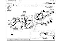
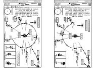
CHANGES: Chart reinstated.| JEPPESEN, 2009. ALL RIGHTS RESERVED.CHANGES: Runway bearings.| JEPPESEN, 1998, 2009. ALL RIGHTS RESERVED.Licensed to Elefant air. Printed on 15 Jul 2009.Notice: After 17 Jul 2009 0901Z, this chart may no longer be valid. Disc 13-2009EIDW/DUBAT4LINK 2F1AT4LINK 2F1AT4LINK 2F1AT4LINK 2F1C8C9C10 C9RPIER BC8C9C10 C9RPIER BC7RC8C9C10 C9RPIER B565554535241R40L414240R 43R43 4445R45 46C12C11C12C11C12C11AT2515049JEPPESEN3 APR 09 10-848C1C261T 62T60T59T57T 58T56TC1C2C3C4C5C7 C6C5RC15C14RC14C1C2C3C4C5C7 C6C5RC7RC8 C13C9C10 C9RC12RC12C11C15C14RC14C19C17 C18C1640L thru 41R42 thru 4445 thru 464849, 5051 thru 5354 thru 56C8C9 thru C10C11C12C1, C2C8C9 thru C10C11C1256T, 57T58T, 59T60T, 61T62TC1 thru C4C5 thru C8C9 thru C10C11C12 thru C14RC15JEPPESENJeppView 3.6.3.0DUBLIN, IRELANDDUBLIN INTLSOUTH APRON RECONSTRUCTION AND PIER E DEVELOPMENTREFER ALSO TO LATEST NOTAMSỊNS COORDINATESPIER BPIER C STAND No COORDINATESAT1AT1AT1AT1B1B1B1B1LINK 1LINK 1LINK 1LINK 1AT2PIER CAT2PIER CAT2PIER CAT2N53 25.5 W006 14.6N53 25.5 W006 14.5N53 25.5 W006 14.4N53 25.4 W006 14.4N53 25.4 W006 14.5N53 25.4 W006 14.6N53 25.4 W006 14.7N53 25.4 W006 14.7N53 25.4 W006 14.8N53 25.3 W006 14.6N53 25.4 W006 14.6ỊNS COORDINATESSTAND No COORDINATESN53 25.5 W006 14.6N53 25.4 W006 14.7N53 25.4 W006 14.8N53 25.3 W006 14.6N53 25.4 W006 14.6N53 25.4 W006 14.6N53 25.4 W006 14.5N53 25.5 W006 14.5N53 25.5 W006 14.4ỊNS COORDINATESSTAND No COORDINATESN53 25.5 W006 14.6N53 25.4 W006 14.7N53 25.4 W006 14.8N53 25.3 W006 14.6N53 25.4 W006 14.6N53 25.4 W006 14.5ỊNS COORDINATESSTAND No COORDINATESC1 thru C4N53 25.5 W006 14.6C5 thru C8N53 25.4 W006 14.7C9 thru C10N53 25.4 W006 14.8C11N53 25.3 W006 14.6C12 thru C14RN53 25.4 W006 14.6C15 thru C17N53 25.4 W006 14.5C18, C19 N53 25.5 W006 14.4Licensed to Elefant air. Printed on 15 Jul 2009.Notice: After 17 Jul 2009 0901Z, this chart may no longer be valid. Disc 13-2009EIDW/DUBJEPPESENApt Elev 242'10-9N53 25.3 W006 16.2VOT 112.506-1406-1506-16284'06-1706-18*ATIS 124.5216272'161^Treesup to05^W295'294'281'272'Engine test site 111Elev217'111^272'280'*DUBLIN Delivery*DUBLIN GroundJEPPESENJeppView 3.6.3.0DUBLIN, IRELANDTower121.87 121.8118.6ElevLIGHT ACFT217'For AIRPORT BRIEFING refer to 10-1P pagesPARKING BD3J2Engine testGElevsites 3 & 4216'53-26 T153-26J14393'1339m29280'291^24 APR 09 .Eff.7.May.NORTHAPRONCENTRALAPRON307'6798'2072mRLINK 5AIS + METP1ControlLINK 4M1Tower314'367'FOR PARKINGPOSITIONSSEE 10-9BP2F3H1LINK 3WESTAPRONM2318'F2LINK 2A F1B2H2B7Y10B3100^CARGOAPRONB1LINK 1E1E3B6B5E6 B4E5 E4E7E2344'8652'2637mElev242'184' 56mStopway28ARP294'280^Elev202'259'1000 2000 3000 40000FeetDUBLIN INTL53-25 Meters 0 200 400 600 800 1000 1200INCURSION53-25HOTSPOT34341^06-1406-1506-1606-1706-18
Licensed to Elefant air. Printed on 15 Jul 2009.Notice: After 17 Jul 2009 0901Z, this chart may no longer be valid. Disc 13-2009EIDW/DUBRWY10JEPPESEN10-9A24 APR 09 .Eff.7.May.ADDITIONAL RUNWAY INFORMATIONUSABLE LENGTHSLANDING BEYONDJEPPESENJeppView 3.6.3.0DUBLIN, IRELANDDUBLIN INTLThreshold Glide Slope TAKE-OFF WIDTHHIRL (60m) CL (15m) HIALS-II TDZRVR7498' 2285m 3148'28 HIRL (60m) CL (15m) HIALS-II TDZRVR7680' 2341m45m112541 PAPI (3.0^)2 HSTIL-E6 (MAX exit speed 50 kts, recommended 35 kts)3 TAKE-OFF RUN AVAILABLE4 TAKE-OFF RUN AVAILABLERWY 10:RWY 28:From rwy head 8652' (2637m)From rwy head 8652' (2637m)twy E7 int 7073' (2156m)twy E2 int 7923' (2415m)twy E6 int 6407' (1953m)twy E5 int 4436' (1352m)5 Additional 299'/91m available as stopway.11 HIRL (61m) ALS PAPI (3.5^)4114' 1254m200'29 HIRL (61m) ALS PAPI (3.0^)61m616 HIRL (60m) HIALS PAPI (3.0^)RVR5826' 1776m200'34 HIRL (60m) ALS PAPI (3.0^) REIL6 61mTAKE-OFF RUN AVAILABLERWY 34:From rwy head 6798' (2072m)twy A/B2/E2 int 5955' (1815m).Standard.ABCD1ApprovedOperatorsHIRL, CL& mult. RVR req125m150mLVP must be in ForceRL, CL& mult. RVR req150m200mRL & CL200m250mTAKE-OFFAll Rwys1RCLM (DAY only) RCLM (DAY only)or RL or RL250m300mNIL(DAY only)400m 500mOperators applying U.S. Ops Specs: CL required below 300m; approved guidance system requiredbelow 150m.CHANGES:Minimums.| JEPPESEN, 1998, 2009. ALL RIGHTS RESERVED.Licensed to Elefant air. Printed on 15 Jul 2009.Notice: After 17 Jul 2009 0901Z, this chart may no longer be valid. Disc 13-2009EIDW/DUBJEPPESENJeppView 3.6.3.0DUBLIN, IRELANDJEPPESEN2 JAN 09 10-9B .Eff.15.Jan.DUBLIN INTL06-16.453-2653-25.953-25.853-25.753-25.653-25.553-25.453-25.206-16.4613 612L C R L C RR CL RC L R C614 615 616L R C L617611L C R84T06-15.2 J206-1506-14.4 06-14.285T86T83S86R86S8387T88T88R88S89TR C L111R C L110 R C L109 R C L10890107R90R91 124T 125 126 1279293 97T96T 94T94R95T8S 7S6R9A 87 6T 6L15L1510A 1411A 11L 13A12AAT4323133 343536L 3636R37 38 39HP2HANGARSCENTRALAPRONMETPIER A39A41R41 42LIGHT ACFTPARKING BHP143R43 44AT1 AT257 56 555458 53 59 5251 60 6162 50 49AT245R45 46HANGAR48NORTHAPRON103104105106RWY11/29RWY 16/3406-16.2ARP06-16.206-1606-1606-15.806-15.806-15.760560360406-15.6600601602606 607610P2P2M2H206-15.466T67T63T06-15.2 06-14.8 06-14.6 06-14.4 06-14.26464L65T68T69T53-2653-25.953-25.753-25.653-25.5CARGOTML53-25.453-25.353-25.2PIER DHANGARSWESTAPRONHANGARSPIER BSOUTHAPRONRWY 10/28LEGENDP1 TaxiwayAT1 Apron taxiwayParking position33ATC service boundaryE4E3RGAT6P1F3LINK 3AT4LINK 2F2AB2E1F1T1YAT6LINK 1B1J1PASSENGERTERMINALPIER CCARGOAPRONF-INNERF-OUTERF-INNERE2F-OUTERB6E5B5B4ControlTowerLINK 5B3M1H1LINK 4CHANGES:Stands.| JEPPESEN, 1998, 2009. ALL RIGHTS RESERVED.
Licensed to Elefant air. Printed on 15 Jul 2009.Notice: After 17 Jul 2009 0901Z, this chart may no longer be valid. Disc 13-2009EIDW/DUBSTAND No.6L6R thru 13A14 thru 15L3132 thru 3435 thru 36R3738, 3939A63T thru 66T67T, 68T69T83, 83S84T85T86R thru 87T88R thru 89T90 thru 94T94R, 95T96T, 97T103104 thru 106107R108L, 108C108R thru 109RJEPPESENJeppView 3.6.3.0DUBLIN, IRELANDJEPPESEN10-9C DUBLIN INTL2 JAN 09 .Eff.15.Jan.INS COORDINATESCOORDINATES STAND No.N53 25.7 W006 14.8N53 25.7 W006 14.9N53 25.7 W006 14.8N53 25.6 W006 14.7N53 25.6 W006 14.8N53 25.5 W006 14.8N53 25.5 W006 14.7N53 25.6 W006 14.7N53 25.6 W006 14.6N53 25.4 W006 14.4N53 25.4 W006 14.3N53 25.3 W006 14.3N53 25.9 W006 15.1N53 26.0 W006 15.3N53 26.0 W006 15.2N53 25.9 W006 15.2N53 25.9 W006 15.1N53 25.8 W006 15.1N53 25.7 W006 15.0N53 25.8 W006 15.0N53 25.8 W006 14.3N53 25.8 W006 14.2N53 25.8 W006 14.8N53 25.9 W006 14.8N53 25.9 W006 14.9110L thru 110R111L thru 111R124T, 125126, 127600601, 602603604, 605606607610 thru 611R612L thru 612R613L thru 613R614L thru 614R615L thru 615R616L thru 616R617L617C, 617RCOORDINATESN53 25.9 W006 15.0N53 25.9 W006 15.1N53 25.8 W006 14.9N53 25.8 W006 14.8N53 25.6 W006 15.5N53 25.7 W006 15.5N53 25.7 W006 15.6N53 25.6 W006 15.7N53 25.6 W006 15.6N53 25.6 W006 15.5N53 25.6 W006 15.6N53 25.6 W006 15.7N53 25.6 W006 15.8N53 25.5 W006 15.9N53 25.4 W006 15.8N53 25.4 W006 15.7N53 25.5 W006 15.6N53 25.5 W006 15.7BRIEFING STRIP TMLicensed to Elefant air. Printed on 15 Jul 2009.Notice: After 17 Jul 2009 0901Z, this chart may no longer be valid. Disc 13-2009EIDW/DUBDUBLIN INTLLOCIDE108.9ILS DMEI D E100^ 108.9 IDEDUBLIN316 OEJEPPESEN11-1MISSED APCH: Climb STRAIGHT AHEAD to 3000' and contact ATC.MISSEDAPCHWITH RADIO FAILURE: Climb STRAIGHT AHEAD to DWE51, then turn LEFTULTAG (IAF)172^53-30O ED5.0 IDED0.5 IDEEI(D)-1EI(P)-18JEPPESENJeppView 3.6.3.0*ATIS DUBLIN ApproachDUBLIN Tower *Ground124.52 121.1 119.55 119.92 118.6 121.8FinalGSILSApt Elev 242'Apch CrsLOMDA(H)2200'100^ 1890' (1648') 442'(200') RWY 242'to ULTAG climbing to 5000'.DME REQUIRED or vectoring to final for ILS.3000(IF)RISAPD12.5IDE028^Motorway running almost parallel withrwy 10/28, 0.6 NM South of rwy.ILS DME reads zero at rwy 10 threshold.Until RISAP MAX 210 KT, after RISAPuntil D8.6 IDE MAX 180 KT, after D8.6IDE MAX 160 KT.100^DWW~1D13.7/R-264 DAP100^D8.624 APR 09 .Eff.7.May.Alt Set: hPa Rwy Elev: 9 hPa Trans level: By ATC Trans alt: 5000'1167'IDEDUBLIND 114.9 U DUBBCOLLINSTOWND 111.2 A PDAPMM735'DUBLIN, IRELANDILS or LOC Rwy 10MISSED APCHWITHRADIO FAILURED28.0 DAP142^322^ULTAGD22.8/R-322 DAP100^051^4000'DWE51335^MSA DUB VORMHA5000MAX FL 140MAX 220 KT53-20324^ 5.03000NASRIEI(R)-16(IAF)IDE DMEALTITUDELOC(GS out)D8.6IDE06-307.02530'MLOMD5.0 IDEGS 1890'UNDESIGNATEDEI(P)-11RESTRICTED AREAEI(R)-1506-2006-106.0 5.0 4.0 3.0 2.02210' 1890' 1570' 1250' 940'3000' GS100^D0.5 IDE465'694'CHANGES: Stands.| JEPPESEN, 1999, 2009. ALL RIGHTS RESERVED.PANS OPS 4Gnd speed-Kts 70 90 100 120 140 160ILS GS orLOC Desc angle 3.00^377 484 538 646 753 861MAP at MM/D0.5 IDE.Standard.3.6 4.5STRAIGHT-IN LANDING RWYILSCHANGES: Chart reindexed. MSA. Procedure. Minimums.10LOC (GS out)0.5TCH 54'RWY 10PAPIHIALS-IICIRCLE-TO-LANDPAPI242'3000'DA(H) 442'(200')DA(H)660'(418')NorthSouthof rwy 10/28 of rwy 10/28FULLMaxLimited ALS out ALS out Kts MDA(H) VIS MDA(H) VISA1500mB135 780' (538') 1600m 780' (538') 1600m100RVR 1500m780' (538') 1500m 780' (538')CRVR 550m RVR 750m RVR 1200m RVR 1200m180RVR 1900m880' (638') 2400m 880' (638') 2400mD205 950' (708') 3600m (858') 3600m1100'| JEPPESEN, 2001, 2009. ALL RIGHTS RESERVED.MMC
Licensed to Elefant air. Printed on 15 Jul 2009.Notice: After 17 Jul 2009 0901Z, this chart may no longer be valid. Disc 13-2009BRIEFING STRIP TMPANS OPS 4EIDW/DUBDUBLIN INTL53-30EI(R)-1653-2006-40EI(R)-15 06-30JEPPESEN24 APR 0911-1AD5.0 IDED0.5 IDEEI(P)-11EI(D)-1JEPPESENJeppView 3.6.3.0*ATIS DUBLIN ApproachDUBLIN Tower *Ground124.52 121.1 119.55 119.92 118.6 121.8LOCFinalGS CAT II ILSApt Elev 242'IDEApch CrsLOM RA 94'DA(H)2200'1890'(1648') 342'(100') RWY108.93000'100^D8.6 IDE D5.0 IDESTRAIGHT-IN LANDING RWY 10RVR 300m06-20D0.5 IDEGS 465'242'EI(P)-18694'UNDESIGNATEDRESTRICTED AREA06-10TCH 54'3.6 4.5RWY 10 242'0.5Gnd speed-Kts 70 90 100 120 140 160HIALS-IIGS3.00^ 377 484 538 646 753 861 PAPI PAPI3000'1.Eff.7.May.MISSED APCH: Climb STRAIGHT AHEAD to 3000' and contact ATC.MISSEDAPCHWITH RADIO FAILURE: Climb STRAIGHT AHEAD to DWE51, then turn LEFTto ULTAG climbing to 5000'.Alt Set: hPa Rwy Elev: 9 hPa Trans level: By ATC Trans alt: 5000'1. Special aircrew and acft certification required. 2. DME REQUIREDor vectoring tofinal for ILS. 3. Motorway running almost parallel with rwy 10/28, 0.6 NM South of rwy.4. ILS DME reads zero at rwy 10 threshold.ULTAG (IAF)3000172^1167'(IF)RISAPD12.5IDE028^DWW~1D13.7/R-264 DAP324^30005.0.Standard.Until RISAP MAX 210 KT, after RISAPuntil D8.6 IDE MAX 180 KT, afterD8.6 IDE MAX 160 KT.100^(IAF)NASRIILS DME100^ I 108.9 D E IDEDUBLIN316 O OEE100^D8.6IDEMLOMGS1890'ABCDRA 94'DA(H) 342'(100')Operators applying U.S. Ops Specs: Autoland or HGS required below RVR 350m.CHANGES: Chart reindexed. MSA. Procedure. Minimums.DUBLIND 114.9 U DUBB1COLLINSTOWND 111.2 A PDAPMMMMC735'DUBLIN, IRELANDCAT II ILS Rwy 10MISSED APCHWITHRADIO FAILURED28.0 DAP142^322^ULTAGD22.8/R-322 DAP100^051^4000'MSADUB VORDWE51335^MHA5000MAX FL 140MAX 220 KT| JEPPESEN, 2001, 2009. ALL RIGHTS RESERVED.BRIEFING STRIP TMPANS OPS 4Licensed to Elefant air. Printed on 15 Jul 2009.Notice: After 17 Jul 2009 0901Z, this chart may no longer be valid. Disc 13-2009EIDW/DUBDUBLIN INTL155^063^243^MHA 5000MAX 220 KTJEPPESENUNDESIGNATEDRESTRICTED AREAEI(P)-11EI(P)-18JEPPESENJeppView 3.6.3.0*ATIS DUBLIN ApproachDUBLIN Tower *Ground124.52 121.1 119.55 119.92 118.6 121.8LOCFinalGSILSApt Elev 242'IACApch Crs DUB VOR DA(H)111.5 161^ 1570' (1353') 417'(200') RWY 217'2200'MISSED APCH: Climb on track 155^ towards NDB to 3000' andcontact ATC.MISSED APPROACH WITH RADIO FAILURE: Climb STRAIGHT AHEAD to DWS77, then4000'53-3553-30ROKNAD17.9/R-063 DUBDWS77D5.7 IACLOC(GS out)D23.0 DUB(IAF)ULTAG06-308.02820'12.8115^53-2524 APR 09 .Eff.7.May.turn LEFT to ROKNA climbing to 5000'.Alt Set: hPa Rwy Elev: 8 hPa Trans level: By ATC Trans alt: 5000'DME REQUIREDMISSED APCH FIXWITH RADIO FAILUREIAC DMEALTITUDED8.73000BAPDA1(IF)D12.5 IAC161^5.1IACD4.1 IAC3000' GS1570'161^ERUDA(IAF)D10.6/R-010 DUBROKNA161^30003.81100T241^or vectoring to final forILS. ILS DME reads zero at rwy 16 threshold.Full scale fly down indication may notbe maintained when above glide pathsector. Until BAPDA MAX 210 KT, afterBAPDA until D8.7 IAC MAX 180 KT, afterD8.7 IAC MAX 160 KT.06-20EI(D)-1KILLINEYK 378 L KLYYEI(D)-17.0 6.0 5.0 4.0 3.0 2.02500' 2180' 1870' 1550' 1230' 910'VOR820'DATCH 54'4.6 3.1RWY 16 217'1.0Gnd speed-Kts 70 90 100 120 140 160HIALS3000'ILS GS orPAPI PAPI377 484 538 646 753 861on 155^LOC Desc angle 3.00^KLY378MAP at D1.0 IAC.Standard. STRAIGHT-IN LANDING RWY 16CIRCLE-TO-LANDILSLOC (GS out)NorthSouthof rwy 10/2 8 of rwy 10/28DA(H) 417' (200')DA(H) 590'(373')MaxFULL Limited ALS out ALS out Kts MDA(H) VIS MDA(H) VISA100 780'(538') 1500m 780' (538') 1500mRVR1500mB135 780' (538') 1600m 780' (538') 1600mCRVR 550m RVR 750m RVR1200m RVR 1000m180 880'(638') 2400m 880' (638') 2400mRVR1700mD205 950'(708')3600m 1100'(858') 3600mCHANGES: Chart reindexed. MSA. Procedure. Minimums.DUBLIN, IRELAND11-2 ILS or LOC Rwy 16279^14.330001NOT TO SCALED8.7IAC735'ILS DMEI A C161^ 111.5 IACD1.0IACD1.0DUBLIND 114.9 U DUBBD4.1 IAC155^694'IAC06-10051^335^MSADUB VOR06-00| JEPPESEN, 2001, 2009. ALL RIGHTS RESERVED.
Licensed to Elefant air. Printed on 15 Jul 2009.Notice: After 17 Jul 2009 0901Z, this chart may no longer be valid. Disc 13-2009BRIEFING STRIP TMEIDW/DUBDUBLIN INTLJEPPESEN11-3MISSED APCH: Climb STRAIGHT AHEAD to 3000' and contact ATC.MISSEDAPPROACH WITH RADIO FAILURE: Climb STRAIGHT AHEAD to OE NDB, thenJEPPESENJeppView 3.6.3.0*ATIS DUBLIN ApproachDUBLIN Tower *Ground124.52 121.1 119.55 119.92118.6 121.8LOCFinalGSILSApt Elev 242'IDWApch CrsLOMDA(H)1545' (1343') 402' (200') RWY 202'2200'111.35 280^24 APR 09 .Eff.7.May.turn RIGHT to ROKNA climbing to 5000'. Avoid routing through EI(D)-1 when active.Alt Set: hPa Rwy Elev: 7 hPa Trans level: By ATC Trans alt: 5000'DUBLIN, IRELANDILS or LOC Rwy 28(IAF)051^4000'335^MSADUB VORROKNABRIEFING STRIP TMLicensed to Elefant air. Printed on 15 Jul 2009.Notice: After 17 Jul 2009 0901Z, this chart may no longer be valid. Disc 13-2009EIDW/DUBDUBLIN INTLJEPPESEN24 APR 0911-3A.Eff.7.May.JEPPESENJeppView 3.6.3.0DUBLIN, IRELANDCAT II ILS Rwy 28*ATIS DUBLIN ApproachDUBLIN Tower *Ground124.52 121.1 119.55 119.92 118.6 121.8LOCFinalGSCAT II ILSApt Elev 242'IDWApch CrsLOM RA 106'DA(H)111.35 280^ 1545' (1343')RWY 202'2200'302'(100')MISSED APCH: Climb STRAIGHT AHEAD to 3000' and contact ATC.MISSEDAPPROACHWITH RADIO FAILURE: Climb STRAIGHT AHEAD to OE NDB, thenturn RIGHT to ROKNA climbing to 5000'. Avoid routing through EI(D)-1 when active.MSAAlt Set: hPa Rwy Elev: 7 hPa Trans level: By ATC Trans alt: 5000'DUB VOR(IAF) ROKNA051^4000'335^PANS OPS 453-30UNDESIGNATEDRESTRICTED AREAO EDUBLIN Baldonnel316 OEEI(R)-15LOC(GS out)063^EI(P)-1106-20MISSED APCH D23.0 DUBWITHRADIO FAILUREROKNAD17.9/R-063 DUBEI(R)-15MHA 5000EI(R)-23MAX 220 KT280^IDW DMEALTITUDE243^MMD0.5 IDW53-20DUBLIND114.9 DUBDUBLINO 397 POPEI(P)-18UNDESIGNATEDRESTRICTED AREAD U B694'D4.0 IDW06-1006-00(IAF) 05-502.0 3.0 4.0 5.0 6.0890' 1210' 1530' 1850' 2170'D0.5 IDWGS 425'ILS DME280^ I 111.35 D W IDWD4.0 IDWGS(IF)LAPMOD11.0 IDWTULSOTCH 54'LOC1500'RWY 28 202'0.53.5 3.2Gnd speed-Kts 70 90 100 120 140 160HIALS-IIILS GS orPAPI PAPI377 484 538 646 753 861LOC Desc angle 3.00^3000'MAP at MM/D0.5 IDW.Standard. STRAIGHT-IN LANDING RWY 28CIRCLE-TO-LANDILSLOC (GS out)NorthSouthof rwy 10/2 8DA(H) 402' (200')DA(H) 630' (428')of rwy 10/28FULLMaxLimited ALS out ALS out Kts MDA(H) VIS MDA(H) VISA1001500mRVR1500m780'(538') 780'(538') 1500mB135 780' (538') 1600m 780' (538') 1600mCRVR 550m RVR 750m RVR 1200m RVR 1300m180 880' (638') 2400m 880' (638') 2400mRVR2000mD205 950'(708')3600m 1100'(858') 3600mCHANGES: Chart reindexed. MSA. Procedure. Minimums.193^or vectoring to final forILS. Motorway running almost parallelwith rwy 10/28, 0.6 NM South of rwy.ILS DME reads zero at rwy 28 threshold.Until LAPMO MAX 210 KT, after LAPMOuntil D7.2 IDW MAX 180 KT, after D7.2IDW MAX 160 KT.CMMDME REQUIREDD7.2IDW280^LOM M D7.21545'280^IDW347^250025002500'| JEPPESEN, 2001, 2009. ALL RIGHTS RESERVED.PANS OPS 453-30UNDESIGNATEDRESTRICTED AREAO EDUBLIN EI(R)-15316 OEEI(P)-11MISSED APCH D23.0 DUBWITHRADIO FAILUREEI(R)-15EI(R)-23 ROKNAD17.9/R-063 DUBBaldonnel MHA 5000MAX 220 KT53-20EI(P)-18UNDESIGNATEDRESTRICTED AREAD0.5 IDWGS 425'RWY 283.5 3.20.5Gnd speed-Kts 70 90 100 120 140 160HIALS-II3000'GS 3.00^ 377 484 538 646 753 861 PAPI PAPI.Standard.1063^06-20243^280^202'MMD0.5 IDWD 114.9 DUBLINU DUBBO 397 DUBLINPOP694'TCH 54'D4.0 IDWDME REQUIRED06-10300m 106-00(IAF)TULSO 05-50LOM M D7.2IDWD4.0 IDWGS1545'2500'Operators applying U.S. Ops Specs: Autoland or HGS required below RVR 350m.CHANGES: Chart reindexed. MSA. Procedure. Minimums.| JEPPESEN, 2001, 2009. ALL RIGHTS RESERVED.193^or vectoring to final for ILS.Special aircrew & acft certificationrequired. Motorway running almost parallelwith rwy 10/28, 0.6 NM South of rwy.ILS DME reads zero at rwy 28 threshold.Until LAPMO MAX 210 KT, after LAPMOuntil D7.2 IDW MAX 180 KT, after D7.2IDW MAX 160 KT.CMMSTRAIGHT-IN LANDING RWY 28CAT II ILSABCDRA 106'DA(H)302'(100')RVRILS DMEI D W280^ 111.35 IDW280^D7.2IDW280^280^(IF)LAPMOD11.0 IDW347^25002500
Licensed to Elefant air. Printed on 15 Jul 2009.Notice: After 17 Jul 2009 0901Z, this chart may no longer be valid. Disc 13-2009BRIEFING STRIP TMPANS OPS 4EIDW/DUBDUBLIN INTLVORDAP111.253-20EI(R)-16JEPPESEN13-1UNDESIGNATEDRESTRICTED AREAEI(P)-18EI(R)-15EI(P)-1106-3006-2006-107.06.0 5.0 4.0 3.0 2.02660' 2340' 2020' 1710' 1390' 1070'JEPPESENJeppView 3.6.3.0*ATIS DUBLIN ApproachDUBLIN Tower *Ground124.52 121.1 119.55 119.92 118.6 121.8Final Procedure AltApt ElevApch Crs D8.2 DAPClimb STRAIGHT AHEAD to DWE51, then turn LEFTto ULTAG climbing to 5000'.4000'Alt Set: hPa Rwy Elev: 9 hPa Trans level: By ATC Trans alt: 5000' MSA DUB VOREI(D)-1 MISSED APCHWITHRADIO FAILURED28.0 DAP735'53-303000'D8.2DAP100^ 3000'DUBLIN316 O OEED4.5 DAPD4.5 DAPGnd speed-Kts 70 90 100 120 140 160Descent Angle 3.00^ 369 474 527 632 737 843MAP at D0.5 DAPRVR 1300m1890'24 APR 09 .Eff.7.May.RVR 1500mRVR 2000mDA(H)680'(438')DDCOLLINSTOWNA P111.2 DAPDAP242'242'(2798')RWYMISSED APCH: Climb STRAIGHT AHEAD to 3000' and contact ATC.MISSEDAPCHWITH RADIO FAILURE:ULTAG (IAF)300016.0 172^(IF)RISAPD12.0DAP028^3.93.8100^30001100TDWW~1D13.7/R-264 DAP324^ 5.03000.Standard.ABCD1167'DAP DMEALTITUDEDME REQUIRED.Motorway running almost parallelwith rwy 10/28, 0.6 NM South of rwy.Until RISAP MAX 210 KT, after RISAPuntil D8.2 DAP MAX 180 KT, afterD8.2 DAP MAX 160 KT.(IAF)NASRI100^D8.2DAP100^DAOE NDB100^3.7 4.0STRAIGHT-IN LANDING RWYDA(H) 680'(438')CHANGES: Chart reindexed. MSA. Procedure. Minimums.100^10ALS outD0.5DAPDUBLIND 114.9 U DUBBDAP VORD0.50.50.4 0DUBLIN, IRELANDVOR Rwy 10694'142^ULTAGD22.8/R-322 DAP100^PAPI051^322^RWY 10DWE51HIALS-IIPAPI2200'MHA5000MAX FL 140MAX 220 KT1.0750'242'3000'CIRCLE-TO-LANDNorthof rwy 10/28Southof rwy 10/28MaxKts MDA(H) VIS MDA(H) VIS100 780' (538') 1500m 780' (538') 1500m135 780' (538') 1600m 780' (538') 1600m180205880' (638') 2400m950' (708') 3600m880' (638') 2400m(858') 3600m1100'335^| JEPPESEN, 2006, 2009. ALL RIGHTS RESERVED.BRIEFING STRIP TMPANS OPS 4Licensed to Elefant air. Printed on 15 Jul 2009.Notice: After 17 Jul 2009 0901Z, this chart may no longer be valid. Disc 13-2009EIDW/DUBDUBLIN INTLJEPPESEN*ATIS DUBLIN ApproachDUBLIN Tower *Ground124.52 121.1 119.55 119.92 118.6 121.8VORFinal Procedure AltDA(H) Apt Elev 242'DUBApch CrsD4.6114.9 161^ 3000' (2783') 590'(373')RWY 217'MISSED APCH: Climb on track 155^ towards NDB to 3000' andcontact ATC.EI(R)-15EI(P)-11EI(P)-18JEPPESENJeppView 3.6.3.0MSAMISSED APPROACH WITH RADIO FAILURE: Climb STRAIGHT AHEAD to DWS77, thenDUB VORturn LEFT to ROKNA climbing to 5000'.Alt Set: hPa Rwy Elev: 8 hPa Trans level: By ATC Trans alt: 5000'(IAF)EI(D)-1ULTAGERUDAEI(D)-1(IAF)D10.6/R-010BAPDAROKNA(IF)1 161^3000D8.4 1 3.81100T NOT TO SCALE53-30155^DWS77DUB DMEROKNAD17.9/R-063063^3000'D4.6161^161^UNDESIGNATEDRESTRICTED AREAD3.1155^1.0694'06-100KILLINEYK 378 L KLYYALTITUDE 2850' 2530' 2210' 1890' 1570' 1250' 940' 620'1570'820'DA4.63.14.1Gnd speed-Kts 70 90 100 120 140 160Descent Angle 3.00^ 369 474 527 632 737 843MAP at D3.1 after VOR.Standard.ABCDD23.04.0 beforeRVR 1000m06-30243^MHA 5000MAX 220 KTMISSED APCH FIXWITH RADIO FAILURE12.8115^3000DME REQUIRED.Until BAPDA MAX 210 KT, afterBAPDA until D4.6 MAX 180 KT,after D4.6 MAX 160 KT.53-2024 APR 09 .Eff.7.May.5.1241^06-20RVR 1500mRVR 1700m279^3.0 before 2.0 before 1.0 before 0.0 1.0 after 2.0 after 3.0 afterVOR161^STRAIGHT-IN LANDING RWYDA(H) 590'(373')CHANGES: Chart reindexed. MSA. Procedure. Minimums.16ALS outDUBLIN, IRELAND13-2 VOR Rwy 16D4.6161^DPAPI14.33000D U BDUBLIN114.9 DUBD3.1HIALSPAPI3000'RWY 16 217'on051^155^2200'4000'06-00KLY378CIRCLE-TO-LANDNorthof rwy 10/2 8Southof rwy 10/28MaxKts MDA(H) VIS MDA(H) VIS100135180780'(538') 1500m780' (538') 1600m880' (638') 2400m780'(538') 1500m780' (538') 1600m880' (638') 2400m205 950'(708') 3600m 1100'(858') 3600m335^| JEPPESEN, 2001, 2009. ALL RIGHTS RESERVED.
Licensed to Elefant air. Printed on 15 Jul 2009.Notice: After 17 Jul 2009 0901Z, this chart may no longer be valid. Disc 13-2009BRIEFING STRIP TMPANS OPS 4EIDW/DUBDUBLIN INTLDUBLIN Baldonnel316 OEEI(R)-15DAP DMEALTITUDE[TCH 53']UNDESIGNATEDRESTRICTED AREADAP[MD28]JEPPESEN13-3MISSED APCH: Climb STRAIGHT AHEAD to 3000' and contact ATC.MISSEDAPPROACH WITH RADIO FAILURE: Climb STRAIGHT AHEAD to OE NDB, then53-30[3.00^]DAP[FD28]DAP[FD28]JEPPESENJeppView 3.6.3.0*ATIS DUBLIN ApproachDUBLIN Tower *Ground124.52 121.1 119.55 119.92118.6 121.8Final Procedure Alt DA(H) Apt Elev 242'Apch Crs D9.1 DAP280^ 2500' (2298') 690' (488')RWY 202'2200'VORDAP111.2O ECOLLINSTOWND111.2 D A DAP P063^06-10 06-00 (IAF) TULSO 05-504.0 5.0 6.0 7.0 8.0940' 1250' 1570' 1890' 2210'Gnd speed-Kts 70 90 100 120 140 160Descent angle [3.00^] 372 478 531 637 743 849MAP at D2.4 DAPRVR 1500m243^280^D2.4UNDESIGNATEDDAPRESTRICTED AREA[MD28]EI(P)-1106-20EI(P)-18MISSED APCH D23.0 DUBWITHRADIO FAILUREROKNA694'D17.9/R-063 DUB53-20EI(R)-15MHA 5000EI(R)-23 MAX 220 KT24 APR 09 .Eff.7.May.turn RIGHT to ROKNA holding climbing to 5000'. Avoid routing through EI(D)-1 whenactive.Alt Set: hPa Rwy Elev: 7 hPa Trans level: By ATC Trans alt: 5000'RWY 28.Standard.ABCDDUBLIND 114.9 U DUBBDAP VOR202' 0.5STRAIGHT-IN LANDING RWYDA(H)690'CHANGES: MSA. Arrivals. Procedure. Minimums.Motorway running almost parallel withrwy 10/28, 0.6 NM South of rwy.Until LAPMO MAX 210 KT, after LAMPOuntil D9.1 DAP MAX 180 KT, after D9.1DAP MAX 160 KT.D2.4DME REQUIRED.(488')280^28ALS outRVR1500mCMV 2300mDUBLINO 397 POPD5.9 DAP280^OP NDBD5.9 DAP280^D9.11550'DA3.5 3.23.8280^2500800TD9.1280^DUBLIN, IRELANDVOR Rwy 28(IAF) ROKNA15.4193^(IF)LAPMOD12.9 DAP347^2500'2500250012.8051^4000'HIALS-IIPAPI PAPI3000'CIRCLE-TO-LANDNorthSouthof rwy 10/2 8 of rwy 10/28MaxKts MDA(H) VIS MDA(H) VIS100 780'(538') 1500m 780'(538') 1500m135 780' (538') 1600m 780' (538') 1600m180 880' (638') 2400m 880' (638') 2400m205 950'(708')3600m 1100'(858') 3600m| JEPPESEN, 2006, 2009. ALL RIGHTS RESERVED.335^MSADUB VORBRIEFING STRIP TMPANS OPS 4Licensed to Elefant air. Printed on 15 Jul 2009.Notice: After 17 Jul 2009 0901Z, this chart may no longer be valid. Disc 13-2009EIDW/DUBDUBLIN INTLEI(MOA)-4EI(R)-23EI(R)-15DUB VORRWY 34 202'EI(P)-11BaldonnelEI(P)-18UNDESIGNATEDRESTRICTED AREAD6.2JEPPESEN13-49.01460'DA3.8Gnd speed-Kts 70 90 100 120 140 160Descent Angle 3.00^ 369 474 527 632 737 843MAP at D6.2 DUBEI(D)-110.01780'D10.01780'950'4.0341^D14.0DUB3000'JEPPESENJeppView 3.6.3.0DUBLIN, IRELANDVOR Rwy 34*ATIS DUBLIN ApproachDUBLIN Tower *Ground124.52 121.1 119.55 119.92 118.6 121.8VORFinal Procedure AltDA(H) Apt Elev 242'DUBApch Crs D14.0 DUB2200'114.9 341^ 3000' (2798') 650'(448')RWY 202'MISSED APCH: Climb STRAIGHT AHEAD to 3000' and contact ATC.MISSED APCH WITH RADIO FAILURE: Climb STRAIGHT AHEAD to DWN26, then turnRIGHT to TULSO climbing to 5000'.MISSED APCH WITHRADIO FAILUREDWN26 MHA 5000D 0.9 DUB MAX 220 KTD28.0 BAL53-3053-20110^290^TULSOD22.9/R-110 BAL666'1296'53-40341^1257'1938'24 APR 09 .Eff.7.May.Alt Set: hPa Rwy Elev: 7 hPa Trans level: By ATC Trans alt: 5000'341^.Standard.BALDONNELDB 115.8 A BALLEI(R)-162126'1923'1086'06-30 06-20 2890'DUB DMEALTITUDE7.0830'8.01150'1.0DUB735'694'34Due to terrain acft beingvectored from the Eastshould turn RIGHT tointercept R-161 inboundDUB to complete apch.DD6.2341^DUBLIND 114.9 U DUB BD10.030001900TD14.0DUBAMDILPAPI PAPIREIL3000'STRAIGHT-IN LANDING RWYCIRCLE-TO-LANDNorthSouthDA(H) 650'(448')of rwy 10/2 8 of rwy 10/28MaxALS out Kts MDA(H) VIS MDA(H) VISA100 780'(538') 1500m 780'(538') 1500mRVR 1500mB135 780' (538') 1600m 780' (538') 1600mC 180 880' (638') 2400m 880' (638') 2400mRVR 1900mCMV 2100mD 205 950'(708')3600m 1100'(858') 3600mCHANGES: MSA. Procedure. Minimums.| JEPPESEN, 1999, 2009. ALL RIGHTS RESERVED.DUB341^(IF)4.05.0252^283^INTOPD18.0 DUB06-10 06-00DUBDUB193^24.211.02100'300010.0ROKNADME REQUIRED.Until INTOP MAX 210 KT,after INTOP until D14.0DUB MAX 180 KT, afterD14.0 DUB MAX 160 KT.3000(IAF)05-5012.02420'(IAF)TULSOALS051^4000'335^MSA DUB VOR13.02740'