Download Guidebook as .pdf (3.4 Mb) - Carolina Geological Society
Download Guidebook as .pdf (3.4 Mb) - Carolina Geological Society
Download Guidebook as .pdf (3.4 Mb) - Carolina Geological Society
- No tags were found...
You also want an ePaper? Increase the reach of your titles
YUMPU automatically turns print PDFs into web optimized ePapers that Google loves.
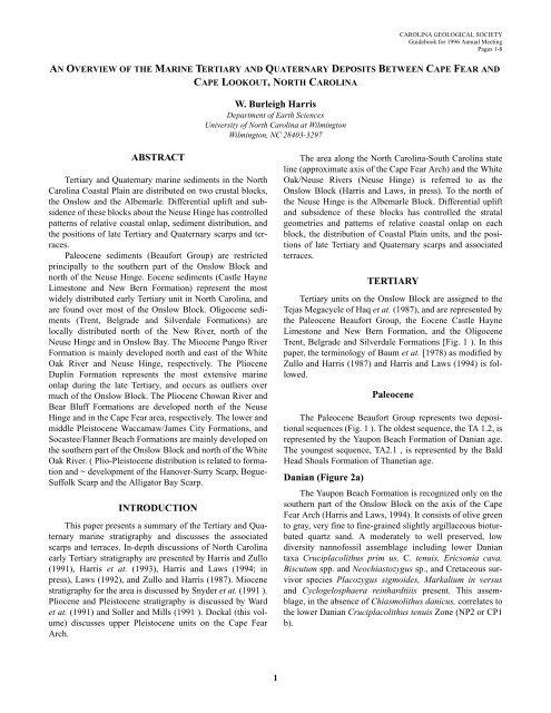
CAROLINA GEOLOGICAL SOCIETY<strong>Guidebook</strong> for 1996 Annual MeetingPages 1-8AN OVERVIEW OF THE MARINE TERTIARY AND QUATERNARY DEPOSITS BETWEEN CAPE FEAR ANDCAPE LOOKOUT, NORTH CAROLINAW. Burleigh HarrisDepartment of Earth SciencesUniversity of North <strong>Carolina</strong> at WilmingtonWilmington, NC 28403-3297ABSTRACTTertiary and Quaternary marine sediments in the North<strong>Carolina</strong> Co<strong>as</strong>tal Plain are distributed on two crustal blocks,the Onslow and the Albemarle. Differential uplift and subsidenceof these blocks about the Neuse Hinge h<strong>as</strong> controlledpatterns of relative co<strong>as</strong>tal onlap, sediment distribution, andthe positions of late Tertiary and Quaternary scarps and terraces.Paleocene sediments (Beaufort Group) are restrictedprincipally to the southern part of the Onslow Block andnorth of the Neuse Hinge. Eocene sediments (C<strong>as</strong>tle HayneLimestone and New Bern Formation) represent the mostwidely distributed early Tertiary unit in North <strong>Carolina</strong>, andare found over most of the Onslow Block. Oligocene sediments(Trent, Belgrade and Silverdale Formations) arelocally distributed north of the New River, north of theNeuse Hinge and in Onslow Bay. The Miocene Pungo RiverFormation is mainly developed north and e<strong>as</strong>t of the WhiteOak River and Neuse Hinge, respectively. The PlioceneDuplin Formation represents the most extensive marineonlap during the late Tertiary, and occurs <strong>as</strong> outliers overmuch of the Onslow Block. The Pliocene Chowan River andBear Bluff Formations are developed north of the NeuseHinge and in the Cape Fear area, respectively. The lower andmiddle Pleistocene Waccamaw/James City Formations, andSoc<strong>as</strong>tee/Flanner Beach Formations are mainly developed onthe southern part of the Onslow Block and north of the WhiteOak River. ( Plio-Pleistocene distribution is related to formationand ~ development of the Hanover-Surry Scarp, Bogue-Suffolk Scarp and the Alligator Bay Scarp.INTRODUCTIONThis paper presents a summary of the Tertiary and Quaternarymarine stratigraphy and discusses the <strong>as</strong>sociatedscarps and terraces. In-depth discussions of North <strong>Carolina</strong>early Tertiary stratigraphy are presented by Harris and Zullo(1991), Harris et at. (1993), Harris and Laws (1994; inpress), Laws (1992), and Zullo and Harris (1987). Miocenestratigraphy for the area is discussed by Snyder et at. (1991 ).Pliocene and Pleistocene stratigraphy is discussed by Wardet at. (1991) and Soller and Mills (1991 ). Dockal (this volume)discusses upper Pleistocene units on the Cape FearArch.The area along the North <strong>Carolina</strong>-South <strong>Carolina</strong> stateline (approximate axis of the Cape Fear Arch) and the WhiteOak/Neuse Rivers (Neuse Hinge) is referred to <strong>as</strong> theOnslow Block (Harris and Laws, in press). To the north ofthe Neuse Hinge is the Albemarle Block. Differential upliftand subsidence of these blocks h<strong>as</strong> controlled the stratalgeometries and patterns of relative co<strong>as</strong>tal onlap on eachblock, the distribution of Co<strong>as</strong>tal Plain units, and the positionsof late Tertiary and Quaternary scarps and <strong>as</strong>sociatedterraces.TERTIARYTertiary units on the Onslow Block are <strong>as</strong>signed to theTej<strong>as</strong> Megacycle of Haq et at. (1987), and are represented bythe Paleocene Beaufort Group, the Eocene C<strong>as</strong>tle HayneLimestone and New Bern Formation, and the OligoceneTrent, Belgrade and Silverdale Formations [Fig. 1 ). In thispaper, the terminology of Baum et at. [1978) <strong>as</strong> modified byZullo and Harris (1987) and Harris and Laws (1994) is followed.PaleoceneThe Paleocene Beaufort Group represents two depositionalsequences (Fig. 1 ). The oldest sequence, the TA 1.2, isrepresented by the Yaupon Beach Formation of Danian age.The youngest sequence, TA2.1 , is represented by the BaldHead Shoals Formation of Thanetian age.Danian (Figure 2a)The Yaupon Beach Formation is recognized only on thesouthern part of the Onslow Block on the axis of the CapeFear Arch (Harris and Laws, 1994). It consists of olive greento gray, very fine to fine-grained slightly argillaceous bioturbatedquartz sand. A moderately to well preserved, lowdiversity nannofossil <strong>as</strong>semblage including lower Daniantaxa Cruciplacolithus prim us, C. tenuis, Ericsonia cava,Biscutum spp. and Neochi<strong>as</strong>tozygus sp., and Cretaceous survivorspecies Placozygus sigmoides, Markalium in versusand Cyclogelosphaera reinhardtiiis present. This <strong>as</strong>semblage,in the absence of Chi<strong>as</strong>molithus danicus, correlates tothe lower Danian Cruciplacolithus tenuis Zone (NP2 or CP1b).1


