MATRIX # - Austin ISD
MATRIX # - Austin ISD
MATRIX # - Austin ISD
- No tags were found...

You also want an ePaper? Increase the reach of your titles
YUMPU automatically turns print PDFs into web optimized ePapers that Google loves.
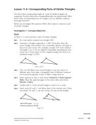
Course: Grade 5 Social Studies<strong>Austin</strong> <strong>ISD</strong> Curriculum Road Map1 st 9 WeeksStudent Work Products/Assessment EvidencePerformance Tasks• Students will use their ISN to record information on map studies,process writing on what they are learning and vocabulary graphicorganizers .• Students will create map that shows physical geographic features ofthe World, using key geographic terms, and the location of <strong>Austin</strong>.• Students will examine quotations from a primary source, HarcourtHorizons, United States History, p. 17, a quote from “America theBeautiful,” by Katharine Lee Bates, 1893, and explain what thedescription means.• Students will locate on a map important physical features such as theRocky Mountains, Mississippi River, and Great Plains usingtechnology.• Students will write a journal entry about the geography and regions ofthe U.S. using newly acquired geographic terms (ELPS 5B-Writing).• Students will partner to complete a social studies skill-builder tounderstand the physical features of the United States along with aseries of maps including world, landforms, latitude and longitude,regions and states of the United States (ELPS 3E- Speaking).• Students will use technology to derive meaning about the geographyof the U.S. on the planet Earth from a variety of media includingtechnology using lesson Virtual Field Trip.• Differentiated (enrichment): Students will create and use graphicvocabulary cards of geographic terms with written definitions in theirown words (ELPS 1C- Learning Strategies).• Differentiated (intervention): Students will create and use graphicvocabulary cards of geographic terms with labels and concisedefinitions in their own words (ELPS 1C- Learning Strategies).Other Evidence (i.e. unit tests, open ended exams, quiz, essay, studentwork samples, observations, etc.)• ISN reflections on map studies and vocabulary words• Formal and informal assessments• Harcourt Horizons, United States History Activity Book,o Land and Regions, p. 6o Use Elevation Maps, p. 7o Bodies of Water, p. 8o Climate and VegetationRegions, p. 9o Using the Land, p. 10o Where People Live and Work. p. 11o Use Latitude and Longitude, p. 12• Student work samples• Teacher observationsLearning PlanLesson/Activity/Module Name Teacher Resource Student Resource Technology (Media, website, etc.) OtherLesson: Virtual Field Tripwith Google EarthPortfolio: GeographyDays: 6-15o Harcourt Horizons:United StatesHistory pp16-53(Chapter1)Google Earth maps at:www.earth.google.comPortfolio: 1 st 20 Days 5 th Grade• Harcourt Horizons, UnitedStates History TE, pp.16-53• Harcourt Horizons, UnitedStates History Activity Book,o Land and Regions, p. 6o Use Elevation Maps, p. 7o Bodies of Water, p. 8o Climate and VegetationRegions, p. 9o Google Earth mapsat:www.earth.google.comReadiness Standards and Supporting Standards are not designated for Grade 5 level.© <strong>Austin</strong> Independent School District Grade 5 Social Studies Page 6 of 16