DXO CRL IDTW YQG
DXO CRL IDTW YQG
DXO CRL IDTW YQG
- No tags were found...

Create successful ePaper yourself
Turn your PDF publications into a flip-book with our unique Google optimized e-Paper software.
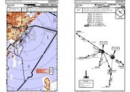
Licensed to IT. Printed on 21 Sep 2009.Notice: After 25 Sep 2009 0901Z, this chart may no longer be valid. Disc 18-2009KDTW/DTW14 NOV 08DETROIT METRO WAYNE CO 10-2CD-ATIS133.67JEPPESENSPICA TWO ARRIVAL (SPICA.SPICA2)JEPPESENJeppView 3.6.3.1DETROIT, MICH.STAR.BUFFALO(BUF.SPICA2)267^030^309^(ERI.SPICA2)ERIE68269^4345002100T 2100T450031269^(YQO.SPICA2)AYLMERSPICAN42 30.5W082 32.8114.0ECKECK 177^SVMSVM114.3085^ D47D74R070^D10D2653000D31300010070^250^VERNRN42 24.2 W082 50.5WOLISN42 37.6W081 34.8R094^45002200T46274^N42 01.0 W080 17.645002300T5550001800TAYLMERD(H) 114.2 YQON42 42.4 W080 53.3MOAWKN42 45.0W079 51.0BUFFALO(H) 116.4 BUFN42 55.7 W078 38.8163000250^ D41N42 17.2 W083 09.9WITKRN42 26.4 W082 44.4RIKKEROUTINGFrom over SPICA/D74 YQO via <strong>DXO</strong> R-070 to WITKR/D10 <strong>DXO</strong>,EXPECT RADAR vectors to final approach course.From over SPICA/D74 YQO via <strong>DXO</strong> R-070 to VERNR/D26 <strong>DXO</strong>,EXPECT RADAR vectors to final approach course.MSA <strong>DXO</strong> VORApt Elev645'Alt Set: INCHESTrans level: FL 180 Trans alt: 18000'DME required..Eff.20.Nov..LANDINGRWYS 3L/R & 4L/REXPECT RADARvectors to finalapproach courseDETROITD(H)<strong>DXO</strong> 113.4 N42 12.8 W083 22.0RWY3L/R, 4L/R21L/R, 22L/RLANDING RWYS 21L/R & 22L/REXPECT RADAR vectorsto final approach courseTURBOJETSEXPECT clearance to crossat12000'TURBOPROPSEXPECT clearance to crossat11000'YQONOT TO SCALED(H)DBUFERIE109.4 ERI2800'CHANGES:None. | JEPPESEN, 2007, 2008. ALL RIGHTS RESERVED.Licensed to IT. Printed on 21 Sep 2009.Notice: After 25 Sep 2009 0901Z, this chart may no longer be valid. Disc 18-2009KDTW/DTWDETROIT METRO WAYNE COD-ATIS Apt Elev133.67 645'JEPPESEN28 JUL 06 10-2D.Eff.3.Aug.Alt Set: INCHESTrans level: FL180 Trans alt: 18000'JEPPESENJeppView 3.6.3.1DETROIT, MICH2800'.STAR.R141^(H)SALEM1. RADAR required.2. DME required from HNN to RONCO, and from<strong>YQG</strong> to CASIO.WEEDA ONE ARRIVAL (HNN.WEEDA1)D<strong>DXO</strong>113.4 N42 12.8 W083 22.0MSA <strong>DXO</strong> VORWINDSORD<strong>YQG</strong> 113.8 N42 15.0 W082 49.7DDirect distance from SVM to:(L)WEEDADetroit Co 16 NMN41 43.0 W083 03.9TURBOJETSDTW NORTH FLOW:EXPECT clearance to cross at11000'DTW SOUTH FLOW:EXPECT clearance to cross at12000'DRYERD(H)DJB 113.6 N41 21.5 W082 09.7CASION40 54.5W082 25.6COLTZN40 29.5BELLAIREDW082 18.3(H)117.1 AIRN40 01.0 W080 49.0MILNRN39 58.8W082 13.3SUBWYN39 41.9W082 10.6RONCON39 12.1W082 05.8(H)SVM 114.3 SVMEXPECT RADARDETROITvectors to final(H)approach courseN42 24.5 W083 35.7Metro Wayne D<strong>CRL</strong>CARLETON115.7 N42 02.9 W083 27.5AQQUAWATERVILLEN41 15.4DW082 31.8(L)VWV 113.1 N41 27.1 W083 38.3ROSEWOODD(H)ROD 117.5 N40 17.3 W084 02.6NOT TO SCALER153^484000D27060^333^R173^1200036255^D61D63321^22FL180353^FL18025D105D83 D108173^086^FL39031107^260^17FL390 D57 FL39030D74 D176^27FL390356^HENDERSONDHNN 115.9 HNNN38 45.2 W082 01.6CHANGES:ROUTINGFrom over HNN via HNN R-356 to COLTZ, then via <strong>YQG</strong> R-173 to AQQUA, then via <strong>CRL</strong> R-141to WEEDA, then via SVM R-153 to SVM. EXPECT RADAR vectors to final approach course.WEEDA crossing restriction.| JEPPESEN SANDERSON, INC., 2006. ALL RIGHTS RESERVED.
095^D3011Licensed to IT. Printed on 21 Sep 2009.Notice: After 25 Sep 2009 0901Z, this chart may no longer be valid. Disc 18-2009KDTW/DTWDETROIT METRO WAYNE CODETROIT Departure (R)Jets Props132.02 134.3Apt ElevJEPPESEN4 APR 0810-3 .Eff.10.Apr.Trans level: FL180 Trans alt: 18000'1. RADAR required.JEPPESENJeppView 3.6.3.1DETROIT, MICHSee Graphic 2. When using this departure, file the appropriate depicted fixand route.AKRON TWO DEPARTURE (ACO2.ACO).SID.040^015^358^106^ANN ARBOR MICHAnn Arbor Mun839PONTIAC MICHOakland Co Intl980 A JETS DETROIT MICHDETROIT MICHWillow Run716DETROITD(H)<strong>DXO</strong> 113.4 N42 12.8 W083 22.0Young Mun626VEELAN42 07.6W082 45.0MAARSN42 05.3W082 29.2SKYOBSTACLESFor TAKEOFF OBSTACLES see 10-3OB1.D(L) SKYThis SID (for W082 39.3Rwys 3L/R, Standard (or lower than standard, if authorized).INITIAL CLIMB Climb via assigned heading for RADAR vectors to intercept <strong>DXO</strong> 10000'R-106 to SPHRE, then via ACO R-329 to ACO. EXPECT clearance to filed altitude/flight level 10 minutes after departure.MAINTAIN 4000'or lower assigned altitude.SANDUSKY109.2 requires take-off minimumsstandard minimums, refer to airport chart):N41 4L/R, 9L/R, 21L/R, 22L/R, 27L/R:26.1 ALTITUDEJETS:MAINTAIN PROPS:SPHREN42 01.6W082 04.2D(L)ACO 114.4 W081 12.1AKRONN41 06.5 2800'MSA <strong>DXO</strong> VOR900068R329^149^DD2812D40900019D5910 DME <strong>DXO</strong>10 DME <strong>DXO</strong>AFor noise abatement.If unable to comply,advise ATC prior todeparture.Detroit MetroWayne Co6455000'At or aboveNOT TO SCALECHANGES:Initial climb instructions, procedure renumbered.| JEPPESEN, 2007, 2008. ALL RIGHTS RESERVED.Licensed to IT. Printed on 21 Sep 2009.Notice: After 25 Sep 2009 0901Z, this chart may no longer be valid. Disc 18-2009KDTW/DTWDETROIT METRO WAYNE CODETROIT Departure (R)Jets Props132.02 134.3Apt ElevSee GraphicJEPPESENJeppView 3.6.3.1DETROIT, MICHJEPPESEN4 APR 0810-3A .Eff.10.Apr.Trans level: FL180 Trans alt: 18000'1. DME required for SLATE RUN transition. 2. RADAR required.3. When using this departure file the appropriate fix and route.ERRTH TWO DEPARTURE (ERRTH2.ERRTH).SID.102^109^R289^(ERRTH2.ETG)119FL180R287^KEATING139^039^015^014^D17002^101^PONTIAC MICHOakland Co Intl980DETROIT MICHWillow Run716ANN ARBOR MICHAnn Arbor Mun839DETROITD(H)<strong>DXO</strong> 113.4 N42 12.8 W083 22.0DETROIT MICHYoung Mun626RICPON42 13.4W082 41.6WINDSORD<strong>YQG</strong> 113.8 N42 15.0 W082 49.7OCTASN42 13.5W082 26.9SANDUSKYD(L)SKY 109.2 N41 26.1 W082 39.3PECK114.0 ECKN43 15.4 W082 43.1D(H)ERRTHN42 11.4W081 56.2CHARDOND(H)CXR 112.7 N41 31.0 W081 09.8TRACEN42 07.3W081 02.4SLATE RUNSLT 113.9 SLTN41 30.8 W077 58.2D(H)107^FL18028800053234014500DDORET(114.2 YQO R-174)N41 48.1W080 35.1KEATING116.0 ETG ETGN41 12.9 W078 08.6D(H)SLATE RUN(ERRTH2.SLT)D129145^CHARDON(ERRTH2.CXR)R325^D40D80.J.146.104FL180289^FL18033AFor noise abatement.If unable to comply,advise ATC prior todeparture.OBSTACLESFor TAKEOFF OBSTACLES see 10-3OB1.This SID requires take-off minimums(for standard minimums, refer to airport chart):Rwys 3L/R, 4L/R, 9L/R, 21L/R, 22L/R, 27L/R:Standard (or lower than standard, if authorized).INITIAL CLIMB ALTITUDEJETS:MAINTAIN 10000'PROPS:MAINTAIN 4000'or lower assigned altitude.MIGET(114.7 JHW R-175)N41 17.7 W078 51.9FL180At or above2800'MSA <strong>DXO</strong> VOR109^ETGD<strong>DXO</strong>DME10Detroit MetroWayne Co645A JETS5000'At or abovelevel 10 minutes after departure.via transition. EXPECT clearance to filed altitude/flight<strong>DXO</strong> R-095 to OCTAS, then via <strong>YQG</strong> R-101 to ERRTH, thenClimb via assigned heading for RADAR vectors to interceptNOT TO SCALECHANGES:None. | JEPPESEN, 2006, 2008. ALL RIGHTS RESERVED.
Licensed to IT. Printed on 21 Sep 2009.Notice: After 25 Sep 2009 0901Z, this chart may no longer be valid. Disc 18-2009KDTW/DTWDETROIT METRO WAYNE CODETROIT Departure (R)125.52Apt ElevSee GraphicJEPPESEN10-3B4 APR 08.Eff.10.Apr.Trans level: FL180 Trans alt: 18000'1. RADAR required.2. Jets only.appropriate depicted fix and route.3. When using this departure, file theFT WAYNE THREE DEPARTURE (FWA3.FWA)JEPPESENJeppView 3.6.3.1DETROIT, MICH2800'.SID.MSA <strong>DXO</strong> VORPONTIAC MICHOakland Co Intl980DETROIT MICHYoung Mun62610 DME <strong>DXO</strong>ANN ARBOR MICHAnn Arbor Mun839DETROIT MICHWillow Run716217^DETROITD(H)<strong>DXO</strong> 113.4 N42 12.8 W083 22.0D37336^ANNTSN41 41.0 W083 47.4FT WAYNEDILLIE(H)FWA 117.8 FWA N41 14.9 W084 08.0N40 58.7 W085 11.3D(L)VWV 113.1 N41 27.1 W083 38.3D6730318^FINDLAYDFDY108.2 N40 57.3 W083 45.4Detroit MetroWayne Co645<strong>DXO</strong>0 D ME1At or above5000'for noise abatement.If unable to comply,advise ATC prior todeparture.R071^51D251^(L)WATERVILLEOBSTACLESFor TAKEOFF OBSTACLES see 10-3OB1.This SID requires take-off minimums(for standard minimums, refer to airport chart):Rwys 3L/R, 4L/R, 9L/R, 21L/R, 22L/R, 27L/R:Standard (or lower than standard, if authorized).INITIAL CLIMB ALTITUDEClimb via assigned heading for RADAR vectors to intercept <strong>DXO</strong> R-217 to ILLIE,then via FWA R-071 to FWA. EXPECT clearance to filed flight level 10 minutesafter departure.CHANGES:Procedure notes, procedure renumbered.NOT TO SCALEMAINTAIN10000'| JEPPESEN, 2006, 2008. ALL RIGHTS RESERVED.Licensed to IT. Printed on 21 Sep 2009.Notice: After 25 Sep 2009 0901Z, this chart may no longer be valid. Disc 18-2009KDTW/DTWDETROIT METRO WAYNE CODETROIT Departure (R)Jets Props132.02 134.3Apt ElevSee GraphicJEPPESEN4 APR 0810-3C .Eff.10.Apr.Trans level: FL180 Trans alt: 18000'JEPPESENJeppView 3.6.3.1DETROIT, MICH1. RADAR required. 2. When using this departure, file theappropriate depicted fix and route. 3. LONDON transition foruse by props only.MOONN TWO DEPARTURE (MOONN2.MOONN).SID.167^013^004^353^095^083^SALEMSVM 114.3 SVMN42 24.5 W083 35.7D(L)ANN ARBOR MICHAnn Arbor Mun839DETROIT MICHWillow Run716PONTIAC MICHOakland Co Intl980Detroit MetroWayne Co645DETROITD(H)<strong>DXO</strong> 113.4 N42 12.8 W083 22.0DETROIT MICHYoung Mun626MOONNN42 22.2W082 27.1WEPILN42 20.2W082 38.7LONDONDYXU117.2 N43 02.3 W081 08.9NOT TO SCALE087^67FL180(MOONN2.DKK)D9010000 FL18039 37DJAMESTOWN(MOONN2.JHW)DUNKIRKFL18073R282^BROKK BEWELN42 17.4W080 45.7032^47FL180LONDON(MOONN2.YXU)(Props only)R212^N42 19.9W081 34.9D2211 9D33 D42PULREN42 17.8W082 53.1At or aboveFL180 (ATC)DUNKIRKD(H)DKK 116.2 N42 29.4 W079 16.4JAMESTOWND(H)JHW 114.7 N42 11.3 W079 07.3R267^SANDUSKYDOBSTACLES(L)SKY 109.2 For TAKEOFF OBSTACLES see 10-3OB1.N41 26.1 W082 39.3This SID requires take-off minimums(for standard minimums, refer to airport chart):Rwys 3L/R, 4L/R, 9L/R, 21L/R, 22L/R, 27L/R:Standard (or lower than standard, if authorized).INITIAL CLIMB ALTITUDEJETS:Climb via assigned heading for RADAR vectors to intercept MAINTAIN 10000'<strong>DXO</strong> R-083 to MOONN, then via transition. EXPECT clearance PROPS:to filed altitude/flight level 10 minutes after departure. MAINTAIN 4000'or lower assigned altitude.2800'MSA <strong>DXO</strong> VOR<strong>DXO</strong>JETS0 DME1At or above5000'for noise abatement.If unable to comply,advise ATC prior todeparture.10 DME <strong>DXO</strong>CHANGES:None. | JEPPESEN, 2006, 2008. ALL RIGHTS RESERVED.
Licensed to IT. Printed on 21 Sep 2009.Notice: After 25 Sep 2009 0901Z, this chart may no longer be valid. Disc 18-2009KDTW/DTWDETROIT METRO WAYNE CODETROIT Departure (R)Jets2800'MSA <strong>DXO</strong> VORProps125.52 118.95091^PULLMAND(H)PMM 112.1 N42 27.9 W086 06.4090^KALAMAZOOD(L)AZO 109.0 N42 14.2 W085 33.2LEROYN42 14.3 W085 20.59DApt ElevSee GraphicLANSINGD(L)110.8 LANN42 43.0 W084 41.9.V.170..J.70.BLTBTL225^D2869109.4297^LITCHFIELDD(L)LFD 111.2 N42 03.7 W084 45.9LESSYN42 26.2 W084 33.127.V.116. .V.116.D36009^Trans level: FL180 Trans alt: 18000'.V45.271^ECKDON42 14.4W084 44.813D164^054^18SAGINAWD(L)MBS 112.9 MBSN43 31.9 W084 04.618 DD11344^270^.V.2 21.054^12FLINTD(H)FNT 116.9 FNTN42 58.0 W083 44.8DD37JXN042^ 109.6D41 303^281^134^DUNKS(<strong>DXO</strong> R-295/D39)N42 25.6 W084 11.7D33239^D25D83<strong>YQG</strong> 341^113.8107^SVMD41D67 D55D52LAYNEN42 54.8 W083 22.0D42 D45341^ <strong>YQG</strong>113.8<strong>DXO</strong>006^113.4SALEMD(L) 114.3 SVMN42 24.5 W083 35.7 PONTIAC MICHOakland Co Intl980DETROIT MICHYoung Mun626DETROIT MICHWillow Run716ANN ARBOR MICHAnn Arbor MunHARWL 839(SVM R-255/D28) DETROITN42 15.8 W084 11.6 D(H)JACKSON <strong>DXO</strong> 113.4 D(L) 109.6 N42 12.8 W083 22.0JXNN42 15.6 W084 27.5234^.V.320..J.16.EARVN(LAN R-123/D25)N42 31.2 W084 11.4D43.V.170..J.70.16.V.221..V.116.094^DRUZZLN41 52.5W083 57.310 DME <strong>DXO</strong>10 DME <strong>DXO</strong>HANKYN42 57.7W083 22.0Detroit MetroWayne Co645WINDSORD<strong>YQG</strong> 113.8 N42 15.0 W082 49.7JEPPESEN10-3DPECKD(H)114.0 ECKN43 15.4 W082 43.1JEPPESENJeppView 3.6.3.1DETROIT, MICH1. DME required. 2. RADAR required. 3. When using this departure, file the appropriate depicted departure fixand route. 4. Aircraft landing/overflying Lansing (LAN) or overflying Flint (FNT) at or below 10000', file viaEARVN. 5. Aircraft landing Flint (FNT) at or below 10000', file via LAYNE. 6. Aircraft landing/overflyingToledo (TOL) at or below 10000', file via RUZZL. 7. Aircraft over HARWL must file FL220 and below.SUANNN43 15.1 W083 38.327.J.3 8.276^097^DIRKSN43 30.0 W083 38.9D6D4017.V.450.EJOYSN43 15.2W083 29.0DDBNNETN43 04.6 W083 22.03.5 DM E<strong>DXO</strong>.J. 38.43.V.320..J.16.34297^277^PROPS DEPARTINGRWYS 21L/R, 22L/RWESTBOUNDAt or above 2500'.If unable, advise ATCprior to departure.30 MAY 08JETSAt or above5000'for noise abatement.If unable to comply,advise ATC prior todeparture..Eff.5.Jun.PALACE THREE DEPARTURENOT TO SCALE.SID.CHANGES:None.JETSAt or above5000'for noise abatement.If unable to comply,advise ATC prior todeparture.OBSTACLESFor TAKEOFF OBSTACLES see 10-3OB1.This SID requires take-off minimums(for standard minimums, refer to airport chart):Rwys 3L/R, 4L/R, 9L/R, 21L/R, 22L/R, 27L/R:Standard (or lower than standard, if authorized).INITIAL CLIMBClimb via assigned heading for RADAR vectors tojoin the assigned airway or radial. Then proceed tothe assigned departure fix, then via the assignedroute. EXPECT clearance to filed altitude/flightlevel 10 minutes after departure.ALTITUDEJETS:MAINTAIN 10000'PROPS:MAINTAIN 4000'or lower assigned altitude.| JEPPESEN, 2004, 2008. ALL RIGHTS RESERVED.
184^93100 3100D32 D41Licensed to IT. Printed on 21 Sep 2009.Notice: After 25 Sep 2009 0901Z, this chart may no longer be valid. Disc 18-2009KDTW/DTWJEPPESENDETROIT METRO WAYNE CO 10-3E30 MAY 08.Eff.5.Jun.Trans level: FL180 Trans alt: 18000'DETROIT Departure (R) Apt Elev 1. RADAR required. 2. Jets only.132.02 See Graphic 3. When using this departure, file theappropriate depicted fix and route.RICHMOND FOUR DEPARTURE (RID4.RID)JEPPESENJeppView 3.6.3.1DETROIT, MICH2800'.SID.Licensed to IT. Printed on 21 Sep 2009.Notice: After 25 Sep 2009 0901Z, this chart may no longer be valid. Disc 18-2009KDTW/DTWJEPPESENDETROIT METRO WAYNE CO 10-3F 20 MAR 09Trans level: FL180 Trans alt: 18000'DETROIT Departure (R)Apt Elev 1. RADAR required.Jets PropsSee Graphic 2. When using this departure, file theappropriate fix and route.132.02 134.3ROSEWOOD TWO DEPARTURE (ROD2.ROD)JEPPESENJeppView 3.6.3.1DETROIT, MICH2800'.SID.PONTIAC MICHOakland Co Intl980DETROIT MICHWillow Run716ANN ARBOR MICHAnn Arbor Mun839 DETROITD(H)<strong>DXO</strong> 113.4 N42 12.8 W083 22.0202^10 DME <strong>DXO</strong>10 DME <strong>DXO</strong>Detroit MetroWayne Co645DETROIT MICHYoung Mun626At or above5000'for noise abatement.If unable to comply,advise ATC prior todeparture.MSA <strong>DXO</strong> VORPONTIAC MICHOakland Co Intl980DETROIT MICHWillow Run716ANN ARBOR MICHAnn Arbor Mun839 DETROITD(H)<strong>DXO</strong> 113.4 N42 12.8 W083 22.010 DME <strong>DXO</strong>Detroit MetroWayne Co64510 DME <strong>DXO</strong>DETROIT MICHYoung Mun626JETSMSA <strong>DXO</strong> VORAt or above5000'for noise abatement.If unable to comply,advise ATC prior todeparture.3000CAVVSN41 41.0 W083 34.15660195^R015^RICHMONDRIDR031^ 211^110.6 RID1450014D(L)N39 45.3 W084 50.3CHANGES: Procedure renumbered.D33WATERVILLED(L)VWV 113.1 N41 27.1 W083 38.3294^NOT TO SCALEINITIAL CLIMBClimb via assigned heading for RADAR vectors to intercept <strong>DXO</strong> R-202 to CAVVS,then via VWV R-015 to VWV. Then RIGHT turn via VWV R-211 and RID R-031 toRID. EXPECT clearance to filed altitude/flight level 10 minutes after departure.SANDUSKYD(L)SKY 109.2 N41 26.1 W082 39.3OBSTACLESFor TAKEOFF OBSTACLES see 10-3OB1.This SID requires take-off minimums(for standard minimums, refer to airport chart):Rwys 3L/R, 4L/R, 9L/R, 21L/R, 22L/R, 27L/R:Standard (or lower than standard, if authorized).ALTITUDEMAINTAIN10000'| JEPPESEN, 2006, 2008. ALL RIGHTS RESERVED.CHANGES: None.FINDLAYD(L)FDY 108.2 N40 57.3 W083 45.4SCORRN41 40.3 W083 20.5CHOOTN41 31.5 W083 20.1031^R028^D39650081208^OBSTACLESFor TAKEOFF OBSTACLES see 10-3OB1.This SID requires take-off minimums(for standard minimums, refer to airport chart):Rwys 3L/R, 4L/R, 9L/R, 21L/R, 22L/R, 27L/R:Standard (or lower than standard, if authorized).INITIAL CLIMBROSEWOODD(H)ROD 117.5 N40 17.3 W084 02.6299^284^Climb via assigned heading for RADAR vectors to intercept <strong>DXO</strong>R-184 to CHOOT, then turn RIGHT via ROD R-028 to ROD. EXPECTclearance to filed altitude/flight level 10 minutes after departure.NOT TO SCALESANDUSKYD(L)SKY 109.2 N41 26.1 W082 39.3ALTITUDEJETS:MAINTAIN 10000'PROPS:MAINTAIN 4000'or lower assigned altitude.| JEPPESEN, 2006, 2009. ALL RIGHTS RESERVED.
Licensed to IT. Printed on 21 Sep 2009.Notice: After 25 Sep 2009 0901Z, this chart may no longer be valid. Disc 18-2009KDTW/DTWDETROIT METRO WAYNE CODETROIT Departure (R)132.02Apt ElevSee GraphicJEPPESEN10-3G 20 MAR 09Trans level: FL180 Trans alt: 18000'1. RADAR required. 2. DME required. 3. Jets only.4. When using this departure, file the appropriate fixand route.JEPPESENJeppView 3.6.3.1DETROIT, MICH.SID.ANN ARBOR MICHAnn Arbor Mun839PONTIAC MICHOakland Co Intl980DETROIT MICHWillow Run716Detroit MetroWayne Co645DETROIT MICHYoung Mun626DME <strong>DXO</strong>020^D42D46D5910DETROITD(H)<strong>DXO</strong> 113.4 N42 12.8 W083 22.0PECK114.0 ECKN43 15.4 W082 43.1D(H)105^FLINTFNT 116.9 FNTN42 58.0 W083 44.8D(H)SARNIAZR 404 N42 56.4 W082 14.0WATERLOODYWT115.0 N43 27.5 W080 22.8NOT TO SCALEOBSTACLESFor TAKEOFF OBSTACLES see 10-3OB1.This SID requires take-off minimums(for standard minimums, refer to airport chart):Rwys 3L/R, 4L/R, 9L/R, 21L/R, 22L/R, 27L/R:Standard (or lower than standard, if authorized).INITIAL CLIMBClimb via assigned heading for RADAR vectors to join theassigned airway or radial. Then proceed to the assigneddeparture fix, then via the assigned route. EXPECT clearanceto filed altitude/flight level 10 minutes after departure.2800'MSA <strong>DXO</strong> VORLONDONDYXU117.2 N43 02.3 W081 08.9ALTITUDEMAINTAIN10000'ST CLAIR THREE DEPARTURE(STCLR3.<strong>DXO</strong>).V 450..V 308.87D48D075^258^271^089^At or above5000'for noise abatement.If unable to comply,advise ATC prior todeparture..V 450.38D66DD15.V.J 94.84.256^HEMISN43 10.0W083 02.6ADRIEN42 57.5W083 06.8PISTNN42 53.5W083 08.2D.V.J 94.84..V 450 .3328097^075^CHANGES:HEMIS formation, computer code added.| JEPPESEN, 2006, 2009. ALL RIGHTS RESERVED.Licensed to IT. Printed on 21 Sep 2009.Notice: After 25 Sep 2009 0901Z, this chart may no longer be valid. Disc 18-2009JEPPESENKDTW/DTW +14 DEC 07.Eff.20.Dec.10-3OB1JEPPESENJeppView 3.6.3.1DETROIT, MICHDETROIT METRO WAYNE COTAKEOFF OBSTACLE NOTES^ RWY 3R:HEADWALL 399' FROM DER, 566' RIGHT OF CENTERLINE, 17' AGL/647' MSL.^ RWY 4L:MULTIPLE TRANSMISSION TOWERS 1516’ FROM DER, 827’ LEFT OF CENTERLINE, UP TO60' AGL/690' MSL. MULTIPLE ANTENNAS 2751' FROM DER, 762' RIGHT OF CENTER-LINE, UP TO 84' AGL/714' MSL.^ RWY 4R:ANTENNA ON BLDG 3348’ FROM DER, 1301' LEFT OF CENTERLINE, 100' AGL/736'MSL.^ RWY 9L:MULTIPLE TREES 968’ TO 2519’ FROM DER, 462’ LEFT OF CENTERLINE AND 1173’RIGHT OF CENTERLINE, UP TO 85’ AGL/715’ MSL.^ RWY 9R:TREE 1837’ FROM DER, 947’ RIGHT OF CENTERLINE, 50’ AGL/686’ MSL.^ RWY 21L:MULTIPLE TREES 1079’ TO 3910’ FROM DER, 586’ LEFT OF CENTERLINE AND 1188’RIGHT OF CENTERLINE, UP TO 100’ AGL/733’ MSL.^ RWY 22L:MULTIPLE TREES 794’ TO 3694’ FROM DER, 611’ RIGHT OF CENTERLINE AND 1381’LEFT OF CENTERLINE, UP TO 110’ AGL/740’ MSL.^ RWY 27R:ROD ON ASR 4461’ FROM DER, 464’ LEFT OF CENTERLINE, 106’ AGL/756’ MSL.| JEPPESEN SANDERSON, INC., 2007. ALL RIGHTS RESERVED.
Licensed to IT. Printed on 21 Sep 2009.Notice: After 25 Sep 2009 0901Z, this chart may no longer be valid. Disc 18-2009KDTW/DTW12 JUN 09+JEPPESEN10-6CODED TAXI ROUTES FOR DEPARTURESJEPPESENJeppView 3.6.3.1.TAXI.DETROIT, MICHDETROIT METRO WAYNE COLicensed to IT. Printed on 21 Sep 2009.Notice: After 25 Sep 2009 0901Z, this chart may no longer be valid. Disc 18-2009KDTW/DTW12 JUN 09+JEPPESEN10-6ACODED TAXI ROUTES FOR DEPARTURESJEPPESENJeppView 3.6.3.1.TAXI.DETROIT, MICHDETROIT METRO WAYNE COThese standardized taxi routes will use color coded designations for routings tovarious runways. The color coded routes will be issued by the DTW groundcontroller instead of the normal traditional full taxiway routings.RouteIdentStart PointTo Runway 22LContactGroundRouting ViaRouteIdentStart PointTo Runway 3LContactGroundRouting ViaGreen 5Green 6North TerminalHold circle 1.South TerminalHold circles 3N or4N.121.8 Hotel, K-11 and Yankee.121.8 Uniform, K-10 and Yankee.Brown1Brown2Brown3South TerminalTaxiway Kilobetween K-4 andTaxiway Uniform.South TerminalHold circle 2S.North TerminalHold circles 2through 6.132.72 Kilo, RY 9L, Foxtrot and Mike. Holdshort of Foxtrot and contact Groundon 119.45 joining RY 9L.119.25 Juliet, Papa Papa. Hold short of PP-1and MONITOR Tower on 118.4.121.8 Kilo, Victor, Foxtrot, Mike. Holdshort of Foxtrot and contact groundon 119.45.Green 7Green 8South TerminalHold circle 2N.South TerminalHold circle 2S.119.45 Foxtrot, Hotel, K-11 and Yankee.Hold short of Kilo, contact ground on121.8 at Hotel.119.25 J-8, Tango and Yankee. Hold short ofQuebec and contact ground on 132.72.Hold short of K-10 and contact groundon 121.8.Brown4North TerminalHold circle 1.121.8 Foxtrot, Mike. Hold short of Hoteland contact ground 119.45.Brown7South TerminalHold circle 2S.119.25 Juliet, Papa Papa and PP-1.RouteIdentBlue 1Blue 2Blue 3Blue 4Blue 5Blue 6Blue 8Start PointSouth TerminalHold circle 2N.South TerminalHold circles 3N or4N.South TerminalTaxiway Kilobetween K-4 andTaxiway Uniform.South TerminalHold circles 3N or4N.North TerminalHold circles 2through 6.North TerminalHold circle 1.South TerminalHold circle 2S.To Runway 21RContactGroundRouting Via119.45 Foxtrot, RY 9L and Mike.121.8 Uniform, Foxtrot, RY 9L and Mike.Hold short of U-8 and contact Groundon 119.45.132.72 Kilo, RY 9L and Mike. Hold short ofFoxtrot and contact Ground on 119.45joining RY 9L.121.8 TURN LEFT on Uniform, join Kilo, RY9L and Mike. Hold short of Foxtrotand contact Ground on 119.45 joiningRY 9L.121.8 Kilo, Victor, Mike. Hold short ofFoxtrot and contact ground on 119.45.121.8 Foxtrot, Victor, Mike. Hold short ofHotel and contact ground on 119.45.119.25 Juliet, Papa Papa, Foxtrot, Whiskey,P-4 and Papa.| JEPPESEN, 1999, 2009. ALL RIGHTS RESERVED.| JEPPESEN, 1999, 2009. ALL RIGHTS RESERVED.
Licensed to IT. Printed on 21 Sep 2009.Notice: After 25 Sep 2009 0901Z, this chart may no longer be valid. Disc 18-2009KDTW/DTW42-13.842-13.742-13.642-13.4K12JEPPESEN7 AUG 09 10-883-21.2 83-21.1 83-20.9 83-20.8 83-20.783-21.0D32ZK16D30YK13RWY 4R-22LY14KK14INTLGATESD2D4YD6K15K3ED8Y164D9ED10D11KD125D14D15D16D17ED18D19D206D21D23D24D25D28D26JEPPESENJeppView 3.6.3.1DETROIT, MICHDETROIT METRO WAYNE COLegendAircraft with wingspan from 171' (52m)up to but not including 214' (65m)parked at gates D9 & D10 need tocontact ground control on 121.8 forpushback/powerback clearance.2CONSTRUCTIONAREA42-13.842-13.7NUMBERED TAXIHOLD POINTMOVEMENT/NON-MOVEMENT AREABOUNDARY42-13.542-13.4Licensed to IT. Printed on 21 Sep 2009.Notice: After 25 Sep 2009 0901Z, this chart may no longer be valid. Disc 18-2009KDTW/DTW7 AUG 09JEPPESENTEMPORARY CONSTRUCTION AT DETROIT METROWAYNE CO AIRPORT THRU OCT 28, 2009(Consult NOTAMS for current dates and information)Construction activity will consist of five phases. Specific dates and details foreach phase will be disseminated by NOTAM.PM3WP4MVV10-8ARWY 3R-21LRWY 3L-21RJEPPESENJeppView 3.6.3.1DETROIT, MICHDETROIT METRO WAYNE COWSPPFW42-13.3 42-13.3RWY 9L-27RGates D2, D4, D30 and D32 needto contact ground control on 121.8for pushback/powerback clearance.SEE 10-842-13.242-13.2KGATE No.83-21.2 83-21.1H83-21.0COORDINATES83-20.9 83-20.8 83-20.7PARKING GATE COORDINATESGATE No.RWY3L-21RCOORDINATESYRWY 4R-22LD2, D4, D6D8 thru D10D11, D12, D14D15, D16D17 thru D21N42 13.4 W083 21.1N42 13.4 W083 21.0N42 13.5 W083 21.0N42 13.5 W083 20.9N42 13.6 W083 20.9D23 thru D26D28, D30, D32N42 13.7 W083 20.8N42 13.8 W083 20.8YUYGMYHHFVFMPP1KKV FControlTowerCHANGES: None.| JEPPESEN, 2008. ALL RIGHTS RESERVED.CHANGES: New temporary construction chart.| JEPPESEN, 2009. ALL RIGHTS RESERVED.
Licensed to IT. Printed on 21 Sep 2009.Notice: After 25 Sep 2009 0901Z, this chart may no longer be valid. Disc 18-2009KDTW/DTWApt Elev26 JUN 09N42 12.7 W083 21.2VOTD-ATIS133.67109.8West135.0645'Tower06^WEast118.4JEPPESEN.Eff.2.Jul.RUNWAY INCURSION HOT SPOTSSee 10-9A for description of Hot SpotsILS HOLDACARS:D-ATISTWIPPDCSOUTH RAMP Control121.12 123.67 127.82 130.75HS1Jets West125.5283-23LEGENDMETRO Clearance (Cpt)120.65GroundNorthwest Northeast Southwest Southeast121.8 119.45 132.72DETROIT Departure (R)Props WestJets East118.9510,000'132.02119.25Props East134.383-22Elev 642'JEPPESENJeppView 3.6.3.1U.S. CUSTOMSASIG NORTH42-1442-13 F42-13W5Y1 ATC will provideElevhandoff when changeoverrequired.UM640' K10Y9KU8HS2S5FNORTHEASTVORU7W4AK9S4ARPWGround Control 119.45SOUTHWESTControlS4Y8 K8TowerCFFAA 881'S1ATCGround Control 132.72KU8HS3GROUNDA4YU9U7De-ice(NORTHEAST)QpadA5PPM ElevASIG1 ATCW3MES632'SOUTHGROUNDB A(SOUTHWEST)Y4PP1AWFUPSK4Y3De-iceK pad1 23456 PP2A36 Q2W24 5 J8K3ElevY645'2 3 J7QElevY2 1TERMINAL AA2638'Q1 U9PP WJ11JA1JQTTJ9 J8 J7 J6PPTY1Elev 630'TTT3 T2T142-12 T8 T7 T6 T5Elev 636'42-12QFeet04L035^83-2310-9500 1000 1500 2000 2500Ground Control3000Meters 0 200 400 600 800 10004R035^130.8NORTHWEST3048mNORTH RAMP Control121.81 ATCGROUND(NORTHWEST)A7Q130.1522R215^A8V12,003'699'83-22A9ARFFA109L095^Rwy 22L departures be alert foroptical illusion; aircraft taxiingon Twy Q may appear as thoughcrossing Rwy 22L centerline.AMERICANTRANSAIRFDXSOUTHHS1V43659mV9R095^FDXNORTHNWA 1ZW1Elev637'22L215^83-21K16Y1683-21Elev 633'711'NWANORTHTERMINAL D8500'NWA8708'NKSElev632'1NWA 223456M6YGMPK15Z14699'Y14M5EK14P5Z YMKK13M4PHS4Y12Z12AALK12M3De-ice 699' Twy H ends atpad789' Terminal AK1 2345 MYZK11P4W W6Y11H HVVH2 VVV1V3 F V2 GYQ33L035^W3R035^8501'NWA2591m10,001'3048m2591mDe-icepad2654mM21L215^SOUTHEAST21R215^Ground Control 119.251 ATCGROUND(SOUTHEAST)83-20V83-20Elev632'DETROIT METRO WAYNE CO27R275^27L275^Rwy 21R departures bealert for optical illusion;aircraft taxiing on Twy Tmay appear as thoughcrossing Rwy 21Rcenterline.Elev635'DETROIT, MICH716'703'FORDU.S. CUSTOMSMETRO FLIGHTCHANGES:Rwys 3R, 27R LAHSO removed.| JEPPESEN, 1998, 2009. ALL RIGHTS RESERVED.
Licensed to IT. Printed on 21 Sep 2009.Notice: After 25 Sep 2009 0901Z, this chart may no longer be valid. Disc 18-2009GENERALCAUTION: Birds, waterfowl and deer in vicinity of airport.ASDE-X Surveillance system in use.Pilots should operate transponder with Mode C when on Twys and Rwys.Low-level wind shear alert system.Terminal Doppler Weather Radar.RWY3R HIRL CL ALSF-II TDZ PAPI-R (angle 3.0^) grooved RVR21L HIRL CL MALSR PAPI-L (angle 3.0^)ADDITIONAL RUNWAY INFORMATIONUSABLE LENGTHSLANDING BEYONDgrooved RVRThreshold Glide Slope TAKE-OFF8971' 2734m8812' 2686mWIDTH150'46mKDTW/DTW 26 JUN 092 operating RVRs are required.All operating RVRs are controlling.CL & HIRLTDZ RVR 5Mid RVR 5Rollout RVR 5CL & HIRLCL, orRCLM & HIRLTDZ RVR 10Mid RVR 10Rollout RVR10Both RVRs are required and controlling.CL, orRCLM & HIRL.Eff.2.Jul.JEPPESEN10-9ATAKE-OFFRwys 3R, 4L/R, 21L, 22L/RAdequateVis RefRwys 3L, 21RAdequateVis Ref3 & 4 Eng3 & 4 EngJEPPESENJeppView 3.6.3.1DETROIT, MICHDETROIT METRO WAYNE COSTDSTD1 & 2 Eng16 4 RVR 24 or 1 2 50 orRVR or 1RVR 11 & 2 Eng3L HIRL CL REIL PAPI-Rgrooved RVR21R HIRL CL REIL PAPI-L (angle 3.0^) grooved RVR4R HIRL CL ALSF-II TDZ grooved RVR22L HIRL CL MALSRgrooved RVR11002'3353m10802'3292m200'61m200'61m1 & 2Eng3 & 4EngTDZ RVRRollout RVR55TDZ RVRRollout RVRAdequateVis Ref1010RVR 16 or 1 4RVR 16 or 1 4Rwys 9L/R, 27L/RRVR 24 or 1 2STDRVR 50 or1RVR 24 or 1 2RVR 50 or14L HIRL CL ALSF-II TDZ grooved RVR22R HIRL CL MALSRgrooved RVR8935' 2723m8945' 2726m150'46m9R HIRL CL REIL27L HIRL CL MALSR PAPI-L (angle 3.0^)groovedgrooved RVR7500'2286m150'46m9LHIRL REIL27R HIRL MALSR PAPI-L (angle 3.0^)groovedgrooved RVR7756' 2364m200'61mRUNWAY INCURSION HOT SPOTS(For information only, not to be construed as ATC instructions.)HS1HS2HS3Occasional use of Runway 9L/27R for taxiing, use caution for intersection of Runway 4R/22L.Occasional use of Runway 9L/27R for taxiing, use caution for intersection of 3L/21R.Taxiway F and Runway 3L/21R - aircraft taxiing on Taxiway F must receive clearance to crossRunway 3L/21R.HS4 Taxiway P4 and Rwy 3L/21R- use caution when taxiing from Taxiway P4 to Taxiway P dueto taxiway width reduction.FOR FILING AS ALTERNATEABCDILS Rwy 3RILS PRM Rwy 3RILS Y Rwy 4LILS Z Rwy 4LILS PRM Rwy 4LILS Rwy 4RILS PRM Rwy 4RILS Rwy 21L600-2ILS PRM Rwy 21LILS Rwy 22LILS PRM Rwy 22LILS Y Rwy 22RILS Z Rwy 22RILS PRM Rwy 22RILS Rwy 27LILS Rwy 27RLOC Rwy 3RLOC Z Rwy 4LLOC Rwy 4RLOC Rwy 21LLOC Rwy 22LLOC Z Rwy 22RLOC Rwy 27LLOC Rwy 27RCHANGES: Rwys 3R, 27R LAHSO removed, alternate minimums, usable lengths.800-2RNAV (GPS) Rwy 3RRNAV (GPS) Rwy 4LRNAV (GPS) Rwy 4RRNAV (GPS) Rwy 21LRNAV (GPS) Rwy 22LRNAV (GPS) Rwy 22RRNAV (GPS) Rwy 27LRNAV (GPS) Rwy 27R| JEPPESEN, 1998, 2009. ALL RIGHTS RESERVED.
Licensed to IT. Printed on 21 Sep 2009.Notice: After 25 Sep 2009 0901Z, this chart may no longer be valid. Disc 18-2009KDTW/DTWSOUTH RAMPA7Y142-1283-22.2RWY 4L/22RAY2SOUTHRAMP CONTROLA8DeicingPadQ83-22.1Southeast CorridorNortheast CorridorWest Corridor83-22.0FREQUENCY121.12123.67130.75127.82GATESUse Ground Control for Ramp Pushback onGates A76-A78, B2-B20 (Even), C2-C6 (Even).4SCHANGES: Ground control boundary.JEPPESEN83-21.9 83-21.8 83-21.6 83-21.5 Y12 83-21.2Z12K12NORTHWESTV217 OCT 08Ground Control121.81 ATC GROUND(NORTHWEST)RWY 4R/22LTaxilane J11Taxilane Q13SJ91V4T83-21.9 83-21.8A1-A35 (Odd)A41-A75 (Odd)A2-A74 (Even)B1 - B21 (Odd)C2-C38 (Even)Taxilane U92SZA10A8A6A4 A5A2A1 A3J8T842-11.911SZ2Y11Taxilane U9RWY 9R/27LV342-11.883-21.6 83-21.5 83-21.4 83-21.3YK11KVRWY 9L/27RJEPPESENJeppView 3.6.3.1DETROIT, MICHDETROIT METRO WAYNE COTaxilane J8Taxilane J742-13.1V242-12W42-11.9RWY 3R/21L| JEPPESEN, 2002, 2008. ALL RIGHTS RESERVED.HNORTHEASTGround Control119.451 ATC GROUND(NORTHEAST)42-13 42-13FLEGENDYTaxilaneQ3NUMBERED1HOLD SPOTSK10U42-12.9NUMBEREDK4S4N 3N2NHOLD CIRCLESY9A77A78 U8 1NA76C40 6A75C38A74 A7342-12.8 1 ATC will provideC365handoff when changeoverrequired.YA70 A67A69A71K9A72C34 C37C39C32C30 C35C28 C338C26 C31A68 A65 7K C24 C29Y8C22 Concourse C A6642-12.7 SOUTHWESTK8C20 C25A63C18 C23A6442-12.7C16 C21A60 A61C14 C19Ground ControlC12 C17A59C10 C15A56 A57132.72C8A55C6C4 C7 C9C11A54 A5342-12.6 1 ATC GROUNDC2A51(SOUTHWEST)YB2A50C1 C3C5A49 5B4 B1KA47B6 B3A46 A45 6Concourse BB8 B5A43MA41A5B10A40B742-12.5B12B11A38B16 4Y4B15B18A36K4 B19 3B20B21A34 A3542-12.4Concourse AA3342-12.4A30 A31Y3 KA29A28 A27 3A25 4K3A2442-12.36A2342-12.35A20 A214SOUTHEASTY 3A18 A1921Q10-9BTaxilane Q Taxilane QQ2A12A17A15A11A9A7J7T7C43C41VYJKQ3J6T6TFTaxilane U8Taxilane U7Ground Control119.251 ATC GROUND(SOUTHEAST)W1T5RWY 3L/21RPPPPLicensed to IT. Printed on 21 Sep 2009.Notice: After 25 Sep 2009 0901Z, this chart may no longer be valid. Disc 18-2009KDTW/DTWSOUTH RAMPCHANGES: None.17 OCT 08GATE No. COORDINATESConcourse AA1 thru A4A5A6A7A8JEPPESENPARKING GATE COORDINATESN42 12.1 W083 21.7N42 12.2 W083 21.6N42 12.2 W083 21.7N42 12.2 W083 21.6N42 12.2 W083 21.7A9N42 12.2 W083 21.6A10N42 12.2 W083 21.7A11, A12, A15, A17 N42 12.2 W083 21.6A18 thru A21 N42 12.3 W083 21.6A23N42 12.3 W083 21.5A24A25, A27, A28A29 thru A31A33, A34A35A36A38A40, A41, A43A45A46A47, A49A50A51, A53, A54, A55A56, A57, A59, A60A61, A63A64A65A66A67A68A69 thru A74A75A76A77A78B1 thru B4B5B6B7B8, B10B11B12, B15, B16, B18B19 thru B21N42 12.3 W083 21.6N42 12.3 W083 21.5N42 12.4 W083 21.5N42 12.4 W083 21.5N42 12.4 W083 21.4N42 12.4 W083 21.5N42 12.5 W083 21.5N42 12.5 W083 21.4N42 12.6 W083 21.3N42 12.5 W083 21.4N42 12.6 W083 21.3N42 12.6 W083 21.4N42 12.6 W083 21.3N42 12.7 W083 21.3N42 12.7 W083 21.2N42 12.7 W083 21.3N42 12.8 W083 21.2N42 12.7 W083 21.2N42 12.8 W083 21.2N42 12.8 W083 21.2N42 12.8 W083 21.2N42 12.8 W083 21.1N42 12.8 W083 21.2N42 12.8 W083 21.1N42 12.9 W083 21.2Concourse BN42 12.6 W083 21.7N42 12.5 W083 21.7N42 12.6 W083 21.7N42 12.5 W083 21.7N42 12.5 W083 21.8N42 12.5 W083 21.7N42 12.5 W083 21.8N42 12.5 W083 21.810-9CJEPPESENJeppView 3.6.3.1DETROIT, MICHDETROIT METRO WAYNE COGATE No. COORDINATESConcourse CC1 thru C4C5C6, C8C7, C9, C11C10, C12, C14C15 thru C26C28, C30C29, C31C32, C34, C36C33, C35, C37C38, C40C39, C41, C431 (J-8)2 (J-7)3 (J-8)4 (J-7)5 (U-8)1S2S3S4S1N2N3N4NN42 12.6 W083 21.7N42 12.6 W083 21.6N42 12.6 W083 21.7N42 12.6 W083 21.6N42 12.7 W083 21.7N42 12.7 W083 21.6N42 12.8 W083 21.6N42 12.7 W083 21.6N42 12.8 W083 21.6N42 12.8 W083 21.5DEICING PAD COORDINATES1 thru 34, 56N42 12.8 W083 21.6N42 12.8 W083 21.5N42 12.2 W083 22.0N42 12.3 W083 22.0N42 12.3 W083 21.9HOLD SPOT COORDINATES6 (U-7)7 (U-7)8 (U-8)1 (U-9)2 (Q)3 (U-9)4 (Q)5 (U-9)6 (Q)N42 12.1 W083 21.6N42 12.2 W083 21.5N42 12.3 W083 21.4N42 12.3 W083 21.4N42 12.6 W083 21.3N42 12.6 W083 21.2N42 12.8 W083 21.1N42 12.8 W083 21.1N42 12.2 W083 21.8N42 12.2 W083 21.9N42 12.4 W083 21.6N42 12.5 W083 21.7N42 12.8 W083 21.3N42 12.8 W083 21.4HOLD CIRCLE COORDINATESN42 12.1 W083 21.6N42 12.1 W083 21.7N42 12.1 W083 21.9N42 12.1 W083 21.9N42 12.9 W083 21.0N42 12.9 W083 21.1N42 12.9 W083 21.4N42 12.9 W083 21.4| JEPPESEN, 2002, 2008. ALL RIGHTS RESERVED.
Licensed to IT. Printed on 21 Sep 2009.Notice: After 25 Sep 2009 0901Z, this chart may no longer be valid. Disc 18-2009KDTW/DTWNORTH RAMPN42-13.8N42-13.6NWA 1N42-13.2W83-21.4W83-21.21 ATC will providehandoff when changeoverrequired.V13220 MAR 09ZJEPPESENV2W83-21.0H2W83-20.82D322D30K161 ATC GROUND(NORTHWEST)Y16D28ZNWA 26D26D25YD24D23ZTaxilane D21ED20K15Y 5 D19D18Z14D17D16DY144D15K14 D14D12KZYK 3 D11D10D9 3YD8K13 2D4D6ZK2D2D1Z122 D3Y126K12 5 D3WK 4 D5B D5WD5AFDXNORTHAMERICANTRANSAIRZVYLEGEND2NUMBERED TAXIHOLD POINTY11KNORTHWESTGround Control121.8KYK11V3HTwy H ends at Terminal AHFRWY 4R/22LDe-ice pad10-9DVH3AALJEPPESENJeppView 3.6.3.1DETROIT, MICHDETROIT METRO WAYNE COG2ATC pushbackATC pushback:Wingspan of aircraft171' up to 214'North TerminalNORTHEASTGround Control119.451 ATC GROUND(NORTHEAST)MRWY 3L/21RVLicensed to IT. Printed on 21 Sep 2009.Notice: After 25 Sep 2009 0901Z, this chart may no longer be valid. Disc 18-2009KDTW/DTWNORTH RAMPGATE No.D1, D2D3, D3W, D5BD5W, D5AD4, D6, D8D9, D10Terminal D20 MAR 09COORDINATESJEPPESENPARKING GATE COORDINATESN42 13.3 W083 21.1N42 13.3 W083 21.1N42 13.3 W083 21.1N42 13.4 W083 21.1N42 13.4 W083 21.0D11 thru D15 N42 13.5 W083 21.0D16D N42 13.5 W083 20.9D17 thru D23 N42 13.6 W083 20.9D24 thru D28 N42 13.7 W083 20.8D30, D32 N42 13.8 W083 20.810-9EGATE No.JEPPESENJeppView 3.6.3.1DETROIT, MICHDETROIT METRO WAYNE COCOORDINATESYKTAXI HOLD POINTW83-21.3FW83-21.0RWY 9L/27RTAXI HOLD POINT COORDINATESCOORDINATES2 N42 13.3 W083 21.23N42 13.5 W083 21.14N42 13.5 W083 21.05N42 13.6 W083 21.06 N42 13.7 W083 20.9MN42-13CHANGES: North terminal gates added, taxi hold points.| JEPPESEN, 1998, 2009. ALL RIGHTS RESERVED.CHANGES: Chart revised.| JEPPESEN, 1998, 2009. ALL RIGHTS RESERVED.
Licensed to IT. Printed on 21 Sep 2009.Notice: After 25 Sep 2009 0901Z, this chart may no longer be valid. Disc 18-2009KDTW/DTWJEPPESENDETROIT METRO WAYNE CO.RVR.1200.to.600.D-ATISACARS: METRO Clearance (Cpt)D-ATIS133.67TWIPVOT 109.8PDC 120.65GroundNorthwest Northeast Southwest Southeast121.8 119.45 132.72VZYFDXNORTHNWA 1AMERICANTRANS AIRYZZ12Y11KK5NWA 2YZY12K11KV3KZZ14K12VHZZLEGENDCENTERLINE LIGHTSLOW VISIBILITYTAXI ROUTEY14K13KYDe-icePadTAXIWAY AND APRONDIRECTIONAL LOWVISIBILITY TAXI ROUTE119.25MOVEMENT AREA BOUNDARYFTAXI HOLD POINTRWY 4R/22L2FKK14BV2Y16YK1534HKK165H2VNORTH RAMP Control130.8 130.15West135.06TaxilaneERWY 9L/27R4L035^TowerGAMA1East118.4AALMGA2A3A121.12 123.67 127.82 130.75Jets West125.5210,000'A4QSOUTH RAMP ControlDETROIT Departure (R)Props West118.95Jets East132.02Props East134.33048mAA7A54R035^Y1Y2A8V12,003'Y3YQKQARFFY4 K4K322R215^A9A10J119L3659mQDe-icePadYJ9FDXSOUTHKTQVY8K89RV4FDXNORTHNWA 1AMERICANTRANSAIRY9K9J8T8NWA 2KT7ZYK10J7VYTZ12Y11ZYKK11J6T6Y12K12HV3 VZ14UMIDFIELDTERMINALJTZYKK13FY14De-icePadK14FT5Y16K16YK15PPWBH H2V2MFARFFSTATIONControlTower22L215^PP1De-icePadPPJGVWAALGMA8501'FPP2WW2PP2591mW3NWANWAGMMM3VW4WT3M48708'2654m10,001' 3048mDe-icepadF8500'2591mARFFSTATIONMNKSNWAM5V1PP4S4SMT2M6P5W5MESPW6WFS5S4MTJEPPESENJeppView 3.6.3.1UPSVT1METROFLIGHT.SMGCS.20 MAR 09 10-9FDETROIT, MICHLOW VISIBILITY ARRIVAL TAXI ROUTES21L215^U.S. CUSTOMSASIG NORTH095^27R275^095^3L035^21R215^FORDASIGSOUTHT27L275^W13R035^CHANGES: Taxi hold points.| JEPPESEN, 2002, 2009. ALL RIGHTS RESERVED.
Licensed to IT. Printed on 21 Sep 2009.Notice: After 25 Sep 2009 0901Z, this chart may no longer be valid. Disc 18-2009KDTW/DTWJEPPESENDETROIT METRO WAYNE CO.RVR.1200.to.600.D-ATISACARS: METRO Clearance (Cpt)D-ATIS133.67TWIPVOT 109.8PDC 120.65GroundNorthwest Northeast Southwest Southeast121.8 119.45 132.72Z119.25NORTH RAMP Control130.8West135.0Tower130.15East118.4Jets West125.52SOUTH RAMP Control121.12 123.67 127.82 130.75DETROIT Departure (R)Props West118.95Jets East132.02Props East134.3JEPPESENJeppView 3.6.3.1.SMGCS.20 MAR 09 10-9GDETROIT, MICHLOW VISIBILITY DEPARTURE TAXI ROUTESNWAARFFSTATIONNKSU.S. CUSTOMSASIG NORTHNWA 1AMERICANTRANSAIRZVYYFDXNORTHZ12Y11ZKK5NWA 2KZY12YK11V3KZZ14K12VHK13KLEGENDCENTERLINE LIGHTSLOW VISIBILITYTAXI ROUTETAXIWAY AND APRONDIRECTIONAL LOWVISIBILITY TAXI ROUTEYY14De-icePadMOVEMENT AREA BOUNDARYFRWY 4R/22LK14K2TAXI HOLD POINTFYK15B3V2Y164HKV5H2K16TaxilaneE64L035^GRWY 9L/27RAGAALA2A1MMMA310,000'A4AQ3048mA7A5A4R035^Y1Y2A8YV12,003'Y3QKY4K4K3Q22R215^A9ARFFA10J119L3659mDe-icePadJ9TYFDXSOUTHKY8K89RQVV4Y9K9J8FDXNORTHNWA 1AMERICANTRANSAIRT8NWA 2YK10J7ZKT7VYZ12Y11ZYK11J6T6Z14Y12K12V3KHUVMIDFIELDTERMINALTZYK13FY14K14KDe-icePadFT5K15PPWY16K16YBV2MHFARFFSTATIONControlTowerPP1De-icePadPPH2VJWAALGGAM8501'FPP2W2PPW2591mW3NWAGMMWM3T3M4V8708'2654m10,001' 3048mDe-icepadF8500'2591mMW4P4V1NWAM5PS4SMT2M6P5WW5MESF21R215^PS5S4MW6T21L215^UPSVT1FORDMETROFLIGHT095^27R275^095^3L035^22L215^ASIGSOUTHT27L275^W13R035^CHANGES: Taxi hold points.| JEPPESEN, 2002, 2009. ALL RIGHTS RESERVED.
BRIEFING STRIP TMLicensed to IT. Printed on 21 Sep 2009.Notice: After 25 Sep 2009 0901Z, this chart may no longer be valid. Disc 18-2009KDTW/DTWAnn ArborMunWillow RunJEPPESENDETROIT METRO WAYNE CO17 APR 09 11-1Grosse IleMunJEPPESENJeppView 3.6.3.1DETROIT, MICHILS or LOC Rwy 3RD-ATIS DETROIT Approach (R)METRO TowerGroundWestEast Northwest Northeast Southwest Southeast133.67 124.97 135.0 118.4 121.8 119.45 132.72 119.25LOCFinalGSILSApt Elev 645'IHUU Apch Crs NUVUEDA(H)111.5 035^ 2600'(1967') 833'(200') TDZE 633'MISSED APCH: Climb to 1300' then climbing RIGHT turn to 3000'2800'direct DM LOM and hold.Alt Set: INCHES Trans level: FL 18042-1042-001147'1149'CusterLEWUK(IAF)D15.8 IHUU1WILOORADAR FIX1387'D18.7 IHUUALTERNATE MISSED83-40RADAR FIX 83-3083-2083-10 APCH HOLDINGWILOOD18.7 IHUULEWUKIHUUD15.8 LIONZDME7000' IHUU D12.9 WATCH NUVUEMM cIHUU D10.0 RIBME D5.7 IHUUD0.26000'IHUU D7.0 D3.8 <strong>CRL</strong>2HOKKR GS5000'D1.6 IHUU2D0.7 5 IMIHUUIHUU GS2600'833'4000'2 3000' GS22600'IHUU733'2When assigned by ATC, intercept1240'glidepath at 3000' or 4000' or5000' or 6000'.TCH 55'2.9 2.9 3.0 3.0 1.2 4.1 0.9 0.4 0.3 0.1 0.1 TDZE 633'Gnd speed-Kts 70 90 100 120 140 160GS 3.00^ 377 484 538 646 753 861MAP at D0.2 IHUU orNUVUE to MAP 5.9 5:03 3:56 3:32 2:57 2:32 2:13M A D NE or 1 215D1CHANGES:TERPS1187'1118'3R1 LOC (GS out)980' (347')781'727'ALSF-IIPAPITrans alt: 18000'1. ADF and DME or Radar required. 2. Simultaneous approach authorized with Rwy 4R orRwy 4L. 3. VGSI and ILS glidepath not coincident.(H)D<strong>CRL</strong>ILS DMEI H U U1 Radar required.CARLETON115.7 <strong>CRL</strong>035^ 111.5 IHUU035^ILSDA(H) 833' (200')FULL TDZorCLout ALS outDETROITD(H)<strong>DXO</strong>113.4 <strong>DXO</strong>Not authorized during simultaneous operations.Approach frequency.035^RIBMED7.0 IHUURADAR FIXSTRAIGHT-IN LANDING RWYMDA(H)With HokkrMM D0.2IMIHUULIONZD12.9 IHUURADAR FIX(IF)HOKKRNUVUED5.7 IHUUD3.8 <strong>CRL</strong>RADAR FIXWATCHD1.6 IHUUD10.0 IHUURADAR FIX035^MDA(H)1240'(607')Without HokkrDMSPENC223 DM1080'1305'1145'1079'095^275^CANADAUNITED STATESMSA <strong>DXO</strong> VOR1300' 3000'DMD 223RTWith Hokkr1060'CIRCLE-TO-LAND83-00WINDSOR113.8 <strong>YQG</strong>MaxALS outALS out Kts MDA(H)MDA(H)ARVR 24 RVR 50901 1200'(555') -1 1240'(595') -1BRVR 24 RVR 50 or 2 or 1 1201RVR 18 RVR 24 RVR 40 or 2 or 1 RVRC601 3 1 3 4 140 1200'(555')-1 1240'(595')-1or 2 or 4 or1 1 3 244RVR 401 2 2 165 1200'(555')-2 1240'(595')-2or 3 RVR 604 or1 4146^326^Without Hokkr1290'| JEPPESEN, 1998, 2009. ALL RIGHTS RESERVED.BRIEFING STRIP TMTERPSLicensed to IT. Printed on 21 Sep 2009.Notice: After 25 Sep 2009 0901Z, this chart may no longer be valid. Disc 18-2009D-ATISMISSED APCH: Climb to 1300' then climbing RIGHT turn to 3000'direct DM LOM and hold.Ann ArborMun42-1042-001147'1187'DETROIT Approach (R)1149'1118'Willow RunMETRO TowerWestEastAlt Set: INCHES Trans level: FL 180DETROITD(H)<strong>DXO</strong>113.4 <strong>DXO</strong>CusterLEWUK(IAF)D15.8 IHUU1WILOORADAR FIXD18.7 IHUU83-40RADAR FIX 83-30WILOOD18.7 IHUULEWUKD15.8 LIONZ7000' IHUU D12.9 WATCHIHUU D10.0 RIBME6000'IHUU D7.02 5000'IHUU2 4000'2 3000'2 2600'2When assigned by ATC, interceptglidepath at 3000' or 4000' or5000' or 6000'.2.9 2.9 3.0 3.0 1.2Gnd speed-Kts 70 90 100 120 140 160GS 3.00^ 377 484 538 646 753 861727'GroundNorthwest Northeast Southwest1387'83-20ALSF-IIPAPITrans alt: 18000'1305'1145'Grosse IleMun1080'1079'MM c83-10JEPPESENJeppView 3.6.3.1JEPPESENKDTW/DTW DETROIT, MICHDETROIT METRO WAYNE CO17 APR 09 11-1A ILS Rwy 3R CAT II & III133.67 124.97 135.0 118.4 121.8 119.45 132.72LOC Final GS CAT IIIC CAT IIIB CAT IIIAApt ElevNUVUEIHUU Apch CrsRefer to645'NA111.5 035^2600'MinimumsTDZE(1967')CAT IIIC ILSCAT IIIB ILSSTRAIGHT-IN LANDING RWY3RCAT IIIA ILSCAT II ILSRA 101'DA(H)733' (100')1. Special Aircrew and Aircraft Certification Required. 2. ADF and DME orRadar required. 3. Simultaneous approach authorized with Rwy 4R or Rwy 4L.4. VGSI and ILS glidepath not coincident.(H)D<strong>CRL</strong>I H U U1 Radar required.M A D NE 15CHANGES:CARLETON115.7 <strong>CRL</strong>ILS DME035^ 111.5 IHUU035^633'CANADAUNITED STATESSoutheast119.252800'MSA <strong>DXO</strong> VOR1300' 3000'DMD 223RTCAT II ILSRA 101'DA(H) 733'(100')NA RVR 6RVR 7RVR 12Approach frequency.035^RIBMED7.0 IHUURADAR FIXLIONZD12.9 IHUURADAR FIX(IF)WATCHD10.0 IHUURADAR FIX035^781'MMNUVUED5.7 IHUUD3.8 <strong>CRL</strong>RADAR FIXNUVUED5.7 IHUUD3.8 <strong>CRL</strong>GS2600'IM5.4DMSPENC223 DMGS 833'0.5095^275^0.45 IMGS 733'1060'83-00WINDSOR113.8 <strong>YQG</strong>0.1 0146^326^1290'ALTERNATE MISSEDAPCH HOLDINGTCH 55'TDZE 633'| JEPPESEN, 1998, 2009. ALL RIGHTS RESERVED.
Licensed to IT. Printed on 21 Sep 2009.Notice: After 25 Sep 2009 0901Z, this chart may no longer be valid. Disc 18-2009KDTW/DTWJEPPESEN26 JUN 0911-2JEPPESENJeppView 3.6.3.1ATTENTION ALL USERS OF ILS PRECISION RUNWAY MONITOR (PRM)ILS PRM RWY 3R(SIMULTANEOUS CLOSE PARALLEL)Special pilot training required. Pilots who are unable to participate, ordispatchers on their behalf, must contact the FAA Command Center prior todeparture (1-800-333-4286 or 703-904-4452) to obtain an arrival reservation.Non-participating pilots enroute to DTW as an alternate, or trained pilots that areunexpectedly unable to participate due to in-flight circumstances will beafforded appropriate arrival services as operational conditions permit.Non-participating pilots shall notify the Cleveland ARTCC as soon aspractical, but at least 100 miles from DTW.Condensed Briefing Point:When instructed, IMMEDIATELY switch to the tower frequency and selectthe monitor frequency audio.1. ATIS. When the ATIS broadcast advises that simultaneous ILS/PRM approachesare in progress, pilots should brief to fly the ILS/PRM 3R approach. If lateradvised to expect an ILS 3R approach, the ILS/PRM 3R chart may be used aftercompleting the following briefing items:2. Dual VHF Communication required. To avoid blocked transmissions, eachrunway will have two frequencies, a primary and a monitor frequency. The towercontroller will transmit on both frequencies. The Monitor controller'stransmissions, if needed, will override both frequencies. Pilots will ONLYtransmit on the tower controller's frequency, but will listen to both frequencies.Select the monitor frequency audio only when instructed by ATC to contact thetower. The volume levels should be set about the same on both radios so thatthe pilots will be able to hear transmissions on at least one frequency if theother is blocked.3.4.(a) Minimums and missed approach procedures are unchanged.(b) Monitor frequency no longer required.(c) A lower glideslope intercept altitude may be assigned when advisedto expect ILS 3R approach.All "Breakouts" are to be hand flown to assure that the maneuver isaccomplished in the shortest amount of time. Pilots, when directed by ATC tobreak off an approach, must assume that an aircraft is blundering toward theircourse and a breakout must be initiated immediately.(a) ATC Directed "Breakouts". ATC directed breakouts will consist of a turnand a climb or descent. Pilots must always initiate the breakout in responseto an air traffic controller instruction. Controllers will give a descendingbreakout only when there are no other reasonable options available, but in nocase will the descent be below minimum vectoring altitude (MVA) whichprovides at least 1,000 feet required obstruction clearance. The MVA in thefinal approach segment is 2400 feet south of Detroit Metro Wayne Co. airport.(b) Phraseology - "TRAFFIC ALERT": If an aircraft enters the "NOTRANSGRESSION ZONE (NTZ)", the controller will breakout the threatenedaircraft on the adjacent approach. The phraseology for the breakout will be:"TRAFFIC ALERT, (aircraft call sign) TURN (left/right) IMMEDIATELY,HEADING (degrees), CLIMB/DESCEND AND MAINTAIN (altitude)".CHANGES: New chart..Eff.2.Jul.DETROIT, MICHDETROIT METRO WAYNE COILS Navigation: Descending on the ILS glide slope ensures complying with anycharted crossing restrictions.| JEPPESEN, 2009. ALL RIGHTS RESERVED.BRIEFING STRIP TMAMN E D0TERPSLicensed to IT. Printed on 21 Sep 2009.Notice: After 25 Sep 2009 0901Z, this chart may no longer be valid. Disc 18-2009KDTW/DTWAnn ArborMunWillow RunJEPPESENMISSED APCH: Climb to 1300' then climbing RIGHT turn to 3000'direct DM LOM and hold.CusterGrosse IleMunJEPPESENJeppView 3.6.3.1DETROIT, MICHILS PRM Rwy 3RDETROIT METRO WAYNE CO26 JUN 09.Eff.2.Jul. 11-2A(SIMULTANEOUS CLOSE PARALLEL)D-ATIS DETROIT Approach (R)METRO TowerGroundWestEastWest East 135.0 118.4 Northwest Northeast Southwest Southeast133.67 124.05 125.15 Monitor Frequency 128.35 121.8 119.45 132.72 119.25LOCFinalGSILSApt Elev 645'IHUU Apch Crs NUVUEDA(H)111.5 035^ 2600'(1967') 833'(200') TDZE 633'Alt Set: INCHES Trans level: FL 1801147'1187'1149'1118'CARLETON(H)D<strong>CRL</strong>1 Radar required.115.7 <strong>CRL</strong>1WILOOWILOOD18.7 IHUULEWUKD15.8 LIONZ7000' IHUU D12.9 WATCH NUVUEIHUU D10.0 RIBME D5.7 IHUU6000'IHUU D7.0 D3.8 <strong>CRL</strong>2 5000'IHUU GS2600'2 4000'2 3000'2600'MAP at DA22When assigned by ATC, interceptglidepath at 3000' or 4000' or5000' or 6000'.CHANGES: New procedure.DETROITD(H)<strong>DXO</strong>113.4 <strong>DXO</strong>(IF)1387'Trans alt: 18000'1. ADF and DME or Radar required. 2. Dual VHF comm required. 3. Simultaneous closeparallel approach authorized with ILS PRM Rwy 4R, ILS PRM Rwy 4R (CAT II), ILS PRM Rwy4R (CAT III), and ILS PRM Rwy 4L. 4. See 11-2 for "Attention All Users of ILS PrecisionRunway Monitor (PRM)". 5. VGSI and ILS glidepath not coincident. 6. Procedure notauthorized when glideslope not available.ABCD42-1042-00SEE 11-2 FORILS PRMREQUIREMENTSILS DMEI H U U035^ 111.5 IHUU035^(IAF)035^D18.7 IHUU83-40RADAR FIXFULLRIBMED7.0 IHUURADAR FIXLEWUKD15.8 IHUURADAR FIX83-30LIONZD12.9 IHUURADAR FIXNUVUED5.7 IHUUD3.8 <strong>CRL</strong>RADAR FIXWATCHD10.0 IHUURADAR FIX035^ILSDA(H) 833'(200')TDZ or CL outIMSPENC223 DM1080'1305'1145'1079'095^275^83-10CANADAUNITED STATESCANADAUNITED STATES2800'MSA <strong>DXO</strong> VOR1300' 3000'DMD 223RTALS out1060'83-00WINDSOR113.8 <strong>YQG</strong>146^326^1290'ALTERNATE MISSEDAPCH HOLDING2.9 2.9 3.0 3.0 1.25.8TDZE0.1 0Gnd speed-Kts 70 90 100 120 140 160 ALSF-IIGS 3.00^ 377 484 538 646 753 861PAPISTRAIGHT-IN LANDING RWY 3R5 IMGS 735'RVR 18 RVR 24RVRor 1 21 3or 2 or 440TCH 55'633'| JEPPESEN, 2009. ALL RIGHTS RESERVED.
BRIEFING STRIP TM0TERPS5 05 10 15TERPSLicensed to IT. Printed on 21 Sep 2009.AMN E D0Notice: After 25 Sep 2009 0901Z, this chart may no longer be valid. Disc 18-2009KDTW/DTWDETROIT METROWAYNE COD-ATISAnn ArborMunDETROIT Approach (R)Willow RunJEPPESENMETRO TowerWestEastMISSED APCH: Climb to 1300' then climbing RIGHT turn to 3000'direct DM LOM and hold.42-1042-001147'1187'1149'1118'CARLETON(H)D<strong>CRL</strong>1 Radar required.115.7 <strong>CRL</strong>1WILOO26 JUN 09CusterWILOOD18.7 IHUULEWUKD15.8 LIONZ7000' IHUU D12.9 WATCH NUVUEIHUU D10.0 RIBME D5.7 IHUU6000'IHUU D7.0 D3.8 <strong>CRL</strong>2 5000'IHUU GS2600'2 4000'2 3000'2600'22When assigned by ATC, interceptglidepath at 3000' or 4000' or5000' or 6000'.CHANGES: New procedure.SEE 11-2 FORILS PRMREQUIREMENTSD18.7 IHUU83-40RADAR FIX.Eff.2.Jul.83-30DETROIT(H)D<strong>DXO</strong>113.4 <strong>DXO</strong>(IF)Grosse IleMunJEPPESENJeppView 3.6.3.1DETROIT, MICHILS PRM Rwy 3R CAT II & III1387'(SIMULTANEOUS CLOSE PARALLEL)1080'1305'1145'1079'GroundWest East 135.0 118.4 Northwest Northeast Southwest133.67 124.05 125.15 Monitor Frequency 128.35 121.8 119.45 132.72LOC Final GS CAT IIIC CAT IIIB CAT IIIAApt ElevNUVUEIHUU Apch CrsRefer to645'NA111.5 035^2600'MinimumsTDZE(1967')CAT IIIC ILSCAT IIIB ILS11-2BSTRAIGHT-IN LANDING RWY3RCAT IIIA ILSCAT II ILSRA 101'DA(H)733'(100')633'Alt Set: INCHES Trans level: FL 180Trans alt: 18000'1. Special Aircrew and Aircraft Certification Required. 2. ADF and DME or Radarrequired. 3. Dual VHF comm required. 4. Simultaneous close parallel approach authorizedwith ILS PRM Rwy 4R, ILS PRM Rwy 4R (CAT II), ILS PRM Rwy 4R (CAT III), and ILS PRMRwy 4L. 5. See 11-2 for "Attention All Users of ILS Precision Runway Monitor (PRM)".6. VGSI and ILS glidepath not coincident. 7. Procedure not authorized when glideslopenot available.ILS DMEI H U U035^ 111.5 IHUU035^(IAF)035^RIBMED7.0 IHUURADAR FIXLEWUKD15.8 IHUURADAR FIXLIONZD12.9 IHUURADAR FIXNUVUED5.7 IHUUD3.8 <strong>CRL</strong>RADAR FIXWATCHD10.0 IHUURADAR FIX035^SPENC223 DM83-10CANADAUNITED STATESCANADAUNITED STATESSoutheast119.252800'MSA <strong>DXO</strong> VOR1300' 3000'DMD 223RTCAT II ILSRA 101'DA(H) 733'(100')NA RVR 6RVR 7RVR 12IM095^275^1060'83-00WINDSOR113.8 <strong>YQG</strong>146^326^1290'ALTERNATE MISSEDAPCH HOLDING2.9 2.9 3.0 3.0 1.25.8TDZE0.1 0Gnd speed-Kts 70 90 100 120 140 160 ALSF-IIGS 3.00^ 377 484 538 646 753 861PAPI5 IMGS 735'TCH 55'633'| JEPPESEN, 2009. ALL RIGHTS RESERVED.BRIEFING STRIP TMAM ENDLicensed to IT. Printed on 21 Sep 2009.Notice: After 25 Sep 2009 0901Z, this chart may no longer be valid. Disc 18-2009KDTW/DTWJEPPESEN26 JUN 09DETROIT METRO WAYNE CO11-3 .Eff.2.Jul.D-ATIS133.67DETROIT Approach (R)WestEast124.05 125.15 135.0METRO TowerWestEast1SMPTR118.4 121.8Willow Run2 PEVSE2COZZY2JITLI2RUCOBNorthwestCuster2MOTWNJEPPESENJeppView 3.6.3.1DETROIT, MICHILS Y Rwy 4LGroundNortheast Southwest119.45 132.72LOCFinalGSILSApt Elev 645'IALAApch Crs MOTWNDA(H)111.75 037^ 2600'(1955') 895'(250') TDZEMISSED APCH: Climbing LEFT turn to 3000' direct SVM VOR and hold.Alt Set: INCHES Trans level: FL 1801. Procedure not authorized when glideslope not available. 2. Simultaneous approachauthorized with Rwy 3R. 3. LOC procedure not authorized during simultaneousoperations.ABC1175'42-10D342-001101'1Radar required.2DME or Radar required.83-50SMPTRD18.6 IALA7000'FULL(IAF)D6.9 IALARADAR FIXD12.9 IALARADAR FIXD15.8 IALARADAR FIXD9.9 IALARADAR FIX(IF)Gnd speed-Kts 70 90 100 120 140 160 ALSF-IIGS 3.00^ 377 484 538 646 753 861MAP at DA1338'1391'ALTERNATE MISSEDAPCH HOLDINGADF Required037^233^3053^ILS DMEI A L A213^037^ 111.75 IALALoc Crs offset 2.5^Rwy centerline 035^037^D18.6 IALA83-40 RADAR FIX44When assigned by ATC, interceptglidepath at 3000' or 4000' or5000' or 6000'.2.9SALEM114.3 SVMCHANGES: Chart reindexed, approach frequency, profile.033^MISSED APCH FIXCOZZYD15.8 RUCOBJITLIIALA D12.9IALAYIPPS359 YID9.9 PEVSE6000'IALA D6.94 5000'IALA4 4000'4 3000'RVR 24 or 1 22600'83-30STRAIGHT-IN LANDING RWYILS[TICUD]MOTWND5.7 IALAGS 2600'037^DA(H)895'(250')TDZ or CL out645'Trans alt: 18000'DETROITD(H)<strong>DXO</strong>4L113.4 <strong>DXO</strong>D5.7 IALARADAR FIXOFFSET LOC1387'3000'LTSoutheast119.252800'MSA <strong>DXO</strong> VORGrosse Ile Mun1080'DALS out1305'1079'2.9 3.0 3.0 1.25.9TDZERVR 40 or 3 41145'UNITED STATES83-10CANADATCH 55'645'SVM114.3| JEPPESEN, 2008, 2009. ALL RIGHTS RESERVED.
BRIEFING STRIP TMLicensed to IT. Printed on 21 Sep 2009.Notice: After 25 Sep 2009 0901Z, this chart may no longer be valid. Disc 18-2009KDTW/DTW26 JUN 09DETROIT METRO WAYNE CO133.67LOCIHJT111.95DETROIT Approach (R)West East125.15FinalApch Crs035^JEPPESEN11-4MISSED APCH: Climb to 1300' then climbing LEFT turn to 3000'direct SVM VOR and hold.Willow RunGnd speed-Kts 70 90 100 120 140 160GS 3.00^ 377 484 538 646 753 861MAP at D1.8 IHJT orPAYED to MAP 5.9 5:03 3:56 3:32 2:57 2:32 2:13A AMBCENDTERPS 3D1D-ATIS124.05 135.0213^METRO TowerWestGSPAYED2600'(1955')Alt Set: INCHES Trans level: FL 1801. Simultaneous approach authorized with Rwy 3R.1338'1391'42-103 ALTERNATE MISSEDAPCH HOLDING42-00ADF Required83-50NBSTND20.6 IHJTSALEM114.3 SVM033^MISSED APCH FIX233^3053^1 Radar required.2 DME or Radar required.7000'035^83-40035^YIYIPPS359 YI2PAYED(IAF)1 NBSTN44When assigned by ATC, interceptglidepath at 3000' or 4000' or5000' or 6000'.FULL2.91RVR18 or 2ILS DME035^ I H 111.95 J TIHJTACIRAD17.8 ASLLINATIYIHJT D14.9IHJT D11.9IHJTD20.6 IHJTRADAR FIX83-30East Northwest118.4 121.8ILSDA(H)845'(200')IMCusterALSF-IIApt Elev 645'TDZE 645'Grosse Ile MunJEPPESENJeppView 3.6.3.1DETROIT, MICHILS or LOC Z Rwy 4LGroundNortheast Southwest119.45 132.72Trans alt: 18000'D2.81300' 3000'Southeast119.252800'MSA <strong>DXO</strong> VORCANADAUNITED STATESSVM114.3ILSSTRAIGHT-IN LANDING RWY4L 1 LOC (GS out)CIRCLE-TO-LANDMDA(H)1000'(355')MaxTDZ or CL out ALS outALS out Kts MDA(H)901200' (555')-1RVR 24 or 1 2 RVR 50 or1120RVR 24 or 1 2 RVR 40 or 3 4140 1200' (555')-11 2RVR 40 or 3 4 RVR 60or 1 4 165 1200'(555')-2DA(H) 845'(200')Not authorized during simultaneous operations.CHANGES: Chart reindexed, approach frequency..Eff.2.Jul.DETROITD(H)<strong>DXO</strong>D7.7 IHJTRADAR FIX113.4 <strong>DXO</strong>2 ASLLID14.9 IHJTRADAR FIX2ACIRAD17.8 IHJTRADAR FIXREGGED8.96000'4 5000'IHJT4 4000'4 3000'2600'725'2REGGED8.9 IHJTRADAR FIX2 NATIYD11.9 IHJTRADAR FIX(IF)PAYEDD7.7 IHJTGS2600'035^D1.8IHJT1387'83-20IHJTLT1080'1305'1079'5 IMGS 745'1145'D1.82.9 3.0 3.0 1.24.90.8 0.1 TDZED83-10IHJT1060'TCH 52'645'| JEPPESEN, 2001, 2009. ALL RIGHTS RESERVED.BRIEFING STRIP TMAM3ENDTERPSLicensed to IT. Printed on 21 Sep 2009.Notice: After 25 Sep 2009 0901Z, this chart may no longer be valid. Disc 18-2009D-ATIS133.67LOCDETROIT Approach (R)West EastMETRO TowerWestEastMISSED APCH: Climb to 1300' then climbing LEFT turn to 3000'direct SVM VOR and hold.Alt Set: INCHES Trans level: FL 18042-1042-00233^3053^1 Radar required.2 DME or Radar required.83-5083-40035^Willow Run1 NBSTNNBSTND20.6 IHJT ACIRAD17.8 ASLLI7000' IHJT D14.9 NATIY PAYEDIHJT D11.9 REGGE D7.7 IHJT6000'IHJT D8.9 GS2600'4 5000'IHJT4 4000'4 3000'2600'44When assigned by ATC, interceptglidepath at 3000' or 4000' or5000' or 6000'.2ACIRAD17.8 IHJTRADAR FIX(IAF)D20.6 IHJTRADAR FIX83-302 ASLLIGnd speed-Kts 70 90 100 120 140 160GS 3.00^ 377 484 538 646 753 861IM725'D14.9 IHJTRADAR FIXNorthwest2REGGED8.9 IHJTRADAR FIXNATIYD11.9 IHJTRADAR FIXCusterGroundNortheast Southwest119.45Trans alt: 18000'1387'83-20Grosse Ile Mun1300' 3000'LT1080'JEPPESENJeppView 3.6.3.1JEPPESENKDTW/DTW DETROIT, MICH26 JUN 09DETROIT METRO WAYNE CO 11-4A ILS Z Rwy 4L CAT II & IIIIHJT111.95CAT IIIC ILSNA124.05 125.15 135.0 118.4 121.8Final GS CAT IIIC CAT IIIB CAT IIIAPAYEDApch CrsRefer to035^2600' NAMinimums(1955')213^CAT IIIB ILSRVR 6STRAIGHT-IN LANDING RWY4LCAT IIIA ILSCAT II ILSRA 101'DA(H)745' (100')Apt Elev645'TDZE645'1. Special Aircrew and Aircraft Certification Required. 2. Simultaneous approachauthorized with Rwy 3R.1338'DETROITSALEMD114.3 SVM(H)<strong>DXO</strong> 113.4 1391'033^3 ALTERNATE MISSEDAPCH HOLDINGADF Required035^SVMILS DME035^ I H 111.95 J TIHJT2.9MISSED APCH FIXCHANGES: Chart reindexed, approach frequency..Eff.2.Jul.YIPPS359 YI2PAYEDD7.7 IHJTRADAR FIX2(IF)035^CAT II ILSRVR 12132.721305'1079'5 IMRA 101'DA(H) 745'(100')Southeast119.252800'MSA <strong>DXO</strong> VOR1145'D83-10CANADAUNITED STATES2.9 3.0 3.0 1.25.8TDZE0.1 0ALSF-IIRVR 7GS 745'1060'TCH 52'645'SVM114.3| JEPPESEN, 2001, 2009. ALL RIGHTS RESERVED.
0TERPSLicensed to IT. Printed on 21 Sep 2009.Notice: After 25 Sep 2009 0901Z, this chart may no longer be valid. Disc 18-2009KDTW/DTWJEPPESEN26 JUN 0911-5JEPPESENJeppView 3.6.3.1ATTENTION ALL USERS OF ILS PRECISION RUNWAY MONITOR (PRM)ILS PRM RWY 4L(SIMULTANEOUS CLOSE PARALLEL)Special pilot training required. Pilots who are unable to participate, ordispatchers on their behalf, must contact the FAA Command Center prior todeparture (1-800-333-4286 or 703-904-4452) to obtain an arrival reservation.Non-participating pilots enroute to DTW as an alternate, or trained pilots that areunexpectedly unable to participate due to in-flight circumstances will beafforded appropriate arrival services as operational conditions permit.Non-participating pilots shall notify the Cleveland ARTCC as soon aspractical, but at least 100 miles from DTW.Condensed Briefing Point:When instructed, IMMEDIATELY switch to the tower frequency and selectthe monitor frequency audio.Exit the runway at Taxiway A7 (6700 ft) or A8 (7700 ft) whenever practical.See Taxiway Use below.1. ATIS. When the ATIS broadcast advises that simultaneous ILS/PRM approachesare in progress, pilots should brief to fly the ILS/PRM 4L approach. If lateradvised to expect an ILS 4L Yankee approach, the ILS/PRM 4L chart may beused after completing the following briefing items:2. Dual VHF Communication required. To avoid blocked transmissions, eachrunway will have two frequencies, a primary and a monitor frequency. The towercontroller will transmit on both frequencies. The Monitor controller'stransmissions, if needed, will override both frequencies. Pilots will ONLYtransmit on the tower controller's frequency, but will listen to both frequencies.Select the monitor frequency audio only when instructed by ATC to contact thetower. The volume levels should be set about the same on both radios so thatthe pilots will be able to hear transmissions on at least one frequency if theother is blocked.3.4.(a) Minimums and missed approach procedures are unchanged.(b) Monitor frequency no longer required.(c) A lower glideslope intercept altitude may be assigned when advisedto expect ILS 4L Yankee approach.All "Breakouts" are to be hand flown to assure that the maneuver isaccomplished in the shortest amount of time. Pilots, when directed by ATC tobreak off an approach, must assume that an aircraft is blundering toward theircourse and a breakout must be initiated immediately.(a) ATC Directed "Breakouts". ATC directed breakouts will consist of a turnand a climb or descent. Pilots must always initiate the breakout in responseto an air traffic controller instruction. Controllers will give a descendingbreakout only when there are no other reasonable options available, but in nocase will the descent be below minimum vectoring altitude (MVA) whichprovides at least 1,000 feet required obstruction clearance. The MVA in thefinal approach segment is 2400 feet south of Detroit Metro Wayne Co. airport.(b) Phraseology - "TRAFFIC ALERT": If an aircraft enters the "NOTRANSGRESSION ZONE (NTZ)", the controller will breakout the threatenedaircraft on the adjacent approach. The phraseology for the breakout will be:"TRAFFIC ALERT, (aircraft call sign) TURN (left/right) IMMEDIATELY,HEADING (degrees), CLIMB/DESCEND AND MAINTAIN (altitude)".CHANGES: New chart..Eff.2.Jul.DETROIT, MICHDETROIT METRO WAYNE COILS Navigation: Descending on the ILS glide slope ensures complying with anycharted crossing restrictions.5. Taxiway Use: Because of the location of the offset LOC critical area, wheneverpractical, pilots should exit the runway at Taxiway A7 (6700ft) or A8 (7700 ft).If feasible, do not stop on Taxiways A9 and A10, or on Taxiway A northeastof Taxiway V.| JEPPESEN, 2009. ALL RIGHTS RESERVED.BRIEFING STRIP TMAM ENDLicensed to IT. Printed on 21 Sep 2009.Notice: After 25 Sep 2009 0901Z, this chart may no longer be valid. Disc 18-2009KDTW/DTWDETROIT METRO WAYNE COD-ATIS133.67LOCIALA111.75DETROIT Approach (R)METRO TowerWestEast135.02 SMPTRJEPPESENWest East118.4124.05 125.15 Monitor Frequency 127.05FinalGSApch Crs MOTWN037^2600'(1955') 895'(250') TDZEMISSED APCH: Climbing LEFT turn to 3000' direct SVM VOR and hold.ABC1175'42-1042-00D11101'2 Radar required.3 DME or Radar required.FULLCHANGES: New procedure.(IAF)Willow Run3 PEVSED6.9 IALARADAR FIX3 COZZYNorthwest121.8ILSDA(H)3 JITLI3 RUCOBD12.9 IALARADAR FIXD15.8 IALARADAR FIXD9.9 IALARADAR FIX(IF)CusterSTRAIGHT-IN LANDING RWYILSDA(H)895'(250')TDZ or CL outNortheast119.453 MOTWNGnd speed-Kts 70 90 100 120 140 160 ALSF-IIGS 3.00^ 377 484 538 646 753 861MAP at DA1338'1391'ALTERNATE MISSEDAPCH HOLDING83-50033^233^053^037^SMPTRD18.6 IALACOZZYD15.8 RUCOB7000' IALA D12.9 JITLIIALAPEVSE MOTWND9.9D6.9D5.7 IALA6000'IALA4 5000'IALA GS 2600'4 4000'4 3000'2600'1ILS DMEI A L A213^037^ 111.75 IALALoc Crs offset 2.5^Rwy centerline 035^44When assigned by ATC, interceptglidepath at 3000' or 4000' or5000' or 6000'.26 JUN 09.Eff.2.Jul.D18.6 IALA83-40 RADAR FIXYIPPS359 YI11-5A83-30[TICUD]GroundApt Elev 645'645'Alt Set: INCHES Trans level: FL 180Trans alt: 18000'1.Dual VHF comm required. 2. Simultaneous close parallel approach authorized withILS PRM Rwy 4R, ILS PRM Rwy 4R (CAT II), ILS PRM Rwy 4R (CAT III), ILS PRM Rwy 3R,ILS PRM Rwy 3R (CAT II), and ILS PRM Rwy 3R (CAT III). 3. See 11-5 for "Attention AllUsers of ILS Precision Runway Monitor (PRM)". 4. Procedure not authorized whenglideslope not available.ADF Required037^2.9SALEM114.3 SVMMISSED APCH FIXRVR 24 or 1 2037^DETROITD(H)<strong>DXO</strong>4L113.4 <strong>DXO</strong>D5.7 IALARADAR FIXOFFSET LOC1387'3000'LTJEPPESENJeppView 3.6.3.1DETROIT, MICHILS PRM Rwy 4L(SIMULTANEOUS CLOSE PARALLEL)Southwest132.72Southeast119.252800'MSA <strong>DXO</strong> VORSEE 11-5 FORILS PRMREQUIREMENTSGrosse Ile Mun1080'DALS out1079'RVR 40 or 3 41305'2.9 3.0 3.0 1.25.9TDZE1145'UNITED STATES83-10CANADATCH 55'645'SVM114.3| JEPPESEN, 2009. ALL RIGHTS RESERVED.
Licensed to IT. Printed on 21 Sep 2009.Notice: After 25 Sep 2009 0901Z, this chart may no longer be valid. Disc 18-2009KDTW/DTWJEPPESEN26 JUN 09DETROIT METRO WAYNE CO 11-6782'JEPPESENJeppView 3.6.3.1DETROIT, MICHILS or LOC Rwy 4RD-ATIS DETROIT Approach (R)METRO TowerGroundWestEastWestEast Northwest Northeast Southwest SoutheastA A90M RVR END50 or11200' (555')-1BRVR or 1 RVR 24 or 1 212018 2 RVR 24 or 1 2 RVR 40 or 3 4C1401161200' (555')-160 1 2RVR or 4DRVR 40 or 3 4165 1200' (555')-2133.67 124.05 125.15 135.0 118.4 121.8 119.45 132.72 119.25LOCFinalGSILS<strong>IDTW</strong> Apch Crs ETALEDA(H) Apt Elev 645'110.7 035^ 2600'(1962') 838'(200') TDZE 638'MISSED APCH: Climb to 3000' then RIGHT turn direct DE LOM2800'and hold.Alt Set: INCHES Trans level: FL 180Trans alt: 18000'1. ADF and DME or Radar required. 2. Simultaneous approach authorized with Rwy 3R. MSA <strong>DXO</strong> VORMISSED1408'1255'DETROIT1338'DAPCH FIX1187'(H)<strong>DXO</strong> 113.4 1118'MADDS1391'Willow Run1147'338 DED2.11149'<strong>IDTW</strong>Ann Arbor MunILS DME035^ I D 110.7 T W<strong>IDTW</strong>1305'IM42-10ETALED8.0 <strong>IDTW</strong>RADAR FIX1101'1 Radar required.JELLYD9.3 <strong>IDTW</strong>Grosse IleEVABE RADAR FIXMunD12.3 <strong>IDTW</strong>RADAR FIX1079'(IF)HIMEX42-00D15.2 <strong>IDTW</strong>RADAR FIX83-10CULOPD18.1 <strong>IDTW</strong>PONTIACRADAR FIXCuster111.0 (IAF)PSI1JULEPD21.0 <strong>IDTW</strong>RADAR FIX1387'ALTERNATE MISSED83-5083-4083-3083-20APCH HOLDINGJULEPD21.0<strong>IDTW</strong> CULOPD18.1 HIMEX7000' <strong>IDTW</strong> D15.2 EVABE<strong>IDTW</strong> D12.3 JELLY ETALED2.1D9.3 D8.0 <strong>IDTW</strong>6000'<strong>IDTW</strong>2 5000'<strong>IDTW</strong> GS2600'<strong>IDTW</strong>2 4000' D3.22 3000' <strong>IDTW</strong>22600'5 IMGS 739'2When assigned by ATC, interceptglidepath at 3000' or 4000' orTCH 54'5000' or 6000'.2.9 2.9 3.0 3.0 1.24.80.9 0.2 TDZE 638'Gnd speed-Kts 70 90 100 120 140 160 ALSF-IIGS3000'3.00^ 377 484 538 646 753 861DEMAP at D2.1 <strong>IDTW</strong> orRT D 338ETALE to MAP 5.9 5:03 3:56 3:32 2:57 2:32 2:13STRAIGHT-IN LANDING RWY4RILS 1 LOC (GS out)DA(H) 838'(200')MDA(H)1040'(402')MaxFULL TDZ or CL out ALS outALS out Kts MDA(H)1 Not authorized during simultaneous operations.CHANGES: Chart reindexed, approach frequency.| JEPPESEN, 1998, 2009. ALL RIGHTS RESERVED.BRIEFING STRIP TMTERPS035^.Eff.2.Jul.035^035^328^124^148^1145'304^CANADAUNITEDSTATESLicensed to IT. Printed on 21 Sep 2009.Notice: After 25 Sep 2009 0901Z, this chart may no longer be valid. Disc 18-2009JEPPESENJeppView 3.6.3.1D-ATIS DETROIT Approach (R)METRO TowerGroundWest EastWestEast Northwest Northeast Southwest SoutheastAM END133.67 124.05 125.15 135.0 118.4 121.8 119.45 132.72 119.25LOC Final GS CAT IIIC CAT IIIB CAT IIIA CAT II ILS Apt Elev<strong>IDTW</strong> Apch CrsETALERefer to RA 101' 645'NA110.7 035^2600'Minimums DA(H) TDZE(1962')738' (100') 638'MISSED APCH: Climb to 3000' then RIGHT turn direct DE LOM2800'and hold.Alt Set: INCHES Trans level: FL 180Trans alt: 18000'1. Special Aircrew & Aircraft Certification Required. 2. ADF and DME or RadarMSA <strong>DXO</strong> VORrequired. 3. Simultaneous approach authorized with Rwy 3R.MISSED1408'1255'DETROIT1338'DAPCH FIX1187'(H)<strong>DXO</strong> 113.4 1118'MADDS1391'Willow Run1147'338DE1149'Ann Arbor MunILS DME035^ I D 110.7 T W<strong>IDTW</strong>IM42-101305'ETALED8.0 <strong>IDTW</strong>RADAR FIX1101'1 Radar required.JELLYD9.3 <strong>IDTW</strong>Grosse IleMunEVABE RADAR FIXD12.3 <strong>IDTW</strong>RADAR FIX1079'(IF)HIMEX42-00D15.2 <strong>IDTW</strong>RADAR FIX83-10CULOPD18.1 <strong>IDTW</strong>PONTIACRADAR FIX111.0 CusterPSI(IAF)1JULEPD21.0 <strong>IDTW</strong>RADAR FIXALTERNATE MISSED83-5083-4083-3083-20APCH HOLDINGJULEPD21.0<strong>IDTW</strong> CULOPD18.1 HIMEX7000' <strong>IDTW</strong> D15.2 EVABE<strong>IDTW</strong> D12.3 JELLY ETALED9.3 D8.0 <strong>IDTW</strong>6000'<strong>IDTW</strong>2 5000'<strong>IDTW</strong> GS2600'2 4000'2 3000'2 2600'5 IMGS 739'2When assigned by ATC, interceptglidepath at 3000' or 4000' or5000' or 6000'.TCH 54'2.9 2.9 3.0 3.0 1.25.7TDZE 638'0.2 0Gnd speed-Kts 70 90 100 120 140 160 ALSF-IIGS3000'3.00^ 377 484 538 646 753 861DERT D 338STRAIGHT-IN LANDING RWY4RCAT IIIC ILS CAT IIIB ILS CAT IIIA ILSCAT II ILSRA 101'DA(H) 738'(100')BRIEFING STRIP TM16TERPSJEPPESENKDTW/DTW DETROIT, MICH26 JUN 09DETROIT METRO WAYNE CO .Eff.2.Jul. 11-6A ILS Rwy 4R CAT II & III035^NARVR 6CHANGES: Chart reindexed, approach frequency.035^RVR 7035^782'1387'328^RVR 12124^148^1145'304^CANADAUNITEDSTATES| JEPPESEN, 1998, 2009. ALL RIGHTS RESERVED.
Licensed to IT. Printed on 21 Sep 2009.Notice: After 25 Sep 2009 0901Z, this chart may no longer be valid. Disc 18-2009KDTW/DTWJEPPESEN26 JUN 0911-7JEPPESENJeppView 3.6.3.1ATTENTION ALL USERS OF ILS PRECISION RUNWAY MONITOR (PRM)ILS PRM RWY 4R(SIMULTANEOUS CLOSE PARALLEL)Special pilot training required. Pilots who are unable to participate, ordispatchers on their behalf, must contact the FAA Command Center prior todeparture (1-800-333-4286 or 703-904-4452) to obtain an arrival reservation.Non-participating pilots enroute to DTW as an alternate, or trained pilots that areunexpectedly unable to participate due to in-flight circumstances will beafforded appropriate arrival services as operational conditions permit.Non-participating pilots shall notify the Cleveland ARTCC as soon aspractical, but at least 100 miles from DTW.Condensed Briefing Point:When instructed, IMMEDIATELY switch to the tower frequency and selectthe monitor frequency audio.1. ATIS. When the ATIS broadcast advises that simultaneous ILS/PRM approachesare in progress, pilots should brief to fly the ILS/PRM 4R approach. If lateradvised to expect an ILS 4R approach, the ILS/PRM 4R chart may be used aftercompleting the following briefing items:2. Dual VHF Communication required. To avoid blocked transmissions, eachrunway will have two frequencies, a primary and a monitor frequency. The towercontroller will transmit on both frequencies. The Monitor controller'stransmissions, if needed, will override both frequencies. Pilots will ONLYtransmit on the tower controller's frequency, but will listen to both frequencies.Select the monitor frequency audio only when instructed by ATC to contact thetower. The volume levels should be set about the same on both radios so thatthe pilots will be able to hear transmissions on at least one frequency if theother is blocked.3.4.(a) Minimums and missed approach procedures are unchanged.(b) Monitor frequency no longer required.(c) A lower glideslope intercept altitude may be assigned when advisedto expect ILS 4R approach.All "Breakouts" are to be hand flown to assure that the maneuver isaccomplished in the shortest amount of time. Pilots, when directed by ATC tobreak off an approach, must assume that an aircraft is blundering toward theircourse and a breakout must be initiated immediately.(a) ATC Directed "Breakouts". ATC directed breakouts will consist of a turnand a climb or descent. Pilots must always initiate the breakout in responseto an air traffic controller instruction. Controllers will give a descendingbreakout only when there are no other reasonable options available, but in nocase will the descent be below minimum vectoring altitude (MVA) whichprovides at least 1,000 feet required obstruction clearance. The MVA in thefinal approach segment is 2400 feet south of Detroit Metro Wayne Co. airport.(b) Phraseology - "TRAFFIC ALERT": If an aircraft enters the "NOTRANSGRESSION ZONE (NTZ)", the controller will breakout the threatenedaircraft on the adjacent approach. The phraseology for the breakout will be:"TRAFFIC ALERT, (aircraft call sign) TURN (left/right) IMMEDIATELY,HEADING (degrees), CLIMB/DESCEND AND MAINTAIN (altitude)".CHANGES: New chart..Eff.2.Jul.DETROIT, MICHDETROIT METRO WAYNE COILS Navigation: Descending on the ILS glide slope ensures complying with anycharted crossing restrictions.| JEPPESEN, 2009. ALL RIGHTS RESERVED.Licensed to IT. Printed on 21 Sep 2009.Notice: After 25 Sep 2009 0901Z, this chart may no longer be valid. Disc 18-2009KDTW/DTWDETROIT METRO WAYNE COB0CJEPPESENJeppView 3.6.3.1JEPPESENILS DETROIT, PRM Rwy MICH4R26 JUN 09D-ATIS DETROIT Approach (R)METRO TowerGroundWestEastWest East 135.0 118.4 Northwest Northeast Southwest Southeast133.67 124.05 125.15 Monitor Frequency 135.77 121.8 119.45 132.72 119.25LOCFinalGSILS<strong>IDTW</strong> Apch Crs ETALEDA(H)Apt Elev 645'110.7 035^ 2600'(1962') 838'(200') TDZE 638'MISSED APCH: Climb to 3000' then RIGHT turn direct DE LOM and hold.2800'Alt Set: INCHES Trans level: FL 180Trans alt: 18000'1. ADF and DME or Radar required. 2. Dual VHF comm required. 3. Simultaneousclose parallel approach authorized with ILS PRM Rwy 4L, ILS PRM Rwy 3R, ILS PRM Rwy3R (CAT II), and ILS PRM Rwy 3R (CAT III). 4. See 11-7 for "Attention All Users of ILSPrecision Runway Monitor (PRM)". 5. Procedure not authorized when glideslope notavailable.MSA <strong>DXO</strong> VORMISSED1408'1255'DETROIT1338'DAPCH FIX1187'(H)<strong>DXO</strong> 113.4 1118'MADDS1391'Willow Run1147'338 DE1149'Ann Arbor MunILS DME035^ I D 110.7 T W<strong>IDTW</strong>1305'IM42-10ETALED8.0 <strong>IDTW</strong>RADAR FIX1101'JELLYSEE 11-7 FOR(IF)D9.3 <strong>IDTW</strong>Grosse IleMunILS PRMEVABE RADAR FIXD12.3 <strong>IDTW</strong>REQUIREMENTSRADAR FIX1079'HIMEX42-00D15.2 <strong>IDTW</strong>RADAR FIX83-10CULOPPONTIACD18.1 <strong>IDTW</strong>111.0 RADAR FIXCusterPSI(IAF)JULEPD21.0 <strong>IDTW</strong>1387'RADAR FIXALTERNATE MISSED83-5083-4083-30APCH HOLDINGJULEPD21.0<strong>IDTW</strong> CULOPD18.1 HIMEX7000' <strong>IDTW</strong> D15.2 EVABE<strong>IDTW</strong> D12.3 JELLY ETALED9.3 D8.0 <strong>IDTW</strong>6000'<strong>IDTW</strong>1 5000'<strong>IDTW</strong> GS2600'1 4000'1 3000' 51 2600'IMGS 739'1When assigned by ATC, interceptglidepath at 3000' or 4000' or5000' or 6000'.TCH 54'2.9 2.9 3.0 3.0 1.25.7TDZE 638'0.2 0Gnd speed-Kts 70 90 100 120 140 160 ALSF-IIGS3000'3.00^ 377 484 538 646 753 861 DERT D 338MAP at DASTRAIGHT-IN LANDING RWY4RILSDA(H) 838'(200')AFULLTDZ or CL outALS outM END ABRIEFING STRIP TMTERPSD035^RVR 18 or 1 2CHANGES: New procedure..Eff.2.Jul.035^11-7A035^(SIMULTANEOUS CLOSE PARALLEL)328^124^148^1145'304^RVR 24 or 1 2 RVR 40 or 3 4CANADAUNITEDSTATES| JEPPESEN, 2009. ALL RIGHTS RESERVED.
Licensed to IT. Printed on 21 Sep 2009.Notice: After 25 Sep 2009 0901Z, this chart may no longer be valid. Disc 18-2009KDTW/DTWJEPPESEN26 JUN 0911-9JEPPESENJeppView 3.6.3.1ATTENTION ALL USERS OF ILS PRECISION RUNWAY MONITOR (PRM)ILS PRM RWY 21L(SIMULTANEOUS CLOSE PARALLEL)Special pilot training required. Pilots who are unable to participate, ordispatchers on their behalf, must contact the FAA Command Center prior todeparture (1-800-333-4286 or 703-904-4452) to obtain an arrival reservation.Non-participating pilots enroute to DTW as an alternate, or trained pilots that areunexpectedly unable to participate due to in-flight circumstances will beafforded appropriate arrival services as operational conditions permit.Non-participating pilots shall notify the Cleveland ARTCC as soon aspractical, but at least 100 miles from DTW.Condensed Briefing Point:When instructed, IMMEDIATELY switch to the tower frequency and selectthe monitor frequency audio.1. ATIS. When the ATIS broadcast advises that simultaneous ILS/PRM approachesare in progress, pilots should brief to fly the ILS/PRM 21L approach. If lateradvised to expect an ILS 21L approach, the ILS/PRM 21L chart may be usedafter completing the following briefing items:2. Dual VHF Communication required. To avoid blocked transmissions, eachrunway will have two frequencies, a primary and a monitor frequency. The towercontroller will transmit on both frequencies. The Monitor controller'stransmissions, if needed, will override both frequencies. Pilots will ONLYtransmit on the tower controller's frequency, but will listen to both frequencies.Select the monitor frequency audio only when instructed by ATC to contact thetower. The volume levels should be set about the same on both radios so thatthe pilots will be able to hear transmissions on at least one frequency if theother is blocked.3.4.(a) Minimums and missed approach procedures are unchanged.(b) Monitor frequency no longer required.(c) A lower glideslope intercept altitude may be assigned when advisedto expect ILS 21L approach.All "Breakouts" are to be hand flown to assure that the maneuver isaccomplished in the shortest amount of time. Pilots, when directed by ATC tobreak off an approach, must assume that an aircraft is blundering toward theircourse and a breakout must be initiated immediately.(a) ATC Directed "Breakouts". ATC directed breakouts will consist of a turnand a climb or descent. Pilots must always initiate the breakout in responseto an air traffic controller instruction. Controllers will give a descendingbreakout only when there are no other reasonable options available, but in nocase will the descent be below minimum vectoring altitude (MVA) whichprovides at least 1,000 feet required obstruction clearance. The MVA in thefinal approach segment is 2800 feet north of Detroit Metro Wayne Co. airport.(b) Phraseology - "TRAFFIC ALERT": If an aircraft enters the "NOTRANSGRESSION ZONE (NTZ)", the controller will breakout the threatenedaircraft on the adjacent approach. The phraseology for the breakout will be:"TRAFFIC ALERT, (aircraft call sign) TURN (left/right) IMMEDIATELY,HEADING (degrees), CLIMB/DESCEND AND MAINTAIN (altitude)".CHANGES: New chart..Eff.2.Jul.DETROIT, MICHDETROIT METRO WAYNE COILS Navigation: Descending on the ILS glide slope ensures complying with anycharted crossing restrictions.| JEPPESEN, 2009. ALL RIGHTS RESERVED.BRIEFING STRIP TMAMN E D0TERPSLicensed to IT. Printed on 21 Sep 2009.Notice: After 25 Sep 2009 0901Z, this chart may no longer be valid. Disc 18-2009KDTW/DTWDETROIT METRO WAYNE COD-ATIS116^JEPPESENWest East118.4 Northwest Northeast133.67 124.05 125.15 Monitor Frequency 128.35 121.8 119.45LOCFinalGSILSIEJRApch Crs PUKLEDA(H)Apt Elev 645'111.5 215^ 2600'(1968') 832'(200') TDZE 632'MISSED APCH: Climb to 1100' then climbing LEFT turn to 3000' directRYS NDB and hold.1221'1152'1389' 1749'1737'1749'1749'1250'(IF) 1749' D17.8 IEJR1255'ROBBIRADAR FIXD14.9 IEJRRADAR FIX1249' Young1125'Mun1164'1060' BALAS 1191'NESBI D11.9 IEJRCanton-Plymouth-D8.9 IEJR RADAR FIX1313'42-20 MettetalRADAR FIXILS DME1255'1118'DETROIT Approach (R)METRO TowerWestEast135.0Alt Set: INCHES Trans level: FL 18042-30Gnd speed-Kts 70 90 100 120 140 160GS 3.00^ 377 484 538 646 753 86111PAPIMALSRUNITEDSTATESGROSSE ILE419 RYSMISSEDAPCH FIXNOT TO SCALECANADAGroundTrans alt: 18000'1049'1060'1100' 3000'LTJEPPESENJeppView 3.6.3.1Southwest132.722800'MSA <strong>DXO</strong> VORWindsorD1290'Southeast119.2583-40Willow RunSEE 11-9 FORCARLETON115.7 <strong>CRL</strong>ABCD<strong>CRL</strong>180^360^OaklandSouthwest1253'SALEMS V MD(L) 114.3 SVMALTERNATE MISSEDAPCH HOLDINGTCH 55'42-10 DETROITD(H)<strong>DXO</strong>83-30113.4 <strong>DXO</strong>26 JUN 09.Eff.2.Jul.RVR 18 authorized with use of Flight Director or Autopilot or HUD to DA.CHANGES: New procedure.1216'I E J R215^ 111.5 IEJRFULLRVR 24 or 1 2043^11-9A1. ADF and Radar or DME required. 2. Dual VHF comm required. 3. Simultaneousclose parallel approach authorized with ILS PRM Rwy 22L and ILS PRM Rwy 22R.4. See 11-9 for "Attention All Users of ILS Precision Runway Monitor (PRM)".5. VGSI and ILS glidepath not coincident. 6. Procedure not authorized when glideslopenot available.PUKLED7.7 IEJRRADAR FIX223^215^DETROIT, MICHILS PRM Rwy 21L(SIMULTANEOUS CLOSE PARALLEL)1(IAF)COUNTD20.6 IEJRRADAR FIX1 Radar required.ILS PRMREQUIREMENTS83-001340'COUNTTIGRZ D20.6 IEJRROBBI D17.8PUKLEIEJRNESBIBALAS D14.97000'D7.7 IEJRD11.9D8.9IEJRGS 2600'IEJRIEJR5000' 6000'4000' 2223000'2600'2215^ILSDA(H) 832'(200')TIGRZ2 When assigned by ATC, interceptglidepath at 3000' or 4000' or5000' or 6000'.TDZE 632' 5.91.2 3.0 3.0 2.9MAP at DASTRAIGHT-IN LANDING RWY 21LRAIL or ALS outRVR 40 or 3 4215^2.9RYS419| JEPPESEN, 2009. ALL RIGHTS RESERVED.
BRIEFING STRIP TMTERPSLicensed to IT. Printed on 21 Sep 2009.M A ED N 29Notice: After 25 Sep 2009 0901Z, this chart may no longer be valid. Disc 18-2009KDTW/DTWDETROIT METRO WAYNE CO1253'42-30OaklandSouthwestWillow Run117^Canton-Plymouth-MettetalJEPPESEN26 JUN 09D-ATIS DETROIT Approach (R)METRO TowerWestEastWestEast Northwest133.67 124.05 125.15 135.0 118.4 121.8LOCFinalGSILSIDWC Apch Crs HULKADA(H)110.7 215^ 2300'(1663') 837'(200')MISSED APCH: Climb to 3000' direct <strong>CRL</strong> VOR and hold.Alt Set: INCHES Trans level: FL 1801. Simultaneous approach authorized with Rwy 21L.1060'D42-20 (L)83-40CARLETON<strong>CRL</strong>115.7 Oakland/Troy2 HULKAD5.1 IDWCRADAR FIX770'Gnd speed-Kts 70 90 100 120 140 160GS 2.85^ 358 460 512 614 716 818MAP at D0.2 IDWC orHULKA to MAP 5.2 4:27 3:28 3:07 2:36 2:14 1:57STRAIGHT-IN LANDING RWY22LABCD11255'MISSEDAPCH FIXTCH 57'SALEMSVM114.3 SVM1118'016^1255'D0.21164'196^1389'42-1083-30IDWC DMEIDWCD1.1IDWCILS1216'1250'1152'215^DA(H) 837'(200')FULL RAIL or ALS out1 RVR 24 or 1 2 RVR 40 or 3 4.Eff.2.Jul. 11-101749'ILS DMEI D W C215^ 110.7 IDWC1737'2LUPAYD13.5 IDWCRADAR FIX1125'D0.2IDWCDETROITD(H)<strong>DXO</strong>113.4 <strong>DXO</strong>RVR 24 or 1 2RVR 40 or 3 4RVR 50 or1215^JEPPESENJeppView 3.6.3.1DETROIT, MICHILS or LOC Rwy 22LGroundNortheast Southwest119.45 132.72Apt Elev 645'TDZE 637'Trans alt: 18000'MALSR1 1 2(IAF)1 DRBRND19.6 IDWCRADAR FIX1049'3000'2800'MSA <strong>DXO</strong> VORYoung MunUNITED STATESCANADA3 When assigned by ATC, interceptglidepath at 3000' or 4000' or5000' or 6000'.DSoutheast119.25Windsor1 Radar required.2 DME or Radar required.SPENC<strong>CRL</strong>115.7RVR 18 authorized with the use of Flight Director or Autopilot or HUD to DA.2 Not authorized during simultaneous operations.CHANGES: Chart reindexed, approach frequency.| JEPPESEN, 1998, 2009. ALL RIGHTS RESERVED.1749'1305'1145'2BHOLDD16.6 IDWCRADAR FIX1749'(IF) 1249'2OSKER1191'D10.4 IDWCRADAR FIX2 ROUGED7.3 IDWCRADAR FIX1313'1060'TDZE 637' 0.2 1.1 4.02.2 3.1 3.1 3.02 LOC (GS out)MDA(H)1080'(443')RAIL out ALS outRVR 40 or 3 4RVR 60 or1 4RVR 50 or1MaxKts901201401290'3.0215^MDA(H)1132'1340'83-2083-1083-00DRBRNBHOLD D19.6 IDWCLUPAY D16.6HULKAIDWCROUGEOSKER D13.57000'D5.1 IDWCD10.4D7.3IDWCGS 2300'IDWCIDWC6000'5000'34000'333000'32300'223 D MDMCIRCLE-TO-LAND1200' (555')-11200' (555')-1165 1200'(555')-21 2Licensed to IT. Printed on 21 Sep 2009.Notice: After 25 Sep 2009 0901Z, this chart may no longer be valid. Disc 18-2009KDTW/DTWJEPPESEN26 JUN 0911-11JEPPESENJeppView 3.6.3.1ATTENTION ALL USERS OF ILS PRECISION RUNWAY MONITOR (PRM)ILS PRM RWY 22L(SIMULTANEOUS CLOSE PARALLEL)Special pilot training required. Pilots who are unable to participate, ordispatchers on their behalf, must contact the FAA Command Center prior todeparture (1-800-333-4286 or 703-904-4452) to obtain an arrival reservation.Non-participating pilots enroute to DTW as an alternate, or trained pilots that areunexpectedly unable to participate due to in-flight circumstances will beafforded appropriate arrival services as operational conditions permit.Non-participating pilots shall notify the Cleveland ARTCC as soon aspractical, but at least 100 miles from DTW.Condensed Briefing Point:When instructed, IMMEDIATELY switch to the tower frequency and selectthe monitor frequency audio.1. ATIS. When the ATIS broadcast advises that simultaneous ILS/PRM approachesare in progress, pilots should brief to fly the ILS/PRM 22L approach. If lateradvised to expect an ILS 22L approach, the ILS/PRM 22L chart may be usedafter completing the following briefing items:2. Dual VHF Communication required. To avoid blocked transmissions, eachrunway will have two frequencies, a primary and a monitor frequency. The towercontroller will transmit on both frequencies. The Monitor controller'stransmissions, if needed, will override both frequencies. Pilots will ONLYtransmit on the tower controller's frequency, but will listen to both frequencies.Select the monitor frequency audio only when instructed by ATC to contact thetower. The volume levels should be set about the same on both radios so thatthe pilots will be able to hear transmissions on at least one frequency if theother is blocked.3.4.(a) Minimums and missed approach procedures are unchanged.(b) Monitor frequency no longer required.(c) A lower glideslope intercept altitude may be assigned when advisedto expect ILS 22L approach.All "Breakouts" are to be hand flown to assure that the maneuver isaccomplished in the shortest amount of time. Pilots, when directed by ATC tobreak off an approach, must assume that an aircraft is blundering toward theircourse and a breakout must be initiated immediately.(a) ATC Directed "Breakouts". ATC directed breakouts will consist of a turnand a climb or descent. Pilots must always initiate the breakout in responseto an air traffic controller instruction. Controllers will give a descendingbreakout only when there are no other reasonable options available, but in nocase will the descent be below minimum vectoring altitude (MVA) whichprovides at least 1,000 feet required obstruction clearance. The MVA in thefinal approach segment is 2800 feet north of Detroit Metro Wayne Co. airport.(b) Phraseology - "TRAFFIC ALERT": If an aircraft enters the "NOTRANSGRESSION ZONE (NTZ)", the controller will breakout the threatenedaircraft on the adjacent approach. The phraseology for the breakout will be:"TRAFFIC ALERT, (aircraft call sign) TURN (left/right) IMMEDIATELY,HEADING (degrees), CLIMB/DESCEND AND MAINTAIN (altitude)".CHANGES: New chart..Eff.2.Jul.DETROIT, MICHDETROIT METRO WAYNE COILS Navigation: Descending on the ILS glide slope ensures complying with anycharted crossing restrictions.| JEPPESEN, 2009. ALL RIGHTS RESERVED.
BRIEFING STRIP TM0TERPSTERPSLicensed to IT. Printed on 21 Sep 2009.Notice: After 25 Sep 2009 0901Z, this chart may no longer be valid. Disc 18-2009KDTW/DTWDETROIT METRO WAYNE COD-ATIS DETROIT Approach (R)METRO TowerWestEastWest East 135.0 118.4133.67 124.05 125.15 Monitor Frequency 135.77LOCFinalGSIDWC Apch Crs HULKA117^JEPPESENJeppView 3.6.3.1JEPPESEN DETROIT, MICH26 JUN 09ILS PRM Rwy 22LILSApt Elev 645'DA(H)110.7 215^ 2300'(1663') 837'(200') TDZE 637'2800'MISSED APCH: Climb to 3000' direct <strong>CRL</strong> VOR and hold.Alt Set: INCHES Trans level: FL 180Trans alt: 18000'1. Dual VHF comm required. 2. Simultaneous close parallel approach authorized withILS PRM Rwy 21L and ILS PRM Rwy 22R. 3. See 11-11 for "Attention All Users of ILSPrecision Runway Monitor (PRM)". 4. Procedure not authorized when glideslope not MSA <strong>DXO</strong> VORavailable.Oakland/Troy(IAF)1 DRBRN1253'1152'D19.6 IDWC42-301389'1749' 1749'RADAR FIXOakland1737'1049'Southwest1216'BHOLD2D16.6 IDWCRADAR FIX1250' 2 LUPAY1749'1 Radar required.1255'D13.5 IDWCRADAR FIX2 Radar or DME required.ILS DME215^ I D 110.7 W CIDWC(IF)Young Mun1249'2 OSKER1060'1125'1164'D10.4 IDWC 1191'SALEMRADAR FIXD42-20 (L)SVM 114.3 SVM2ROUGECanton-Plymouth-D7.3 IDWC1313'MettetalRADAR FIX1255' SEE 11-11 FOR 2HULKAWindsorAMN E D083-40 Willow RunCARLETON<strong>CRL</strong>115.7 MISSEDAPCH FIXGnd speed-Kts 70 90 100 120 140 160GS 2.85^ 358 460 512 614 716 818MAP at DAABCD1TCH 57'1118'016^196^.Eff.2.Jul.DETROIT(H)D<strong>DXO</strong>83-20113.4 <strong>DXO</strong>D5.1 IDWCRADAR FIXNorthwest121.8215^1305'1145'83-10MALSRNortheast119.45RVR 18 authorized with the use of Flight Director or Autopilot or HUD to DA.CHANGES: New procedure.ILS PRMREQUIREMENTS42-1083-30FULL215^11-11ASTRAIGHT-IN LANDING RWY22LDA(H) 837'(200')1060'Ground3000'Southwest132.723 When assigned by ATC, interceptglidepath at 3000' or 4000' or5000' or 6000'.TDZE 637' 5.22.2 3.1 3.1 3.01 RVR 24 or 1 2 RVR 40 or 3 4ILS(SIMULTANEOUS CLOSE PARALLEL)SPENC223 D MDMRAILor ALS out83-00DSoutheast119.25UNITED STATESCANADA1290'3.0215^1340'DRBRNBHOLD D19.6 IDWCLUPAY D16.6HULKAIDWCROUGEOSKER D13.57000'D5.1 IDWCD10.4D7.3IDWCGS 2300'IDWCIDWC6000'5000'34000'333000'32300'<strong>CRL</strong>115.7| JEPPESEN, 2009. ALL RIGHTS RESERVED.BRIEFING STRIP TM5 05 10 15AM ENDLicensed to IT. Printed on 21 Sep 2009.Notice: After 25 Sep 2009 0901Z, this chart may no longer be valid. Disc 18-2009KDTW/DTWJEPPESEN26 JUN 09DETROIT METRO WAYNE CO11-12 .Eff.2.Jul.D-ATIS133.67DETROIT Approach (R)West East124.05 125.15 135.0METRO TowerWestEastNorthwest118.4 121.8ILSApt Elev 645'DA(H)Alt Set: INCHES Trans level: FL 180Trans alt: 18000'1. Procedure not authorized when glideslope not available. 2. Simultaneous approachauthorized with Rwy 21L. 3. LOC procedure not authorized during simultaneousoperations.Oakland/TroyJEPPESENJeppView 3.6.3.1Oakland SouthwestGRDCY142-301253'1152'1749' D20.6 IBZB1389'1221'1749'RADAR FIX1216'1737'1Radar required.TAYUL 1049'2DME or Radar1749' required.D14.9 IBZB1255' 1250'RADAR FIX MMOTR2Young Mun(IF)D17.8 IBZBSALEM EMINND(L)SVM 114.3 SVMRADAR FIXD11.9 IBZB 1249'1125'1164'RADAR FIX1191'1060'Canton-Plymouth-MettetalILS DME1313'42-20212^ 111.75 IBZBWONDRI B Z B2D8.9 IBZB1255'Loc Crs offset 2.5^RADAR FIXRwy centerline 215^Windsor1118'JELVU283-40 Willow Run [KIVTE]D6.8 IBZBRADAR FIXCANADAUN ITED STATESDETROIT, MICHILS Y Rwy 22RGroundNortheast Southwest119.45 132.72LOCFinalGSIBZBApch Crs JELVU111.75 212^ 2300'(1658') 892'(250') TDZEMISSED APCH: Climb to 1300' then climbing RIGHT turn to 3000' directSVM VOR and hold.Gnd speed-Kts 70 90 100 120 140 160GS 3.00^ 377 484 538 646 753 861MAP at DAABCD033^124^304^213^PONTIACPSI111.0 ALTERNATE MISSEDAPCH HOLDINGTCH 55'42-1083-30FULLOFFSETLOCCHANGES: Chart reindexed, approach frequency, profile.DETROITD(H)<strong>DXO</strong>83-20113.4 <strong>DXO</strong>STRAIGHT-IN LANDING RWYILS212^MALSRDA(H)892'(250')1305'83-10(IAF)642'When assigned by ATC, interceptglidepath at 3000' or 4000' or5000' or 6000'.TDZE 642' 3.0 2.95.0RVR 24 or 1 21300'22R3000'RTSoutheast119.252800'MSA <strong>DXO</strong> VOR1060' 1340'83-00RAIL or ALS outD2.91290'1132'GRDCYMMOTR D20.6 IBZBTAYUL D17.8JELVUIBZBWONDREMINND14.97000'D6.8 IBZB D8.9D11.9 IBZBGS 2300' IBZBIBZB5000' 6000'4000' 333000'2300' 333212^2.13.0RVR 40 or 3 4212^SVM114.3| JEPPESEN, 2008, 2009. ALL RIGHTS RESERVED.
BRIEFING STRIP TMLicensed to IT. Printed on 21 Sep 2009.AM ENDNotice: After 25 Sep 2009 0901Z, this chart may no longer be valid. Disc 18-2009KDTW/DTW26 JUN 09835'(200') TDZEMISSED APCH: Climb to 3000' via 275^ heading and inbound onSVM VOR R-180 to SVM VOR and hold.114^C11ADTERPS108.5 275^ 2600'(1965')180^294^SALEM114.3 SVM275^ hdgDETROIT(H)D 113.4 X <strong>DXO</strong>O42-10TCH 50'275^ hdgTDZE 635'MISSEDAPCH FIXD1.6<strong>DXO</strong>42-2083-205.9D1.6<strong>DXO</strong>275^1125'ILS275^ I 108.5 D M IDMI I1305'GUGRED7.5 <strong>DXO</strong>GS 2600'1145'D7.5 <strong>DXO</strong>RADAR FIXGrosse Ile Mun2600'GUGREDOTTID9.0 <strong>DXO</strong>RADAR FIXDOTTID9.0 <strong>DXO</strong>3000'Gnd speed-Kts 70 90 100 120 140 160MALSRGS3.00^ 377 484 538 646 753 861PAPIMAP at D1.6 <strong>DXO</strong> orGUGRE to MAP 5.9 5:03 3:56 3:32 2:57 2:32 2:13STRAIGHT-IN LANDING RWY 27RILSLOC (GS out)DA(H)835'(200')MDA(H)1060' (425')FULL RAIL or ALS outRAIL outARVR 24 or 1 2 RVR 40 or 3 4B1.53.6UNITED STATESCANADAAERICD12.6 <strong>DXO</strong>AERICD12.6 <strong>DXO</strong>RADAR FIX1060'JEPPESENJeppView 3.6.3.1DETROIT, MICHILS or LOC Rwy 27RJEPPESENDETROIT METRO WAYNE CO .Eff.2.Jul.11-16D-ATIS DETROIT Approach (R)METRO TowerGroundWestEastWestEast Northwest Northeast Southwest133.67 124.05 125.15 135.0 118.4 121.8 119.45 132.72LOCFinalGSILSIDMIApch Crs GUGREDA(H) Apt Elev 645'Alt Set: INCHES Trans level: FL 1801. RADAR or DME required.2. DME from <strong>DXO</strong> VOR. 3. Simultaneous approach authorized with Rwy 27L.1RVR 24 or 1 2RVR 40 or 3 41 RADAR required.RVR 40 or 3 41 RVR 18 with Flight Director or Autopilot or HUD to DA.CHANGES: Chart reindexed, approach frequency.RVR 60 or1 424000'ALS out3.2635'Trans alt: 18000'RVR 50 or11191'275^MaxKts1313'22800'Windsor1 STANSD15.8 <strong>DXO</strong>RADAR FIX1290'83-00STANSD15.8 <strong>DXO</strong>5000'275^MSA <strong>DXO</strong> VOR21340'3000' whendirectedby ATC.SVM3000'via275^and114.3hdgR-18090120140CIRCLE-TO-LANDMDA(H)Southeast119.251200' (555') -11200' (555')-11 2165 1200' (555') -2| JEPPESEN, 1998, 2009. ALL RIGHTS RESERVED.BRIEFING STRIP TMLicensed to IT. Printed on 21 Sep 2009.Notice: After 25 Sep 2009 0901Z, this chart may no longer be valid. Disc 18-2009KDTW/DTW17 APR 09JEPPESENDETROIT METRO WAYNE CO 12-1D-ATIS133.67 124.97 135.0 118.4 121.8WAASFinal Minimum Alt LPVApch Crs NUVUEApt Elev 645'Ch 61304DA(H)W-03A 035^ 2600' (1967') 957' (324') TDZE 633'MISSED APCH: Climb to 3000' direct CERAG and RIGHT turn via 125^track to SPENC and hold, continue climb-in-hold to 3000'.42-1042-00DETROIT Approach (R)Willow Run035^37001ANOVELIONZ002^LIONZ3.2(IAF)METRO TowerWestEastNUVUECERAGRW~3R83-20NorthwestGrosse Ile MunJEPPESENJeppView 3.6.3.1DETROIT, MICHRNAV (GPS) Rwy 3R095^ 4 NMSPENCUNITED STATESCANADA7.24.1 0.7 0.2 0.9 TDZE13.15.90Gnd speed-Kts 70 90 100 120 140 160ALSF-II3000'Glide Path Angle 3.00^ 372 478 531 637 743 849PAPIDMAP at RW~3RSTRAIGHT-IN LANDING RWY 3RCIRCLE-TO-LANDLPVLNAV/VNAVLNAVDA(H)957'(324') DA(H)1031'(398') MDA(H)1060'(427')MaxALS outALS outALS out Kts MDA(H)A A90M ENDRVR 24 or 1 2 RVR 50 or11200' (555')-1B120TERPS1080'GroundNortheast Southwest119.45 132.72Alt Set: INCHES Trans level: FL 180Trans alt: 18000'1. For uncompensated Baro-VNAV systems, LNAV/VNAV not authorized below-16^C (4^F) or above 47^C (116^F). 2. DME/DME RNP-0.3 not authorized.3. VGSI and RNAV glidepath not coincident.D3700'1 C RVR 24 or 1 2WAASCh 61304 W-03A035^CHANGES: Approach frequency.(IF)727'HOKKR1.8 NMto RW~3R2600'781'50 RVR 40 or 3 4 RVR 60 or1 4RVR or1125^1 Procedure not authorized forarrivals at ANOVE via V493southbound.NUVUE HOKKR1079'1305'1145'1.8 NMto RW~3R 1.1 NMto RW~3R221240'RVR 40 or 3 4RVR 50 or1RVR 60 or1 41 1 283-10RW~3RSoutheast119.252800'MSA RW~3R275^1060'2 LNAV only.TCH 55'633'CERAG14011200'(555')-1 2165 1200'(555')-2| JEPPESEN, 2002, 2009. ALL RIGHTS RESERVED.
BRIEFING STRIP TMLicensed to IT. Printed on 21 Sep 2009.Notice: After 25 Sep 2009 0901Z, this chart may no longer be valid. Disc 18-2009KDTW/DTWWillow RunJEPPESENDETROIT METRO WAYNE CO17 APR 09 12-2D-ATIS133.67 124.97 135.0 118.4 121.8WAASFinal Minimum Alt LPVApt Elev 645'Ch 77520 Apch Crs PAYEDDA(H)W-04A 035^ 2600' (1955') 916' (271') TDZE 645'MISSED APCH: Climb to 3000' direct SOKAE and via 315^ track toSVM VOR and hold.42-10033^4 NM213^MISSED APCH FIXDETROIT Approach (R)315^METRO TowerWestEastRW~4LNorthwest737'782'315^JEPPESENJeppView 3.6.3.1DETROIT, MICHRNAV (GPS) Rwy 4LGroundNortheast Southwest119.45 132.72Alt Set: INCHES Trans level: FL 180Trans alt: 18000'1. For uncompensated Baro-VNAV systems, LNAV/VNAV not authorized below-16^C (4^F) or above 47^C (116^F). 2. DME/DME RNP-0.3 not authorized.SALEMsvm114.3 SVM725'SOKAESoutheast119.252800'MSA RW~4L1305'BRIEFING STRIP TMLicensed to IT. Printed on 21 Sep 2009.Notice: After 25 Sep 2009 0901Z, this chart may no longer be valid. Disc 18-2009KDTW/DTWJEPPESENDETROIT METRO WAYNE CO17 APR 09 12-3D-ATIS133.67 124.97 135.0 118.4 121.8WAASFinal Minimum Alt LPVApt Elev 645'Ch 63004 Apch Crs ETALEDA(H)W-04A 035^ 2600' (1962') 964' (326') TDZE 638'MISSED APCH: Climb to 3000' direct CAVIB and via 043^ track toMADDS and hold.42-10DETROIT Approach (R)Willow RunMETRO TowerWestEastAlt Set: INCHES Trans level: FL 180Trans alt: 18000'1. For uncompensated Baro-VNAV systems, LNAV/VNAV not authorized below-16^C (4^F) or above 47^C (116^F) 2. DME/DME RNP-0.3 not authorized.RW~4R737'782'CAXUD1.6 NMto RW~4RNorthwestWAASJEPPESENJeppView 3.6.3.1DETROIT, MICHRNAV (GPS) Rwy 4R1305'Ch 63004 W-04AGroundNortheast Southwest119.45 132.724 NM1145'328^043^2800'MSA RW~4R148^CAVIBSoutheast119.25MISSEDAPCH FIXMADDS1060'1145'ETALEGrosse Ile Mun(IF)BRKEN035^11 Procedure not authorizedfor arrivals at ANOVE via42-00V493 southbound.83-40ANOVE (IAF)83-20A BM RVR 24 or 1 2ENDBRKENPAYED4000'1.1 NM2600'to RW~4L26.34.8 0.1 0.3 0.712.2 5.9 0Gnd speed-Kts 70 90 100 120 140 160ALSF-IIGlide Path Angle 3.00^ 372 478 531 637 743 849MAP at RW~4LSTRAIGHT-IN LANDING RWY 4LLPVLNAV/VNAVLNAVDA(H) 916' (271')DA(H) 1008' (363') MDA(H) 1040' (395')ALS outALS outALS outA2TERPSCDRVR 24 or 1 2035^RVR 50 or1CHANGES: Approach frequency.4000PAYED350^4.6RVR 40 or 3 4 RVR 60 or1 4WAASCh 77520 W-04ARVR 50 or1RW~4L3000'RVR 50 or1RVR 60 or1 4MaxKts90120TDZEGrosse Ile Mun1079'2TCH 52'645'DMDA(H)SOKAE1200' (555')-183-10LNAV onlyCIRCLE-TO-LAND14011200'(555') -1 2165 1200'(555') -2| JEPPESEN, 2002, 2009. ALL RIGHTS RESERVED.AM ENDTERPS42-00(IF)HIMEXMAP at RW~4R035^4000350^3.81 ANOVEHIMEX(IAF)1 Procedure not authorized forarrivals at ANOVE via V493southbound.83-201080'1079'UNITEDSTATES7.24.3 0.6 0.1 0.9 TDZE13.15.90Gnd speed-Kts 70 90 100 120 140 160ALSF-II3000'Glide Path Angle 3.00^ 372 478 531 637 743 849DABC1D4000'035^2600'STRAIGHT-IN LANDING RWY 4R1.6 NMto RW~4R21200'LPVLNAV/VNAVLNAVDA(H)964'(326') DA(H)1015'(377') MDA(H)1060'(422')ALS outALS outALS outRVR 24 or 1 2RVR or1CHANGES: Approach frequency.ETALE50 RVR 40 or 3 4 RVR 60 or1 4CAXUDRVR 24 or 1 2RVR 40 or 3 4RVR 50 or1RW~4RRVR 50 or1RVR 60 or1 4MaxKts83-10CANADATCH 54'2 LNAV onlyMDA(H)CAVIBCIRCLE-TO-LAND901200'(555')-112014011200'(555')-1 2165638'1200'(555')-2| JEPPESEN, 2002, 2009. ALL RIGHTS RESERVED.
Licensed to IT. Printed on 21 Sep 2009.Licensed to IT. Printed on 21 Sep 2009.JEPPESENJEPPESENA A90M RVR 24 RVR 40 50A ARVREND1 1200'(555')-1M 24 RVR 40 RVR 50903Bor 2 or 4 or 1 120END 1 1200'(555') -1Bor 2 orRVR 24 RVR 50RVR 602 C1 3 RVR 24or 1 1204RVR 501 140or1 RVR 50 or1RVR1 2 1200' (555') 1or 2 or 14or1-1 2 1 C 160 or1 4 1 3 4 RVR 40or 2 or 3 4RVR 60 or1 4 140 1200'(555') -1Notice: After 25 Sep 2009 0901Z, this chart may no longer be valid. Disc 18-2009JeppView 3.6.3.1Notice: After 25 Sep 2009 0901Z, this chart may no longer be valid. Disc 18-2009JeppView 3.6.3.1JEPPESENKDTW/DTWDETROIT, MICHJEPPESENKDTW/DTWDETROIT METRO WAYNE CO17 APR 09 12-4 RNAV (GPS) Rwy 21LDETROIT METRO WAYNE CO17 APR 09 12-5DETROIT, MICHRNAV (GPS) Rwy 22LD-ATIS DETROIT Approach (R)METRO TowerGroundD-ATIS DETROIT Approach (R)METRO TowerGroundWestEast Northwest Northeast Southwest SoutheastWestEast Northwest Northeast Southwest Southeast133.67 124.97 135.0 118.4 121.8 119.45 132.72 119.25133.67 124.97 135.0 118.4 121.8 119.45 132.72 119.25WAASFinal Minimum Alt LPVWAASFinal Minimum Alt LPVApch Crs PUKLEApt Elev 645'Ch 81820DA(H)Apch Crs GOYPEDA(H)Apt Elev 645'Ch 99601W-21A 215^ 2600'(1968') 922'(290') TDZE 632'W-22A 215^ 2300'(1663') 932'(295') TDZE 637'MISSED APCH: Climb to 3000' direct CURMO and LEFT turn via 108^ 2800'MISSED APCH: Climb to 3000' direct OMTEE and via 207^ track to2800'track to RYS NDB and hold.<strong>CRL</strong> VOR and hold.Alt Set: INCHES Trans level: FL 180Trans alt: 18000'Alt Set: INCHES Trans level: FL 180Trans alt: 18000'1. For uncompensated Baro-VNAV systems, LNAV/VNAV not authorized below1. Radar required. 2. For uncompensated Baro-VNAV systems, LNAV/VNAV not-16^C (4^F) or above 47^C (116^F) 2. DME/DME RNP-0.3 not authorized. 3. VGSI andauthorized below -16^C (4^F) or above 47^C (116^F). 3. DME/DME RNP-0.3 notMSA RW21LRNAV glidepath not coincident.authorized.MSA RW22L1250'1DELOW(IAF)(IAF)MUMPE1314'1749'1749'1 Procedure not authorized1737'for arrivals at DELOW viaV2-V221-464 eastbound.Young Mun1749'1049'(IF)1749'ROBBI 1249'(IF)Young Mun1125'42-25LUPAYCanton-Plymouth-BALAS1191'Mettetal1313'1125'42-20Canton-Plymouth-1191'WAASMettetalCh 81820 W-21A1313'PUKLE42-20GOYPE774'83-30WAASCh 99601 W-22AOMTEERW21L83-1042-15CARLETONGROSSE ILERW22Lrys419 RYScrl115.7 <strong>CRL</strong>1290'CURMO42-10MISSEDAPCH FIXMISSED83-2083-1083-0083-3083-20APCH FIX83-00LUPAY2 LNAV onlyPUKLE BALAS ROBBI1 LNAV only.GOYPE4000'RW21L3700'RW22L3000'1.5 NM 2600'1.2 NM2300'to RW21Lto RW22L2TCH 57' 1TCH 55'TDZE 632'0.7 0.7 0.1 4.4 4.23.0637' 0.8 0.4 0.1 3.705.910.113.105.0 13.7Gnd speed-Kts 70 90 100 120 140 160MALSRGnd speed-Kts 70 90 100 120 140 160MALSRGlide Path Angle 3.00^ 372 478 531 637 743 8493000'Glide Path Angle 3.00^ 372 478 531 637 743 8493000'PAPID CURMOD OMTEEMAP at RW21LMAP at RW22LSTRAIGHT-IN LANDING RWY 21LCIRCLE-TO-LANDSTRAIGHT-IN LANDING RWY 22LCIRCLE-TO-LANDLPVLNAV/VNAVLNAVLPVLNAV/VNAVLNAVDA(H) 922' (290')DA(H)1118'(486') MDA(H) 1180' (548')DA(H) 932'(295') DA(H)1117'(480') MDA(H)1080'(443')MaxMaxRAIL or ALS outRAIL or ALS out RAIL out ALS out Kts MDA(H)RAIL or ALS outRAIL or ALS out RAIL out ALS out Kts MDA(H)BRIEFING STRIP TMTERPSDCHANGES: Approach frequency.215^1305'1749'108^6.3248^4000UNITEDSTATES043^RVRRVR 60or1 41 3 4CANADA4 NM 223^165215^1200' (555') -2| JEPPESEN, 2002, 2009. ALL RIGHTS RESERVED.BRIEFING STRIP TMTERPSD016^1250'207^5 NM 196^CHANGES: Approach frequency.770'774'30005.3215^167^RVRor5011 1 21249'215^CANADAUNITED STATES165 1200'(555') -2| JEPPESEN, 2002, 2009. ALL RIGHTS RESERVED.
BRIEFING STRIP TMLicensed to IT. Printed on 21 Sep 2009.Notice: After 25 Sep 2009 0901Z, this chart may no longer be valid. Disc 18-2009KDTW/DTWJEPPESEN17 APR 09DETROIT METRO WAYNE CO 12-6D-ATIS133.67WAASCh 82001W-22BFinalApch Crs215^Minimum AltGEETR2300'(1658')LPVDA(H)(250')JEPPESENJeppView 3.6.3.1DETROIT, MICHRNAV (GPS) Rwy 22RApt Elev 645'TDZE 642'MISSED APCH: Climb to 3000' direct PARNE and via 304^ track toGICEY and via 353^ track to SVM VOR and hold.033^ 4 NMDETROIT Approach (R)124.97 135.0213^1255' 1250'METRO TowerWestEast118.4 121.8892'NorthwestNortheast119.45215^GroundSouthwest132.721749'2800'GUYVESoutheast119.25Alt Set: INCHES Trans level: FL 180Trans alt: 18000'1. Radar required. 2. For uncompensated Baro-VNAV systems, LNAV/VNAV notauthorized below -16^C (4^F) or above 47^C (116^F). 3. DME/DME RNP-0.3 notauthorized.MSA RW22RMUMPE (IAF)SALEM(L)DSVM114.3 SVM3000179^6.0(IF)1749'BRIEFING STRIP TMLicensed to IT. Printed on 21 Sep 2009.Notice: After 25 Sep 2009 0901Z, this chart may no longer be valid. Disc 18-2009KDTW/DTWJEPPESEN17 APR 09DETROIT METRO WAYNE CO 12-742-20Canton-Plymouth-MettetalJEPPESENJeppView 3.6.3.1DETROIT, MICHRNAV (GPS) Rwy 27LD-ATIS DETROIT Approach (R)METRO TowerGroundWestEast Northwest Northeast Southwest Southeast133.67 124.97 135.0 118.4 121.8 119.45 132.72 119.25WAASFinal Minimum Alt LPVApch Crs WADVUApt Elev 645'Ch 53300DA(H)W-27B 275^ 2500'(1870') 930' (300') TDZE 630'MISSED APCH: Climb to 3000' direct HABMU and via 198^ track to2800'<strong>CRL</strong> VOR and hold.Alt Set: INCHES Trans level: FL 180Trans alt: 18000'1. For uncompensated Baro-VNAV systems, LNAV/VNAV not authorized below -16^C(4^F) or above 47^C (117^F). 2. DME/DME RNP-0.3 not authorized.MSA RW27L3. VGSI and RNAV glidepath not coincident.DELOW1191'9.04000185^1313'(IAF)CODIB1060'42-2042-101255'1118'1164'Willow Run83-30Canton-Plymouth-MettetalRW22RPARNEGEETR1 LNAV only.GEETRRW22R1.5 NM 2300'to RW22R3000'A AM RVR 24 RVR 40 RVR 5090END 1 3 1200'(555')-1Bor 2 or 4 or1120RVR 24RVR 50 or1RVR 40 or 3 4 RVR 60 or1 4 RVR1 C 1501 21401or 2 or11200'(555')-1 21TCH 55'TDZE 642' 0.6 0.4 0.5 3.505.0 13.1Gnd speed-Kts 70 90 100 120 140 160MALSRGlide Path Angle 3.00^ 372 478 531 637 743 8493000'D PARNEMAP at RW22RSTRAIGHT-IN LANDING RWY 22RCIRCLE-TO-LANDLPVLNAV/VNAVLNAVDA(H) 892'(250') DA(H)1006'(364') MDA(H)1160'(518')MaxRAIL or ALS outRAIL or ALS out RAIL out ALS out Kts MDA(H)DRVR 60or1 41 3 4165 1200'(555')-2CHANGES: Approach frequency.| JEPPESEN, 2002, 2009. ALL RIGHTS RESERVED.TERPS353^GICEYWAASCh 82001 W-22B304^720'845'83-20215^1125'GUYVE1305'1249'83-10AMEND1ATERPSWillow Run42-101MISSEDAPCH FIXCARLETON115.7 <strong>CRL</strong>crlNOT TO SCALELNAV only.HABMUTCH 56'016^630'9.2198^5 NM 196^RW27LRW27L83-201.1 NMto RW27L1786'WAASCh 53300 W-27BWADVUGrosse Ile Mun2500'83-10CANADAUNITEDSTATES275^275^6.43000188^(IF)OKEKEOKEKE3000'TDZE 0.8 0.34.56.00 5.611.6Gnd speed-Kts 70 90 100 120 140 160MALSR3000'Glide Path Angle 3.00^ 372 478 531 637 743 849PAPI799'83-00HABMUMAP at RW27LSTRAIGHT-IN LANDING RWY 27LCIRCLE-TO-LANDLPVLNAV/VNAVLNAVDA(H) 930' (300')DA(H) 1040' (410') MDA(H) 1060' (430')MaxRAIL or ALS out RAIL or ALS out RAIL out ALS out Kts MDA(H)ABRVR 241or 2RVR 403or 4RVR 50or 19012011200'(555')-1 2CDRVR 24 or 1 2 RVR 50 or1RVR 50 or11 2RVR 40or 3 4RVR 50or1RVR 60 or1 41 2140165 1200'(555')-2CHANGES: Approach frequency.| JEPPESEN, 2002, 2009. ALL RIGHTS RESERVED.1305'WADVU1145'1060'D
9.04000185^5.33000185^BRIEFING STRIP TMLicensed to IT. Printed on 21 Sep 2009.Notice: After 25 Sep 2009 0901Z, this chart may no longer be valid. Disc 18-2009KDTW/DTWDETROIT METRO WAYNE COWAASCh 862204 NM117^D-ATIS133.67297^MISSEDAPCH FIXDETROIT Approach (R)124.97 135.0Canton-Plymouth-Mettetal17 APR 09METRO TowerWestEastJEPPESEN12-8Northwest118.4 121.81125'JEPPESENJeppView 3.6.3.1DETROIT, MICHRNAV (GPS) Rwy 27RNortheast119.45GroundFinal Minimum Alt LPVApt Elev 645'Apch Crs GUGREDA(H)W-27A 275^ 2600'(1965') 970' (335') TDZE 635'MISSED APCH: Climb to 3000' direct FELON and via 330^ track toSVM VOR and hold.Alt Set: INCHES Trans level: FL 180Trans alt: 18000'1. Baro-VNAV not authorized below -16^C (4^F). 2. DME/DME RNP-0.3 not authorized.3. VGSI and RNAV glidepath not coincident.SALEMsvm114.3 SVMNOTTOSCALESouthwest132.721249'2800'MSA RW27R1191'(IAF)CODIBSoutheast119.25DELOW1313'WAASCh 86220 W-27A14.242-15330^Willow RunFELON735'RW27R809'843'GUGRE275^(IF)NUTICUNITED STATES1305'42-101060'CANADA1145'183-30LNAV only.TCH 50'635'RW27R1.1 NMto RW27R183-20GUGREGrosse Ile Mun2600'NUTIC3000'275^TDZE 0.9 0.24.86.10 5.912.0Gnd speed-Kts 70 90 100 120 140 160MALSR3000'Glide Path Angle 3.00^ 372 478 531 637 743 849PAPIFELONMAP at RW27RSTRAIGHT-IN LANDING RWY 27RCIRCLE-TO-LANDLPVLNAV/VNAVLNAVDA(H) 970' (335')DA(H) 1040' (405') MDA(H) 1060' (425')MaxRAIL or ALS out RAIL or ALS out RAIL out ALS out Kts MDA(H)ARVR 24 RVR 40 RVR 50 90A1 3Bor 2 or 4 or11201M 1200'(555')-1 2C RVR 40 or 3 4 RVRRVR 50 or11 2RVR60 40or1 4140orENDTERPS3 4RVR 601RVR 50or1 4D165 1200'(555')-2or1DCHANGES: Approach frequency.| JEPPESEN, 2002, 2009. ALL RIGHTS RESERVED.