Riverside Campus Plan - Office of Facilities Coordination - Texas ...
Riverside Campus Plan - Office of Facilities Coordination - Texas ...
Riverside Campus Plan - Office of Facilities Coordination - Texas ...
- No tags were found...

You also want an ePaper? Increase the reach of your titles
YUMPU automatically turns print PDFs into web optimized ePapers that Google loves.
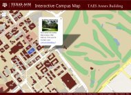
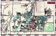
TEXAS A&M UNIVERSITY RIVERSIDE CAMPUS PLAN40FIGURE 1Hangar T-46 (7046), ca. 1955.FIGURE 2Hangar T-90 (7090), ca. 1951.FIGURE 3Facing page: Map <strong>of</strong> <strong>Riverside</strong>campus showing structures anddate <strong>of</strong> construction, August2012, from <strong>Office</strong> <strong>of</strong> <strong>Facilities</strong><strong>Coordination</strong>.SECURITY AND VISIBILITYThe issue <strong>of</strong> ‘branding’ and identification <strong>of</strong> the<strong>Riverside</strong> <strong>Campus</strong> as an integral part <strong>of</strong> <strong>Texas</strong>A&M University will attract a greater number<strong>of</strong> visitors, and a balance will need to be foundbetween greater accessibility and the provision <strong>of</strong>needed security and safety. The plan suggests theconstruction <strong>of</strong> an administrative infrastructurethat will issue visitor passes, provide police andfire protection on a 24-hour basis, and introducediscrete areas <strong>of</strong> security and access based on theactivities in each area. Boundaries will reflectlife safety issues and the control <strong>of</strong> access to areaswith operational security requirements. Entitieswith greater security needs should anticipateincreased costs associated with a greater level <strong>of</strong>protection.MILITARY HERITAGE DISTRICTTo the greatest extent possible buildings in theMilitary Heritage District area constructed between1942 and 1957 shall be protected and rehabilitatedto serve existing and future uses, whileretaining their original character.The Military Heritage District overlays the DevelopmentZones and extends from 200 feet east<strong>of</strong> Bryan Road; 300 feet north <strong>of</strong> 5th Street to 1001 2feet west <strong>of</strong> the apron at Flight Line Road; 300The need for new structures in this area, or thefeet south <strong>of</strong> 6th Street, down to Avenue A, and decision to replace an existing structure, shall bethen contains half the block between 6th and 7th predicated on preserving the visual integrity <strong>of</strong>Streets. Existing buildings within this area should the ‘base’ context. As such, the location <strong>of</strong> newbe considered for preservation and re-use, specificallythe Chapel (7006), the Control Tower struc-previously existed, and the scale and general ap-buildings will follow locations <strong>of</strong> buildings thatture (7077) and Hangar T-46 (7046.) Any new pearance <strong>of</strong> the new structures will be compatibleconstruction in this area should respect the scale, with, but not copies <strong>of</strong>, the original buildings.massing and material selection that reflects thehistoric nature <strong>of</strong> the base.The design review process will pay special attentionto the overall and immediate context <strong>of</strong> eachEvery effort should be made to find a use for HangarT-46 that supports the restoration approach but not limited to, paving, entry and exit, andbuilding historically and functionally, including,used for Hangar 7090 (TTI), celebrates the militaryhistory <strong>of</strong> the campus, and incorporates the time.landscape treatments as they have developed overstructure <strong>of</strong> the Control Tower as part <strong>of</strong> the interpretation.