Riverside Campus Plan - Office of Facilities Coordination - Texas ...
Riverside Campus Plan - Office of Facilities Coordination - Texas ...
Riverside Campus Plan - Office of Facilities Coordination - Texas ...
- No tags were found...

You also want an ePaper? Increase the reach of your titles
YUMPU automatically turns print PDFs into web optimized ePapers that Google loves.
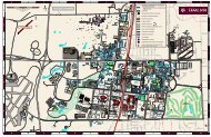
CURRENT CONDITIONSIII. CURRENT CONDITIONS17LAND AND FACILITIES USESented northeast-southwest to follow a rail spurFIGURE 12The <strong>Riverside</strong> <strong>Campus</strong> comprises some 2,000acres <strong>of</strong> land, <strong>of</strong> which 869 acres are used forpasture or open fields, and 207 acres are concreterunways, taxiways and aprons.There are over one hundred buildings, ranging inage from 68 years to two currently under construction.There are approximately 750,000 grosssquare feet <strong>of</strong> buildings, with 66% <strong>of</strong> that beingassignable, though in a wide range <strong>of</strong> physicalcondition.that served a series <strong>of</strong> storage buildings alongWarehouse Road and maintenance facilities along2nd Street. The other cross streets are spaced unevenlyin an east-west configuration, and identifiedas 3rd through 8th Streets.The 1942 base had three 300 feet x 5,000 feetrunways in the classic delta layout. Two northsouthrunways intersecting the delta, each 150feet x 7,000 feet, were added during the Koreanconflict.Facing page: <strong>Riverside</strong> <strong>Campus</strong>map <strong>of</strong> land use, 2012, <strong>Office</strong><strong>of</strong> <strong>Facilities</strong> <strong>Coordination</strong>.FIGURE 2Old entrance <strong>of</strong>f HWY 21 toBryan AFB, ca. 1957.FIGURE 3Intersection <strong>of</strong> Seventh Streetand Avenue B, showing barditches and poor road conditions.Forty-five <strong>Texas</strong> A&M University departmentsutilize space at <strong>Riverside</strong>, as do five <strong>Texas</strong> A&MUniversity System units and one Federal agency.The construction <strong>of</strong> Highway 47 cut the accessfrom Bryan Road to Highway 21, and a new entranceroad was created to link Highway 47 to5th Street.CIVIC FABRIC EVALUATIONThe road system is in very poor condition, with3The overall layout at the <strong>Riverside</strong> <strong>Campus</strong> wasestablished by the Army Air Force in 1942. Theaccess to the base at that time was from Highway21, and entered on a north-south road identifiedas Bryan Road. The grid road system paralleledBryan Road with Avenues A, B, C, and D, withthe last road established along the apron andonly minimum maintenance having been undertakenover the years. 5th Street has been resurfacedfrom New Entrance Road to Flight LineRoad, but road widths remain at 20 feet. Thedrainage uses the bar ditch method, and while thebar ditches have been maintained, the majority <strong>of</strong>the culverts are at least partially obstructed.known as Flight Line Road.As new facilities have been added by state agen-The first streets at the north <strong>of</strong> the base were ori-cies some paved parking has been introduced,