

Glendale (PDF) - Hazard Mitigation Web Portal - State of California
Glendale (PDF) - Hazard Mitigation Web Portal - State of California
Glendale (PDF) - Hazard Mitigation Web Portal - State of California
- No tags were found...

You also want an ePaper? Increase the reach of your titles
YUMPU automatically turns print PDFs into web optimized ePapers that Google loves.
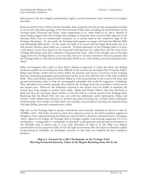
Natural <strong>Hazard</strong>s <strong>Mitigation</strong> PlanCity <strong>of</strong> <strong>Glendale</strong>, <strong>California</strong>Section 6 – Earthquakesfault poses to the Los Angeles metropolitan region, several researchers have started to investigatethis fault.Some researchers have relied on deep subsurface data, primarily oil well records and geophysical datato review the subsurface geology <strong>of</strong> the San Fernando Valley area, including the characteristics <strong>of</strong> theVerdugo fault (Tsutsumi and Yeats, 1999; Langenheim et al., 2000; Pujol et al., 2001). Results <strong>of</strong>these studies suggest that the Verdugo fault changes in character from a reverse fault adjacent to thePacoima Hills, near its northwestern terminus, to a normal fault at the southwest edge <strong>of</strong> theVerdugo Mountains. To the north, the Verdugo fault appears to merge with both the Mission Hillsand Northridge Hills faults. To the south, the fault is on trend with the Eagle Rock fault, but it isstill unclear whether these faults are connected. Vertical separation on the Verdugo fault is at least1,000 meters (3,300 feet), based on the structural relief between the valley floor and the crest <strong>of</strong> theVerdugo Mountains and other indicators (Tsutsumi and Yeats, 1999). Even though some <strong>of</strong> the datasuggest that the Verdugo fault is a reverse fault, there are several researchers who now propose thatthe Verdugo fault is a left-lateral strike-slip fault (Walls et al., 1998; Dolan, personal communication,2002).Other investigators have taken a more direct, hands-on approach to study this fault, but findinglocations suitable for trenching has been difficult in the extensively developed San Fernando Valley.Dolan and Tucker (1999) tried to better define the location and recency <strong>of</strong> activity <strong>of</strong> the Verdug<strong>of</strong>ault by conducting geological and geophysical studies across the inferred trace <strong>of</strong> the fault in BrandPark. They used closely spaced boreholes drilled in a line perpendicular to the trend <strong>of</strong> the fault, andground penetrating radar to look for stratigraphic anomalies that could be suggestive <strong>of</strong> faulting.They identified one possible anomaly that could be the Verdugo fault and excavated a trench acrossthe suspect area. However, the sediments exposed in the trench were too friable to maintain thetrench open long enough to conduct their study. Dolan and Tucker believe that they did locate afault, but they are uncertain about whether or not the fault is a recent strand <strong>of</strong> the Verdugo fault.Realizing that the Brand Park site may not yield any additional, useful information, Dolan andTucker (1999) shifted their attention to another potential trenching site, at Palm Park in Burbank.Unfortunately, their studies at Palm Park were equally unsuccessful at locating and characterizingthis fault (Dolan, personal communication, 2002).Slip rate on the Verdugo fault is poorly constrained, and currently estimated at about 0.5 mm/yr(CDMG, 1996). The fault’s recurrence interval is unknown; however, the fault’s southern segment isthought to have ruptured during the Holocene, and the fault is therefore considered active (Jennings,1994). Based on its length, the Verdugo fault is thought capable <strong>of</strong> generating magnitude 6.0 to 6.8earthquakes. A magnitude 6.7 earthquake on this fault would generate peak ground accelerations inthe <strong>Glendale</strong> area <strong>of</strong> about 0.6g to 0.7g, with intensities as high as X (see Map 6.4). Higheraccelerations can be expected locally. Given the high accelerations that this fault is estimated capable<strong>of</strong> generating in <strong>Glendale</strong>, an earthquake scenario on this fault was modeled for loss estimationpurposes.Map 6.4: Scenario for a M6.7 Earthquake on the Verdugo FaultShowing Estimated Intensity Values in the Region Resulting from this Event2006 PAGE 6 - 21


