NGWAKETSE LAND BOARD LAND ALLOCATION POLICIES
NGWAKETSE LAND BOARD LAND ALLOCATION POLICIES
NGWAKETSE LAND BOARD LAND ALLOCATION POLICIES
- No tags were found...

Create successful ePaper yourself
Turn your PDF publications into a flip-book with our unique Google optimized e-Paper software.
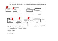
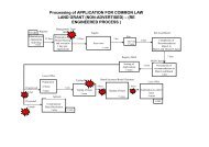
adjacent to the plot is unusable except for the purpose sought by the applicant.4.0 AGRICULTURAL HOLDINGS AND OTHER SECTORS‣ The Land Board shall plan for all agricultural holdings of ranging sizes to accommodate usessuch as small stock. Feedlots. Dairy farms e.t.c.‣ Sizes shall be determined by planning standards and Agricultural Guidelines in force fromtime to time.5.0 ADVERTISEMENTS‣ Planned Commercial/Industrial/ Civic and Community and agricultural plots shall be advertisednationally.‣ Plots proposed or planned for government institutions, utility providers, parastatals and criticaldevelopers shall not be subjected to advertisement and competition.6.0 INHERITANCE AND REGISTRATION OF RIGHTSIn order to regularize inheritance claims and old allocations without certificates the following will berequired;‣ Letter from Kgosi/administrative/legal authority confirming previous allocation and/or inheritance.‣ Letter from other parties/ relatives confirming previous allocation and/or inheritance.‣ Further independent evaluation by the Land Board.‣ All registration of old rights shall be registered or allocated a maximum of the prevalent plot sizesunless where it is evident the whole land is being utilised.‣ All unregistered allocations should be registered within two years of adoption of these policiesfailing which the rights shall be automatically forfeited to the Land Board.To increase by further 1 year for registration of rights7.0 <strong>ALLOCATION</strong> OF SURFACE RIGHTSApplicants for gravel, quarrying and other mining related activities shall be required to submit the following;Requirements for surface rights application‣ Common Law application Form‣ Certificate of Incorporation if the applicant is a company.‣ A locality sketch plan (preferably with coordinates) showing the proposed site.‣ For contractor, a letter of award of the said project, stating its duration and nature.‣ Written proof of Community consultations‣ The Land Board will issue a conditional offer requiring the following:
‣ Submit clearance letter from Department of Mines justifying satisfactory rehabilitation of previousburrow pit8.0 BUFFER ZONESBuffer Zones are not strictly free zones. They are a form of land use in which compatible land uses may beconsidered by the Land Board on the basis of merit.8.1 Distance between Liquor Outlets and Residential/Civic and Community Plots‣ The buffer zone between liquor outlets and roads, civic/community plots shall be 500 metres.‣ The buffer zone between liquor outlets and residential plots shall be 50 metres‣ Or as directed by the `Minister of Trade and Industry.8.2 Allocation free zone from rivers and Streams‣ 50 metres for streams‣ 100 metres for rivers.‣ Tourism related activities whose location is proposed within the buffer zone require to be justifiedby the submission of a detailed Management Plan and EIA8.3 Water point to Wildlife Management AreasBuffer zone to Wildlife Management Area shall be a minimum of 500m.9.0 WATER POINTSThere shall be a distinction on the following;9.1 Livestock water pointThis is any place where livestock is watered. It includes Boreholes, wells, perennial pans, bowsing andreticulation points.9.2 Water SourceThis is any point where water is sourced from.9.3 ReticulationThis is networking of two points for transportation of water by pipeline.‣ An applicant shall be allocated only one water point in Tribal Land‣ Water points shall be allocated at distances of 6 kilometres from each other.‣ Any water point below 6 km and above 5 kilometres shall be subjected to range assessment.
‣ Any water point below 5 km shall not be considered.‣ Once a proposed livestock water point has been determined as unsuitable for allocation, (eitherthrough inadequate distances or range ecologist report), the Board may no longer consider thepoint for allocation to any other person.‣ Applicants shall be allowed to make a relief water point within 1 km of their allocated point but shallbe required to reticulate back to their allocated water point. Prior approval for relief water pointsshall be sought from the Land Board.‣ For existing water points whose distribution is within 1Km, prior approval for relief water points shallbe sought from the Land Board.‣ Where feasible, an applicant shall be allocated a water source at any place but shall be required toreticulate back to their allocated water point.‣ For government water source, preference may be given to those whose water points are in closeproximity.‣ Reticulation shall only be allowed where an applicant has an allocated water point.‣ Members of Syndicates shall not be given priority when they apply for other water points. Theyshall only be considered for a point on condition that they relinquish their rights from the Syndicate.9.4 Allocations around livestock water pointsNo allocation shall be allowed within 3 kilometres of livestock water point/borehole with the exception forclause 2.3.1 and 2.3.39.5 Water Points within Arable Fields‣ People shall have the right to apply boreholes within the confinement of the ploughing fieldallocated to them by the Land Board/registered by the Land Board.‣ No water points shall be allocated within protected well fields.9.6 Livestock within Arable Fields‣ Total number of livestock shall be limited to 12 cattle, 20 smallstock and shall be kraaled inside thearable field.‣ Livestock listed above shall be the ones permitted to be watered in the field borehole.9.7 Other water pointsWater points for agricultural projects/highway shops shall be allocated within the project area.10.0 DISTANCES BETWEEN WATER POINTS AND OTHER <strong>LAND</strong> USES10.1 Distance between Water points and other features
A minimum distance of 2 kilometres shall be observed. The buffer here is meant for disease controlpurposes and also to create some grazing space on either side of the water point. These features includeroads, ranches and drift fences. Consider expending features to include others like interstate boundaries.10.2 Water point to Villages/Settlements‣ A minimum distance of 15km from Villages/settlements shall be observed for allocation of waterpoint to allow for future village expansion, communal grazing, arable requirements and collection ofveld products.10.3 Ranches to Villages/Settlements‣ For ranch development, a minimum of 20km buffer zone shall be observed.11.0 REQUIREMENTS FOR TOURIST RELATED ACTIVITIESTourist related land use shall be identified, planned and advertised.12.0 MATLOTLANo claim shall be entertained in respect of a letlotla allocated by Kgosi/Land Board or self and not usedover a minimum period of 10 years.13.0 CEMETERIES‣ Deceased persons shall be buried at designated cemeteries. These are cemeteries which shallhave been identified in consultation with Tribal Authority, the Village DevelopmentCommittee/District Council and the Land Board and/or zoned as such by the Village DevelopmentPlan.‣ Land reserves around deceased loved ones shall not be allowed.14.0 CUSTOMARY <strong>LAND</strong> RIGHTSThere shall be no conversion of boreholes, ditlaagana or masaka to common law.15.0 INTEGRATED <strong>LAND</strong> USEWhere land use is integrated, the Land Board shall allow people to practice mixed farming.
16.0 Effective date of these Policies is 1 st April 2011.SIGNED…………..G.E. RaditladiBoard SecretaryDate ……………………….K.E. MahlakaBoard ChairmanDate …………….