LANDSLIDES HAZARDS ZONATION MAP OF INDIA ... - South Sikkim
LANDSLIDES HAZARDS ZONATION MAP OF INDIA ... - South Sikkim LANDSLIDES HAZARDS ZONATION MAP OF INDIA ... - South Sikkim
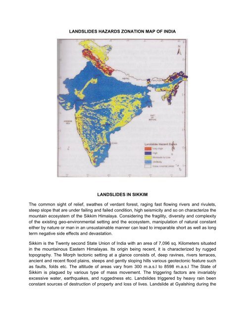
LANDSLIDES HAZARDS ZONATION MAP OF INDIALANDSLIDES IN SIKKIMThe common sight of relief, swathes of verdant forest, raging fast flowing rivers and rivulets,steep slope that are under failing and failed condition, high seismicity and so on characterize themountain ecosystem of the Sikkim Himalaya. Considering the fragility, diversity and complexityof the existing geo-environmental setting and the ecosystem, manipulation of natural constanteither by nature or man in an unsustainable manner can lead to irreparable short as well as longterm negative side effects and devastation.Sikkim is the Twenty second State Union of India with an area of 7,096 sq. Kilometers situatedin the mountainous Eastern Himalayas. Its origin being recent, it is characterized by ruggedtopography. The Morph tectonic setting at a glance consists of, deep ravines, rivers terraces,ancient and recent flood plains, steeps and gently sloping hills various geotectonic feature suchas faults, folds etc. The altitude of areas vary from 300 m.a.s.l to 8598 m.a.s.l The State ofSikkim is plagued by various type of mass movement. The triggering factors are invariablyexcessive water, earthquakes, and ruggedness etc. Landslides triggered by heavy rain beenconstant sources of destruction of property and loss of lives. Landslide at Gyalshing during the
- Page 2 and 3: third and last week of August 2000
- Page 4 and 5: phenomena are not perfectly repeata
- Page 6 and 7: GEOLOGY AND TECTONICSMillets (1875)
- Page 8 and 9: Types of movementType of materialBe
- Page 10 and 11: RAINFALL AS A TRIGGERIn the majorit
- Page 12 and 13: Considerable efforts have been made
- Page 14 and 15: Sealing of the header or the top pa
- Page 16 and 17: Controlled demolition is based on t
- Page 18 and 19: details were added. In Sikkim Himal
- Page 20 and 21: Rangit vally ha seen as a place of
- Page 22 and 23: edded Phyllites / quartzite followe
- Page 24 and 25: ed soil overburden mass. The slide
- Page 26 and 27: sweelwhen saturated with water and
- Page 28 and 29: Nalas. Whole part of the area of Ma
- Page 30 and 31: low grade metaphorphic rock of Dali
- Page 32 and 33: ocks slide down as avalanche as a r
- Page 34 and 35: further subject to grouting and roc
<strong>LANDSLIDES</strong> <strong>HAZARDS</strong> <strong>ZONATION</strong> <strong>MAP</strong> <strong>OF</strong> <strong>INDIA</strong><strong>LANDSLIDES</strong> IN SIKKIMThe common sight of relief, swathes of verdant forest, raging fast flowing rivers and rivulets,steep slope that are under failing and failed condition, high seismicity and so on characterize themountain ecosystem of the <strong>Sikkim</strong> Himalaya. Considering the fragility, diversity and complexityof the existing geo-environmental setting and the ecosystem, manipulation of natural constanteither by nature or man in an unsustainable manner can lead to irreparable short as well as longterm negative side effects and devastation.<strong>Sikkim</strong> is the Twenty second State Union of India with an area of 7,096 sq. Kilometers situatedin the mountainous Eastern Himalayas. Its origin being recent, it is characterized by ruggedtopography. The Morph tectonic setting at a glance consists of, deep ravines, rivers terraces,ancient and recent flood plains, steeps and gently sloping hills various geotectonic feature suchas faults, folds etc. The altitude of areas vary from 300 m.a.s.l to 8598 m.a.s.l The State of<strong>Sikkim</strong> is plagued by various type of mass movement. The triggering factors are invariablyexcessive water, earthquakes, and ruggedness etc. Landslides triggered by heavy rain beenconstant sources of destruction of property and loss of lives. Landslide at Gyalshing during the
third and last week of August 2000 claimed eleven lives. Dormant as well as active slides arethreat to human life and property. Their study and monitoring has become imperative tosafeguard against destruction by them. Developmental activities to be sustainable must beconfined away from landslides prone and landslide affected locations Meyong Chub in North<strong>Sikkim</strong> is a glaring example.The <strong>Sikkim</strong> Himalaya has never been and will never be free from ubiquity of weak geology,slope instability, frequent seismicity, soil erosion etc. mainly due to natural causes and partly asa result of accelerated degradation. These adverse conditions in tandem can exacerbate theexisting fragile, vulnerable and multi-functional mountain ecosystem. So far disaster caused bylandslides, earthquake, flood etc. have not led to large scale human tragedy in <strong>Sikkim</strong> recentmemory. However, there is ever increasing human demand of natural resources, especially landfor urban development and mega dams in an apparently unsustainable manner, making someof the denizens to adapt and survive at dangerous margins. The emerging crisis can beminimized by indigenous knowledge based and modern technological interventions. Tosafeguard against accelerated degradation and improve the living standard of hill people, theGovernment (center and state) needs to address hill specific issues through systematic andaffective integration of the ecosystem service and development, highland and lowland linkagesetc. Without a replicable and hill specific development policy, the ever present threat formdevastating landslides, earthquake, flood etc. remains an option and opportunities of theprogeny in jeopardy. A beginning has been made by the state Government of <strong>Sikkim</strong> by askingthe Department of Science & Technology (DST), Government of India to undertake systemicstudy of landslide problems in the State. The DST accordingly prepared a status report onlandslide in <strong>Sikkim</strong>. Base on the report, the DST, Government of India, is consideringestablishment of a multi-disciplinary cell dedicated to landslide studies, not only in <strong>Sikkim</strong> butthe entire Northeastern State. Such an initiative has become imperative because pastexperience shows that different agencies carry out landslide studies at will land and withoutcoordination with each other. Results of such exercise never actually got disseminated andproved futile. Whereas the seismicity monitoring is concerned, site response studies usingdigital accelographs located at seven – station –strong motions network in <strong>Sikkim</strong> by year 2000and twelve –station network by year 2006 has been done by IIT, Kharagpur and study resultswidely published. Mass wasting processes area universal phenomena in mountain, hill and hillyareas of the world. Their magnitude, frequency and type differ from place to place and on thematerial that is undergoing displacement either through chemical or mechanical means. In theHimalayas, mass wasting process is dominated by landslides. The magnitude, intensity andfrequency of Himalayan landslides vary from East to West and from <strong>South</strong> to North. Thevariation is controlled, mainly by climate, neo-tectonism and seismicity. The eastern Himalayaincluding <strong>Sikkim</strong> is a hot-spot for natural hazards, particularly landslides and earthquakes.Landslides of all types and size occur in almost all types of rocks and quaternary formations of<strong>Sikkim</strong>. The Daling Group of rocks, especially, Goribathan Formation appears more prone tolandslides then the inhomogeneous quaternary deposits and gneisses and schist of HigherHimalaya. The high landslide susceptibility of the Daling Group of rocks has been attributed totheir severe shear distortion due to loading and unloading during or genesis, higher rate ofweathering and mineral composition. A cursory survey of frequency of occurrence of landslides
in <strong>Sikkim</strong> was done in 1991 and result clearly showed that the East and <strong>South</strong> District whereDaling rocks dominate are affected by maximum number of landslides (Table no 13). Landslidesare common phenomenon in a mountainous area having high relief. Landslides and other typesof mass movements have always attracted the attention of human in the same way as otheruncontrollable phenomenon of natural disaster like earthquakes, volcanoes and floods, whichthreaten the life and property of inhabitants. In some areas, the occurrence of landslides orother types of mass movements are less, but in a mountainous region with higher reliefaccompanied by tectonic activities as in <strong>Sikkim</strong>, various shapes or types of mass movementscan take up disastrous turn at times. The mountain slope are governed by laws of gravity andwith the forces of lubricant like water, the unstable slope-forming material shall continue to movedownwards and cause economic loss in terms of life and property. Landslide with heavy rainfallcauses flash floods in the valleys. Landslides or mass movement phenomena in a mountainousstate like <strong>Sikkim</strong> lying over the young mountain chain can be attributed to the followingcausative factors solely or in combination with:1. Geology of the area.2. Geo-technical condition.3. Rainfall.4. Slope angle and slope formation materials.5. Hydrological condition of the area.Rainfall particularly in the <strong>Sikkim</strong> Himalaya is often punctuated by flashes of cloudburst. Acloudburst comes with the speed of thunder, lasts for a few minutes to as long as threehours at stretch of time, and usually leaves behind a trial of devastation worse than inflictedby the combined effect of rainfall in the same area, for the rest of the season. Rainfall recordof the Teesta Valley for the period 1891-1965 speaks of rainfall intensities exceeding 250mm in 24 hours, repeated more than 40 times! Taking the mean annual precipitation as5000 mm for the Teesta Valley, the Event Coefficient (Ce =precipitation record of theevent/mean annual precipitation) can be calculated. Thus, event coefficients (Ce) do rangebetween 0.069 and 0.36, which are remarkably high values from any standards and areusually associated with landslides’ on the lower side of the scale and landslide disasters onthe higher side of the scale. Admittedly, conclusions derived from study of ‘eventcoefficients’ alone, without cognizance of rainfall records prior to the event and withoutknowledge of landslide history of the area may be deceptive. However, the fact remains that‘cloud bursts’ of intensities exceeding 1000mm in 24 hours (Ce>0.2) trigger massmovements practically in any circumstances, and for 0.1
phenomena are not perfectly repeatable; usually being characterized by different causes,movements and morphology, and involving genetically different material. For this reason,landslide classifications are based on different discriminating factor, sometimes verysubjective.In the following, factors are discussed by diving them into two groups:(A) The first one is made up of the criteria utilized in the most widespread classificationsystems that can generally be easily determined.(B) The second one is formed by those factors that have been utilized in someclassifications and can be useful in description.Types of movementThis is the most important criteria, even if uncertainties and difficulties can arise in theidentification of movements, being the mechanisms of some landslides often particularlycomplex. The main movements are falls, slides and flows, but usually topples, lateralspreading and complex movements are added to these.Material InvolvedRock, earth and debris are the terms generally used to distinguish the material involvedin the landslide process. For example, the distinction between earth and debris id usuallymade by comparing the percentage of coarse grain size fraction. If the weight of theparticles with a diameter greater than 2mm is less than 20%, the material will be definedas earth; in the opposite case, it is debris.ActivityThe classification of a landslide based on its activity is particularly relevant in theevaluation of future events. The recommendation of the WP/WLI (1993) defines theconcept of activity with reference to the spatial and temporal conditions, defining thestate, the distribution and the style. The first term describes the information regarding thetime in which the movement took place, permitting information to be available on thefuture evolution, the second term describes, in a general way, where the landslide ismoving and the third term indicates how it is moving.Movement velocityThis factor has a great importance in the hazard evaluation. A velocity range isconnected to the different types of landslides, on the basis of observation of case historyor site observations.
The age of the movementLandslide dating is an interesting topic in the evaluation of hazard. The knowledge of theLandslide frequency is a fundamental element for any kind of probabilistic evaluation.Furthermore, the evaluation of the age of the landslide permits to correlate the trigger tospecific conditions as earthquakes or periods of intense rains. It should be noted that, itis possible that phenomena could be occurred in past geological times, under specificenvironmental conditions which no longer act as agents today. For example, in someAlpine areas landslides of the Pleistocene age are connected with particular tectonic,geomorphologic and climatic conditions.Geological conditionsThese represent a fundamental factor of the morphological evolution of a slope. Beddingaltitude and the presence of discontinuous or faults control the slope morphogenesis.Morphological CharacteristicsAs the landslide is a geological volume with a hidden side, morphological characteristicsare extremely important in the reconstruction of the technical model.Geographical locationThese criterions describe, in a general way, the location of landslides in thephysiographic context of the area. Some authors have therefore identified landslideaccording to their geographical position so that it is possible to describe “alpinelandslides”, “landslides in plains”, “hilly landslides” or “cliff landslides”. As aconsequence, specific morphological context are referred characterized by slopeevolution processes.Topographical criteriaWith these criteria, landslides can be identified with a system similar to that of thedenomination of formations. Consequently, it is possible to describe a landslide usingthe name of a site in particular, the name will be that of the locality where the landslidehappened with a specific characteristic type.Type of climateThese criteria give particular importance in the genesis of phenomena for which similargeological condition can, in different climatic conditions, lead to totally differentmorphological evolution. As a consequence, in the description of a landslide, it can beinteresting to understand in what type of climate the event occurred.
GEOLOGY AND TECTONICSMillets (1875) & Bose (1891) were the first explorers who gave an account of geologyand mineral resources of <strong>Sikkim</strong> Himalaya. Subsequent exploration by Auden (11935),Heim and Gansser5 (1939), Ray (1947), Gosh (1952), Raina and Srivastava (1980),Thakur (1986), Ravikant (1993), Neogietal (1989), Ray (2000) and others gave importantand valuable contributions towards understanding of geology of <strong>Sikkim</strong>.The current literature describe geology of <strong>Sikkim</strong> similar to that of the Eastern Himalayaswhere four, distinct geomorphology based transverse zone or tectonic stratigraphicdomains, separated by major tectonic dislocation, are exposed in <strong>Sikkim</strong>. The Lesser,Higher and Tethys Himalaya of <strong>Sikkim</strong> are typically arranged in a domal shape or arch ofthrust surface in the form of culmination across Teesta river, popularly known as Teestaculmination (Mcclay, 1992, Ray, 2000). The core of the Teesta culmination is occupiedby Proterozoic Lesser and Higher Himalaya crystalline complex, the main central Thrust(MCT) separates the lesser and Higher Himalaya. Gondovana (carboniferous topermain) and Buxa Group of rocks are exposed in the Rangit window Zone, smallwindow near Rorathang east <strong>Sikkim</strong> and as thrust / fault slices in <strong>South</strong> <strong>Sikkim</strong>. TheTethys Himalaya is represented by cambrain to Eocene fossilferous sediments of North<strong>Sikkim</strong> Tethyan Zone which tectonically overlie the Higher Crystalline Complex (see mapbelow).CAUSE <strong>OF</strong> MOVEMENTSTerzagi describes causes as “internal” and “external” referring to modification in theconditions of the stability of the bodies. Whilst the internal modifications in the materialitself which decreases its resistance to shear stress, the external causes generallyinduce an increase of sheer stress, so that block or bodies are no longer stable. It shouldbe noted that the triggering causes induce the movement of the mass. Predisposition tomovement due to control factors is determining in landslide evolution. Structural andgeological factors, as already described, can determine the development of themovement, inducing the presence of mass in kinematic freedom.
Geology and Stratigraphy of <strong>Sikkim</strong> (from CCSTB,CISMHE)TYPE AND CLASSIFICATIONIn the following table shows a schematic landslide classification adopting theclassification of Varnes 1978 and taking into account the modifications made by Crudenand Varnes, in 1996. Some integration has been made by using the definitions ofHutchinson (1988) and Hungretal 2001.
Types of movementType of materialBedrock Engineering soilsPredominantlyFinePredominantlycoarseFallsRock fall Earth fall Debris fallTopplesRock topple Earth topple Debris toppleSlides Rotational Rock slump Earth slump Debris slumpFew units Earth block Earth block Debris blockTranslationalslidesideslideManyunits Rock slide Earth slide Debris slideLateral spreads Rock spread Earth spread Debris spreadFlowsRock flow Earth Flow Debris flowComplex and compoundRockDebris avalancheavalanche(Deep creep)(Soil creep)Combination in time and /or space of two or morePrincipal types of movement.CAUSE <strong>OF</strong> <strong>LANDSLIDES</strong>Causes may be considered to be factors that made the slope vulnerable to failure, thatpredispose the slope to becoming unstable. The trigger is the single events that finallyinitiate the landslide. Thus, causes combine to make a slope vulnerable to failure, whilstthe trigger finally initiates the movement. Landslide can have many causes, but can onlyhave one trigger as shown in the next figure. Usually, it is relatively easy to determinethe trigger after the landslide has occurred (although it is generally very difficult todetermine the exact nature of landslide triggers ahead of a movement event).1. Geological Factorsa. Weak materialsb. Sensitive materialsc. Weathered materialsd. Sheared materialse. Jointed or fissured materialsf. Adversely oriented discontinuitiesg. Permeability contrastsh. Material contrasts2. Morphological causesa. Slope angleb. Uplift
c. Reboundd. Fluvial erosione. Wave erosionf. Glacial erosiong. Erosion of lateral marginsh. Subterranean erosioni. Slope loadingj. Vegetation change3. Physical causesa. Intense rainfallb. Rapid snow meltc. Prolonged precipitationd. Rapid drawdowne. Earthquakef. Volcanic eruptiong. Thawingh. Freeze-thawi. Shrink-swellj. Ground water changesk. Other mass movements4. Human causesa. Excavationb. Loadingc. Drawdownd. Land use changee. Water managementf. Miningg. Quarryingh. Vibrationi. Water leakageExample of landslide causation and triggeringCAUSESSteep slope angleWeak rocksFaultEarlier earthquakeUndercuttingTRIGGERRainfallEFFECTLandslide
RAINFALL AS A TRIGGERIn the majority of cases, the main trigger of landslides is heavy or prolonged rainfall. Generally,this takes the form of either an exceptional short lived event, such as the passage of a tropicalcyclone or even the rainfall associated with a particularly intense thunderstorm or of a longduration rainfall event with lower intensity, such as the cumulative effect of monsoon rainfall in<strong>South</strong> Asia. In the former case, it is usually necessary to have very high rainfall intensities,whereas in the latter the intensity of rainfall may be only moderate- it is he duration and existingpore water pressure conditions that are important. The importance of rainfall as a trigger forlandslides cannot be under-estimated. Almost all the landslides in <strong>Sikkim</strong> occur after prolongedexposure to monsoon rains and occasionally during or just after cloudburst or precipitationintensity exceeding 135-145 mm in 24 hours.The red letter of October 1968 was considered the most disastrous in recent years of <strong>Sikkim</strong>history. On 5 th September 1995 heavy rain triggered off a mud avalanche near Gangtok killing32 people. Similarly, non-stop heavy rain since early June 1997 damaged 300 housescompletely, 1000 houses partially and caused death of 51 people in east and North District ofthe state. Rain, therefore, has been one of the main triggers besides weak geology; steepslopes with thick overburden, frequent earthquake etc., and causing landslides (refer tableno.37). So why does the rainfall trigger so many landslides? Principally, this is because therainfall drives an increase in pore water pressure within the soil.The figure A illustrates the forces acting on an unstable block on a slope. Movement is driven bysheer stress, which is generated by the mass of the block acting under gravity down the slope.Resistance to movement is the result of the normal load. When the slope fills with water, thefluid pressure provides the block with buoyancy, reducing the resistance to movement. Inaddition, some cases fluid pressures can act down the slope as a result of groundwater flow toprovide a hydraulic push to the landslide that further decreases the stability. Whilst the examplegiven in figure A and B is clearly an artificial situation, the mechanics are essentially as per areal landslide.
Movement driven by landslidemass acting through gravitydown slopeUnstableblockResistance to movementfrom normal forceA: Diagram illustrating the resistance to, and cause of, movement in a slope system consisting of anunstable block.Shear force are unchangedor slightly increasedAdditionalhydraulic pushUnstableBlockWaterB: Diagram illustrating the resistance to, and causes of movement in a slope system consisting of anunstable block.In some situations, the presence of high levels of fluid may destabilize the slope through othermechanism, such as:• Fluidization of debris from earlier events to form debris flows.• Loss of suction forces in silty materials, leading to generally shallow failures (this may bean important mechanism in residual soils in tropical areas following deforestation).• Undercutting of the toe of the slope through river erosion.
Considerable efforts have been made to understand the triggers for land sliding in naturalsystems, with quite variable results. For example, geologist is Puerto Rico, Larsen and Simonfound that storms with a total precipitation of 100-200 mm, about 14 mm of rain per hour forseveral hours, or 2-3 mm of rain per hour for about 100 hours can trigger landslides in thatenvironment. Rafi Ahmad, working in Jamaica, found that for rainfall of short duration (about 1hour) intensities of greater than 36 mm/h were required to trigger landslides. On the other hand,for long rainfall durations, low average intensities of about 3mm/h appeared to be sufficient tocause landslide as the storm duration approaches approximately 100 hours. Coro minas andMoya (1999) found that the following threshold exist for the upper basin of the Llobregat River,Eastern Pyrenees area. Without antecedent rainfall, high intensity and short duration rainstriggered debris flows and shallow slides developed in colluviums and weathered rocks. Arainfall threshold of around 190 mm in 24 h initiated failures whereas more than 300 mm in 24 -48 h were needed to cause widespread shallow landslide. With antecedent rain, moderateintensity precipitation of at least 40 mm in 24 h reactivated mudslide and both rational andtranslation slides affecting clayey and silty-clayey formations. In this case, several weeks and200 mm of precipitation were needed to cause landslide reactivation. A similar approach isreported by Brand et al. (1988) for Hong Kong, who found that if the 24 hour antecedent rainfallexceeded 200 mm then the rainfall threshold for a large landslide event Was 70 mm hr -1.Finally, Caine (1980) established a worldwide threshold:I =14.82 D – 0.39 where: I is the rainfall intensity (mm h-1), D is the duration of rainfall (h)This threshold applies over time periods of 10 minutes to 10 days. It is possible to modify theformula to take into consideration areas with high mean annual precipitations by considering theproportion of mean annual precipitation represented by any individual event. Other techniquescan be used to try to understand rainfall triggers, including:• Actual rainfall techniques, in which measurement of rainfall are adjusted for potentialevaporation, transpiration and then correlated with landslide movement events.• Hydro geological balance approaches, in which pore water pressure response to rainfallis used to understand the conditions under which failures are initiated.• Coupled rainfall – stability analysis methods, in which pore water pressure responsemodels are coupled to slope stability models to try to understand the complexity of thesystem.• Numerical slope modeling, in which finite element (or similar) models are used to try tounderstand the interaction of all relevant processes.
DIFFERENT MITIGATION MEASURES TAKEN FOR <strong>LANDSLIDES</strong>Installation of anchors anchors and nails on unstable rocky hillsideReinforcement measures generally consist of the introduction of metal elements whose purposeis to increase the shear strength of the rock and to reduce the stress release created, forexample, following cutting. Reinforcement measures are made up of metal rock nails oranchors. Anchorage can be classified as active anchorage, in the case in which they aresubjected to pre-tensioning, and passive anchorage.Passive anchorage can be used both to nail single unstable blocks and to reinforcelarge portions of rock. They can also be used as the pre-reinforcement elements of a scrap tobe re-profiled in order to limit hillside decompression associate with cutting. In an anchorage aredefined: the header : the set of elements (anchorage plate, blocking device, etc.) part of theanchor, concreted and otherwise, placed under traction; can be constituted by a metal rod, ametal cable, a strand, etc; the length of the foundation: the deepest portion of the anchor, fixedto the rock with chemical bonds or mechanical device, which transfer the load to the rock itself,the free length: the non- concreted length. When the anchorage acts over a short length it isdefine as bolt. It is, therefore, a specific type of anchorage, not structurally connected to thefree length, made up of an element resistant to traction, normally a steel bar of less than 12m,protected against corrosion by a concrete health. As far as the anchorage device to the groundis concerned, it can be chemical, or use mechanical expansion or concerting.In the first case, some polyester resin cartridges are placed in the perforation to fillthe ring space around the end part of the bolt. The main advantage of this type of anchoragelies in its simplicity and in the speed of installation. The main disadvantage is in its limitedstrength. In the second case, the anchorage is composed of steel wedges driven into the sidesof the hole. The advantage of this type of anchorage lies in the speed of installation and in thefact that the tensioning can be achieve in the instant the anchorage is put to work. The maindisadvantage with this type of anchorage is that it can only be used with hard rock. Moreover,the maximum traction force is limit.In the third case, the anchorage is obtained by concreting the whole metal bar: this isthe most- used method since the materials are cheap and installation is simple. Injectedconcrete the mixes can be used in many different rocks and ground; moreover, the concretesheath protects the bar from corrosion. The concrete mixture is generally made up of water andcement in the ratio W/C = 0.40-.45, since in this way a sufficient fluid mixture is obtained toallow pumping into the hole, while at the same time, when set, providing high mechanicalstrength. As far as the working mechanical of a rock nail is concerned, the strains of the rockinduce a stress state is the nail composed of shear and traction stress, due to the roughness ofthe joint, to their opening and to the direction of the nail, generally non-orthogonal to the jointitself. The execution phase of setting up the nail provides for:• Formation of any header niche and perforation.• Setting up of a reinforcement bar (e.g a 4-6 m long FeB44k bar).• Concrete injection of the bar.
Sealing of the header or the top part of the hole. It is, anyway, suitable to close up and cementany cracks in the rock to prevent pressure caused by water during the freeze-thaw cycles fromproducing progressive breaking in the reinforcement system set up. To this purpose, a produceris provided.1. Cleaning out and washing of the cracks.2. Plastering of the crack.3. Predisposition of the injection tubes at suitable inter-axes, parallel to the crack, throughwhich the concrete mix is injected.4. Sequential injection of the mixture from bottom to top and at low pressure (1-3 atm.) untilrefusal or until to flow back of the mixture is noted from the tubes placed higher up. Theinjection mixtures will have approximately the following composition.Cement – 10 kgWater -65 lFluidity and anti-shrinkage additive or bentonite – 1 to 5 kgSpriz –Beton (shot crete)As defined by the American Concrete Institute “Shot crete is mortar or concrete conveyedthrough a house and pneumatically projected at high velocity onto a surface. There are twodistinct processes of shot crete application: dry process and wet process. Often the term guniteis used, which refers exclusively to the dry process.DrainageThe presence of water within a rocky hillside is one of the major factors leading to instability.Knowledge of the water pressure and of the runoff mode is the basic for being able both to carryout credible stability analyses, and to plan measures aimed at improving hillside stability. Hoekand Bray (1981) provide a scheme of possible measures that can be actuated on a hillside toreduce not only the amount of water, which they believe in itself to be negligible as an instabilityfactor, but above all the pressure brought to bear by the water. The proposed scheme waselaborated taking three principles into account.• Preventing water entering the hillside through open or discontinuity traction cracks.• Reducing water pressure in the vicinity of potential breakage surfaces through selectiveshallow and sub-shallow drainage• Placing drainage in order to reduce water pressure in the immediate vicinity of thehillside.The measures that can be achieved to reduce the effects of water can be shallowor in depth. Shallow drainage work has the main function of intercepting surface runoffwater and keeping it away from potentially unstable areas. In reality, on rocky hillsides,this type of measures although contributing to reducing the amount of infiltration, alone issufficient to stabilize a hillside.
Deep DrainageDeep drainage is the most effective type of slope. Sub-horizontal drainage is very effective inreducing pore- pressure along crack surface or potential breakage surfaces. In rocks the choiceof drain spacing, slope, and length is subordinated to, apart from the hillside geometry, thestructural formation of the mass features such as position, spacing and discontinuity openingpersistence condition, apart from the mechanical characteristics of the rock, the water runoffmode inside the mass. Therefore, only by intercepting the mostly drained discontinuities canthere be an efficient result. The sub horizontal drains are accompanied by surface collectorswhich gather the water and take it away through networks of small surface channels.Vertical DrainageVertical drainage is generally associated with sunken pumps which have the task of drainingthe water and lowering the groundwater level. The use of continuous cycle pumps implies veryhigh running costs conditioning the use of this technique for only limited periods. Drainagegalleries are rather different in terms of efficiency. They are considered to be the most efficientdrainage system for rocks even if they have the drawback of requiring high technological andfinancial investment.In particular, used in rocks this technique can be highly efficient in lowering water pressure.Drainage galleries can be associated with a series of radial drains which augment theirefficiency. The positioning of this type of work is certainly connected to the local morphological,geological and structural conditions.Geometry modificationThis type of measure is used in those cases in which, below the material to be removed, therock face is sound and stable (for example unstable material at the top of the hillside, rockblocks thrusting the hillside profile, vegetation that can widen the rock joints, rock blocksisolated from the joints).Detachments measures are carried out there are risk conditions due to infrastructures or thepassage of people at the foot of the hillside. Generally this type of measure can solve theproblem by eliminating the hazard. However, it should ensured that once the measure is carriedout, the problem does not re-emerge in the short term. In fact, where there are very crackedrocks, the shallower rock portions can undergo mechanical incoherence, sometimesencouraged by extreme of climate, causing the isolation of unstable blocks. The measure canbe affected in various ways, which range from demolition with pick axes to the use ofexplosives. In the case of high and/or not easy accessible faces, it is necessary to turn tospecialists who work acrobatically. When explosives and used, sometimes controlled demolitionis needed, with the aim of minimizing or nullifying the undesired effects resulting from theexplosion of the charges, safeguarding the integrity of the surrounding rock.
Controlled demolition is based on the drilling of holes placed at a short distancefrom each other and parallel to the scrap to be demolished. The diameter of the holes generallyvaries from 40 to 80 mm; the spacing of the holes is generally about 10 to 12 times thediameter. The charge fuse times are established so that those at the outer edges explode firstand the more internal ones successively, so that the area of the operation is delimited.Protection measuresThe protection of natural and quarry faces can have two different aims:1. Protecting the rock from alterations and2. Protecting the infrastructure and towns from rock falls.It is therefore, necessary to identify above all the cause of the alteration or the possibility of rockfall. Successively, the area of operations needs to be delimited the most suitable procedure tosolve the problem and finally to control the effectiveness of the measure itself over a period oftime.The most –used passive protection measures are:1. Boulder –gathering trenches at the foot of the hillside,2. Metal containment nets, and3. Boulder barriers.As far as the boulder barriers are connected, they are generally composed of suitably rigidmetal nets. Moreover, lately, various structural types have been put on the mark for which themanufactures specify the kinetic energy of absorption. One of the structural control methods forboulder containment nets starts from the concept of projectile collision, on the basis of which themaximum applied force and the corresponding resultant buckling are expressed, by means of astatic analysis, leading to the quantification of the forces divided up among the various structuralelements.Another type of boulder containment barrier is the earth embankment, possibly reinforced withgeo-synthetics (reinforced ground). The advantage of this type of work, compared to nets, iseasier maintenance and lower environmental impact minor the absorption of kinetic energy isgenerally greaterthan that of metal nets.
GIS mapping of landslide vulnerable areas of <strong>South</strong> District (Study showing humanvulnerability particularly due to landslides in <strong>South</strong> <strong>Sikkim</strong>.)INTRODUCTIONLandslide is defined as a large mass of dirt and rock down a mountain or cliff. Landslideis the exterior and downward movement of the natural rocks, every sort of soli and artificial fillingin other words the movement of the masses on the slope slides. Landslides are examples ofgeographical events. Naturally occurred landslides may cause loss of lives and property andalso communication and transportation interruptions. Therefore; stages of landslidedevelopment and causes should be researched. In this study, the existing landslides in <strong>South</strong><strong>Sikkim</strong> are examined. There are many active and potential landslide in this region. Morphology,geology, land cover, slope, elevation of then region are some of the triggers of landslide. Themain aim of the study is; to produce a landslide risk/vulnerability come out with some practicaland <strong>South</strong> District specific suggestion for control of landslides.STUDY AREA: SOUTH SIKKIMThe <strong>South</strong> District of <strong>Sikkim</strong> has its headquarter at Namchi and its bound by Tista river in theEast, Rangit river in the west and <strong>South</strong> Dzongu area of north district in the North. The Districtof <strong>South</strong> <strong>Sikkim</strong> has a total pop ulation of 1, 31, 525 persons (2001 census). Namchi isbecoming a fast growing tourist destination basically due to its Natural beauty.STATE PRIMARY CENSUS ABSTRACT <strong>OF</strong> TOTAL POPULATION -2001SIKKIM(Table no 38)ItemSex Total Rural Urban1. Area in Sq. Kms 7.096.00 N.A N.A2. Total households 114,223 101,225 12,9983 Total population (including institutional P 540,851 480,981 59,870and houseless population)M 288,484 255,774 32,710F 252,365 225,207 27,160S ource: Primary Census AbstractGENARAL GEOLOGY AND STRUCTUREThe area under investigation covers <strong>South</strong> District of <strong>Sikkim</strong>; Parts of <strong>Sikkim</strong> has been mappedgeologically by a number of researchersfrom time to time. At each stage of mapping, additional
details were added. In <strong>Sikkim</strong> Himalaya trouble begins when the question of stratigraphy comesup. Each researchers, over a period of time brings out their own stratigraphic classifications.They are yet to arrive at a commonly agreeable consensus because of lack of well documentedmarkers such as fossils, horizons or features characteristic of these areas generally toleratedstratigraphic succession for ‘Rangit Window Zone’ is as under:-SOUTH SIKKIM TOTAL POPULATION -2001(Table no 39)ItemSex Total Rural Urban1. Area in Sq. Kms 750 N.A N.A2. Total Households 25,477 24,726 7513. Total population (including institutional and P 131,525 127,579 3,946houseless population)M 68,241 66,0962,145F 63,284 61,483 1,801NamchiItem Sex Total Rural Urban1. Area in Sq Kms * * * *2. Total Households 17,081 16,330 7513. Total population (including institutional and P 87,350 83,404 3,946houseless population)M 45,079 42,934 2, 145F 42,271 40,070 1,801RavangItem Sex Total Rural Urban1. Area in Sq Kms * * *2. Total Households 8,396 8,396 *3. Total population (including institutionaland houseless population)Source: primary Census Abstract : Census of Indi 001,P 44,175 44,175*M 23,162 23 ,162 *F 21,013 21,013 *a 2 GOI
GONDWANAPebble slate, slates carbonaceous shale coal, sandstone and shale.BUXACarbon phyllites, slates, calc-phyllite, dolomite/limestone, purple phyllite, dark calcareous slates.DALINGSPhyllites, varved phyllites, basic instrusives, green quartzite (fuchsite) sericitic and chloriticphyllites, massive and flaggy quartzite, quartz veins.DARJEELING AND TSUNGTHANG FORMATIONQuartzite, High grade Gneiss, Granulite with bands of botite/Graphite schist with pegmatite andaplite veins.
Rangit vally ha seen as a place of profuse geologic features here the placement of lithounits inspace, time and disparities between profusion of structural elements can lead a conscientiousresearcher to treasure house of new knowledge since the distribution of the lithounits are limitedin space and mineral resources potentialities not yet estimated the area will receive only acursory look each time for years to come within the Rangit valley area the stratigraphicsequences are always exposed in the ‘window zone’ and the Daling which are older form asheet like structure enclosing the younger formations from all sides. The dalings are the lowgrade metamorphic sequence where the prominent lithounits are chorite, sericitics phyllites andmassive quartzite. Flaggy type of quartzite within the darling are seen only near the contactzones invariably has been noted within the Daling of Rangit area quite regularly their placementwithin the sequences in space and time is not yet interoperated the quartz in intrusive, rampantin dalings seem to receive much attention from different geologists working in these areas. Theirdistribution and age in relation to the daling has been stipulated these intrusives are profusethroughout but as the dalings approach contact between the Daling and Darjeeling, theirnumber decrease appreciably these intrusives are much latter then the dalings. In most casesthey are the suited for the base metal occurrences though they are profuse their distribution inspace is limited. The Daling on the whole are barren save for occasional basementaloccurrences of limited dimensions.The Daling sequence along the north part of areas is overlain by higher grademetamorphic rocks that belong to Darjeeling and Tsungthang sequence of rocks. The rocktypes present in these areas are high grade gneiss(Augen and Banded Gneiss), Sillimanite andKyanite bearing schist or Gneiss, Quartzites, Calcerous Gneiss, Granulities and associatedband of Biotite schists and Pegmatite veins.BUXA FORMATIONThe main rock types of this formation are Dolomites, Purple Quartzite and veriegated Phyllites,Pink and Buff colored Dolomites and Stromatolite bearing Dolomites which belong to the uppermost sequence of this formation. Grey and pink Dolomites are exposed alone Phalidara,Bagbara, Salibong, Mamley, Pabong and Wok areas. St romatalite Bearing Dolomites occuralong Mamley areas.GONDWANA FORMATIONThe basal portion of the Gondwana is represented by Peddle bed sequence. The pebbles aremainly of Quartzite, Dolomite, Granite and Phyllites show sub-angular to rounded shape. Thepebble-bed is mainly overlain by course to medium grained Sandstone with intercalation ofShales with occasional coal seams. The Sandstones are massive and well bedded and highlyjointed, plant fossils are also found in the shales of Gondwana sequence.
NARAK- JHORA- SLIDELocated along Rangpo-Namthang- Namchi roads 4kms (approx) from Rangpo towards Turung.(See pic. No 19)Location – 27 o 9.767’ North latitude88.31 o 103’ East longitudeLength = 300mts Breath = 150mts.DescriptionArea was inhabited by people with cluster of the east facing slope. The extreme weatheringevent of October 1968 caused massive slides in the area. Geologically the area consists ofmonotonous meta-sedimentary sequence equivalent to the Dalings (Pre-cambrain). Well
edded Phyllites / quartzite followed by chlorite- sericite-phyllite with strike N 30 o E to N 40 o E.The rock sequences dip almost along the slope.Contributing FactorsBed rocks structure and Inclination of slopeReduction of sheer strength of rocks and soilExtreme Precipitation event, occasionally concurrent with earthquakesDestruction of Natural vegetationToe- cutting by high velocity streamsOther Human induced factorsTURUNG-BIMBONG SLIDELocated around Turung and Bimbong village on valley side of Rangpo- Namthang road. (SeePic.No 20,21,22)Location- 27 o 0.5258’ North latitudeDescription88 o 25.886’ East longitudeVillage of Turung is located on the east facing slope that has been undergoing slope instabilityfor ages and still plague by slides beneath the unstable slope forming material is repetitivesequence of quartz – chlorite/sericite phyllite, quartzite, ortho – quartzite with greywackeintercalations within Turung slide surface and sub- surface water movement also plays majorrole for Triggering the landslide. The other slide named as’Bimbong slide’ at Bimbong villagealong the periphery of Turung area is characterized by the downward movement of thick soiloverburden over the rock sequences as mentioned above. Turung and Bimbong slide togetherconstitute one of the biggest active slides in <strong>Sikkim</strong>.Localized failures are noticed along catchment area of Seti Khola towards east ofPamphok village.KERABARI SLIDELocated along Maniram – Sumbuk – Melli road Section at an altitude of 2073 ft (approx) andbetweenLocation- 27 o 05.258’ North latitude88 o 25.886’ East longitudeLength = 100mts Breath= 40mts.
DescriptionAs a result of weak geological formation, Surface and sub surface water pressures, adverseslope condition etc the slide is active at Present, the peripheral area of the main slide consistingdebris with boulders of various dimension with immature soil is found creeping.Another section in this region which can be categorized as unstable or slide occurring zone fallalong Ratmatey, Turuk, Rong, Singtham, Bul, Salibong, Bomter, Kopche and Mikhoa. In case ofBomtar, Kopche and Mikhola areas, the geological/geotechnical set up holds good but with theroad development activity with in discriminate cutting of the steep slope under PMGSY schemevarious location has started failing which may later develop into major slides. In other areasfailures are less common but are noticed along nala abutments due to scouring activities by thewater run-off.LUNGCHOK SLIDELocation- Along Manipur- Sumbuk road27 o 06.636’ North latitude88 o 21.905’ East longitudeLength = 100mts Breath = 50mts (approx)DescriptionRotational type debris slide down a gentle slope failure is mainly due to pressure of thickunstable overburden which is further unstabilized by surface and subsurface water flow,construction of PMGSY road over the unstable spot, random disposal of the road constructionwaste, lack of scientific and technical input in the road construction activity etc.TURUK SLIDELocated at Turuk Village along tributary nala joining Manpur Khola from the eastern slope.(seepic no.23)Location – 27 o , 6.5’ North latitude88 o 24’East longitudeLength= 100mts Breath= 800mts (approx)DescriptionSlide along the slope to the west of Turuk village. The area comprises of sheared rock/soil mixsequence. The sheared rock consisting mainly of Sericite Phyllites is found overlain by red soilwhich failed over the steep slope under the triggering action of nala water. The scouring actionof the nala has made adverse impact over the slippery Sericitic – phyllite rock sequence and the
ed soil overburden mass. The slide becomes active during rainy season when surface orsubsurface water activity is maximum.BUL SLIDE`location- located to the south west of Bul village along Nala catchmentBetween27 o 08, 697’ North latitude88 o 23, 09’ East longitudeDescriptionIt is a small slide at an altitude of 2500ft amsl and situated <strong>South</strong>west of Bul Village. The failureoccurred on the soil cover over the rock bed due to seasonal surface water run-off along thenala and scouring nala sides. The area consists of weak geological sequence comprisingsheared Quartzite & Sericitic Phyllites rock sequence overlain by transported soil cover.MANPUR KHOLA SLIDELocation – located along the tributory nala that join Manpur Khola North East of Bul and aboveSalibong- Namchi road section at an altitude of around 4300ft- (approx) amsl.Length = 100mts Breath = 20mts (approx).DescriptionFresh slide along the thrust/ sheared zone between the Dalings and Gondwana. The materialthat has undergone failing consists of sheared rocks belonging to above two formations.Occurrence of coal seam in the area with spring water sources has added stress to the slopematerial and caused the failure. Similar failings are found at Bomtar village and Kali Kholabanks. Cases of subsidence or surface failure are common in the specified locations due toexistence of sheared coal pockets and presence of surface & sub- surface water action in thearea.Other areas plagued by landslides in parts of south <strong>Sikkim</strong> are around Kamrang, Mamley,Jaubari, Kholaghari, Pabong, Wak, Tinkitam, Ralong, Polot, Borung and Sada – Phamtamareas.The geological sequence in these areas comprise of the rocks belonging to Daling, Buxa andGondwana sequences as a part Rangit valley window zone. Kamrang and Chamgaon areasnear Namchi are represented in the area by phyllites and Quartzite rock sequences. Areas ofMamley, Pabong and Kholaghari comprise with the rocks of Buxa series represented in the areaby Dolomites with signs of current bedding and presence of earliest plant fossil of Cambrianage-the Stromatolites. The Buxa sequence rocks in these areas are underlain by the rocks ofGondwana series represented by Shale/Phyllites, Sandstones with occasional coal seamswhich are exposed in areas of Pakjor, Lower Kamrang & Lower Mamley. Cases of Subsidences,
Soil overburden creepare common in these areas because of abundance of water. Jarong,Daling, Barfung Hingdam, Kewzing, Ralong, Polot, Borong, and sada- Phamtam areas compriseof rock sequences belonging to daling series. The rocks are phyllites (ranging from Choritic,Sercitic Phyllites to gritty phyllite), quartzite and higher grademetamorphic rocks comprising ofgneisses and schists. The areas of Upper Phamtham and Sada village comprise of high grademetamorphites with presence of high grade Gneisses, Calc – Granulites, Schist and occasionalTourmaline bearing Pegmatites. Kholaghari area experienced a massive flash flood inSeptember 2003 and four people lost their lives due to unusual, unexpected cloudburst.Kholaghari Bridge was wased away. The areas close to Namchi are generally dry and a resultdestructive landslides are few and far in between.The landslides in the district of south <strong>Sikkim</strong> as mapped by the team are as below:-TIRI KHOLA SLIDELocation- along Namchi- Kamrang-Mamley road at Tiri Khola between-:Description27 o 11 ‘North latitude88 o 22 ‘East longitudeA small patch of mud flow owing to movement of sheared coal seam with overlying soil coverunder the influence of surface and sub-surface water and scouring of khola banks by Titi kholawater. The process becomes active during monsoon rains and disrupts vehicularmovements.(see Pic. No27)Failure along banks of Torikhola and flooding at Kholaghari areaTori khola water flowing down from Jaubari area at the upper reaches is overcharged duringmonsoon and causes flash floods and scoures the banks of kholaghari khola during rainyseasons. Flashflood during the cloudburst of 2001caused loss of human life and damage ofproperties.BANIYA KHOLA SLIDELocation – Along tributary & Main nala of Baniya Khola at Burfong-:27 o 17.5, North latitude88 o 21’ East longitudeLength = 300mts Breath = 150 mts (approx).DescriptionSlide along main and tributary Nala of Bainya Khola initiated and triggered by the surface waterand Nala water movement over the weak geological condition of the area. Sericitic phyllites
sweelwhen saturated with water and tend to get loose and degraded and the water acting astrigger mobilizes the movement of the degraded rock sequence along with soil cover. Areasaround Barfung Doling have come under the impact of this slide. Large part of the land is lost.Becomes active during rainy reason.GUNDRUKEY NALA SLIDELocation: - located along Legship- Tashiding road near Rangit RiverBetween27 o 17’ North latitude88 o 17’ East longitudeLength = 50mts Breath = 100mts (actual but impact area is large)DescriptionA landslide located on steep slope with weak geological sequence and triggered by seasonalwater run-off. The slide disrupts the Vehicular traffic during monsoon leading to Tashiding &Yuksom town. The weak geological sequence comprising of sheared Sericitic phyllites withmedium thick soil overburden fails under the impact of excessive subsurface & surface water.The rock- soil mix debris is deposited over the road during the times of flash flood.Other areas of landslide in parts of <strong>South</strong> <strong>Sikkim</strong> fall along Ravangla, Pathing, Yangyang, Niya-Brum, Manzing, Lingmo and Lingi-Payong areas. These area are again prone to landslidebasically due to adverse geology, steep slope, presence of water etc. further, slopecondition along with human induced factors contributes for destabilization of the slope in theseareas. The identified and important cases of slope failure in the area are as described below:-PATHING SLIDELocated along up-slope (hillside) of Ravangla – Yangyang road near Rangpo Khola at PathingvillageDescription27 o 18.5’ North latitude88 o 23’ East longitudeFailure of overburden on steep slope comprising of conglomeratic rock soil mixture, failureoccurred at a steep slope above (up slope)road section due to mobilization of the rock-soil coverby surface water run-off during times of sudden cloud bursts at the upper reaches.BAGDHARA SLIDELocated along Ravangla- Yangthang road above Satam village at an altitude of 4720ft (approx).
27 o 16.920’ North latitude88 o 24.878’ East longitudeLength = 150mts Breath = 30mtsDescriptionThe destructive slope failure at Baghdhara above Satam is not a true slide. It is a typical debrisavalanche. The competent rocks mainly of quartzites of the area are highly and subjected toshearing due to local active faults. The sheared rock fragments and debris overburden on steepslopes occasionally fail at times of high intensity rain. During June - July 2007, debris avalanchefrom Baghdhara buried several houses, paddy fields etc at Satam village (Picture no 28,29,30).The location is likely to face such events in future also.NEBHAREY KHOLA KHARKA SLIDELocated above Rangang village near Yangyang at Nebharey-Khola Kharka at the head water ofa tributary Nala of Brum Khola and is at 1520mts amsl (approx) & between (See Pic. No 31, 32& 45)Description27 o 18.425’ North latitude88 o 24.921’ East longitudeThe spot characterized by fragile geological set up consisting of highly jointed Quartzites andphyllite rocks inter binding sequence with medium thick soil overburden cover. The slopematerial consisting of rock fragment of all sizes with small amount of fine materials fails evenwithout the effect of excessive ground and surface water. The debris avalanche appeared tohave been started off by an earthquake initially. Frequent avalanche are continuing because offragility of the slope forming materials on a steep slope. The instability in the area regardsdetailed study soon.MANZING SLIDELocated along Yangyong road at an altitude of 1520mts amsl and Covers almost the entire areaof Manzing & Bande village. The slide killed 07 persons in 2005 during a sudden cloudburst.The location is about 22 kms from Ravangla at about one and half km from Niyadara.Description27 o 19.720’ North latitude88 o 27.764’ East longitudeArea is about one and half kms from Niyadara to Lingmoo along Yangyang- Lingmoo road andis under the impact of an active slope failure. Majors locations of failure are noticed along the
Nalas. Whole part of the area of Manging & Bande villages are under movement. Geologically,the area consist of quartzite and quartz cholorite/sericite phyllite interbanding rock sequencesoverlain by thick soil-rock mix cover. the The topograghy is of an old landslide zone and villagestands over the earlier failed debris cover. The upper areas comprise of the rock exposurefrom where the overburden mass slided down and got deposited in the present village area.Scouring action by the existing tributary & main nala of Manzing Khola at time with heavydischarge of water during rainy season scoured its abutments and mobilized the wholeoverburden mass for movement towards down slope. As a result the whole village area is underthe impact of creep movement, resulting houses in the vicinity. Cloudburst of 24 th September2005 created the debris avalanches and buried seven persons and 28 families were evacuatedfrom the area. (See Pic. No 33, 34, 35, 36 & 37)BAGWA SLIDELocated along Lingmoo-Makha road section at lower Lingmoo village near Tista river just beforereaching Makha Bazar.DescriptionN27 o 19.180’ North latitudeE88 o 26.764’ East longitudeArea comprise of rocks belonging to Daling sequence respesented by Quartzites and quartchlorite/sericite phyllites. The medium thick rock-soil overburden in the area failed due toexcessive surface & Subsurface water run-off and is deposited along the river terrace of TistaRiver.LINGI PAYONG AREAS SLIDESA major old landslide exist at Paying village which is presently dormant and few cases ofsurface failure are noticed along tributary Nala of Ranghap khola at lower Lingi areas whichbecome active during rainy seasons. The area comprises of medium grade rocks of Dalingsequence with soil overburden, mobilizing agents like Nala water run-off scours kholaabutments and after such failure the soil cover the area starts failing downslope.The final segment for the description of landslides in parts of south <strong>Sikkim</strong> can beexplained along Namphing-Tokal-Bermiok-Rambang-Dong-Chuba-Parbing-Lingding-Phongvillage which is connected through a road section connecting Sirwani to Phong throughBermiok-Tokal village. The major surface failure activated in these area are as below:-SIRWANI SLIDE
Located just ahed of sirwani Bridge towards papung khola Singtam -Sirwani-Papung road;(see pic No38 & 39)270 14' North Altitude880 28.5' East LongitudeDescriptionThe slide is a case of soil-debris failure over an area with weak geological condition triggeredby scoring by wayward nala water and abundance of underground water movement. The crownportion of the failing area is located along Sirwani-Papung- Bermeak road.The wayward Nalawater and loose soil and debris as the slope forming material combine contributed to the failure.The debris cover was brought down-slope during an extreme rainfall event in 2007 and hasdamage the roadside café by consisting ogf huge boulders, rock fragment and other finematerials.BETGHARI SLIDEAlong -Bermeok -Perbing-phong road section near Raming village between270 12.5' North Latitude880 26'East LongitudeDescriptionMedium grade rock of dialing formation favourably oriented inside the slope with soil-overburdencover. The rock have failed along their joint planes with soil overburden by the action of Nalawater (Khola).Frequent high intensity flash flood due tocloud - brust at upper reaches has madethe area unstable .The slope movement process during rainy season in the area block the roadfor vechicular traffic for atleast three month a year .Near Rameng village few instance of surfacefailure are noticed along bank of tributary nalas of Kalej Khola along road section at aroundParbing village.MELLI-JORETHANG SALGHARI SECTIONOne major stretch along south <strong>Sikkim</strong> covering the areas of lower reaches fall along the roadsection of 27km from melli to jorethang. Geologically, the area comprise of the rock belonging to
low grade metaphorphic rock of Daling series along with rocks of Gondwana sequence exposeat certain areas. The dalling sequence comprise of Quartzite-chlorite-sericite phyllite,phylliticquartiziteor quartzitic-phyllite. The rocks belonging to Gondwana sequence which are exposealong Rangit valley window zone are sandstone, shale with thin & lensoidal coalseams.chloride-sericite-phyllite is the majore unit of this section. The rocks containing sericitemicar slippery and hence slips or splits along foliation plain in strike-wise direction which hascause failure on rock formed slope material. Small patches of rock failure are commonoccurrence along this unit. Occasional quartz veinsr are notice with presence of secondarymineralization(sulphide) in this unit. Quartzites are well exposed unit as interbanding sequencewith the phyllites. Quartzites are present as massive,milky or grey unit to quartzitic - or phyliticquartzites.massive well jointed milky quartzites unit are present near Manpur khola. Other areacomprise of phyllite and quartzite interbanding sequence along Melli - joethang road section.Areas along Nalas of Bhari &Charchary slows exposures of Gondwana sequence due toerosion along these Nalas. The area ahed on upper portion of sixteen - mile slide is alsoexposed with coal belonging to Gondwana series.As the area fall along contact zone of tows straigraphic units with presence of sikkip thrust andcrushed lensoidal deposit of coal, surface failure are common in this section. Red soil coverexist in the area around kitam Ratmatey and majitar which fail downslope under water saturatedcondition Nalas like Bhari khola has scoured its abutments and black coloured water is seenflowing due to presence ofpuiverized coal sediments. Manpur Khola, Rabi khola etc. also scourits bank and surface failure in areas having sericitic phyltics dipping along slope direction iscommon. From Melli to Jorthang, major slope failure locations are as follows.MELLI - ROLU KHOLA SECTIONMelli slide:- case of surface failure near Melli.Location : Near melli Bazar towarda jorethang2705 North latiotude88027 ½ East LongitudeLength = 50mts Breath = 75mtsDESCRIPTIONThe area comprise of quartz chlorite -quartz sericite phyllite and quartzite interbandingsequences . The rock are subjected to folding, faulting etc and most of the rock slopes areoverlain by varying thickness of soil or debris overburden. Melli slide is a complex slide triggeredby weak geology, steep slope, depleting vegetation, active ground water regime, toe erosion byTeesta etc. The area is likely to be a perennial source of slope instability.
MANDIR GATE POINTLocation between27.06 North Latitude88 025 ½ East LongitudeDescriptionBetween Melli-Jorethang road for 100 mts (approx) and extending towards karabari slide in theNorth, toe cutting action by Rangit River has initiated the slide. The other component formobilization is the seasonal water run-off. The weak geological formation comprising quartzchlorite/sericite-phyllite with quartides with foliation planes down the slope with thick soiloverburden cover is the cause for instability. The road section comprise of highly jointed statedrock sequences with exposures in areas around Hui Khola and Champa Jhora. Wedge failuresof rocks are common in these areas. The area between Champa Jhora and Mayalu Jhora haspoints of active instability. The overburden soil cover is under the impact of toe cutting action byRangit River. The area ahead upto Rolu Khola is comparatively stable with few instances ofwedge failures.ROLU KHOLA MAJHITAR RIDGE POINTAlong the road section from Rolu Khola upto Majitar, instance of slope failure are encountered.This area comprise of rock of daling series and the rock present here are quartz- chlorite -sericite phyllite and quartzites.The quartzites range from pure milky quartzite to grey quartzites.The areas with seruicite - phyllite rock exposure facing towards slope are weak and fail underthe impact of mobilizing agents like surface run - off, weight of overburden cover and by toecutting action of Rangit River.LAMBA VIR SLIDELocated ahed of Rolu khola forwards manpur Glass Factory27061/2'North Latitude880221/2 East LongitudeDESCRIPTIONThis landslide extends for nearly 100 m along the road section. The area comprise of quartz -chlorite/ Sericite phyllite and quartzites interbands. The slope of high degree and the fractured
ocks slide down as avalanche as a result of wedge failure. The overburden soil cover also failsdown - slope as trigged by surface run - of during monsoon period.BARAREY SLIDELocated approximately 75mts ahead of Lamba Vir slide towards Manpur. This area comprises ofquartz - chlorite/sericite phyllite and quartzites rocks with thin to medium thick soil cover. Thisarea has lot of surface and surface water activity. The weathered and water saturated quartz -chlorite/ sericite phyllite and quartzites rocks and has moved down slope as creep movement.This slide extends 150mts along slope and has extension towards lower Sumbuk Village inupper part.BAGWA SLIDELocation between:2705.75'north Latitude88021 East LongitudesLength =150mts Breath = 75mts (approx)DESCRIPTIONLandslide at Bagwa area is characterized by thick rock - soil mix that sloly creeps down slope.The contributing factors are toe - cutting action of Rangit River at the base and the heavy watermovement along the head area. Hence, with toe -cutting action at the base of the slope andheavy seepages around the body of the slide, the slope material is moving downwards. Therock exposures in the adjacent areas dip north to Northwesterly and the slope faces south -westerly.RATMATEY SLIDELocated at ratmatey area near MajitarDescription27o5' North Latitude88o20' East LongitudeLocated at about ½ km ahead of majhitar ridge point towards melli along jorethang-melli roadsection, area comprises of thick red soil overburden over quartzite / phyllite interbandingsequence. In this case, the failure of the over burden red soil cover is due to faulty road cutting,
sensitivity of the slope farming material, surface,suf-surface & atmospheric water regimes andsteep slope condition in the area.SURFACE FAILURE PROBLEM MAJHITAR TO CHARCHAREY AREAThe area between majhitar to jorethang comprises of the rocks belonging to Daling seriesoverlain by the rocks of Gondwana series. The rock of Daling series comprises of quartzshlorite/sericitephyllite and quartzite's and highly jointed Quartzite's. These rocks are wellexpose along the road section. But from charcharey area onwards, boulders of sandstone andcrushed cold /shale sediments are seen lying along road. failures of loose unconsolidated massare noticed towards east of bhari khola. This is due to high surface and sub-surface waterregime in the area with week geological condition. Failure are noticed at charcharey area whereloose cold / shale bodies are scoured by nalas and are deposit along its bank and roadssection.the stresses develop by the overburdens Gondwana rock-cover add for failure in thearea.16th MILE SLIDELocated at half kilometer (approx) from jorethang towards melli between27075' North Latitude88017.3' East LongitudeLength = 150mts Breath =75mts (approx)DESCRIPTIONLandslide is located near jorethang along road section. The area comprise of highly jointedquartzite with shared phyllite intercalation of daling sequence. These rocks are overlain by rocksof Godwana series represented by coal seam overlying the quartzite- phyllite intercalation. Theslide used to block the road for vehicular traffic prior to 1995, but the mitigitave measures takenby the mines, minerals &Geology Department, of <strong>Sikkim</strong> has now controlled the failure.Similar failure are common along jorethang - Namchi road section with coal seams,influence of water and depending on the scope angle and so on (see pic. No 74,75 & 76)LimitationThere has never been a systematic study of landslide problems in <strong>Sikkim</strong>. Most of the existingliteratures on landslide of <strong>Sikkim</strong> are written by some fancy expert expatriate on a whirlwind visitto the state. Since no to landslide are identical in any given area, it is not always easy to knowthe ground realities of mechanism that triggers off landslides. The state Department of mines,minerals & Geology, took up a number of landslide prone and affected areas for systematicstudy and so on. Some planer type slides controlled by joint, foliation and bedding planes were
further subject to grouting and rock bolting, both tensioned and un - untensioned (seepics).<strong>Sikkim</strong> being a land locked state, disruption of road communication by landslide is anannual affair. For every linear kilometer of <strong>Sikkim</strong>'s road, there are at least 10 minor to majorslips.CONCLUSIONNatural hazardous events such a earthquake, landslide, floods etc. in the Himalayas are areality. Man and man- made structure stand no chance against the awesome power and fury ofsuch events when they strike. Therefore, a mechanism is needed to safeguard against massiveand unwarranted loss of life and property in the event of a calamity. In august 2004, thegovernment of India came out with a detail status report on Disaster Management in India. Thereport specifies various programs and strategies of the national to tackle and mitigate all formsof destructive natural events. Translations of some of the recommendation have already begunin <strong>Sikkim</strong>. The government of <strong>Sikkim</strong> UNDP has undertaken various initiatives in this direction.The general public is sanitized through awareness training/talk show, mock drills, and bannersand so on. The North eastern state including <strong>Sikkim</strong> being in high seismogenic domain,landslide and flood porn areas require special attention and constant vigilance. The ongoingresearch by established institution in various field of adverse events of graduation andmonitoring by an apex authority for proper and effective coordination of long term research anddissemination of information to stake holders. The existing scenarios of haphazard andsecretive study of natural events by all sorts of agencies need to be discouraged.There are some regions for optimism. Solution to counter these trends exists and theknowledge and technology necessary to apply them are widely available. Disaster reduction isthe sum of all the actions which can be undertaken to reduce the vulnerability of a society tonatural hazards. The solution include proper land-use planning aided by vulnerability mapping tolocate people in safe areas, the adaptation of proper building codes in support of disasterresilient engineering based on local hazard risk assessment, as well as ensuring the control ansenforcement of such plant and code based on economic or other incentive. Sound informationand political commitment are the basic of successful disaster reduction measures. This is anongoing process, which is not limited to singular disaster events. It motivates societies at risk tobecome engaged in conscious disaster management beyond traditional response to the impactof natural phenomena. Disaster reduction is multi-sect oral and interdisciplinary in nature andinvolves a wide variety of interrelated activities at the local, national, regional and internationallevel.RECOMMENDATIONThe study of landslides by scholars in <strong>Sikkim</strong> have highlighted the uniqueness of the <strong>Sikkim</strong>Himalayas (eastern Himalayas include) in terms of geo-environmental setting, fragility, vertically,marginality, biotic and biotic environment, seismogenic character of the region and highlyeventful nature of the prevailing hydrometer logical condition. The expert are of the opinion thatthe ubiquity of landslide in <strong>Sikkim</strong> is due to natural processes and/ or procreation is there to stayand therefore calls for creation of database on Landslide in <strong>Sikkim</strong>. They felt that such adatabase could serve as an important tool for decision making and developmental activities,
especially in rural development projects. They, however, have not opined who should be thecompetent authority to generate such important data and that too consistently. Considering therecurring incidence of landslide and other mass movement year after year and their potential todamage man and material, establishment of a landslide monitoring, auditing and control cell inthe state has become necessary. The cell should be manned by competent geologists, Juniorlevel Civil Engineer and Surveyors. It should be made autonomous with technical,administrative, financial and legal power to function itself effectively for the benefit of State andthe Nation.


