- Page 1:
Enmore Parkplan of management + mas
- Page 6 and 7:
ENMORE PARK - PLAN OF MANAGEMENTLis
- Page 8 and 9:
Figure 1Study AreaApril 20100 20 40
- Page 10 and 11:
ENMORE PARK - PLAN OF MANAGEMENT1.5
- Page 12 and 13:
ENMORE PARK - PLAN OF MANAGEMENT1.7
- Page 15:
Part APLAN OF MANAGEMENT13 Marrickv
- Page 18 and 19:
ENMORE PARK - PLAN OF MANAGEMENT2.1
- Page 20 and 21:
ENMORE PARK - PLAN OF MANAGEMENT1.2
- Page 22 and 23:
ENMORE PARK - PLAN OF MANAGEMENT1.1
- Page 24 and 25:
ENMORE PARK - PLAN OF MANAGEMENT3.2
- Page 26 and 27:
ENMORE PARK - PLAN OF MANAGEMENT3.2
- Page 28 and 29:
ENMORE PARK - PLAN OF MANAGEMENT3.2
- Page 30 and 31:
ENMORE PARK - PLAN OF MANAGEMENT3.2
- Page 32 and 33:
ENMORE PARK - PLAN OF MANAGEMENTExi
- Page 34 and 35:
ENMORE PARK - PLAN OF MANAGEMENT3.2
- Page 36 and 37:
10. 810 .810.810.810. 610.610 .610.
- Page 38 and 39:
0 20 40 MApril 2010Figure 4.2Master
- Page 40 and 41:
ENMORE PARK - PLAN OF MANAGEMENT16.
- Page 42 and 43:
ENMORE PARK - PLAN OF MANAGEMENT5.2
- Page 44 and 45:
ENMORE PARK - PLAN OF MANAGEMENTNo.
- Page 46 and 47:
ENMORE PARK - PLAN OF MANAGEMENT5.3
- Page 49 and 50:
6.0 MANAGEMENT STRATEGY FRAMEWORK6.
- Page 51 and 52:
6.0 MANAGEMENT STRATEGY FRAMEWORK6.
- Page 53 and 54:
6.0 MANAGEMENT STRATEGY FRAMEWORKOb
- Page 55 and 56:
6.0 MANAGEMENT STRATEGY FRAMEWORKOb
- Page 57: Part CBACKGROUND55 Marrickville Cou
- Page 60 and 61: Newington CollegeTo NewtownCommunit
- Page 62 and 63: ENMORE PARK - PLAN OF MANAGEMENT193
- Page 64 and 65: 10. 810 .810.810.810. 610.610 .610.
- Page 66 and 67: 10. 810 .810.810.810. 610.610 .610.
- Page 68 and 69: ENMORE PARK - PLAN OF MANAGEMENT7.5
- Page 70 and 71: 14.8"NO S TOPP INGBUS Z ONE"S IGN"B
- Page 72 and 73: ENMORE PARK - PLAN OF MANAGEMENT7.6
- Page 74 and 75: 14.8"NO S TOPP INGBUS Z ONE"S IGN"B
- Page 76 and 77: ENMORE PARK - PLAN OF MANAGEMENTPre
- Page 78 and 79: 14.8"NO S TOPP INGBUS Z ONE"S IGN"B
- Page 81 and 82: 8.0 RELEVANT BACKGROUND INFORMATION
- Page 83 and 84: 8.0 RELEVANT BACKGROUND INFORMATION
- Page 85 and 86: 8.0 RELEVANT BACKGROUND INFORMATION
- Page 87 and 88: 8.0 RELEVANT BACKGROUND INFORMATION
- Page 89 and 90: 8.0 RELEVANT BACKGROUND INFORMATION
- Page 91: 9.0 APPENDIXABasis for ManagementSu
- Page 94 and 95: ENMORE PARK - PLAN OF MANAGEMENTThe
- Page 97: 9.0 APPENDIXBHistorical Overview of
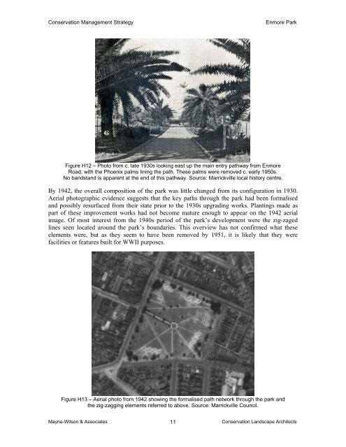
- Page 100 and 101: Conservation Management StrategyEnm
- Page 102 and 103: Conservation Management StrategyEnm
- Page 104 and 105: Conservation Management StrategyEnm
- Page 106 and 107: Conservation Management StrategyEnm
- Page 110 and 111: Conservation Management StrategyEnm
- Page 112 and 113: Conservation Management StrategyEnm
- Page 114 and 115: Conservation Management StrategyEnm
- Page 116 and 117: Conservation Management StrategyEnm
- Page 118 and 119: Conservation Management StrategyEnm
- Page 120 and 121: Conservation Management StrategyEnm
- Page 122 and 123: Conservation Management StrategyEnm
- Page 124 and 125: Conservation Management StrategyEnm
- Page 126 and 127: Conservation Management StrategyEnm
- Page 128 and 129: Conservation Management StrategyEnm
- Page 130 and 131: Conservation Management StrategyEnm
- Page 132 and 133: Conservation Management StrategyEnm
- Page 134 and 135: Conservation Management StrategyEnm
- Page 137 and 138: TREE MANAGEMENTCONSULTING ARBORICUL
- Page 139 and 140: URBAN FORESTRY AUSTRALIA - TREE MAN
- Page 141 and 142: URBAN FORESTRY AUSTRALIA - TREE MAN
- Page 143 and 144: URBAN FORESTRY AUSTRALIA - TREE MAN
- Page 145 and 146: URBAN FORESTRY AUSTRALIA - TREE MAN
- Page 147 and 148: URBAN FORESTRY AUSTRALIA - TREE MAN
- Page 149 and 150: URBAN FORESTRY AUSTRALIA - TREE MAN
- Page 151 and 152: URBAN FORESTRY AUSTRALIA - TREE MAN
- Page 153 and 154: URBAN FORESTRY AUSTRALIA - TREE MAN
- Page 155 and 156: URBAN FORESTRY AUSTRALIA - TREE MAN
- Page 157 and 158: URBAN FORESTRY AUSTRALIA - TREE MAN
- Page 159 and 160:
URBAN FORESTRY AUSTRALIA - TREE MAN
- Page 161 and 162:
URBAN FORESTRY AUSTRALIA - TREE MAN
- Page 163 and 164:
URBAN FORESTRY AUSTRALIA - TREE MAN
- Page 165 and 166:
URBAN FORESTRY AUSTRALIA - TREE MAN
- Page 167 and 168:
URBAN FORESTRY AUSTRALIA - TREE MAN
- Page 169 and 170:
URBAN FORESTRY AUSTRALIA - TREE MAN
- Page 171 and 172:
URBAN FORESTRY AUSTRALIA - TREE MAN
- Page 173 and 174:
URBAN FORESTRY AUSTRALIA - TREE MAN
- Page 175 and 176:
URBAN FORESTRY AUSTRALIA - TREE MAN
- Page 177 and 178:
URBAN FORESTRY AUSTRALIA - TREE MAN
- Page 179:
9.0 APPENDIXCArboricultural Audit a
- Page 182 and 183:
URBAN FORESTRY AUSTRALIA - TREE MAN
- Page 184 and 185:
URBAN FORESTRY AUSTRALIA - TREE MAN
- Page 186 and 187:
URBAN FORESTRY AUSTRALIA - TREE MAN
- Page 188 and 189:
URBAN FORESTRY AUSTRALIA - TREE MAN
- Page 190 and 191:
URBAN FORESTRY AUSTRALIA - TREE MAN
- Page 192 and 193:
URBAN FORESTRY AUSTRALIA - TREE MAN
- Page 194 and 195:
URBAN FORESTRY AUSTRALIA - TREE MAN
- Page 196 and 197:
URBAN FORESTRY AUSTRALIA - TREE MAN
- Page 198 and 199:
URBAN FORESTRY AUSTRALIA - TREE MAN
- Page 200 and 201:
URBAN FORESTRY AUSTRALIA - TREE MAN
- Page 202 and 203:
URBAN FORESTRY AUSTRALIA - TREE MAN
- Page 204 and 205:
URBAN FORESTRY AUSTRALIA - TREE MAN
- Page 206 and 207:
URBAN FORESTRY AUSTRALIA - TREE MAN
- Page 208 and 209:
URBAN FORESTRY AUSTRALIA - TREE MAN
- Page 210 and 211:
URBAN FORESTRY AUSTRALIA - TREE MAN
- Page 212 and 213:
URBAN FORESTRY AUSTRALIA - TREE MAN
- Page 214 and 215:
URBAN FORESTRY AUSTRALIA - TREE MAN
- Page 216 and 217:
URBAN FORESTRY AUSTRALIA - TREE MAN
- Page 218 and 219:
URBAN FORESTRY AUSTRALIA - TREE MAN
- Page 220 and 221:
URBAN FORESTRY AUSTRALIA - TREE MAN
- Page 222 and 223:
URBAN FORESTRY AUSTRALIA - TREE MAN
- Page 225 and 226:
Enmore Park Draft Plan of Managemen
- Page 227 and 228:
Enmore Park Draft Plan of Managemen
- Page 229:
9.0 APPENDIXELighting Appraisal103
- Page 232 and 233:
ut the security requirement may be
- Page 234 and 235:
High Mast FittingsThere are a numbe
- Page 236 and 237:
Appendix A is an excerpt from AS/NZ
- Page 238 and 239:
Power SuppliesOur recent experience
- Page 240 and 241:
Appendix BLighting, Art + ScienceEn
- Page 242:
9.0 APPENDIXFBibliographyBenson D.