Copyright 2008 Kendall/Hunt Publishing Company - CAMP
Copyright 2008 Kendall/Hunt Publishing Company - CAMP
Copyright 2008 Kendall/Hunt Publishing Company - CAMP

Create successful ePaper yourself
Turn your PDF publications into a flip-book with our unique Google optimized e-Paper software.
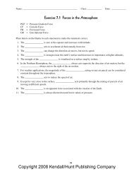
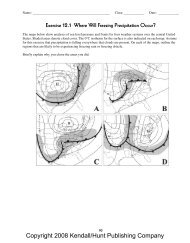
Name: _____________________________________________ Class: ____________ Date: ____________Exercise 24.1 Hurricane StructureThe top diagram below is a cross-section of the clouds and circulations within a strong hurricane. The shadedareas represent the eyewall and spiral rainbands. In the lower portions of the diagram, show schematically how thesurface pressure, surface wind speed, rainfall rate, 700 mb temperature and storm surge height vary across thestorm. Also, use the graph to the right of the cross-section to show how the wind speed varies with altitude in theeyewall. (Assume the hurricane is not stationary.)<strong>Copyright</strong> <strong>2008</strong> <strong>Kendall</strong>/<strong>Hunt</strong> <strong>Publishing</strong> <strong>Company</strong>179
<strong>Copyright</strong> <strong>2008</strong> <strong>Kendall</strong>/<strong>Hunt</strong> <strong>Publishing</strong> <strong>Company</strong>
Name: _____________________________________________ Class: ____________ Date: ____________Exercise 24.2 Hurricane TracksThe map below shows four hurricane tracks from recent years. The start of the track is indicated by a number.Determine if each track is typical or atypical for Atlantic Hurricanes.Circle OneHurricane #1 Typical AtypicalHurricane #2 Typical AtypicalHurricane #3 Typical AtypicalHurricane #4 Typical AtypicalOn the blank map below, draw in typical tracks that make landfall in each of the locations listed. Label each track.Hurricane #5 makes landfall in Louisiana.Hurricane #6 makes landfall on Long Island, New York and Connecticut.Hurricane #7 makes landfall on the Yucatan Peninsula, Mexico and again in Texas.<strong>Copyright</strong> <strong>2008</strong> <strong>Kendall</strong>/<strong>Hunt</strong> <strong>Publishing</strong> <strong>Company</strong>181
<strong>Copyright</strong> <strong>2008</strong> <strong>Kendall</strong>/<strong>Hunt</strong> <strong>Publishing</strong> <strong>Company</strong>
Name: _____________________________________________ Class: ____________ Date: ____________Exercise 24.3 Hurricane Winds and Saffir-Simpson RatingsInformation about the rotational wind speeds and forward movement of four hurricanes is provided in the sketchesbelow. Four quadrants in each storm are defined relative to the direction the storm is moving. Use the informationto evaluate the winds in the eyewall in the four quadrants of the storm (right, left, front and back). In addition, usethe information provided to determine the Saffir-Simpson rating of each hurricane.Wind in each quadrantSaffir-SimpsonratingHurricane Abby N: __________ S: __________ E: __________ W: __________ ______________Hurricane Benny NE: __________ SW: __________ NW: __________ SE: __________ ______________Hurricane Carolyn N: __________ S: __________ E: __________ W: __________ ______________Hurricane Don N: __________ S: __________ E: __________ W: __________ ______________<strong>Copyright</strong> <strong>2008</strong> <strong>Kendall</strong>/<strong>Hunt</strong> <strong>Publishing</strong> <strong>Company</strong>183
<strong>Copyright</strong> <strong>2008</strong> <strong>Kendall</strong>/<strong>Hunt</strong> <strong>Publishing</strong> <strong>Company</strong>
Name: _____________________________________________ Class: ____________ Date: ____________Exercise 24.4 Tropical Cyclones: Physical and Dynamical ProcessesCircle the word in parentheses that best captures the relationship. Then classify each as either:(T) triggers of tropical thunderstorms,(E) environmental requirements for tropical thunderstorms to organize into hurricanes, or(I) intensification mechanisms.1. _____ (Strong, Weak) vertical wind shear2. _____ Mid-latitude (cold, warm) fronts that reach the tropics3. _____ (Shallow, Deep) layer of warm water in the upper ocean4. _____ Winds that (increase rapidly, do not change) with height5. _____ Angular momentum (generation, dissipation, conservation)6. _____ (Increase, Decrease) of surface pressure in the storm’s center7. _____ Location (more than, less than) five degrees from the equator8. _____ Ocean surface temperatures (above, below) a threshold value9. _____ Low-level (divergence, convergence) in an easterly wave in the trade winds10. _____ Rising motion in the (Intertropical, Subtropical, Subpolar) Convergence Zone11. _____ Wind-induced transfer of heat from (atmosphere, ocean) to (atmosphere, ocean)12. _____ Rotation of winds such that distance from axis of rotation (increases, decreases)<strong>Copyright</strong> <strong>2008</strong> <strong>Kendall</strong>/<strong>Hunt</strong> <strong>Publishing</strong> <strong>Company</strong>185
<strong>Copyright</strong> <strong>2008</strong> <strong>Kendall</strong>/<strong>Hunt</strong> <strong>Publishing</strong> <strong>Company</strong>
Name: _____________________________________________ Class: ____________ Date: ____________Exercise 24.5 Potential Hurricane Impacts at LandfallThe map below shows the Gulf Coast of Florida and a hurricane approaching land. The arrow denotes the directionof hurricane motion. Assuming the hurricane follows this path:1. Which location(s) is(are) most vulnerable to storm surge? _________________________________________2. Which location(s) will experience the heaviest rainfall? ___________________________________________3. Which location(s) will experience the strongest winds? ___________________________________________4. Explain how the forward speed of a hurricane impacts the amount of freshwater flooding experienced bylocations inland, away from the coast.<strong>Copyright</strong> <strong>2008</strong> <strong>Kendall</strong>/<strong>Hunt</strong> <strong>Publishing</strong> <strong>Company</strong>187
<strong>Copyright</strong> <strong>2008</strong> <strong>Kendall</strong>/<strong>Hunt</strong> <strong>Publishing</strong> <strong>Company</strong>