Alafia River 03100204000004
Alafia River 03100204000004
Alafia River 03100204000004
- No tags were found...

You also want an ePaper? Increase the reach of your titles
YUMPU automatically turns print PDFs into web optimized ePapers that Google loves.
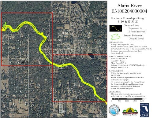
<strong>Alafia</strong> <strong>River</strong><strong>03100204000004</strong>Section - Township - Range9, 10 & 15-30-20Contour LinesExpressed in2-Foot IntervalsStream PerimeterGround LevelEXPLANATION:Survey Date: August 19, 2010Stream water level was 2.20 ft above sea level atUSGS 02301718 at time of the assessment NGVD 29.Contours are expressed in absolute depthbelow this level.Inset Map 1STREAM MORPHOLOGY:Perimeter 22,204.5 ft;Area 28.94 Acres;Mean Depth 9.57 ft;Volume 223.64 Acre-ft, (72,874,723 gallons);Deepest point 27.54 ftDATA SOURCES:2011 aerial photography provided by theSWFWMD.Stream perimeter digitized from SWFWMD2011 aerial photographs.All contours generated by the Florida Centerfor Community Design and Research fromsurvey data collected by USF Lake andStream Assessment Program.Inset Map 2DISCLAIMER:This map is for illustrative purposes only,and should not be used for stream navigation.Feet0 500 1,000 1,500 2,000
4161210141214181426121816122022141812Legend<strong>Alafia</strong> <strong>River</strong> Perimeter16142-Foot Contours´0 125 250 500 750 1,000Feet<strong>Alafia</strong> <strong>River</strong>Reach <strong>03100204000004</strong>Inset Map 11412
12101814<strong>Alafia</strong> <strong>River</strong>Reach <strong>03100204000004</strong>Inset Map 21412161820101616141418Legend<strong>Alafia</strong> <strong>River</strong> Perimeter2-Foot Contours1614´0 125 250 500 750 1,000Feet1612