Flight SWA 1455 Case Study Workbook - Center for Air ...
Flight SWA 1455 Case Study Workbook - Center for Air ...
Flight SWA 1455 Case Study Workbook - Center for Air ...
- No tags were found...

Create successful ePaper yourself
Turn your PDF publications into a flip-book with our unique Google optimized e-Paper software.
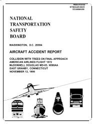
SYST 560/660OR 750Spring 2009<strong>Center</strong> <strong>for</strong> <strong>Air</strong> Transportation Systems ResearchSystem Engineering & Operations Research DepartmentSouthwest <strong>Air</strong>lines <strong>Flight</strong><strong>1455</strong> Accident Report<strong>Case</strong> <strong>Study</strong> <strong>Workbook</strong>INTSRUCTIONS:1. Read the NTSB accident report http://www.ntsb.gov/Publictn/2002/AAB0204.pdf2. Answer all questions in this workbookNote: Students are responsible <strong>for</strong> all the material in the workbook. Exam questionsare derived from the questions in the workbookCopyright Lance Sherry 20091
SUMMARYOn March 5, 2000, about 1811 Pacific standard time (PST),1 Southwest <strong>Air</strong>lines,Inc., flight <strong>1455</strong>, a Boeing 737-300 (737), N668SW, overran the departure end ofrunway 8 after landing at Burbank-Glendale-Pasadena <strong>Air</strong>port (BUR), Burbank,Cali<strong>for</strong>nia. The airplane touched down at approximately 182 knots, and about 20seconds later, at approximately 32 knots, collided with a metal blast fence and anairport perimeter wall. The airplane came to rest on a city street near a gasstation off of the airport property. Of the 142 persons on board, 2 passengerssustained serious injuries; 41 passengers and the captain sustained minorinjuries; and 94 passengers, 3 flight attendants, and the first officer sustained noinjuries.PROBABLE CAUSEThe National Transportation Safety Board determines that the probable cause ofthis accident was the flight crew’s excessive airspeed and flightpath angle duringthe approach and landing and its failure to abort the approach when stabilizedapproach criteria were not met. Contributing to the accident was the controller’spositioning of the airplane in such a manner as to leave no safe options <strong>for</strong> theflight crew other than a go-around maneuver.SIGNIFICANT EVENTS1. Changing surface wind conditions at the destination required the crew tochange their arrival plan2. <strong>Air</strong> Traffic Control caused the flight to be both fast and high whenbeginning the approach3. Captain attempted to descend to runway without using maximum ef<strong>for</strong>ts toslow4. Despite the excessive airspeed pilots continued with their plan to land(and NOT execute a go-around)5. captain delayed application of maximum breaking6. Shortest runway7. Runway closest to public area8. No EMAS systemCopyright Lance Sherry 20092
Reason’s Swiss Cheese Accident ModelWhat do the “Layers of Cheese” represent?What do the “holes” in layers of the cheese represent?When does an accident occur?Copyright Lance Sherry 20093
What is the difference between “latent” and “active” failures.Notes:“Swiss cheese” model <strong>for</strong>ces investigators to address latent failures within the causalsequence of events as well. As their name suggests, latent failures, unlike their activecounterparts, may lie dormant or undetected <strong>for</strong> hours, days, weeks, or even longer, untilone day they adversely affect the unsuspecting aircrew. Consequently, they may beoverlooked by investigators with even the best intentions.Unsafe Acts of Operators that ultimately led to the accident. More commonly referred toin aviation as aircrew/pilot error. Example, failing to properly scan the aircraft’sinstruments while in instrument meteorological conditions (IMC) or penetrating IMCwhen authorized only <strong>for</strong> visual meteorological conditions (VMC) may yield relativelyimmediate, and potentially grave, consequences.Preconditions <strong>for</strong> Unsafe Acts, this level involves conditions such as mental fatigue andpoor communication and coordination practices, often referred to as crew resourcemanagement (CRM). Not surprising, if fatigued aircrew fail to communicate andcoordinate their activities with others in the cockpit or individuals external to the aircraft(e.g., air traffic control, maintenance, etc.), poor decisions are made and errors oftenresult.Unsafe Supervision, the third level of human failure. If, <strong>for</strong> example, two inexperienced(and perhaps even below average pilots) are paired with each other and sent on a flightinto known adverse weather at night, is anyone really surprised by a tragic outcome? Tomake matters worse, if this questionable manning practice is coupled with the lack ofquality CRM training, the potential <strong>for</strong> miscommunication and ultimately, aircrew errors,Copyright Lance Sherry 20094
is magnified. In a sense then, the crew was “set up” <strong>for</strong> failure as crew coordination andultimately per<strong>for</strong>mance would be compromised. This is not to lessen the role played bythe aircrew, only that intervention and mitigation strategies might lie higher within thesystem.Organizational Infleunces can impact per<strong>for</strong>mance at all levels. For instance, in times offiscal austerity, funding is often cut, and as a result, training and flight time are curtailed.Consequently, supervisors are often left with no alternative but to task “non-proficient”aviators with complex tasks. Not surprisingly then, in the absence of good CRM training,communication and coordination failures will begin to appear as will a myriad of otherpreconditions, all of which will affect per<strong>for</strong>mance and elicit aircrew errors. There<strong>for</strong>e, itmakes sense that, if the accident rate is going to be reduced beyond current levels,investigators and analysts alike must examine the accident sequence in its entirety andexpand it beyond the cockpit. Ultimately, causal factors at all levels within theorganization must be addressed if any accident investigation and prevention system isgoing to succeed.Copyright Lance Sherry 20095
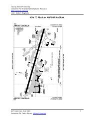
ChartsLayout Burbak <strong>Air</strong>port1. If an aircraft had to over-run a runway, which runway would be the worst runwayto overrun? Why?Copyright Lance Sherry 20096
Topographical Map of Surrounding Terrain Burbank <strong>Air</strong>port2. What is it about the geographical topography that makes arrivals from the west orsouth preferential?Copyright Lance Sherry 20097
<strong>Air</strong>port Diagramhttp://www.naco.faa.gov/d- tpp/0901/00067AD.PDFCopyright Lance Sherry 20098
Prevailing Wind Direction:STATION| JAN FEB MAR APR MAY JUN JUL AUG SEP OCT NOV DEC | ANNBURBANK AIRPORT, CA (KBUR). |ESE S S S S S S S S S S | S3. Given the prevailing wind direction(s), how would two runways be aligned toachieve complete coverage of the wind rose ?4. How many runways are there at BUR? List the runways and their MagneticHeadings?5. What is the difference between Magnetic Heading and True Heading?6. Locate the following on the airport diagram: (1) Control Tower, (2) MagneticVariation <strong>for</strong> airport, (3) Runway 8 [Tochdown Zone] Elevation, (4) Exactmagnetic heading of Runway 8, (5) EMAS <strong>for</strong> Runway 87. Runway 15 has a LAHSO? What does LAHSO stand <strong>for</strong>? When is it used? Whatproblem does it solve?Copyright Lance Sherry 20099
8. Runway 15 has a “AIRCRAFT HOLDING AREA AND BY-PASS APRON”What is this <strong>for</strong>? When is it used? What problem does it solve?9. At the bottom of the airport diagram is a Caution “BE ALERT TO RUNWAYCROSSING CLEARANCES. READBACK OF ALL RUNWAY HOLDINGINSTRUCTIONS IS REQUIRED” Describe a “runway holding instruction” andgive an example, Why is this required at this airport? What problem does thissolve?Copyright Lance Sherry 200910
Runway 8/26Dimensions: 5801 x 150 ft. / 1768 x 46 mSurface: asphalt/grooved, in excellent conditionWeight bearing capacity: Single wheel: 30.0Double wheel: 180.0Double tandem: 300.0Runway edge lights: high intensityOperational restrictions: OVERRUN 70 FT LONG BY 170 FT WIDE, ASPH,WEST END OF RY 08/26.RUNWAY 8 RUNWAY 26Latitude: 34-11.874435N34-11.858802NLongitude: 118-22.148322W118-20.997332WElevation: 727.2 ft.697.2 ft.Gradient: 0.5% 0.5%Traffic pattern: rightleftRunway heading: 076 magnetic, 091 trueMarkings: precision, in good conditionVisual slope indicator: 4-light PAPI on left (3.00degrees glide path)RVR equipment: touchdownApproach lights: MALSR: 1,400 foot mediumintensity approach lightingsystem with runway alignmentindicator lightsRunway end identifier lights: noTouchdown point: yes, no lightsInstrument approach: ILSObstructions: 14 ft. road, 300 ft. fromrunway, 7:1 slope to clear256 magnetic, 271 truenonprecision, in goodconditionyesyes, no lights40 ft. pole, 245 ft. fromrunway, 410 ft. right ofcenterline, 1:1 slope toclear+28' SIGN 90 FT FM RYTHLD, +14 FT BLASTFENCE AT THLDRunway 8, which is 6,032 feet long and 150 feet wide, is configured <strong>for</strong> precisioninstrument landings and equipped with high-intensity runway edge lights,distance-to-go markers, and a medium-intensity approach lighting system withrunway alignment indicator lights. A precision approach path indicator (PAPI) islocated 1,520 feet from the approach end of runway 8 on the left side of therunway.Copyright Lance Sherry 200911
1. Precision Instrument Approach2. High intensity runway edge lights3. Distance to go markers4. Medium Intensity Approach Lighting System5. Runway Alignment Indicator LightsCopyright Lance Sherry 200912
6. Precision Approach Path Indicator (PAPI)Copyright Lance Sherry 200913
7. Show the location of the PAPI (1,520 feet from the approach end of runway8 on the left side of the runway) on the airport diagramCopyright Lance Sherry 200914
Runway Safety AreasTitle 14 CFR 139.309 defines the requirements <strong>for</strong> the provision andmaintenance of runway safety areas (RSA). The design and constructionstandards of RSAs are in Advisory Circular (AC) 150/5300-13, .<strong>Air</strong>port Design,.dated September 29, 1989.REQUIREMENTS: The AC indicates that the longitudinal dimensions of an RSAshould extend <strong>for</strong> the full length of the runway and 1,000 feet beyond the physicalthreshold of each runway end. The AC further indicates that the lateraldimensions of an RSA should extend 250 feet both left and right of the runwaycenterline and <strong>for</strong> the full length of the longitudinal RSA.The lateral dimensions of the runway 8 RSA measure 250 feet on each side ofthe runway centerline, except <strong>for</strong> the southern edge of runway 8 east of therunway 15/33 intersection, which measures 125 feet and is marked with amovement/non-movement area delineator line.The passenger terminal is located south of runway 8 in this area. The longitudinaldimensions of the RSA at the arrival end of runway 8 measure 200 feet, and nosignificant longitudinal RSA exists on the departure end of runway 8. A metalblast fence is located 32 feet from the departure end of runway 8.On March 16, 2000, the Burbank-Glendale-Pasadena <strong>Air</strong>port Authority ExecutiveDirector sent a letter to the Safety Board.s <strong>Air</strong>port/Emergency Response GroupChairman to clarify the status of RSAs at BUR. In his letter, he stated thefollowing:The Authority determined that the greatest safety concern and risk to life andproperty was the close proximity of the passenger terminal and the closeproximity of parked and taxiing aircraft adjacent to both runways. The Authoritymade the decision to pursue replacement of the passenger terminal as itshighest priority..Concurrently with the process of replacing the terminal, theAuthority has pursued the acquisition of clear zone properties and hasconsidered the possibility of lowering Hollywood Way <strong>for</strong> the purpose of creatinga[n] overrun area. The Authority did successfully acquire some existing parkinglots in the RPZ (runway protection zone).On August 14, 2000, the airport authority submitted an application to the city ofBurbank to construct a replacement passenger terminal that would be located 1/2mile north of the current terminal. However, in an April 10, 2002, letter, theBurbank-Glendale-Pasadena <strong>Air</strong>port Authority Executive Director in<strong>for</strong>med theSafety Board that .58% of the voters of Burbank approved an initiative thatdeprives the Burbank City Council of its power to approve any terminal projectagreement with the <strong>Air</strong>port Authority unless and until a lengthy series ofconditions[22] is met.. As a result, on December 4, 2001, the City ofCopyright Lance Sherry 200915
Burbank .imposed a moratorium on the issuance of building permits <strong>for</strong> any andall activities at the airport that would require permits.[which] has effectively haltedall development activity at the airport..1. Draw the Required Safety Areas (RSA) <strong>for</strong> Runway 8 on the <strong>Air</strong>portDiagram2. Draw the Actual RSA <strong>for</strong> Runway 8 on the <strong>Air</strong>port Diagram3. Does the RSA <strong>for</strong> Runway 8 meet the requirements? Where is it short?4. Who should be liable <strong>for</strong> any shortcomings? Explain?recommended RSA may extend to 500 feet in width, and 1,000 feet beyond each runwayend (according to U.S. Federal Aviation Administration recommendations; 1000 feet isequivalent to the international ICAO-RESA of 240m plus 60m strip).5. Why do the regulations <strong>for</strong> RSA keep getting larger over time?Copyright Lance Sherry 200916
Copyright Lance Sherry 200917
Engineered Materials Arresting SystemOn August 17, 2001, the FAA.s <strong>Air</strong>port Improvement Program awarded $1.9million to BUR to install an engineered materials arresting system (EMAS) at thedeparture end of runway 8. The investigation revealed that installation of anEMAS was completed in January 2002 and that the system was fully operational.The system is about 170 feet long and 170 feet wide. No other EMASs areprojected to be installed at BUR.1. What is the purpose of the <strong>Air</strong>port Improvement Program (AIP)?2. What entity is responsible <strong>for</strong> administering the <strong>Air</strong>port Improvement Program?3. What are the advantages/disadvantages of government participation in airportdevelopment?Copyright Lance Sherry 200918
4. What is an EMAS and how does it work?Copyright Lance Sherry 200919
Copyright Lance Sherry 200920
Approach Charthttp://204.108.4.16/d-tpp/0901/00067ILZ8.PDFCopyright Lance Sherry 200921
Enroute Aeronautical Chart1. Locate the Palmdale VOR (PMD)2. Locate the Van Nuys VOR/DME (VNY)3. What in<strong>for</strong>mation is transmitted to the aircraft by a VOR?4. What in<strong>for</strong>mation is transmitted to the aircraft by a DME?5. What is “VOR radial”6. What is a “DME arc”7. What are “Victor <strong>Air</strong>ways” Give an example.8. What is a MEA? What is a MOCA?9. What are “Intersections”? How are intersections defined? Give an example.10. What is “Mode C”? Why is there a Mode C circle at 30nm radius from the LAXVOR/DME?Copyright Lance Sherry 200922
Las Vegas to Burbank RouteSouthwest <strong>Air</strong>lines records indicate that the accident airplane arrived at LAS fromLos Angeles International <strong>Air</strong>port, Los Angeles, Cali<strong>for</strong>nia, about 1630, almost 2hours behind schedule, because of rain and gusting winds in the LAS area. …<strong>Flight</strong> <strong>1455</strong> departed the gate about 1650, more than 2 hours behind schedule.[<strong>Air</strong>craft schedule <strong>Flight</strong> XXXX Depart LAX 13:20 and Arrive LAS 14:25<strong>Flight</strong> <strong>1455</strong> Depart LAS 14:45 Arrive BUR 15:45]1. Draw a space-time diagram <strong>for</strong> <strong>Flight</strong> <strong>1455</strong> (LAX-LAS-BUR). Show: ScheduledDeparture Times (SDT), Scheduled Arrival Times (SAT), Actual Arrival Times(AAT), Actual Departure Times (ADT), Scheduled Turn Around Time (STAT),Actual Turn Around Time (ATAT), Slack. (Assume Schedule Turn Around Time= 20 minutes)LAX __________________________________________________________________LAS __________________________________________________________________BUR __________________________________________________________________During post-accident interviews, the flight crew indicated to Safety Boardinvestigators that the takeoff and en route portions of the flight to BUR werenormal and uneventful. The first officer stated that after the flight crossed thePMD very high frequency omni-directional radio range (VOR)2 navigationtransmitter at 8,000 feet, he obtained in<strong>for</strong>mation Oscar from the BUR airportterminal in<strong>for</strong>mation service (ATIS),Copyright Lance Sherry 200923
2. What is the Great Circle Distance between LAS and BUR. Seehttp://gc.kls2.com/3. What is the definition of a Great Circle Distance4. Where is the PMD VOR. Locate on the Enroute Aeronautical Chart5. What altitude (feet) did the aircraft pass over PMDThe first officer stated that after the flight crossed the PMD very high frequencyomni-directional radio range (VOR) navigation transmitter at 8,000 feet, heobtained in<strong>for</strong>mation Oscar from the BUR airport terminal in<strong>for</strong>mation service(ATIS), which indicated that winds were from 260° at 18 knots, gusting to 26knots, and that aircraft were landing on runways 33 and 26. At 1754:21, thecaptain stated, .plan on [runway] three three at the moment. [A]pproach descentchecklist when you get the chance..6. When the aircraft passed over PMD, what was the direction and magnitude of thewind at BUR?Copyright Lance Sherry 200924
7. When the aircraft passed over PMD, what runway(s) was in use at BUR?8. What runway did the Captain show preference towards? Why? What were therisks of his choice of runway?At 1802:52, the flight crew was advised by the Southern Cali<strong>for</strong>nia terminal radarapproach control (SCT) Woodland controller that the current ATIS wasin<strong>for</strong>mation Papa and that they should expect an instrument landing system (ILS)landing on runway 8. At 1803:29, when the airplane was about 20 nautical miles(nm) north of the BUDDE outer marker3 at an altitude of about 8,000 feet meansea level (msl), the Woodland controller instructed flight <strong>1455</strong> to turn left to aheading of 190° and to descend to and maintain 6,000 feet msl. The first officeracknowledged the instructions.9. Locate the BUDDE outer-marker on the Runway 8 Approach Chart. How is thefix defined (i.e. what VOR rdial, what DME distance)?10. When the aircraft was approx 20 nm from BUDDE, what runway(s) was in use atBUR?Copyright Lance Sherry 200925
At 1804:02, when the airplane was about 19 nm north of the BUDDE outermarker at an altitude of about 7,800 feet msl, the SCT Woodland controllerstated, .Southwest fourteen fifty five, maintain two thirty or greater .til advisedplease.. The captain acknowledged the airspeed adjustment assignment.4 TheWoodland controller indicated in a postaccident interview that he imposed thespeed restriction as part of sequencing Southwest flight <strong>1455</strong> betweenSouthwest flight 1713 and Executive Jet flight 278.11. Explain “…imposed the speed restriction as part of sequencing Southwest flight<strong>1455</strong> between Southwest flight 1713 and Executive Jet flight 278” What is a“speed restriction”? What is “sequencing”? How did this speed achieve the ATCgoal?After the first officer obtained in<strong>for</strong>mation Papa, he switched back to theapproach control frequency. At 1804:42, he in<strong>for</strong>med the captain that the targetairspeed <strong>for</strong> the approach would be 138 knots and, at 1804:49, that windswere .down to six knots.. A few seconds later, he confirmed that aircraft werelanding at BUR on runway 8. At 1805:08, when the airplane was about 16 nmnorth of the BUDDE outer marker at an altitude of about 6,000 feet msl, the SCTWoodland controller instructed flight <strong>1455</strong> to .turn left heading one six zero.. At1805:13, the captain indicated to the first officer that ATC .wants two hundredthirty knots or greater, <strong>for</strong> a while..Copyright Lance Sherry 200926
1. What is the Approach Control Frequency <strong>for</strong> BUR? (See approach chart)2. What is the sequence of ATC controllers a flight will communicate withfrom Cruise to the GateCopyright Lance Sherry 200927
3. Why did the ATC want “two hundred thirty knots or greater, <strong>for</strong> a while..”At 1805:54, the SCT Woodland controller cleared flight <strong>1455</strong> to descend to andmaintain 5,000 feet and advised the pilots that they were following companytraffic (Southwest <strong>Air</strong>lines flight 1713) that was at their .one o.clock and twelvemiles [ahead of them] turning onto the final out of <strong>for</strong>ty six hundred.. The firstofficer acknowledged the clearance.At 1807:43, the Woodland controller cleared flight <strong>1455</strong> to descend to andmaintain 3,000 feet. The first officer acknowledged the clearance.At 1808:18, the first officer notified ATC that he had the Southwest traffic in sight.1. What is the pilot’s responsibility when they have the “traffic in sight”?Copyright Lance Sherry 200928
At 1808:19, the Woodland controller issued an altitude restriction bystating, .cross Van Nuys at or above three thousand,[5] cleared visual approachrunway eight..6 The first officer acknowledged the clearance. At 1808:36, as theairplane was descending through about 3,800 feet msl, the captain began turningto the left <strong>for</strong> the final approach.2. What altitude was the flight instructed to cross Nav Nuys VOR/DME?3. What is the significance of “cleared [<strong>for</strong>] visual approach”?4. Who is responsible <strong>for</strong> aircraft separation during a “visual approach”?5. Which method results in the highest throughput (i.e. flights/minute) “visualflight rules” or “instrument flight rules”? How is higher throughputachieved? What are the risks?Copyright Lance Sherry 200929
In post accident interviews, the flight crew told investigators that, during theapproach, the captain.s navigation radio was tuned to the ILS frequency <strong>for</strong>runway 8, and the first officer.s radio was tuned to the Van Nuys VOR. Theyindicated that the autopilot was engaged in the VOR/LOC mode7 and that theairplane captured the localizer course but then overshot the centerline be<strong>for</strong>ecorrecting back.8 The captain stated to investigators that as the flight passedabout 2 miles west of Van Nuys at 3,000 feet at approximately 220 to 230 knots,he deployed the speed brakes.1. When the Captain’s navigation radio was tuned to the ILS frequency <strong>for</strong>runway 8, what in<strong>for</strong>mation was being displayed in the cockpit from theILS?2. What trajectory did the aircraft follow when capturing the Localizer? Whatdoes it mean “airplane captured the localizer course but then overshot thecenterline be<strong>for</strong>e correcting back”. Draw this trajectory on the RwyApproach Chart.3. What altitude did the aircraft cross 2miles abeam of Van Nuys? Was thisthe correct altitude?4. Was the aircraft at the right altitude to cross BUDDE OM/INT (OuterMarker/Intersection)?Copyright Lance Sherry 200930
5. What are “speed brakes” (also known as “airbrakes”)? How do they work?Explain using equationMass dVelocity/dt = Thrust – Drag – (Weight (sin (<strong>Flight</strong> Path Angle)))What parameter is affected by Speedbrakes? For fixed Thrust setting andconstant <strong>Flight</strong> Path Angle, what parameter is affected by Speed Barkes.From page 18A comparison of the recorded radar data of the accident airplane to 70 otherairplanes that had landed at BUR on runway 8 between 1000 and 2200 on June13 and 14, 2000,33 showed that of the 16 airplanes vectored from the north sideof BUR to land on runway 8, 12 were vectored to intercept the final approachcourse between 9 and 15 nm west of the runway threshold. <strong>Flight</strong> <strong>1455</strong> wasgiven vectors that resulted in interception of the final approach course about 8nm west of the runway threshold. The comparison also showed that theglidepaths of most airplanes approaching runway 8 were between 3° and 4°. Theaccident airplane.s glidepath was 7°.6. For flights arriving from the North, at what distance from the threshold ofRwy 8 were they vectored to intercept the runway course?7. What distance from the threshold of Rwy 8 was <strong>Flight</strong> <strong>1455</strong> vectored tointercept the runway course?Copyright Lance Sherry 200931
8. Why is this a problem?The captain stated in a post-accident interview that he was aware that Southwest<strong>Air</strong>lines. standard procedure14 was <strong>for</strong> the captain and first officer to call .1,000[feet above ground level (agl)], airspeed, and sink rate. when descending through1,000 feet. However, no such callouts were recorded by the CVR. The captainalso stated in a post-accident interview that he visually perceived that theairplane was fast. as it crossed the approach end of runway 8. CVR and FDRdata indicate that the airplane touched down at 1810:58 with flaps extended to30° at about 182 knots; flaps then extended to 40° during the ground roll at about145 knots.9. What does it mean officer “to call .1,000 [feet above ground level (agl)],airspeed, and sink rate. when descending through 1,000 feet.”?10. Why is this callout important?Copyright Lance Sherry 200932
11. Why is it significant that the Captain “visually perceived that the airplanewas fast. as it crossed the approach end of runway 8.”?12. Should pilots rely on their perceptions or trust the instruments?13. What is significant about the statement “… flaps then extended to 40°during the ground roll at about 145 knots”14. Why did the flaps not extend earlier?Copyright Lance Sherry 200933
The captain stated to Safety Board investigators that after touchdown, the end ofthe runway appeared to be closer than it should have been and that he thoughtthey might hit the blast fence wall. The captain indicated that he braked .prettygood. while attempting to stop the airplane. FDR data indicate that the captainunlocked the thrust reversers 3.86 seconds after touchdown and that the thrustreversers deployed 4.91 seconds after touchdown. The first officer stated toinvestigators that the captain applied the wheel brakes be<strong>for</strong>e the airplane haddecelerated to 80 knots15 and that, as the airplane passed the Southwest <strong>Air</strong>linespassenger boarding gates,16 he joined the captain in braking the airplane andapplied the brakes as hard as he could. The captain indicated that as theairplane neared the end of the runway, he initiated a right turn using only thenosewheel steering tiller (not the rudder pedals).15. What mechanisms are used to brake an aircraft on the ground? Explainhow each mechanism causes the airplane to decelerate? Are there anyrestrictions on using each mechanism?16. What is a nosewheel steering tiller? When is it used? Who uses it?At 1811:20, the cockpit area microphone (CAM) recorded impact sounds. Theairplane departed the right side of the runway about 30° from the runway heading,Copyright Lance Sherry 200934
penetrated a metal blast fence and an airport perimeter wall, and came to a stopon a city street off of the airport property. An emergency evacuation ensued, andall crewmembers and passengers successfully exited the airplane.17. Why was the aircraft steered to “the right side of the runway about 30°from the runway heading.” ?Copyright Lance Sherry 200935
<strong>Air</strong>plane Per<strong>for</strong>manceThe Safety Board conducted an airplane per<strong>for</strong>mance study in conjunction withthis accident investigation.FDR and radar data indicate that the airplane began its final descent to BURabout 3 nm from the runway 8 threshold. Taking into account the airplanesaltitude of 3,000 feet msl at the beginning of the descent and the 725-foot mslelevation of the touchdown zone (TDZ) on runway 8, geometry calculationsindicate that the airplane would have had to have descended at an averageflightpath angle of about 7° to touch down in the runway 8 TDZ.Radar and FDR data show that the airplane descended at an average flightpathangle of about 7° until flare, at an average vertical speed of 2,200 feet per minute(fpm), and at indicated airspeeds of between 182 and 200 knots. The airplanebegan to flare about 170 feet agl and flared <strong>for</strong> about 9 seconds be<strong>for</strong>e touchingdown at 182 knots indicated airspeed on runway 8. Average ground speed duringthe flare was 195 knots, indicating that the airplane traveled about 3,000 feetduring the flare.1. What was the aircraft altitude, airspeed, and distance from the threshold ofRunway 8 when the aircraft began it’s final descent to Runway 82. What was the Touch Down Zone Elevation <strong>for</strong> Runway 83. <strong>Air</strong>craft <strong>Flight</strong> Path Angle:a. What flight path angle would the aircraft have to descend to make theRunway 8 TDZ? (show work)Copyright Lance Sherry 200936
. How much altitude (feet) higher was the aircraft than it should have been<strong>for</strong> a 3 degree glideslope (show work)4. Rate of Descenta. Assuming a groundspeed of 200 knots, what is the rate of descent (feet perminute) required <strong>for</strong> the aircraft to descend from altitude to the TDZE <strong>for</strong>Runway 8 (show work)b. Assuming a groundspeed of 200 knots, what is the rate of descent (feet perminute) required <strong>for</strong> the aircraft to descend from the altitude required <strong>for</strong> anormal three degree glideslope (see Q3-b) (show work)Copyright Lance Sherry 200937
5. Using the equations Mass dVelocity/dt = Thrust – Drag – (Weight (sin (<strong>Flight</strong>Path Angle))), explain how the pilot can decelerate the aircraft (dV/dt < 0) in thissituation?6.7. What is a flare maneuver? When is it per<strong>for</strong>med? What does a flare maneuver doto airplane Lift? Why is a flare useful <strong>for</strong> landing?At the request of the Safety Board.s <strong>Air</strong>plane Per<strong>for</strong>mance Group, Boeing ranstopping distance simulations <strong>for</strong> this accident wherein maximum, medium, andminimum 737 autobrake applications, as well as maximum manual brakeapplications, were simulated <strong>for</strong> wet runway conditions after the 182-knottouchdown. These data indicate that the accident airplane would have requiredabout 5,000 feet of runway length after touchdown to stop using maximumautobrakes and about 4,700 feet of runway length after touchdown to stop usingmaximum manual brakes. Boeing stopping distance calculations based on FDRacceleration data show that the accident airplane traveled about 4,150 feet fromtouchdown to impact with the blast fence, indicating that the airplane toucheddown about 2,150 feet beyond the runway 8 threshold in the TDZ8. What was the purpose of the Boeing study? What did it prove?Copyright Lance Sherry 200938
“Swiss Cheese” Model Analysis <strong>for</strong> <strong>Flight</strong> <strong>1455</strong>Describe the “holes” in each of these “layers”LayersPublished procedures (Approach Charts)HolesPublished ATC procedures <strong>for</strong> arrivalsfrom the NorthPublished Stablized Approach Proceduresand CheclistsCrew Resource Management TrainingPublished <strong>Air</strong>port Runway Safety AreaRequirements<strong>Air</strong>port Requirements <strong>for</strong> Installation ofEMASSATC Approach Clearance InstructionsPilots acceptance <strong>for</strong> “late” clearanceATC monitoring approachPilot rules <strong>for</strong> “stabilized approach”Pilot rules <strong>for</strong> Go AroundChecklist against “pressing”Autobrake LimitationsCopyright Lance Sherry 200939
EpilogueBurbank city officials demanded that Southwest <strong>Air</strong>lines pay their $40,000 bill <strong>for</strong>services, including overtime <strong>for</strong> police officers and firefighters, related to the March 5accident. Southwest refused to pay stating that they are entitled to emergency servicessince they pay taxes to the cityCopyright Lance Sherry 200940