Langcliffe - Yorkshire Dales National Park
Langcliffe - Yorkshire Dales National Park
Langcliffe - Yorkshire Dales National Park
- No tags were found...

Create successful ePaper yourself
Turn your PDF publications into a flip-book with our unique Google optimized e-Paper software.
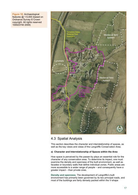
Figure 10: Archaeologicalfeatures @ 1:5,000 (based onOrdnance Survey © Crowncopyright. All rights reserved100023740 2009)<strong>Yorkshire</strong> <strong>Dales</strong><strong>National</strong> <strong>Park</strong>boundaryMedieval fieldsystemLynchetsMedieval fieldsystemConservationarea boundary(prior toreview)N4.3 Spatial AnalysisThis section describes the character and interrelationship of spaces, aswell as the key views and vistas of the <strong>Langcliffe</strong> Conservation Area.a) Character and Interrelationship of Spaces within the AreaHow space is perceived by the passer-by plays an essential role for thecharacter of any conservation area. To determine its impact, one mustexamine the density and openness of the built environment, as well asfacades or boundary walls that define individual zones. Public areas aremore accessible to a wider range of people – and consequently have agreater impact – than private ones.Density and openness. The development of <strong>Langcliffe</strong>’s builtenvironment has primarily been governed by its two principal roads, andmost of the buildings are fairly densely packed within the V-shape17