Langcliffe - Yorkshire Dales National Park
Langcliffe - Yorkshire Dales National Park
Langcliffe - Yorkshire Dales National Park
- No tags were found...

Create successful ePaper yourself
Turn your PDF publications into a flip-book with our unique Google optimized e-Paper software.
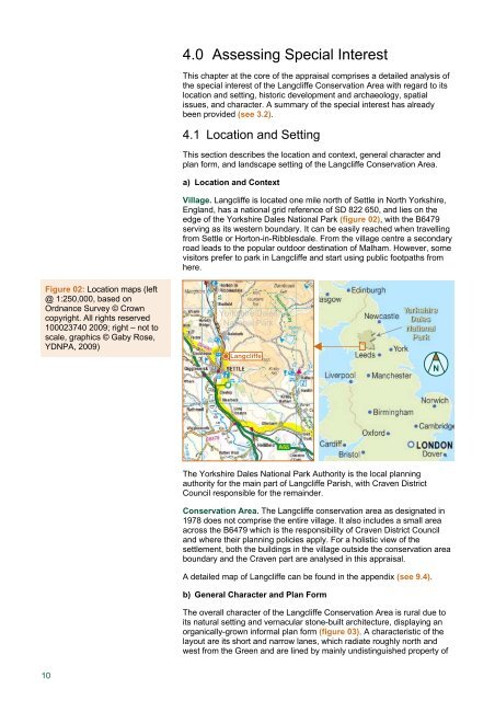
4.0 Assessing Special InterestThis chapter at the core of the appraisal comprises a detailed analysis ofthe special interest of the <strong>Langcliffe</strong> Conservation Area with regard to itslocation and setting, historic development and archaeology, spatialissues, and character. A summary of the special interest has alreadybeen provided (see 3.2).4.1 Location and SettingThis section describes the location and context, general character andplan form, and landscape setting of the <strong>Langcliffe</strong> Conservation Area.a) Location and ContextVillage. <strong>Langcliffe</strong> is located one mile north of Settle in North <strong>Yorkshire</strong>,England, has a national grid reference of SD 822 650, and lies on theedge of the <strong>Yorkshire</strong> <strong>Dales</strong> <strong>National</strong> <strong>Park</strong> (figure 02), with the B6479serving as its western boundary. It can be easily reached when travellingfrom Settle or Horton-in-Ribblesdale. From the village centre a secondaryroad leads to the popular outdoor destination of Malham. However, somevisitors prefer to park in <strong>Langcliffe</strong> and start using public footpaths fromhere.Figure 02: Location maps (left@ 1:250,000, based onOrdnance Survey © Crowncopyright. All rights reserved100023740 2009; right – not toscale, graphics © Gaby Rose,YDNPA, 2009)<strong>Yorkshire</strong> <strong>Dales</strong><strong>National</strong> <strong>Park</strong><strong>Langcliffe</strong>NThe <strong>Yorkshire</strong> <strong>Dales</strong> <strong>National</strong> <strong>Park</strong> Authority is the local planningauthority for the main part of <strong>Langcliffe</strong> Parish, with Craven DistrictCouncil responsible for the remainder.Conservation Area. The <strong>Langcliffe</strong> conservation area as designated in1978 does not comprise the entire village. It also includes a small areaacross the B6479 which is the responsibility of Craven District Counciland where their planning policies apply. For a holistic view of thesettlement, both the buildings in the village outside the conservation areaboundary and the Craven part are analysed in this appraisal.A detailed map of <strong>Langcliffe</strong> can be found in the appendix (see 9.4).b) General Character and Plan FormThe overall character of the <strong>Langcliffe</strong> Conservation Area is rural due toits natural setting and vernacular stone-built architecture, displaying anorganically-grown informal plan form (figure 03). A characteristic of thelayout are its short and narrow lanes, which radiate roughly north andwest from the Green and are lined by mainly undistinguished property of10