Water in the Snake River Plain
Water in the Snake River Plain
Water in the Snake River Plain
- No tags were found...

Create successful ePaper yourself
Turn your PDF publications into a flip-book with our unique Google optimized e-Paper software.
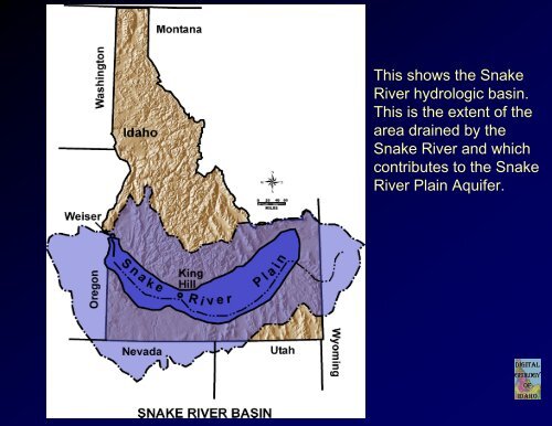
This shows <strong>the</strong> <strong>Snake</strong><strong>River</strong> hydrologic bas<strong>in</strong>.This is <strong>the</strong> extent of <strong>the</strong>area dra<strong>in</strong>ed by <strong>the</strong><strong>Snake</strong> <strong>River</strong> and whichcontributes to <strong>the</strong> <strong>Snake</strong><strong>River</strong> Pla<strong>in</strong> Aquifer.
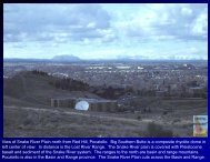
Red HillView of Pocatello <strong>in</strong> 1895 from <strong>the</strong> west. The Portneuf <strong>River</strong> meanders through. In <strong>the</strong> early 20 th century,houses and Raymond Park were built on <strong>the</strong> river flood pla<strong>in</strong>. This lead to repeated flood damage until <strong>the</strong>concrete channel was constructed by <strong>the</strong> U.S. Army Corps of Eng<strong>in</strong>eers <strong>in</strong> 1965.
Flood on <strong>the</strong> east side of <strong>the</strong> 100 block of South First Avenue <strong>in</strong> Pocatello, January 1911, causedby a rapid thaw and ra<strong>in</strong>storm. The flood waters came west from <strong>the</strong> hills at <strong>the</strong> head of CenterStreet.Bannock County Historical Society Collection.
Head gates com<strong>in</strong>g out of Niagara Spr<strong>in</strong>gs. Niagara Spr<strong>in</strong>gs is part of <strong>the</strong> ThousandSpr<strong>in</strong>gs complex system. This is <strong>the</strong> location of very productive fish farms.
View ofNiagaraSpr<strong>in</strong>gs.
View of <strong>the</strong> town of Good<strong>in</strong>g, <strong>in</strong> <strong>the</strong> Magic Valley. The slide shows <strong>the</strong>canal, typical orthogonal layout, and irrigated fields.
Milner Dam, just west of Burley, at high water.
View of water be<strong>in</strong>g passed through Milner Dam dur<strong>in</strong>g spr<strong>in</strong>gtime. Shows a notablyhigh flow.
Bechler <strong>River</strong> falls, <strong>in</strong> Yellowstone National Park.
Picture of Coats Dairy, <strong>in</strong> Dayton. Shows a Conf<strong>in</strong>ed Animal Feed<strong>in</strong>g Operation. Alsoshows wheel l<strong>in</strong>e for irrigated alfalfa.
Ore-Ida waste ponds from potato plant west of American Falls. Color <strong>in</strong>dicates differentk<strong>in</strong>ds of waste water. This water no doubt s<strong>in</strong>ks <strong>in</strong>to <strong>the</strong> subsurface. <strong>Snake</strong> <strong>River</strong> <strong>in</strong> upper part ofview. View is to <strong>the</strong> South.
Hagerman Fossil Beds National Monument. Fresh exposures are due to recentlandslides, caused by leakage from now-abandoned irrigation systems on <strong>the</strong> upland.
Dairy operation north of Buhl.
Milner Dam, view to west.
Irrigated fields north of Oakley, Albion Range <strong>in</strong> far right distance.
Old American Falls town site.
Conf<strong>in</strong>ed Animal Feed<strong>in</strong>g operation, American Falls Idaho.