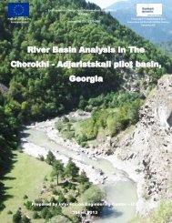
Nokia Standard Document Template - Environmental Protection of ...
Nokia Standard Document Template - Environmental Protection of ...
Nokia Standard Document Template - Environmental Protection of ...
- No tags were found...

You also want an ePaper? Increase the reach of your titles
YUMPU automatically turns print PDFs into web optimized ePapers that Google loves.
4th Mission Report _KE3_Jan –Feb 20133) It was recommended that the Department commits to establishing internal AQCs for at least the mainnutrient parameters. The KE3 could provide distance training and support prior to his next visit.4) For Hydrobiological Analysis, it was recommended that further support will be required from theProject to engage specialist NKEs to assist in identifying the species <strong>of</strong> the BMIs, and calculating the EQRs<strong>of</strong> the Water bodies. A request was also made to arrange a visit to a European Centre <strong>of</strong> Excellence forBMIs.Water Body Delineation (15th-16th February)A number <strong>of</strong> meetings were held between KE3, CWME Vahagn Tonoyan, KE4 & KE5 and Aram Gevorgyan,GIS Expert, to discuss the delineation <strong>of</strong> water bodies in the pilot areas <strong>of</strong> the Akuryan & MetsamorRivers.According to the ToR for the project the typology must apply the simple system A for the Water Body(WB) delineation <strong>of</strong> the WFD, which recommends applying the following descriptors:1) Altitude typologyhigh: >800 mmid-altitude: 200 to 800 mlowland: 800m), therefore this was <strong>of</strong> limited application.2) GeologycalcareoussiliceousorganicMost <strong>of</strong> pilot area is siliceous, therefore this was <strong>of</strong> limited application.3) Size typology based on catchment areasmall: 10 to 100 km2medium: >100 to 1 000 km2large: >1 000 to 10 000 km2very large: >10 000 km2Using this characterization 62 water bodies were identified, comprising 50 natural river water bodies &12 artificial water bodies.The KE3 reviewed the available physical/chemical data and the Armenian River Basin Analysis Report andwas able to identify at least five water bodies at risk from anthropogenic activities. This is summarised in adraft table in Appendix 9, which will be further developed when the relevant data has been retrieved.Armenia has recently introduced a national classification system with 5 categories for defining the states<strong>of</strong> their water bodies. This takes into account the normal natural background physical/ chemicalparameters characteristics <strong>of</strong> the Akuryan River and has been used to asses the river at differentmonitoring points (Appendix 10). Although this is different from the WFD classification system, this couldstill be a useful tool to undertake a preliminary classification as required in the baseline study.2. AZERBAIJAN (17TH - 23RD MARCH 2013)Baku Monitoring Centre <strong>of</strong> <strong>Environmental</strong> Pollution 17th to 21st FebruaryPage 7 <strong>of</strong> 36