SETTLEMENT CANYON RESERVOIR - Division of Water Quality
SETTLEMENT CANYON RESERVOIR - Division of Water Quality
SETTLEMENT CANYON RESERVOIR - Division of Water Quality

You also want an ePaper? Increase the reach of your titles
YUMPU automatically turns print PDFs into web optimized ePapers that Google loves.
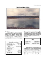
<strong>SETTLEMENT</strong> <strong>CANYON</strong> <strong>RESERVOIR</strong><strong>SETTLEMENT</strong> <strong>CANYON</strong> <strong>RESERVOIR</strong>IntroductionSettlement Canyon Reservoir is an small reservoir atthe base <strong>of</strong> the Oquirrh Mountains. It is at the foot <strong>of</strong>Settlement Canyon, a narrow, steep canyon immediatelysouth <strong>of</strong> Tooele. Settlement Canyon Reservoir wascreated in 1966 by the construction <strong>of</strong> an earth-fill dam.The reservoir shoreline is privately owned, but publicaccess is unrestricted. <strong>Water</strong> use <strong>of</strong> reservoir water isprimarily for irrigation in addition to the recreational values.LocationCountySanpeteLongitude / Latitude 112 17 33 / 40 30 37USGS Maps Sterling, UT 1966DeLorme's Utah Atlas & Gazetteer TM Page 37 A-6Cataloging Unit San Pitch (16030004)Characteristics and MorphometryLake elevation (meters / feet) 1,627 / 5,340Surface area (hectares / acres) 12.75 / 315<strong>Water</strong>shed area (hectares / acres) 3,626 / 8,960Volume (m 3 / acre-feet)capacity 1,440,989 / 1,168conservation pool 0Annual inflow (m 3 / acre-feet) 4,934,000 / 4,000Retention time (years) 0.3Drawdown (m 3 / acre-feet) 1,356,850 / 1,100Depth (meters / feet)maximum 20 / 65.6mean 7.6 / 25Length (meters / feet) 357 / 1,172Width (meters / feet) 191 / 625Shoreline (meters / feet) 1,261 / 4,140<strong>Water</strong> is released into canals for agricultural purposes,and into Tooele City's municipal irrigation system forpressurized use in residential areas. Some springs abovethe reservoir are piped and the water is bought by TooeleCity for culinary purposes. It is anticipated that unlesswater conservation measures are implemented, populationgrowth will force the city to purchase increasing quantities<strong>of</strong> water from the reservoir.
LAKE REPORTSFile Contains Data forPostScript Printers Only
<strong>SETTLEMENT</strong> <strong>CANYON</strong> <strong>RESERVOIR</strong>RecreationSettlement Canyon Reservoir is accessible from U-36just south <strong>of</strong> Tooele. From downtown, go south on MainStreet. At the south end <strong>of</strong> town the road meets theOquirrh Mountains and bends towards the west, theresidential area ends, and there is a white, windowlessMasonic Lodge on the left. Turn left at the lodge, and goup the canyon for about 1/2 mile to the reservoir. Thereservoir is close enough to the city that Howard Clegg,former president <strong>of</strong> the Settlement Canyon IrrigationCompany, said "any kid in town could go up there and fishif he had a little ambition"Fishing is the only recreational use permitted on thereservoir. The reservoir and surrounding area areprivately owned, and public use is a privilege. Rememberyou are a guest.The county constructed some toilet facilities near thereservoir, but they have been heavily vandalized. LegionPark Campground is located one mile up the canyon fromthe reservoir. There are no other private or publiccampgrounds in the area.<strong>Water</strong>shed DescriptionSettlement Canyon Reservoir an impoundment <strong>of</strong>Settlement Creek in the Oquirrh Mountains. The canyonis steep and narrow, resulting in a small, deep reservoir.The entire watershed is homogenous, consisting <strong>of</strong> deeplydissected mountains. Slopes are very steep (>40%)throughout the watershed. There is some evidence <strong>of</strong>glaciation at the head <strong>of</strong> Settlement Canyon.The watershed high point, a peak on the ridge at theheadwaters <strong>of</strong> Settlement Creek, is 3,162 m (10,373 ft)above sea level, thereby developing a complex slope <strong>of</strong>16.7% to the reservoir. The average stream gradientabove the reservoir is 9.7% (514 feet per mile). The inflowis Settlement Canyon Creek, which is fed by snowmeltfrom the high Oquirrh Mountains and several springsimmediately upstream from the reservoir (some <strong>of</strong> theseare piped). The outlet is Settlement Canyon Creek.The soil associations that compose the watershedare listed in Appendix III.The vegetation communities consist <strong>of</strong> sagebrushgrassand pinyon-juniper. Spruce-fir and alpine vegetationcommuties are probably found at higher elevations. Thewatershed receives 41 - 102 cm (16 - 40 inches) <strong>of</strong>precipitation annually. The frost-free season around thereservoir is 140 -160 days per year.According to the 1982 Clean Lakes Inventory, landuse is entirely native grazing <strong>of</strong> mostly cattle and possiblysheep with some recreational use.Limnological AssessmentThe water quality <strong>of</strong> Settlement Canyon Reservoir isvery good. It is considered to be hard with a hardnessLimnological DataData sampled from STORET site: 596020Surface Data 1981 1990 1992Trophic Status M O MChlorophyll TSI - 48.81 49.62Secchi Depth TSI 40.02 52.78 43.93Phosphorous TSI 43.2 17.35 50.26Average TSI 41.61 39.65 47.94Chlorophyll a (ug/L) - 6.4 6.9Transparency (m) 4.1 1.7 3.1Total Phosphorous (ug/L) 10 3 25pH 8.3 8.2 7.9Total Susp. Solids (mg/L)
LAKE REPORTSD o C pH DOCond0 17.1 7.7 8.7 5031 17.1 7.8 8.6 5032 17.1 7.8 8.6 5033 17.0 7.8 8.6 5034 17.0 7.8 8.4 5045 16.9 7.7 7.7 5066 16.9 7.6 7.6 5087 16.8 7.7 7.9 5118 16.7 7.7 8.4 5129 16.4 7.8 8.6 510TempDOInformationManagement AgenciesWasatch Front Regional Council 292-4469<strong>Division</strong> <strong>of</strong> Wildlife Resources 538-4700<strong>Division</strong> <strong>of</strong> <strong>Water</strong> <strong>Quality</strong> 538-6146RecreationGreat Salt Lake Country Travel Region (SLC) 896-9222Tooele Chamber <strong>of</strong> Commerce 882-0690Reservoir AdministratorsSettlement Canyon Irrigation Company 882-0257competition, so populations <strong>of</strong> native fishes may still bepresent in the lake. Current stocking reports indicate thatDWR stocks the lake in excess <strong>of</strong> 15,00 0 catchablerainbow trout annually.Phytoplankton in the euphotic zone include thefollowing taxa (in order <strong>of</strong> dominance)Species Cell Volume % Density(mm 3 /liter) By VolumeSphaerocystis schroeteri7.923 57.82Dinobryon divergens 4.208 30.71Ceratium hirundinella 0.936 6.83Gloeocystis sp. 0.334 2.43Pennate diatoms 0.189 1.38Oocystis sp. 0.044 0.32Ankistrodesmus falcatus0.035 0.25Centric diatoms 0.018 0.13Unknown sphericalgreen alga 0.017 0.12Total 13.700Shannon-Weaver [H'] 1.06Species Evenness 0.48Species Richness [d] 0.34The phytoplankton community is dominated by thepresence <strong>of</strong> green algae and flagellates indicative <strong>of</strong> fairlygood water quality.Pollution AssessmentNonpoint pollution sources include the following:sedimentation and nutrient loading from grazing; andwastes or litter from recreation.Point pollution sources include the following:Beneficial Use ClassificationThe state beneficial use classifications include:boating and similar recreation (excluding swimming) (2B),cold water game fish and organisms in their food chain(3A) and agricultural uses (4).