Storm Data and Unusual Weather Phenomena - CIG
Storm Data and Unusual Weather Phenomena - CIG
Storm Data and Unusual Weather Phenomena - CIG
- No tags were found...
Create successful ePaper yourself
Turn your PDF publications into a flip-book with our unique Google optimized e-Paper software.
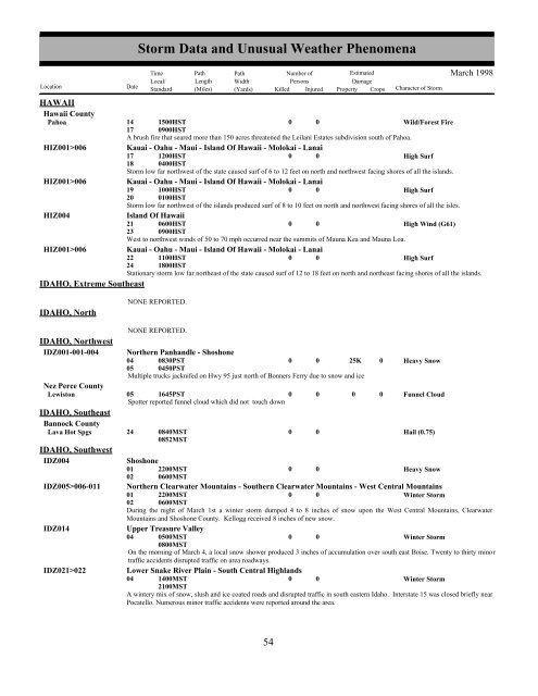
HAWAIIHawaii CountyPahoaHIZ001>006HIZ001>006HIZ004HIZ001>006IDAHO, Extreme Southeast<strong>Storm</strong> <strong>Data</strong> <strong>and</strong> <strong>Unusual</strong> <strong>Weather</strong> <strong>Phenomena</strong>TimePath PathNumber ofEstimatedLocal/ Length WidthPersonsDamageLocation DateSt<strong>and</strong>ard (Miles) (Yards) Killed Injured Property Crops Character of <strong>Storm</strong>March 199814171500HST0900HST0 0Wild/Forest FireA brush fire that seared more than 150 acres threatened the Leilani Estates subdivision south of Pahoa.Kauai - Oahu - Maui - Isl<strong>and</strong> Of Hawaii - Molokai - Lanai17 1200HST0 0High Surf18 0400HST<strong>Storm</strong> low far northwest of the state caused surf of 6 to 12 feet on north <strong>and</strong> northwest facing shores of all the isl<strong>and</strong>s.Kauai - Oahu - Maui - Isl<strong>and</strong> Of Hawaii - Molokai - Lanai19 1000HST0 0High Surf20 0100HST<strong>Storm</strong> low far northwest of the isl<strong>and</strong>s produced surf of 8 to 10 feet on north <strong>and</strong> northwest facing shores of all the isles.Isl<strong>and</strong> Of Hawaii21 0600HST0 0High Wind (G61)23 0900HSTWest to northwest winds of 50 to 70 mph occurred near the summits of Mauna Kea <strong>and</strong> Mauna Loa.Kauai - Oahu - Maui - Isl<strong>and</strong> Of Hawaii - Molokai - Lanai22 1100HST0 0High Surf24 1800HSTStationary storm low far northeast of the state caused surf of 12 to 18 feet on north <strong>and</strong> northeast facing shores of all the isl<strong>and</strong>s.IDAHO, NorthNONE REPORTED.IDAHO, NorthwestIDZ001-001-004NONE REPORTED.Northern Panh<strong>and</strong>le - Shoshone04050830PST0450PST0 0 25K 0Multiple trucks jacknifed on Hwy 95 just north of Bonners Ferry due to snow <strong>and</strong> iceNez Perce CountyLewiston 05 1645PST0 0 0 0Spotter reported funnel cloud which did not touch downIDAHO, SoutheastBannock CountyLava Hot SpgsIDAHO, SouthwestIDZ004IDZ005>006-011IDZ014IDZ021>022240840MST0852MST00Heavy SnowFunnel CloudHail (0.75)Shoshone01022200MST0600MST0 0Heavy SnowNorthern Clearwater Mountains - Southern Clearwater Mountains - West Central Mountains01 2200MST0 0Winter <strong>Storm</strong>02 0600MSTDuring the night of March 1st a winter storm dumped 4 to 8 inches of snow upon the West Central Mountains, ClearwaterMountains <strong>and</strong> Shoshone County. Kellogg received 8 inches of new snow.Upper Treasure Valley04 0500MST0800MST00Winter <strong>Storm</strong>On the morning of March 4, a local snow shower produced 3 inches of accumulation over south east Boise. Twenty to thirty mino rtraffic accidents disrupted traffic on area roadways.Lower Snake River Plain - South Central Highl<strong>and</strong>s04 1400MST2100MST0 0Winter <strong>Storm</strong>A wintery mix of snow, slush <strong>and</strong> ice coated roads <strong>and</strong> disrupted traffic in south eastern Idaho. Interstate 15 was closed briefly nearPocatello. Numerous minor traffic accidents were reported around the area.54 48


