Storm Data and Unusual Weather Phenomena - CIG
Storm Data and Unusual Weather Phenomena - CIG Storm Data and Unusual Weather Phenomena - CIG
WEST VIRGINIA, WestMcdowell CountyCountywideWVZ005>011-013>020-024>040-046>047WISCONSIN, Extreme SouthwestWISCONSIN, NortheastWIZ013-021>022-031-035>040-045-048>050WIZ013-021>022-038>040-048>050WIZ031-036>037-045WIZ005WIZ010>013-018>022-030>031-035>03620 2330EST0 0 15KFlash Flood21 0600ESTRains of 1.5 to 2 inches from 3 separate periods, fell on a saturated ground over a 24 hour period. The last shot of rain causedminor flooding on numerous small streams and creeks. Many secondary roads were closed. Some of the affected streams includedBig Sandy, Spring, and Reedy Creeks in Roane County, Armstrong and Paint Creeks in Fayette County, plus Blue and Kelly Creeksin Kanawha County. The headwaters of the Tug Fork River in McDowell County rose to 12 feet at Welch. Bankfull is 10 feet.No evacuations were needed.Wayne - Cabell - Mason - Jackson - Wood - Pleasants - Tyler - Lincoln - Putnam - Kanawha - Roane - Wirt -Calhoun - Ritchie - Doddridge - Mingo - Logan - Boone - Clay - Braxton - Gilmer - Lewis - Harrison - Taylor- Mcdowell - Wyoming - Raleigh - Fayette - Nicholas - Webster - Upshur - Barbour - Pocahontas - Randolph26 1200EST0 0Record Warmth31 2100ESTAn unusually prolong stretch of early spring heat lasted 6 consecutive days, The warmest readings occurred on the afternoon of the30th and 31st. Afternoon temperatures were in the 80s for the lowlands, with 70s across the mountainous counties. The growth ofthe new spring vegetation accelerated across the lowlands.NONE REPORTED.Waushara CountyPlainfield29 1005CSTPortage CountyBancroft29 1055CSTWaushara County10 W Wild Rose 29 1100CSTStorm Data and Unusual Weather PhenomenaTimePath PathNumber ofEstimatedLocal/ Length WidthPersonsDamageLocation DateStandard (Miles) (Yards) Killed Injured Property Crops Character of StormMarinette - Oconto - Door - Shawano - Wood - Portage - Waupaca - Outagamie - Brown - Kewaunee -Waushara - Winnebago - Calumet - Manitowoc08 0600CST0 0Winter Storm09 0600CSTA late winter storm brought heavy snowfall and strong winds to central and northeast Wisconsin March 8-9. The greatest amountsfell in central Wisconsin. Wautoma (Waushara co.) reported 11.0 inches. Winds gusting above 30 mph caused considerabledrifting. The strong winds blew ice and snow covered tree limbs onto power lines, resulting in power outages in several counties.Numerous traffic accidents were attributed to poor road conditions.Marinette - Oconto - Door - Outagamie - Brown - Kewaunee - Winnebago - Calumet - Manitowoc09 0600CST2200CST0 0 15KHigh WindShawano - Portage - Waupaca - Waushara09 0600CST0 0Strong Wind2200CSTStrong winds developed as a winter storm, which brought snow to northeast and central Wisconsin, moved away from the state.Official wind gusts reached 61 mph in Gills Rock (Door co.), 45 mph in Green Bay, 49 mph in Manitowoc (Manitowoc co.) and 46mph in Oshkosh (Winnebago co.). An unofficial gust of 55 mph was reported in Appleton (Outagamie co.). The strong windsknocked some power poles down and blew tree limbs onto power lines, causing power outages. The wind also whipped the newsnow around, producing low visibilities.Vilas13 0400CST0 0Heavy Snow2300CSTSnow fell across much of northern and central Wisconsin on March 13, but the heaviest totals fell in the far north-central part of thestate, where it was enhanced by Lake Superior. Presque Isle received 8.5 inches.Oneida - Forest - Florence - Marinette - Lincoln - Langlade - Menominee - Oconto - Door - Marathon -Shawano - Wood - Portage17192100CST0900CST0 0Winter StormYet another late winter storm affected central and northeast Wisconsin. A prolonged storm dropped a band of 6 to 10 inches of wetsnow, beginning on the 17th. Ten inches was recorded in Wausau (Marathon co.) and 9.0 inches in Wausaukee (Marinette co.).Over east-central Wisconsin, a mix of snow, sleet and freezing rain occurred.000000Hail (0.75)Hail (0.88)Hail (1.75)March 1998174 168
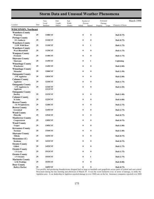
WISCONSIN, NortheastWaushara CountyWautoma29 1108CSTPortage County8 S Amherst 29 1110CSTWaushara County2 SW Wild Rose 29 1110CSTWaushara CountyWest Bloomfield 29 1129CSTWaupaca CountyFremont29 1140CSTShawano CountyShawano29 1149CSTWinnebago CountyWinchester29 1149CSTWinnebago CountyMenasha29 1200CSTOutagamie County3 W Appleton 29 1203CSTCalumet CountyAppleton29 1210CSTOutagamie County1 W Appleton to 29 1210CSTAppleton1212CSTOutagamie CountyDarboy29 1215CSTCalumet CountySt John29 1225CSTBrown County3 E Wrightstown 29 1240CSTBrown CountyGreenleaf29 1245CSTWood CountyPittsville29 1254CSTManitowoc CountyCooperstown29 1305CSTWood CountyVesper29 1305CSTKewaunee CountyNorman29 1310CSTShawano CountyTilleda29 1425CSTMenominee (C)Keshena29 1432CSTOconto CountyGillett29 1452CSTOconto County1 S Lena 29 1512CSTOconto County1 N Oconto 29 1515CSTMarinette County6 SE Peshtigo 29 1535CSTDoor CountyBaileys HarborStorm Data and Unusual Weather PhenomenaTimePath PathNumber ofEstimatedLocal/ Length WidthPersonsDamageLocation DateStandard (Miles) (Yards) Killed Injured Property Crops Character of Storm00000000000000000000000000010010000000000000000010Hail (0.75)Hail (0.75)Hail (1.75)Hail (1.75)Hail (1.75)LightningHail (2.00)Hail (1.50)Hail (2.00)Hail (1.75)Hail (2.50)Hail (1.00)Hail (4.00)Hail (2.75)Hail (2.75)Hail (0.75)Hail (0.75)Hail (1.00)Hail (1.00)Hail (0.75)Hail (0.75)Hail (1.75)Hail (1.75)Hail (2.75)Hail (0.88)March 199829 1605CST0 0Hail (0.75)Two prolific hail-producing thunderstorms dropped hail as large as baseballs and grapefruits across parts of central and east-centralWisconsin during the late morning and afternoon of March 29. It was the worst hailstorm ever, in terms of damage, to strike theAppleton area. A car dealership in Appleton reported damage to over 1000 cars on the lot. Insurance companies reported over 3000175 169
- Page 123 and 124: Storm Data and Unusual Weather Phen
- Page 125 and 126: NORTH CAROLINA, CentralDime size ha
- Page 127 and 128: NORTH CAROLINA, CentralGolfball siz
- Page 129 and 130: NORTH CAROLINA, Northwest and North
- Page 131 and 132: NORTH CAROLINA, SouthwestDeep low p
- Page 133 and 134: OHIO, NorthOHZ009>014-019>023-028>0
- Page 135 and 136: Storm Data and Unusual Weather Phen
- Page 137 and 138: OKLAHOMA, PanhandleOKZ002TexasOKZ00
- Page 139 and 140: OKLAHOMA, Western, Central and Sout
- Page 141 and 142: OKLAHOMA, Western, Central and Sout
- Page 143 and 144: PENNSYLVANIA, CentralAdams CountyCo
- Page 145 and 146: PENNSYLVANIA, Easta couple of inche
- Page 147 and 148: RHODE ISLANDKent CountyWest Warwick
- Page 149 and 150: SOUTH CAROLINA, North CoastalREPORT
- Page 151 and 152: SOUTH DAKOTA, WestSDZ001-012-012>01
- Page 153 and 154: TEXAS, CentralConcho CountyPaint Ro
- Page 155 and 156: TEXAS, NorthStorm Data and Unusual
- Page 157 and 158: TEXAS, NorthTarrant County1 W Crowl
- Page 159 and 160: TEXAS, NortheastHarrison County1 W
- Page 161 and 162: TEXAS, South CentralMedina CountySt
- Page 163 and 164: TEXAS, Western NorthWichita CountyW
- Page 165 and 166: Storm Data and Unusual Weather Phen
- Page 167 and 168: Storm Data and Unusual Weather Phen
- Page 169 and 170: VIRGINIA, NorthCulpeper CountyCount
- Page 171 and 172: VIRGINIA, SouthwestPittsylvania Cou
- Page 173: WEST VIRGINIA, EastA mudslide affec
- Page 177 and 178: Storm Data and Unusual Weather Phen
- Page 179 and 180: WISCONSIN, SouthwestLa Crosse Count
- Page 181 and 182: Storm Data and Unusual Weather Phen
- Page 186: To change your address, please retu
WISCONSIN, NortheastWaushara CountyWautoma29 1108CSTPortage County8 S Amherst 29 1110CSTWaushara County2 SW Wild Rose 29 1110CSTWaushara CountyWest Bloomfield 29 1129CSTWaupaca CountyFremont29 1140CSTShawano CountyShawano29 1149CSTWinnebago CountyWinchester29 1149CSTWinnebago CountyMenasha29 1200CSTOutagamie County3 W Appleton 29 1203CSTCalumet CountyAppleton29 1210CSTOutagamie County1 W Appleton to 29 1210CSTAppleton1212CSTOutagamie CountyDarboy29 1215CSTCalumet CountySt John29 1225CSTBrown County3 E Wrightstown 29 1240CSTBrown CountyGreenleaf29 1245CSTWood CountyPittsville29 1254CSTManitowoc CountyCooperstown29 1305CSTWood CountyVesper29 1305CSTKewaunee CountyNorman29 1310CSTShawano CountyTilleda29 1425CSTMenominee (C)Keshena29 1432CSTOconto CountyGillett29 1452CSTOconto County1 S Lena 29 1512CSTOconto County1 N Oconto 29 1515CSTMarinette County6 SE Peshtigo 29 1535CSTDoor CountyBaileys Harbor<strong>Storm</strong> <strong>Data</strong> <strong>and</strong> <strong>Unusual</strong> <strong>Weather</strong> <strong>Phenomena</strong>TimePath PathNumber ofEstimatedLocal/ Length WidthPersonsDamageLocation DateSt<strong>and</strong>ard (Miles) (Yards) Killed Injured Property Crops Character of <strong>Storm</strong>00000000000000000000000000010010000000000000000010Hail (0.75)Hail (0.75)Hail (1.75)Hail (1.75)Hail (1.75)LightningHail (2.00)Hail (1.50)Hail (2.00)Hail (1.75)Hail (2.50)Hail (1.00)Hail (4.00)Hail (2.75)Hail (2.75)Hail (0.75)Hail (0.75)Hail (1.00)Hail (1.00)Hail (0.75)Hail (0.75)Hail (1.75)Hail (1.75)Hail (2.75)Hail (0.88)March 199829 1605CST0 0Hail (0.75)Two prolific hail-producing thunderstorms dropped hail as large as baseballs <strong>and</strong> grapefruits across parts of central <strong>and</strong> east-centralWisconsin during the late morning <strong>and</strong> afternoon of March 29. It was the worst hailstorm ever, in terms of damage, to strike theAppleton area. A car dealership in Appleton reported damage to over 1000 cars on the lot. Insurance companies reported over 3000175 169


