Storm Data and Unusual Weather Phenomena - CIG
Storm Data and Unusual Weather Phenomena - CIG
Storm Data and Unusual Weather Phenomena - CIG
- No tags were found...
Create successful ePaper yourself
Turn your PDF publications into a flip-book with our unique Google optimized e-Paper software.
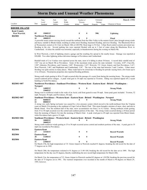
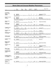
RHODE ISLANDKent CountyWest WarwickRIZ001<strong>Storm</strong> <strong>Data</strong> <strong>and</strong> <strong>Unusual</strong> <strong>Weather</strong> <strong>Phenomena</strong>TimePath PathNumber ofEstimatedLocal/ Length WidthPersonsDamageLocation DateSt<strong>and</strong>ard (Miles) (Yards) Killed Injured Property Crops Character of <strong>Storm</strong>March 199809 1900EST0 0 50KLightningNorthwest Providence10 1800EST0 0FloodA powerful storm system moving slowly toward the northeast from the Ohio Valley to the eastern Great Lakes brought strong winds<strong>and</strong> heavy rainfall to Rhode Isl<strong>and</strong>, resulting in urban street flooding, basement flooding, <strong>and</strong> river flooding. The Blackstone Riverat Woonsocket crested at 10.3 feet on March 10th at 6:00 PM; flood stage is 9.0 feet. Urban flood control systems prevented anyflooding in the city. Several parking lots were reported flooded with up to 3 feet of water along the Blackstone River inCumberl<strong>and</strong>. At times the rainfall was torrential, especially in thunderstorms during the evening on March 9th.In West Warwick, a bolt of lightning struck a garage <strong>and</strong> the resulting fire spread to the nearby house. Damage was reported at$50,000. Two other lightning strikes did minor damage in Providence <strong>and</strong> Cumberl<strong>and</strong>.Rainfall totals of 2 to 4 inches were reported across the state, most of it falling in about 30 hours. A record daily rainfall total of3.02" was set on March 9th at Providence. Some of the maximum totals across the state included: Coventry, 4.05"; Clayville,3.90"; Johnston, Providence, <strong>and</strong> Cranston, 3.60"; Woonsocket, 3.43"; Warwick, T.F. Green Airport, <strong>and</strong> East Providence, 3.41";West Warwick, 3.40"; <strong>and</strong> Hopkinton <strong>and</strong> Cumberl<strong>and</strong>, 3.30". The rest of the state had between 2 <strong>and</strong> 3 inches. Urban streetflooding was quite serious in many places. Many roads had to be closed due to flooding for periods varying from a few hours up to12 to 24 hours. Flood-prone properties also reported flooding problems.Strong south winds gusting to 40 to 55 mph occurred after the passage of a warm front during the morning hours. The strong windscaused scattered power outages. A peak wind gust to 54 mph was reported at Tiverton. Siding was reported ripped off a vacantbuilding in North Providence.RIZ001>007 Northwest Providence - Southeast Providence - Western Kent - Eastern Kent - Bristol - Washington -Newport12 1400EST1500EST0 0Strong WindsStrong west to northwest winds in the wake of an Arctic cold front gusted to near 50 mph. Some peak gusts included: Tiverton, 52mph; Newport, 50 mph; <strong>and</strong> Providence, 48 mph.RIZ002>007Southeast Providence - Western Kent - Eastern Kent - Bristol - Washington - Newport21220600EST0800EST0 0Strong WindsA strong very early Spring nor'easter was caused by a low pressure system which moved to the north-northeast from the Virginiacoast on March 21st passing to the southeast of Cape Cod on March 22nd. This storm brought a mixture of snow, sleet, <strong>and</strong> rain toRhode Isl<strong>and</strong>. Over the northern half of the state, snow accumulation was from 2 to 4.5 inches. Strong northeast winds gustingfrom 35 to 50 mph occurred over the central <strong>and</strong> southern portion of the state. The strong winds occurred during a 24-hour periodfrom the morning of March 21st into the morning of March 22nd. A peak wind gust to 49 mph was reported from Block Isl<strong>and</strong>,while Providence had a gust to 35 mph.RIZ002>006Southeast Providence - Western Kent - Eastern Kent - Bristol - Washington26 1000EST1800EST0 0Strong WindsStrong south-southwest winds gusting to 35 to 50 mph occurred across central <strong>and</strong> southern portions of the state. A peak gust to 35mph was recorded at Providence.RIZ004Eastern Kent27 1434EST0 0Record WarmthRIZ004Eastern Kent28 1140EST0 0Record WarmthRIZ004Eastern Kent31 1350EST0 0Record WarmthOn March 27th, the high temperature at T.F. Green Airport in Warwick reached 81 degrees, breaking the old record for the date of77 degrees set in 1945.On March 28th, the temperature rocketed to 81 degrees at 11:40 AM, breaking the old record for the date set in 1989. The hightemperature for the day was 83 degrees, thereby establishing the new record high temperature for March 28th.On March 31st, the temperature at T.F. Green Airport in Warwick reached 85 degrees at 1:50 PM, breaking the previous record forthe date of 75 degrees set in 1981. The warmest temperature ever recorded in the month of March is 90 degrees on March 29,1945, however.147 141


