Storm Data and Unusual Weather Phenomena - CIG
Storm Data and Unusual Weather Phenomena - CIG
Storm Data and Unusual Weather Phenomena - CIG
- No tags were found...
You also want an ePaper? Increase the reach of your titles
YUMPU automatically turns print PDFs into web optimized ePapers that Google loves.
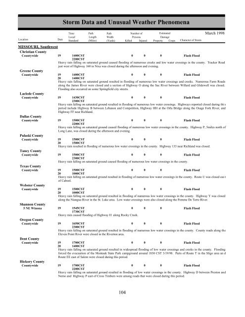
MISSOURI, SouthwestChristian CountyCountywideGreene CountyCountywideLaclede CountyCountywideDallas CountyCountywidePulaski CountyCountywideTaney CountyCountywideTexas CountyCountywideWebster CountyCountywide191400CST2200CST000Flash FloodHeavy rain falling on saturated ground caused flooding of numerous creeks <strong>and</strong> low water crossings in the county. Tracker Roadjust west of Highway 160 in Nixa was closed during the afternoon <strong>and</strong> evening.19201400CST1400CST0 0 0Flash FloodHeavy rain falling on saturated ground resulted in flooding of numerous low water crossings <strong>and</strong> creeks. Numerous Farm Roadsalong the James River were closed <strong>and</strong> a section of Highway O along the Sac River between Willard <strong>and</strong> Glidewell was closed.Flooding also occurred on some Springfield city streets.19 1430CST0 0 0Flash Flood2300CSTHeavy rain falling on saturated ground resulted in flooding of numerous low water crossings. Highways reported closed during thi speriod include Highway B between Lebanon <strong>and</strong> Competition, Highway HH at the Orla Bridge along the Osage Fork River, <strong>and</strong>Highway FF near Richl<strong>and</strong>.19 1500CST0 0 0Flash Flood2200CSTHeavy rain falling on saturated ground caused flooding of numerous low water crossings in the county. Highway P, 5miles north ofLong Lane, was closed during the afternoon <strong>and</strong> evening.19201500CST1500CST0 0 0Flash FloodHeavy rain resulted in flooding of numerous low water crossings in the county. Highway 133 near Richl<strong>and</strong> was closed.19 1500CST0 0 0Flash Flood2300CSTHeavy rain falling on saturated ground caused flooding of numerous low water crossings in the county.19201500CST1000CST0 0 0Flash FloodHeavy rain falling on saturated ground resulted in flooding of numerous low water crossings in the county. Route U was closed eas tof Cabool.19201500CST1000CST0 0 0Flash FloodHeavy rain falling on saturated ground resulted in flooding of numerous low water crossings in the county. Highway Y was closedalong the Niangua River in the St. Luke area. Low water crossings were also closed along the Pomme De Terre River.Shannon County5 NE Winona 19 1545CST1730CST0 0 0Flash FloodHeavy rain caused flooding of Highway H along Rocky Creek.Oregon CountyCountywide19 1650CST2300CST0 0 0Flash FloodHeavy rain falling on saturated ground resulted in flooding of numerous low water crossings in the county. County roads along theEleven Point River were closed in the Riverton area.Dent CountyCountywideHickory CountyCountywide<strong>Storm</strong> <strong>Data</strong> <strong>and</strong> <strong>Unusual</strong> <strong>Weather</strong> <strong>Phenomena</strong>TimePath PathNumber ofEstimatedLocal/ Length WidthPersonsDamageLocation DateSt<strong>and</strong>ard (Miles) (Yards) Killed Injured Property Crops Character of <strong>Storm</strong>March 199819201700CST1400CST0 0 0Flash FloodHeavy rain falling on saturated ground resulted in widespread flooding of low water crossings <strong>and</strong> creeks in the county. Floodingforced the evacuation of the Montauk State Park campground around 1830 CST 3/19/98. Parts of Route T in the Sligo area an dRoute EE east of Salem were closed during this period.19 1700CST0 0 0Flash Flood2200CSTHeavy rain falling on saturated ground resulted in flooding of low water crossings in the county. Highway D between Preston <strong>and</strong>Nemo <strong>and</strong> Highway P east of Cross Timbers were among roads that were closed during this period.104 98


