

Storm Data and Unusual Weather Phenomena - CIG
Storm Data and Unusual Weather Phenomena - CIG
Storm Data and Unusual Weather Phenomena - CIG
- No tags were found...

You also want an ePaper? Increase the reach of your titles
YUMPU automatically turns print PDFs into web optimized ePapers that Google loves.
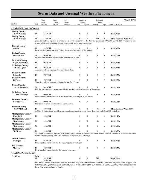
ALABAMA, North CentralShelby County6 NW Chelsea 19 2337CST0 0 0 0Shelby County6 NW Chelsea 19 2345CST0 0 380K 0Hail (0.75)Thunderstorm Wind (G65)Dime size hail was reported in Inverness. A downburst destroyed the Racetrac gas station at US 280 <strong>and</strong> AL 119. There were alsoseveral windows blown out <strong>and</strong> some construction trucks were overturned.Etowah CountyGallant 19 2357CST0 0 0 0 Hail (0.75)Dime size hail was reported in Gallant, in the southwest part of the county.Dallas CountyPleasant Hill 20 0010CST0 0 0 0 Hail (1.75)Golf ball size hail was reported from Pleasant Hill to Polk.St. Clair CountyLogan Martin Res 20 0013CST0 0 0 0 Hail (0.75)Talladega County7.5 NW Alpine 20 0014CST0 0 0 0 Hail (0.75)Dime size hail was reported at Logan Martin Dam.Dekalb CountyRainsville 20 0020CST0 0 0 0 Hail (0.75)Dekalb CountyFt Payne 20 0027CST0 0 0 0 Hail (0.75)Dime size hail was reported in Rainsville <strong>and</strong> Fort Payne.Coosa County10 NW Rockford 20 0025CST0 0 0 0 Hail (1.00)Hail the size of quarters was reported in Weogufka in the northern part of the county.Talladega County11 SW Sylacauga 20 0040CST0 0 0 0 Hail (0.75)Dime size hail was reported in Winterboro in the western part of the county.Lowndes CountyLowndesboro 20 0050CST0 0 0 0 Hail (1.25)Half dollar size hail was reported in Lowndesboro.Elmore County3 SW Millbrook 20 0100CST0 0 5K 0 Thunderstorm Wind (G55)A 30 to 40 foot antenna was blown down <strong>and</strong> numerous trees were blown down in a path about 150 yards long.Montgomery CountyHope Hull 20 0105CST0 0 0 0 Hail (1.25)Montgomery CountyMontgomery 20 0125CST0 0 4K 0 Hail (1.75)Montgomery CountyMontgomery 20 0128CST0 0 0 0 Hail (0.88)Montgomery CountyMt Meigs 20 0143CST0 0 0 0 Hail (0.75)Half dollar size hail was reported in Hope Hull, golf ball size hail was reported near Dannelley Field, nickel size hail was reported indowntown Montgomery, <strong>and</strong> dime size hail was reported near Mt Meigs.Macon CountyTuskegee 20 0215CST0 0 0 0 Hail (0.75)Dime size hail was reported in the western parts of Tuskegee.Lee CountyMarvyn 20 0259CST0 0 0 0 Hail (0.75)Dime size hail was reported in the Marvin community.ALABAMA, SoutheastALZ066<strong>Storm</strong> <strong>Data</strong> <strong>and</strong> <strong>Unusual</strong> <strong>Weather</strong> <strong>Phenomena</strong>TimePath PathNumber ofEstimatedLocal/ Length WidthPersonsDamageLocation DateSt<strong>and</strong>ard (Miles) (Yards) Killed Injured Property Crops Character of <strong>Storm</strong>Dale05 1615EST1630EST0070KHigh WindMarch 1998One half of tin roof blown off a furniture manufacturing plant one mile north of Ozark. Numerous large tree limbs snapped nearIndustrial Park. Quarter sized hail <strong>and</strong> wind gusts to 47 mph observed by EOC officials in Ozark. Lightning struck <strong>and</strong> destroyed ahome four miles northeast of Ozark.10 4


