Geology 103 Air Masses, Winds, Fronts Activity Answer Key ...
Geology 103 Air Masses, Winds, Fronts Activity Answer Key ...
Geology 103 Air Masses, Winds, Fronts Activity Answer Key ...
- No tags were found...

Create successful ePaper yourself
Turn your PDF publications into a flip-book with our unique Google optimized e-Paper software.
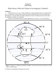
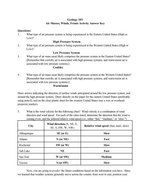
<strong>Geology</strong> <strong>103</strong><strong>Air</strong> <strong>Masses</strong>, <strong>Winds</strong>, <strong>Fronts</strong> <strong>Activity</strong> <strong>Answer</strong> <strong>Key</strong>Questions:1. What type of air pressure system is being experienced in the Eastern United States (High orLow)?High Pressure System2. What type of air pressure system is being experienced in the Western United States (High orLow)?Low Pressure System3. What type of air mass most likely comprises the pressure system in the Eastern United States?[Remember that cool/dry air is associated with high pressure systems, and warm/moist air isassociated with low pressure systems.]Cool/dry4. What type of air mass most likely comprises the pressure system in the Western United States?[Remember that cool/dry air is associated with high pressure systems, and warm/moist air isassociated with low pressure systems.]Warm/moistDraw arrows indicating the direction of surface winds anticipated around the low pressure system, andaround the high pressure system. Draw directly on the paper for the eastern United States (preferablyusing pencil), and on the clear plastic sheet for the western United States (use a wax or overheadprojector marker).5. What is the wind velocity for the following cities? Wind velocity is a combination of winddirection and wind speed. For each of the cities listed, determine the direction that the wind iscoming from, and the inferred relative wind speed (i.e., either “fast,” “medium,” or “slow.”)CityWind direction (N, NE, E,SE, S, SW, W, NW)Relative wind speed (fast, med., slow)Albuquerque SE (or E) SlowAtlanta N (or NE) FastRochester SW (or W) SlowSalt Lake NE FastSan José W (or SW) MediumTucson S (or SW) SlowNow, you are going to predict the future conditions based on the information you have. Sincewe learned that weather systems generally move across the country from west to east, position your
clear plastic sheet so that the weather system that was positioned over the western United States(whose center was near the base of the large arrow) is centered near the tip of the arrow drawn onyour map. Let’s assume that the eastern weather system is stalled (in other words, is not moving, forsome reason). These are conditions that happen with frequency.6. What type of front would you expect to form between the two air masses? Why?A warm front, because the air mass in the west is likely composed of warmerair (it has lower pressure), and the air mass in the east is likely composed of cooler air (ir hashigher pressure).7. What type of clouds/precipitation would your predict for the cities of Chicago and St. Louis (asthe Western air mass collides with the Eastern air mass)?A long period of light rain or drizzle, coming from flat clouds.