numero30_7:Maquetaci\363n AET.qxd - Universidad Politécnica de ...
numero30_7:Maquetaci\363n AET.qxd - Universidad Politécnica de ...
numero30_7:Maquetaci\363n AET.qxd - Universidad Politécnica de ...
- No tags were found...

You also want an ePaper? Increase the reach of your titles
YUMPU automatically turns print PDFs into web optimized ePapers that Google loves.
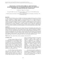
F. González,S. Kaiser, S. Merino, M. Huesca, A. Roldán, J.M. Cuevas y G. VenturaINTRODUCTIONIn times when many countries are concerned aboutthe reduction of CO 2 and other greenhouse gases tosatisfy the requirements of the Kyoto protocol, theavailability of updated cartography at different scalesbecomes more and more important. Internationalorganizations such as the European Space Agency(ESA) are involved in global projects that aim toprovi<strong>de</strong> these products to <strong>de</strong>cision and policymakersall over the world. One of the most <strong>de</strong>termining projectsis the currently running European GLOBCO-VER project (DUP-ESA, 2006). The objective is to<strong>de</strong>velop a service which will produce a 300m globalland cover map for the year 2005 using mainly fullresolution data acquired by the MERIS (MediumResolution Imaging Spectometer) sensor on-boardENVISAT (Joint Research Centre – Terrestrial EcosystemMonitoring, 2006).As the medium spatial resolution of MERIS-FR(Full Resolution) products may restrict the processof obtaining high-quality end-products in somecases, other satellite-<strong>de</strong>rived data with increased spatialresolution, such as the ones acquired by the AdvancedWi<strong>de</strong> Field Sensor (AWiFS) of the IndianRESOURCESAT-1 (National Remote SensingAgency, 2006) should be tested for their aptitu<strong>de</strong> toproduce high-quality land use - land cover (LULC)maps with a reasonable effort in terms of time andmoney. Benefits and disadvantages of using satelliteswith either increased spatial or spectral resolutionhave to be evaluated in the future to refine methodologiesfor LULC mapping.As a first step in this direction, the classification<strong>de</strong>scribed in this paper aims to supply informationabout pros and contras of using satellite data withdifferent spatial and spectral resolution for the creationof forest or LULC maps at any scale for researchersand <strong>de</strong>cision makers <strong>de</strong>aling with this issue.For that purpose, a classification based on an AWIFSimage of the Spanish province of Madrid was performedand the results were compared with previousclassification results for MERIS-FR data.STUDY AREAThe Spanish province of Madrid (figure 1) comprises8022 km² including the metropolitan area ofMadrid in the centre surroun<strong>de</strong>d by evergreen broadleavedforests (Quercus ilex) and shrublands, cultivatedand sparsely vegetated areas in the South-Eastand the Sierra <strong>de</strong> Guadarrama with its evergreen and<strong>de</strong>ciduous forests (Pinus sylvestris, Quercus pyrenaicaetc.) in the North-West.Figure 1. The province of Madrid (grey) situated in the centre of Spain86Revista <strong>de</strong> Tele<strong>de</strong>tección. ISSN: 1988-8740. 2008. 30: 85-91