numero30_7:Maquetaci\363n AET.qxd - Universidad Politécnica de ...
numero30_7:Maquetaci\363n AET.qxd - Universidad Politécnica de ...
numero30_7:Maquetaci\363n AET.qxd - Universidad Politécnica de ...
- No tags were found...

You also want an ePaper? Increase the reach of your titles
YUMPU automatically turns print PDFs into web optimized ePapers that Google loves.
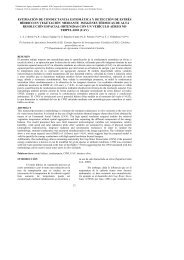
F. González,S. Kaiser, S. Merino, M. Huesca, A. Roldán, J.M. Cuevas y G. VenturaINTRODUCTIONIn times when many countries are concerned aboutthe reduction of CO 2 and other greenhouse gases tosatisfy the requirements of the Kyoto protocol, theavailability of updated cartography at different scalesbecomes more and more important. Internationalorganizations such as the European Space Agency(ESA) are involved in global projects that aim toprovi<strong>de</strong> these products to <strong>de</strong>cision and policymakersall over the world. One of the most <strong>de</strong>termining projectsis the currently running European GLOBCO-VER project (DUP-ESA, 2006). The objective is to<strong>de</strong>velop a service which will produce a 300m globalland cover map for the year 2005 using mainly fullresolution data acquired by the MERIS (MediumResolution Imaging Spectometer) sensor on-boardENVISAT (Joint Research Centre – Terrestrial EcosystemMonitoring, 2006).As the medium spatial resolution of MERIS-FR(Full Resolution) products may restrict the processof obtaining high-quality end-products in somecases, other satellite-<strong>de</strong>rived data with increased spatialresolution, such as the ones acquired by the AdvancedWi<strong>de</strong> Field Sensor (AWiFS) of the IndianRESOURCESAT-1 (National Remote SensingAgency, 2006) should be tested for their aptitu<strong>de</strong> toproduce high-quality land use - land cover (LULC)maps with a reasonable effort in terms of time andmoney. Benefits and disadvantages of using satelliteswith either increased spatial or spectral resolutionhave to be evaluated in the future to refine methodologiesfor LULC mapping.As a first step in this direction, the classification<strong>de</strong>scribed in this paper aims to supply informationabout pros and contras of using satellite data withdifferent spatial and spectral resolution for the creationof forest or LULC maps at any scale for researchersand <strong>de</strong>cision makers <strong>de</strong>aling with this issue.For that purpose, a classification based on an AWIFSimage of the Spanish province of Madrid was performedand the results were compared with previousclassification results for MERIS-FR data.STUDY AREAThe Spanish province of Madrid (figure 1) comprises8022 km² including the metropolitan area ofMadrid in the centre surroun<strong>de</strong>d by evergreen broadleavedforests (Quercus ilex) and shrublands, cultivatedand sparsely vegetated areas in the South-Eastand the Sierra <strong>de</strong> Guadarrama with its evergreen and<strong>de</strong>ciduous forests (Pinus sylvestris, Quercus pyrenaicaetc.) in the North-West.Figure 1. The province of Madrid (grey) situated in the centre of Spain86Revista <strong>de</strong> Tele<strong>de</strong>tección. ISSN: 1988-8740. 2008. 30: 85-91
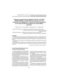
F. González,S. Kaiser, S. Merino, M. Huesca, A. Roldán, J.M. Cuevas y G. VenturaTable 2. Description of the GLC-based legend used for the classification of the AWiFS and MERIS Images.was trained using 100% of the <strong>de</strong>lineated ROIs.(iv) The accuracy analysis of the first classificationwas performed using those ROIs that had not beenused for training, as mentioned before. The secondclassification was analysed using the same ROIs thathad been used for training. This second step wasdone supposed that the accuracy would be higher orat least equal to the classification trained with 50%of the ROIs.The latter classification was finally compared tothe 3-NFI and CLC2000 maps and with a MERIS-FR-based classification of the study area performedby García-Gigorro et al. (2007). The methodologyemployed to obtain the MERIS-FR product was similarto the one <strong>de</strong>scribed in this work.RESULTS AND DISCUSSIONNine LULC classes were consi<strong>de</strong>red for the provinceof Madrid. The classes are mentioned in thelegend of figure 2 and explained in more <strong>de</strong>tail intable 2. Figure 2.1 shows the two land cover maps tobe compared for the province of Madrid – the onebased on AWiFS data (A) and the one based onMERIS-FR imagery (B). Figure 2.2 shows theAWiFS classification in comparison with the 3-NFIand CLC2000 reference cartographies. Table 3 provi<strong>de</strong>san overview of land cover class surfaces forall the three products.The overall and class accuracies for the classificationsbased on AWIFS and MERIS, using 50% ofROIs as trainers and 50% for validation, are compiledin table 4.88Revista <strong>de</strong> Tele<strong>de</strong>tección. ISSN: 1988-8740. 2008. 30: 85-91
Comparing AWIFS and MERIS images for land use-land cover mapping in SpainFigure 2. Classification results for AWiFS and MERIS_FR data and comparison with reference maps.Table 3. Comparison of relative class surfaces (%) for different cartographies. For 3-NFI forest cartography, non forest surfacesare not consi<strong>de</strong>red.Revista <strong>de</strong> Tele<strong>de</strong>tección. ISSN: 1988-8740. 2008. 30: 85-91 89
Comparing AWIFS and MERIS images for land use-land cover mapping in Spainreference cartographies. The lower cost of MERIS-FR imagery has to be taken into account as well.CONCLUSIONSThe results reached so far suggest that AWiFS imagesas a good source of information for land covermapping. Nevertheless, although accuracies obtainedfor AWIFS classifications are higher, MERISdata may be more a<strong>de</strong>quate for some types of surfaces.If a forest map is to be <strong>de</strong>veloped at Europeanscale, the characteristics of each country’s land covertypes have to be carefully analyzed to <strong>de</strong>terminewhether it is worth assuming the higher cost andmore laborious process of using AWIFS instead ofMERIS-FR to reach the proposed goals.Important differences appear when comparing theclassification product with the reference data, mainlydue to the conflict land use vs land cover classes andthe difficulty to achieve compatible legends. Itwould be useful to reach an agreement for the use ofa global land use and land cover legend. Classesshould be adaptable to the specific characteristics ofthe different countries involved in global scale projects.ACKNOWLEDGEMENTSThe authors would like to thank ESA for free dataprovision through the approved Category-1 projectentitled “An Assessment on the potential of Spanishforests as carbon sinks using remote sensing techniques”.This work was also possible thanks to anagreement between the Spanish Ministry of Environmentand the INIA – Ministry of Education andScience. Special thanks to the Spanish National GeographicInstitute (IGN) for helping us in the use ofthe CORINE Land Cover product and to Banco <strong>de</strong>Datos <strong>de</strong> la Naturaleza for supplying NFI data andcartography.REFERENCESromap.<strong>de</strong>/docs/doc_005.html (accessed 15-03-2006)ESA, 2006, Envisat instruments. Available onlineat: http://envisat.esa.int/instruments/meris/(accessed 15-03-2006)INSTITUTO GEOGRÁFICO NACIONAL, 2002.Corine 2000. Descripción <strong>de</strong> la nomenclatura<strong>de</strong>l Corine Land Cover al nivel 5º. Ministerio<strong>de</strong>l Fomento.INSTITUTO GEOGRÁFICO NACIONAL,Nov.2004. Actualización <strong>de</strong> la base <strong>de</strong> datos<strong>de</strong> Corine Land Cover, ProyectoI&CLC2000, Informe Final. Ministerio <strong>de</strong>Fomento (Madrid).JOINT RESEARCH CENTER, 2006, IES. Onlineat: http://ies.jrc.cec.eu.int/31.html (accessed28-04-2006)JOINT RESEARCH CENTRE – TERRESTRIALECOSYSTEM MONITORING, 2006. Availableonline at: http://www-tem.jrc.it/Mapping_land_cover/activities/globcover2005.htm (accessed 30-04-2006)MAPA - Ministerio <strong>de</strong> Agricultura, Pesca y alimentación,2006, Sigpac Visor. Available onlineat: http://sigpac.mapa.es/fega/visor/ (accessed04-2006)MINISTERIO DE MEDIO AMBIENTE, 2004. TercerInventario Forestal Nacional, 1997-2007,Comunidad <strong>de</strong> Madrid. Ministerio <strong>de</strong> MedioAmbiente (Madrid).NATIONAL REMOTE SENSING AGENCY, 2006,IRS–P6 / RESOURCESAT–1. Available onlineat:http://www.nrsa.gov.in/engnrsa/p6book/system/system<strong>de</strong>script.htm (accessed 15-03-2006)GARCÍA-GIGORRO, S., GONZÁLEZ-ALONSO,F., MERINO DE MIGUEL, S., ROLDAN-ZAMARRON, A., CUEVAS, J.M. 2005.MERIS-FR potential for land use – landcover mapping in Spain. International Journalof Remote Sensing, 28(6): 1405-1412.CORINE, 1993. CORINE land cover – Gui<strong>de</strong> technique.(Bruxelles: Comission <strong>de</strong>s CommunautéesEuropéennes).DUP-ESA, 2006, Globcover. Available online at:http://dup.esrin.esa.it/projects/summaryp68.asp (accessed 28-04-2006)EUROMAP, 2006, Indian Remote Sensing Satellite,IRS-P6. Available online at: http://www.eu-Revista <strong>de</strong> Tele<strong>de</strong>tección. ISSN: 1988-8740. 2008. 30: 85-91 91