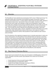
Hillsborough River Bathymetry Map Below 40th St.
Hillsborough River Bathymetry Map Below 40th St.
Hillsborough River Bathymetry Map Below 40th St.
- No tags were found...

Create successful ePaper yourself
Turn your PDF publications into a flip-book with our unique Google optimized e-Paper software.
221622662106100<strong>Hillsborough</strong>Reservoir(South)Section - Township - Range20, 29, 32 & 33-28-1922820Contour LinesExpressed in2-Foot Intervals2010241286610222464626664368121242001061022682288081220Reservoir PerimeterGround LevelEXPLANATION:Survey Date: June 2, 2009Reservoir water level was 22.78 ft above see level attime of the assessment at USGS 02304500.Contours are expressed in absolute depthbelow this level.RESERVOIR MORPHOLOGY:Perimeter 26,234.18 ft;Area 167.18 AcresMean Depth 10.11 ft;Volume 67,730,980.3 Acre-ft, (506,666,429 gallons);Deepest point 37.36 ftDATA SOURCES:2007 aerial photography provided by theSWFWMD.<strong>River</strong> perimeter digitized from SWFWMD2007 aerial photographs.All contours generated by the Florida Centerfor Community Design and Research fromsurvey data collected by USF Lake and<strong>St</strong>ream Assessment Program.DISCLAIMER:This map is for illustrative purposes only,and should not be used for lake navigation.Feet0 125 250 500 750 1,000