ORAL - International Conference of Agricultural Engineering
ORAL - International Conference of Agricultural Engineering
ORAL - International Conference of Agricultural Engineering

You also want an ePaper? Increase the reach of your titles
YUMPU automatically turns print PDFs into web optimized ePapers that Google loves.
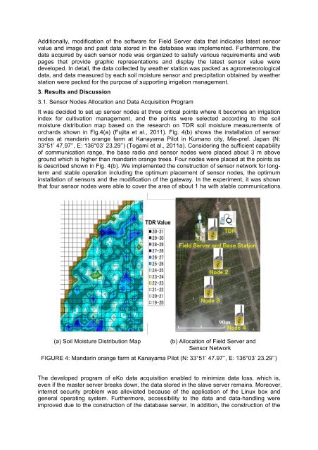
Additionally, modification <strong>of</strong> the s<strong>of</strong>tware for Field Server data that indicates latest sensorvalue and image and past data stored in the database was implemented. Furthermore, thedata acquired by each sensor node was organized to satisfy various requirements and webpages that provide graphic representations and display the latest sensor value weredeveloped. In detail, the data collected by weather station was packed as agrometeorologicaldata, and data measured by each soil moisture sensor and precipitation obtained by weatherstation were packed for the purpose <strong>of</strong> supporting irrigation management.3. Results and Discussion3.1. Sensor Nodes Allocation and Data Acquisition ProgramIt was decided to set up sensor nodes at three critical points where it becomes an irrigationindex for cultivation management, and the points were selected according to the soilmoisture distribution map based on the research on TDR soil moisture measurements <strong>of</strong>orchards shown in Fig.4(a) (Fujita et al., 2011). Fig. 4(b) shows the installation <strong>of</strong> sensornodes at mandarin orange farm at Kanayama Pilot in Kumano city, Mie-pref. Japan (N:33°51’ 47.97’’, E: 136°03’ 23.29’’) (Togami et al., 2011a). Considering the sufficient capability<strong>of</strong> communication range, the base radio and sensor nodes were placed about 3 m aboveground which is higher than mandarin orange trees. Four nodes were placed at the points asis described shown in Fig. 4(b). We implemented the construction <strong>of</strong> sensor network for longtermand stable operation including the optimum placement <strong>of</strong> sensor nodes, the optimuminstallation <strong>of</strong> sensors and the modification <strong>of</strong> the gateway. In the experiment, it was shownthat four sensor nodes were able to cover the area <strong>of</strong> about 1 ha with stable communications.(a) Soil Moisture Distribution Map(b) Allocation <strong>of</strong> Field Server andSensor NetworkFIGURE 4: Mandarin orange farm at Kanayama Pilot (N: 33°51’ 47.97’’, E: 136°03’ 23.29’’)The developed program <strong>of</strong> eKo data acquisition enabled to minimize data loss, which is,even if the master server breaks down, the data stored in the slave server remains. Moreover,internet security problem was alleviated because <strong>of</strong> the application <strong>of</strong> the Linux box andgeneral operating system. Furthermore, accessibility to the data and data-handling wereimproved due to the construction <strong>of</strong> the database server. In addition, the construction <strong>of</strong> the