Chirk Part 1 of 2 - PDF format 2.8Mb - Wrexham County Borough ...
Chirk Part 1 of 2 - PDF format 2.8Mb - Wrexham County Borough ...
Chirk Part 1 of 2 - PDF format 2.8Mb - Wrexham County Borough ...
- No tags were found...

You also want an ePaper? Increase the reach of your titles
YUMPU automatically turns print PDFs into web optimized ePapers that Google loves.
CONTENTSChapterPage1. Introduction 12. Location 33. Origins and Development 44. Local Planning Issues 95. Summary <strong>of</strong> Special Character 136. Special Interest 15The Sub-AreasSub-Area 1 16Holyhead Road NorthSub-Area 2 20Holyhead Road SouthSub-Area 3 24Station AvenueSub-Area 4 28Church StreetSub-Area 5 36Castle Road and Trevor Road7. Problems within the Conservation Area 418. General Enhancement 43ProposalsGlossary <strong>of</strong> Technical TermsThe Hand HotelAppendices
Hawk House, <strong>Chirk</strong> Castle groundsSpecial thanks to Graham Greasley forpermission to use his pictures <strong>of</strong> old <strong>Chirk</strong> inthis document
conservation areas is incorporated in two sets <strong>of</strong>guidance (see Appendix 1). Both highlight theneed for strong conservation area policies in theINTRODUCTION 1local plan, which should be based on a cleardefinition <strong>of</strong> its special architectural or historicinterest. A review strengthens and justifies definition <strong>of</strong>Aim <strong>of</strong> the <strong>Chirk</strong> ConservationArea AssessmentConservation Areas are ‘areas <strong>of</strong> specialarchitectural or historic interest, the characteror appearance <strong>of</strong> which it is desirable topreserve or enhance’.the conservation area's special character andallows a strategy to be developed that willcreate a clear context for future development.As an adopted Council document, it is a point <strong>of</strong>reference for <strong>of</strong>ficers when exercising itsplanning duties and grant-giving powers. Thisshould lead to a higher quality built environmentPlanning (Listed Buildings and ConservationAreas) Act 1990as a result <strong>of</strong> more informed decision-making by<strong>of</strong>ficers, developers and householders.Local Authorities are required by law to designateconservation areas and to formulate policies andproposals for their preservation and enhancement.<strong>Chirk</strong> Conservation Area was designated on theA Conservation Area Enhancement Plan will beproduced at a later date, with detailed policies forthe improvement <strong>of</strong> the conservation area and willbe subject to public consultation.29th August 1975 and was reviewed on 6thOctober 1997 where boundary changes wererecommended and approved.The purpose <strong>of</strong> the above is to promote andsupport developments that are in keeping with, orenhance, the character <strong>of</strong> <strong>Chirk</strong> Conservation Area.The boundary review and character assessment isthe first to be undertaken since its designation.The purpose <strong>of</strong> it is as follows:- Conservation Areas are designated under theThey are not attempts to stifle change. The aim isto strike the right balance so that the interests <strong>of</strong>conservation are given their full weight against theneed for change and development. This also meetsthe Council's responsibility for preserving andPlanning (Listed Building and Conservationenhancing the character and appearance <strong>of</strong> theWar MemorialAreas) Act 1990. Government policy onConservation Area.1
About Conservation AreasDesignating a Conservation Area is a matter for theLocal Planning Authority and is one made againstlocally related criteria. 'Quality <strong>of</strong> place' or 'localdistinctiveness' is the prime consideration.The character <strong>of</strong> the Conservation Area can derivefrom many factors including individual buildings,building groups and their relationship with spaces,architectural detailing, materials, views, colours,landscaping, street furniture and so on. It may alsodraw on sounds, local environmental conditions orhistorical changes. These qualities may changethroughout the course <strong>of</strong> the day and night. Suchelements <strong>of</strong> character cannot be directlysafeguarded. However, by protecting the buildingsand spaces formed between them, it is more likelythat the activities and uses that make up thecharacter <strong>of</strong> a place can be sustained.2Holyhead Road, 1905
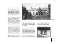
within the private garden <strong>of</strong> The Mount, it wasclearly sited to control access up the valley andprobably remained in use until the building <strong>of</strong> the4ORIGINS AND DEVELOPMENT 3The area known as <strong>Chirk</strong> is rich in history.Medieval battles, Welsh and English warlords,influential families, religion and past and presentindustry have all played important roles inshaping its character in the North Walesborderlands. Also <strong>of</strong> importance is thetopography, which has also influenced its originsand development. Due to such features the towncentre core, where the Conservation Area islocated, has distinctive architecture, buildingmaterials and landscape that has created thecharacter <strong>of</strong> the Conservation Area.<strong>Chirk</strong> is on the eastern edge <strong>of</strong> a bleak landscape,which may explain the historic settlement pattern <strong>of</strong>both a military and domestic nature for strategy andhabitation. In the first Century the Romansestablished a former Vexillation camp at WesternRhyn just to the south <strong>of</strong> <strong>Chirk</strong>, which was used asa base for armies bound for Snowdonia. The eighthCentury reputedly saw the Kings <strong>of</strong> Mercia createWat's and Offa's Dyke. The location <strong>of</strong> <strong>Chirk</strong> townitself, however, is linked to the earthen Norman12th Century motte on the edge <strong>of</strong> the Dee valleyto the south <strong>of</strong> St Mary's Church. Now enclosedpresent <strong>Chirk</strong> Castle. The position and extent <strong>of</strong>any likely bailey or courtyard attached to the motteis unknown. In 1391, a recording <strong>of</strong> some buildingsin the area suggests demesne buildings. Theseincluded a chapel, hall, chamber, grange and barns.The hall and chapel may have been located to thewest <strong>of</strong> the Church on the corner <strong>of</strong> Church Streetand Castle Road at Bryn Eglwys. Some survivingmasonry in the cellars at Bryn Eglwys supports this.Rear <strong>of</strong> Bryn Eglwys, Castle RoadChurch <strong>of</strong>St Mary’s<strong>Chirk</strong> is a reputed, ancient, Welsh-dominated,religious stronghold. This, plus the location <strong>of</strong> themotte and demesne buildings, may have been afactor in the siting <strong>of</strong> the early 12th Century Church<strong>of</strong> St Mary. The church was originally dedicated toSt Tysilio, a Welsh saint, who also had a Christianburial ground dedicated to him. It is constructed <strong>of</strong>yellow sandstone from the Upper coal measures,probably from outcrops near the current <strong>Chirk</strong>Castle estate. It has a chancel and nave, <strong>of</strong> whichpart <strong>of</strong> the original has been incorporated into laterbuilding works, highlighted by the residual pilasterbuttresses. A wider section incorporates a roundarched south door, now blocked, behind a 19thcentury buttress.The 13th Century was a crucial time in thedevelopment <strong>of</strong> the town. During this time the landsaround <strong>Chirk</strong> became controlled by the WelshPrince Gruffydd ap Madoc. The Prince is reputed tohave founded Valle Crucis Abbey in Llangollen, yethe was a stalwart supporter <strong>of</strong> Norman England.However, his son Llywelyn, was <strong>of</strong> a more patrioticnature, and wished to exert a stronger Welshinfluence in the area. With de Montfort, an English
ebel, an attempt was made to seize <strong>Chirk</strong>. Thiscaused grave personal conflict to his father. Largelyas a result <strong>of</strong> Llywelyn's failed attempt, <strong>Chirk</strong> wasseized by Edward I, who bequeathed it in 1272 toRoger Mortimer <strong>of</strong> Wigmore. Mortimer subsequentlybuilt the new <strong>Chirk</strong> Castle between 1295 and 1310,a mile to the west <strong>of</strong> the Norman motte. Theabandoning <strong>of</strong> the motte meant inevitably that itwould fall into decay and ruin. <strong>Chirk</strong> Castle doesnot appear to have been placed in a strategicmilitary site; however, its original gateway facedwest to the Ceiriog Valley, so any Welshman wouldbe immediately aware <strong>of</strong> <strong>Chirk</strong>'s allegiance to theEnglish crown.The town <strong>of</strong> <strong>Chirk</strong> was carefully planned aftermilitary defences were in place and was similar toseveral townships under Edwardian control inWales, such as Denbigh, Ruthin and Rhuddlan. Itwas granted a market charter and, in 1324 (orpossibly earlier in 1282), <strong>Chirk</strong> became a freeborough with burgages (holdings <strong>of</strong> land with adwelling place). In 1391 23 were recorded. Todaythe plots and medieval grid iron street pattern in thecentral core <strong>of</strong> the town have now largelydisappeared. This is probably a result <strong>of</strong> naturalevolution, the campaigns <strong>of</strong> Owain Glyndwr - thelast Welsh prince - in the early 15th Century andTelford's road building in the 19th Century.Certainly the campaigns <strong>of</strong> Glyndwr in the 1402uprising had the first devastating impact on thetown, which included the decimation <strong>of</strong> the hall andchapel at Bryn Eglwys. In 1530 the travel writerLeland noted only a few houses in <strong>Chirk</strong>. Certainlyfrom that description there seemed little in the wayWhitehurstGardengatepiers<strong>of</strong> the once thriving market town <strong>of</strong> Edward I,despite the fact that it had been granted a newmarket charter in 1506.Events in the 17th Century also had an influenceon the landscape <strong>of</strong> <strong>Chirk</strong>, including the Civil War <strong>of</strong>1642 -7, where land cultivation occurred as moreintensive farming measures were undertaken forfood supplies for soldiers. <strong>Chirk</strong> Castle wasdamaged - not by shelling, but by brute force asrevenge for allegiance switching by the Myddletonfamily, who owned the castle at that time.During the 17th century, Sir Thomas Myddletoncreated Whitehurst Gardens at the north end <strong>of</strong><strong>Chirk</strong>. This was built as a pleasure garden forhimself and important guests, such as MajorGeneral James Berry, Duke <strong>of</strong> Beaufort; the LordPresident <strong>of</strong> Wales; and various circuit judges.<strong>Chirk</strong> Castle5
6The gardens included a banqueting house, asummerhouse, an orangery, deer and fishponds,fruit and vegetables such as figs and asparagusand a boathouse. The garden eventually fell intodecline, and by 1931 became part <strong>of</strong> land used forcolliery housing for Black Park, but the walls,terrace and impressively large mount survive. In2001 plans began to repair the listed structures atWhitehurst.There was also an element <strong>of</strong> urbanisation in the17th, 18th and 19th century in <strong>Chirk</strong>. Numerousinfluential landowners and industrialists such as theMyddletons, Trevors, Kynastons, Myttons, Eytonsand the Wards exploited local mineral reservessuch as iron, coal, slate, limestone and clay. Theinflux <strong>of</strong> men with money to the town - sometimesfrom far afield - may have had an impact on thearchitectural character <strong>of</strong> the town centre. By themiddle <strong>of</strong> the 18th century, it appears that theGeorgian architectural style gained influenceamongst the local gentry and industrialists,replacing the vernacular style <strong>of</strong> house building.Good Georgian examples in the town include TheMount at the southern end <strong>of</strong> Church Street, andthe Hand Hotel. Telford's A5 road from London toDublin was built at the beginning <strong>of</strong> the 19thCentury, which widened the road and setmilestones along the route, significantly altering theoriginal layout <strong>of</strong> medieval <strong>Chirk</strong>. It also createdbusiness opportunities in the town centre,particularly in the form <strong>of</strong> hostelries and inns. Mosthave now largely disappeared or have beenextensively remodelled.The 19th Century also introduced the Victorian code<strong>of</strong> moral and social responsibility to the town. Thismanifested itself in a number <strong>of</strong> buildings. CharlotteMyddleton-Biddulph <strong>of</strong> <strong>Chirk</strong> Castle Estate had asignificant influence in this. She commissioned thePicturesque Hand Terrace, estate workers cottagesbuilt in 1820 - 5, and the Neo Elizabethan FormerNational Girls School <strong>of</strong> 1843 - 4 by Augustus Pugin,co-architect <strong>of</strong> the Houses <strong>of</strong> Parliament, 'with anaptness <strong>of</strong> style to function'.The aqueduct and viaductOutside the town centre the great advances intransport and communication in the 18th and 19thCentury led to the construction <strong>of</strong> the magnificentaqueduct and viaduct to the south west <strong>of</strong> <strong>Chirk</strong>.Designed by Telford and Henry Robertsonrespectively, these great engineers effectively andelegantly spanned the Ceiriog Valley to createstunning pieces <strong>of</strong> architecture in yellow sandstone,whilst furthering the canal and rail networksrespectively. The viaduct was built deliberately
higher than the aqueduct to emphasis thesuperiority <strong>of</strong> rail over water.The later 19th and earlier 20th Century expansion <strong>of</strong>the town was piecemeal. The significant buildingstyle <strong>of</strong> this period in <strong>Chirk</strong> belongs to theEdwardian era. <strong>Chirk</strong> Town Council Offices onHolyhead Road is an excellent example <strong>of</strong> a neo-Jacobean domestic style public building in theEdwardian period. The War Memorial on thejunction <strong>of</strong> Holyhead and Station Road is particularlyremarkable. It was commissioned by Lord Howardde Walden <strong>of</strong> <strong>Chirk</strong> Castle and designed by thenoted designer and sculptor Eric Gill, after WorldWar I. The austerity <strong>of</strong> the form, the pathos <strong>of</strong> thefigured relief and the spare elegance <strong>of</strong> the letteringhave achieved great dignity. Also <strong>of</strong> note is BrynCoed in Castle Road, built in 1912 by Shayler andEridge, architects for A. Wood, a manager forBrynkinallt Colliery, in a Restoration revival style. Noless significant are the Edwardian properties liningStation Road, with a simple restrained decorationthat has been largely unaltered.The later 20th Century has seen political changesin local government, which has perhaps led todiffering aspirations and approaches to the town.Before 1974 it was governed locally, from CastleRoad. From 1974 to 1996 it fell under theadministration <strong>of</strong> Glynd@r District Council, based inRuthin, within Clwyd <strong>County</strong>. From 1996 <strong>Wrexham</strong><strong>County</strong> <strong>Borough</strong> Council has administered the area.The town centre is the main commercial core <strong>of</strong><strong>Chirk</strong>. Today it is recognised as an importantneighbourhood shopping centre, covering a diverserange <strong>of</strong> goods and services, with approximately 30businesses currently located there, to support apopulation <strong>of</strong> almost 4000 in <strong>Chirk</strong> community itself,but also a wider community in the Ceiriog valley <strong>of</strong>approximately 2000. However, the vitality andviability <strong>of</strong> the town has been threatened in recentyears. This is partly as a result <strong>of</strong> the followingpertinent issues: - low tourism visits to town centre, despite itsfundamental but unrealised architectural beautyand character and the proximity to nearby touristattractions, such as the castle (owned by theNational Trust) and canal; re-routing <strong>of</strong> the main transport route, althoughthis has resulted in a reduction in traffic and anincrease in the quality <strong>of</strong> the environment;Thomas TelfordBryn Coed<strong>Chirk</strong> Castle gates7
inappropriate replacement <strong>of</strong> traditionalmaterials, both to historic buildings and thewider townscape; and poor quality development after World War Two.Some examples <strong>of</strong> mirroring historic form andfeatures in the town centre have beenparticularly unsuccessful.These factors could result in the decline <strong>of</strong> the overallarchitectural townscape, which, with other key factorssuch as a secure economic base and tourism, arevitally important in attracting the community,businesses and visitors to this unique town.historic park and garden, but a large section <strong>of</strong> itsland has been scythed by the A483 by pass from<strong>Wrexham</strong> to Oswestry.Approximately 10% <strong>of</strong> the population <strong>of</strong> <strong>Chirk</strong> speakWelsh. However, in the Ceiriog Valley, where <strong>Chirk</strong>is seen with Oswestry as the nearest shoppingdistrict, the figure is over 50%. Bilingual signage isevident to the highways, but private signage showslittle evidence <strong>of</strong> this.This Character Assessment highlights the overallqualities <strong>of</strong> the Conservation Area. It identifiesbuildings and areas that require preservation andenhancement. It is not intended to be comprehensiveand the omission <strong>of</strong> any particular building, feature orspace does not mean that it is <strong>of</strong> no interest.The main land uses are retail and commercial atthe heart <strong>of</strong> the Conservation Area and residentialto roads outwith the main spine <strong>of</strong> the A5. Adjacentlandscapes to the Conservation Area have aninfluence its setting. To the north is an extensive20th century residential area, and beyond isWhitehurst, a registered Historic Park and Garden.8A significant industrial area to its north westseparates the town from part <strong>of</strong> its medievalheritage in the form <strong>of</strong> <strong>Chirk</strong> Castle, and thesurrounding countryside. This includes the site <strong>of</strong>Kronospan. <strong>Chirk</strong> Castle is a Grade I listed buildingwith a Historic Park and Garden owned by theNational Trust. To the south west is the RiverCeiriog valley with its listed aqueduct and viaduct,which are <strong>of</strong> outstanding aesthetic value.Brynkinallt Estate lies to the east, also with anBrynkinallt Hall
o<strong>of</strong> <strong>of</strong> a dwelling house may require planningpermission. Demolition may require ConservationArea Consent, or tree pruning and removal mayLOCAL PLANNING ISSUES 4require Consent for Work to Trees. Controls inConservation Areas are not intended as ahindrance to change, but as positive management<strong>of</strong> change.Planning PolicyThe local planning development framework iscontained in the 'Glynd@r District Local Plan',which became operative in February 1994. PoliciesC1, C3 to C6, C8, C9, C11 to C15 are mostrelevant. They give priority to preservation andenhancement <strong>of</strong> those features within ConservationAreas that contribute to their unique character. Thisincludes Listed Buildings and Scheduled AncientMonuments. Policies A1, L9, S1, S2 and T9 arealso relevant. Reference must also be had to theClwyd <strong>County</strong> Council Structure Plan (FirstAlteration).The outward appearance <strong>of</strong> all properties inConservation Areas is vitally important. Ownersshould bear in mind that inappropriate alterationand the removal <strong>of</strong> traditional detail could have anegative impact on the building and theConservation Area. Such alterations do not usuallyincrease the value <strong>of</strong> a property and may make itmore difficult to sell.You are advised to discuss any proposals with aplanning <strong>of</strong>ficer, who will be able to advise youwhether planning permission is required or not.Listed Buildings and Tree Preservation Ordersrequire separate consents for any works affectingthem. There is no fee required for Listed BuildingConsent, Conservation Area Consent, or Consentfor Work to Trees.Outline planning applications are not usuallyaccepted for sites within Conservation Areassince the level <strong>of</strong> detail provided is rarelyadequate. Detailed plans are always required fornew development, and pre-application advice onproposals is always encouraged.CheersOff LicenceThe emerging <strong>Wrexham</strong> Unitary DevelopmentPlan - Forward to 2011 will also be a materialconsideration in determining planning applicationsaffecting the site, and will eventually supersede theGlynd@r District Local Plan and the Structure Plan.Planning ControlManaging change in Conservation AreasIn order to protect its special character, certaincontrols exist, which are over and above normalplanning permission. Alterations to the walls andCoronation OakConservation ProtectionThe community <strong>of</strong> <strong>Chirk</strong> was resurveyed by CADWin 1998 and 99 buildings are now listed. Within<strong>Chirk</strong> Conservation Area there are 25 ListedBuildings and structures. One building is listedGrade I, one structure is listed Grade II* and theremainder <strong>of</strong> the buildings listed Grade II. Adding tothe area's rich history are three Scheduled AncientMonuments and two Tree Preservation Orders in oradjoining the Conservation Area, covering 34 trees.One also covers Doctors Wood to the south.9
LISTED BUILDINGS AND SCHEDULED ANCIENT MONUMENTSBuilding Name & Address, Origins Reason for Listing (and Other Points <strong>of</strong> Interest) Current UseGrade and Date <strong>of</strong> ListingThe Church <strong>of</strong> St Mary 12th Century nave Important survival <strong>of</strong> early fabric in a church which largely retains its medieval ChurchGrade I and chancel, with character, its fine carved late - medieval ro<strong>of</strong>s, and internal fittings including the1966 additions and outstanding group <strong>of</strong> 18th Century monuments & memorials.alteration in the Served as family repository for the local Myddleton and Trevor Estates16th - 19th Yellow sandstone, slate ro<strong>of</strong>. Twin naves. Some 15th Century windows with cuspedCenturiesheads to south nave. Later north nave.Interior has very small chancel and reredos, possibly Norman. Now dominated by finelycarved memorials to the Myddleton family.Lychgate to above Church 1923 A well designed lychgate. Of group value with the Church <strong>of</strong> St Mary. LychgateGrade II , 1998Timber framed, sandstone walls, stone slab ro<strong>of</strong>. Trefoiled head.Sundial to above Church 1827 A complete sundial in a style typical <strong>of</strong> its period, <strong>of</strong> group value with the Church. SundialGrade II, 1998Tall octagonal sandstone pillar. Deeply cut roll-moulded lancet rising to a pointed arch.Ward Monument in c.1854 A good example <strong>of</strong> a mid-Victorian graveyard monument to an important local Monumentabove Churchyardindustrialist, <strong>of</strong> group value with the Church.Grade IIOpen chest, painted sandstone. Wide side cusped arch, hollow spandrels. Cast iron1998 railings, cross-laced, fleur terminals.Trevor Mausoleum in c.1905 A fine and elaborate example <strong>of</strong> Neo-Norman design, employed at a later date Mausoleumabove ChurchyardNeo-Norman, sandstone, stone slab ro<strong>of</strong>. Dressed clasped buttresses to corners.Grade IIString course, corbel table supporting stone gutter. Interior has life-size white winged1998 angel standing on small hemisphere, tenderly carrying Mary Rosamund aged five,Baron Trevor's child.The Mount 1753 A handsome Georgian Townhouse, vital to the south visual enclosure FlatsChurch Street<strong>of</strong> the street.Grade IIOnce boys school. Flemish bond brick, slate ro<strong>of</strong>. Three storey. Central panelled door1966 and overlight. 16 pane sash windows. Lead hopper. Iron railings.Hand Hotel Mid 18th Century A fine example <strong>of</strong> a 18th Century hostelry with contemporary fenestration. HotelChurch StreetFlemish bond red brick, stone plinth and sill bands, slate ro<strong>of</strong>. Three storey. CentralGrade II, 1976Tuscan portico entrance. 12 pane sash windows. Cast iron bracket to sign.10
LISTED BUILDINGS AND SCHEDULED ANCIENT MONUMENTSBuilding Name & Address, Origins Reason for Listing (and Other Points <strong>of</strong> Interest) Current UseGrade and Date <strong>of</strong> Listing1-7 Hand Terrace c1820 - 1825 A good example <strong>of</strong> estate cottages retaining original detailing, built with an apt DwellingHolyhead Roadsense <strong>of</strong> scale and forming a picturesque composition, carefully fitting into theIndividually listed as Grade IIexisting fabric at <strong>Chirk</strong>1998 Terrace <strong>of</strong> 7 estate workers cottages, brick, roughcast, slate ro<strong>of</strong>s. 1 storey and attic.3 forward wings contain cottages 1,4 and 7. Continuous slated open veranda. Gothicpointed arched boarded doors with window style to match.<strong>Chirk</strong> Furniture & Carpet Centre 1843 - 4 A carefully designed elementary school, and interpreting demonstration <strong>of</strong> Shop/dwellingand DwellingA W N Pugin's ability to achieve a fine architectural solution to even the smallestHolyhead Roadcommission; the careful ability <strong>of</strong> plan and the aptness <strong>of</strong> style to function standGrade IIout as Puginian principles. The 1905 extension to the north respects the scale and1973 detail <strong>of</strong> the original work.Former National Girls School. Altered and extended. Neo Elizabethan. Sandstone,slate ro<strong>of</strong>. Stone mullion windows, some with transoms. Pronounced kneelers to gables,one with bellcote.<strong>Chirk</strong> Town Council Offices 1902 A well detailed building in its original condition, an excellent example <strong>of</strong> the OfficesHolyhead Roadprovision <strong>of</strong> fine public buildings in small towns in the Edwardian period.Grade IIJacobean revival style. Sandstone, red tiled ro<strong>of</strong>. Central two-storey porch with raised1998 Tuscan columns and balustrade. Shield in strapwork cartouche. 2 storey projectingmullioned and transited stone bay windows. Double panelled doors, fanlight.North and south gatepiers 1902 <strong>Part</strong> <strong>of</strong> the design <strong>of</strong> the Council Offices Gatepiersto above OfficesGatepiers contemporary to original design. Sandstone blocks, each course alternating inEach listed at Grade II, 1998size and rising to cornice, pedestal, ball finial. Missing iron gates.War Memorial 1919 - 20 A remarkable war memorial by a pre-eminent British sculptor and designer. War MemorialStation Avenue Eric Gill designed the memorial. A further inscription was added after 1945.Grade II*Simple tapered square obelisk, Portland stone. Bas - relief hunched figure <strong>of</strong> great1998 coated, helmeted soldier holding rifle and bayonet. Elegantly lettered inscription to menwho died in battle in 1914 - 1918, and 1939 - 1945.11
LISTED BUILDINGS AND SCHEDULED ANCIENT MONUMENTSBuilding Name & Address, Origins Reason for Listing (and Other Points <strong>of</strong> Interest) Current UseGrade and Date <strong>of</strong> ListingSt Michael Nursing Home 1853 A good example <strong>of</strong> a large mid-Victorian vicarage in simple Tudor Gothic style, Nursing HomeTrevor Roadespecially to fenestration and chimneys and expressive planning.Grade IIThe building became a nursing home in 1983 after the construction <strong>of</strong> a new smaller1998 vicarage next door. Yellow sandstone, slate ro<strong>of</strong>, steeply pitched coped gables. Tudorarch entrance porch. Mullion and transom windows with heavily moulded timber framesin chamfered stone surrounds.Trevor House C17 An important house with an interesting history. Dwelling HouseTrevor RoadMay be house known as Plas Iva, first mentioned in 1660. Slate ro<strong>of</strong>, timber framing toGrade II , 1998rear that forms irregular L plan. Front elevation has four paned C19 sash windows.Milestone 1894 A milestone <strong>of</strong> interest with a late 19th Century plate in miles and furlongs. MilestoneCastle RoadMay belong to earlier series <strong>of</strong> turnpike milestones on Holyhead Road. Stone, roundedGrade II, 1998top, cast iron plate.1 Castle Road 17th Century A prominent urban group at the centre <strong>of</strong> <strong>Chirk</strong>. Dwelling HouseGrade IIOne <strong>of</strong> a row <strong>of</strong> 4, all refaced in brick in the early - mid 19th Century. Slate ro<strong>of</strong>, 2 storey.1998 C19 gabled timber framed porch on brackets. Stone cills and plinth<strong>Chirk</strong> Surgery, 17th Century 2 storey, with porch to match No. 1. Timber small paned windows in openings. Rear Doctor's Surgery2 Castle Road largely stone, with upper storey timber framed. Outbuildings.Grade II, 1998Bryn Eglwys 17th Century As above, with three storeys. Small paned iron windows to attic. Dwelling House3 Castle RoadGrade II, 1998Bryn Coed 1912 A fine example <strong>of</strong> the late 19th and early 20th century Restoration Revival style Dwelling HouseCastle RoadCentral bay altered in 1916, service end added later in a matching style. Ruabon purpleGrade IIred brick, slate ro<strong>of</strong>, timber dentilled eaves cornice. 2 storey. Main wings have 12 paned1998 sash windows. Recessed central bay has single storey entrance with central door inlimestone frame.12
Building materials are also important, with yellowsandstone principally used in larger buildingsdesigned for the community such as the Church,SUMMARY OFSPECIAL CHARACTER 5The special character <strong>of</strong> the Conservation Areadraws on its Georgian, Victorian and Edwardianbuilding styles to create its distinctive character.The relationship between building and landscapingis also very important, seen particularly in the widerstreet scape, larger communal areas and smallercurtilage spaces.The medieval grid iron street pattern createslinear roads, which strongly interrelate with trees inthe townscape. Also important is the strongcollection <strong>of</strong> marker buildings that define roadjunctions.The Hand Hotel and War MemorialCouncil Offices and the former National GirlsSchool, and local warm red brick used for privateresidences. Some buildings have been renderedand painted white. Much <strong>of</strong> the brickwork isconstructed in the Flemish bond style. Laterbuildings are constructed in Ruabon brick, either redor purple. Decoration to buildings is generallyminimal. Instead the features <strong>of</strong> the façade relateprincipally to window and doors styles, patterns andtheir location in the façade. Ro<strong>of</strong>s are generally <strong>of</strong>slate, although some small, red clay tiles exist.Traditional rainwater goods are <strong>of</strong> cast iron, butproperties constructed before the early 19th Centurymay have some <strong>of</strong> lead. Hoppers <strong>of</strong> this period aregenerally fairly decorative, and the date inscribed.Plan form is principally in the form <strong>of</strong> terraces orlarge detached properties which can be seen tosome extent in each sub area. This creates a fairlyregular spatial pattern in the townscape, and therhythm is punctuated by strongly designedbuildings, or building features, such as porches, baywindows and gable detailing. Properties are largelytwo storey, although some three storey exist. Twostorey properties are sometimes as similar in scaleas three storey buildings.Building details are significant. Vertical slidingsash windows in white painted timber, and panelledtimber doors with a fanlight is common to Georgian,Victorian and Edwardian architecture. Vernacularbuildings tend to have multi paned, side hung, castiron windows and boarded tongue and groovedoors. Also important are modestly scaled opengabled porches, typically no larger than the doorhead itself.Boundary detailing is an issue where boundarywalls exist, but a significant number <strong>of</strong> buildings, bothresidential and commercial, directly face the street.They enclose the street by massing and height, andare enhanced by trees or boundary walls.<strong>Chirk</strong> TownCouncil Offices- a sandstonebuilding withred clay ro<strong>of</strong>tiles and castiron guttering13
The landscaping elements are very important tothe character <strong>of</strong> the Conservation Area. There is asignificant amount <strong>of</strong> limes, some poplars andhorse chestnuts. Tree avenues are very distinctiveto <strong>Chirk</strong> and s<strong>of</strong>ten the linear street pattern, addingdiversity to the streetscape.The public realm could be enhanced. Numerousand substantial highway signage is a particularproblem, particularly at road junctions, due to thenecessity <strong>of</strong> bilingual signage and highwaystandards. Poor quality paving undertaken by theprevious local authority has failed to take account <strong>of</strong>buildings or the wider streetscape, and the scale <strong>of</strong>street lighting does not sit comfortably within thestreet. The latter is a legacy from the A5, before theby-pass was built in the mid 1980's. The trees inChurch Street are horse chestnuts which are notindigenous to the area, and their impact has beencompromised by poor tree management in the past.However, since local government re-organisation in1996, <strong>Wrexham</strong> <strong>County</strong> <strong>Borough</strong> Council hasendeavoured to enhance the public realm inConservation Areas when funds have becomeavailable. In 2001, due to funding under the WDA'sSmall Towns and Villages Initiative (STVI), ChurchStreet will be enhanced by using more appropriatepaving materials and creating a better treescape.Despite the wealth <strong>of</strong> mining and quarrying that hastaken place in <strong>Chirk</strong> and the Ceiriog Valley, it doesnot have the historic, neglected and sometimesgrimy industrial character that has occurred in otherareas <strong>of</strong> <strong>Wrexham</strong> <strong>Borough</strong>. It is also quite distinctfrom the flat plains <strong>of</strong> the Maelor in relation totopography, farming practices and ancient manorialsystems. The essence <strong>of</strong> the character is principally<strong>of</strong> a Welsh, rural estate town, important as a bordertown to Wales from England and from the ruralWelsh hinterland to urban <strong>Wrexham</strong>.The Royal Oak,planted by KingGeorge VIin 193714Little new development has taken place in theConservation Area, but inappropriate materialshave weakened design where it has occurred.Horse Chestnuts at Church Street, 1905
Sub-Area 1: Holyhead Road NorthImportant Features:linear development pattern on the eastern side<strong>of</strong> the road;large, architecturally cohesive and visuallyintegrated buildings;similar scale and massing;scale and massing appropriate to past andcurrent uses;dominant building material <strong>of</strong> yellow Cefnsandstone;strong hierarchy <strong>of</strong> space, diminishing in sizefrom the extensive public open space to thewest <strong>of</strong> the road, to large and substantialcurtilage plots to smaller building plots fromnorth to south;focal point created by open space;open space and development creates a pleasingcomposition <strong>of</strong> density and openness; andtrees and vegetation largely confined tocurtilages.This sub area is a linear pattern <strong>of</strong> developmentwhere the character and hierarchy <strong>of</strong> space is a keyfeature. Building mass and frontage detailing in thisarea is important, as it reinforces the legibility <strong>of</strong> thesub-area.The Conservation Area is clearly defined to thenorth by the punctuation <strong>of</strong> grand civic architecturein the form <strong>of</strong> <strong>Chirk</strong> Town Council Offices, set closeto the road. This building, built in yellow sandstoneto a Jacobean revival style, is particularly welldetailed and has suffered little change. Thesymmetry to the front elevation creates a sense <strong>of</strong>rhythm to the building façade, and the imposingcentral two storey ashlar porch with raised Tuscancolumns adds to its sense <strong>of</strong> importance. Also <strong>of</strong>note are the coped gables with square finials andthe substantial stone stacks over the porch andside bays. The treatment to the rear <strong>of</strong> the propertyhas also been addressed by keeping with thefrontage, with mullion and transom windowsbetween raking buttresses to the rear hall. Thehedge curtilage adds a rural dimension to thefinesse <strong>of</strong> stonework and follows the street line.Adjacent is Pugin's glory, the former National GirlsSchool. It is now Shannon Sales Carpet andFurniture Store. It is also <strong>of</strong> coursed, sneckedsandstone with stone mullion windows. Twoprojecting gabled bays to the former school's<strong>Chirk</strong> TownCouncil Offices17
frontage continue the rhythm to the street createdby the symmetry <strong>of</strong> the Town Council Offices. Thepronounced bellcote gable and ornamentalchimney-stacks punctuate the skyline, providing afocal point from the south, seen particularly wellfrom the junction <strong>of</strong> Station Road. Unfortunately, itis obscured by highway signage.<strong>Chirk</strong> Service Station is set at an angle to theroad, with Stanton House Hotel. The garage is a1950's single storey, flat felt-ro<strong>of</strong>ed buildingattached to a vernacular 19th Century two storeyhouse with a Mansard slate ro<strong>of</strong>. This building andthe adjacent hotel were once probably bothsubdivided into two cottages, as illustrated in theOrdnance Survey Map <strong>of</strong> 1872 on page 3. Somevisual harmony is met by the use <strong>of</strong> Cefnsandstone, the retention <strong>of</strong> the buildings' originalrectangular shape, and frontage symmetry byvertically emphasised windows.The loss <strong>of</strong> boundary walls is a problem, as edgesbecome less defined between street and privatespace, which is not appropriate in this area. Thisupsets the continuity <strong>of</strong> the street line and createsan over-familiarity between street and privatespace. A possible sensitive reinstatement mayinclude hinged cast iron / steel railings that couldopen to allow for parking or partial vegetation. Anyexisting cobbles that lie underneath the tarmaccould be reintroduced also. These matters couldeasily be rectified; some possibly with theassistance <strong>of</strong> grant aid.Many <strong>of</strong> the buildings in Holyhead Road are locatedin substantial curtilages with possible scope todevelop to the front and side <strong>of</strong> the property. Greatcare is needed, as it may disrupt the curtilagespace and building dimensions to properties herethat are so characteristic <strong>of</strong> this sub-area.There is scope to extend some properties to therear. However, due to their visibility from CollieryRoad, a sensitive design would be appropriate.18School Mistresses house at Old School HouseOld School House, Holyhead Road
Stanton House in 1950Stanton House Hotel19
Sub-Area 2: Holyhead Road SouthImportant Features: linear development pattern; intimacy, created by development proximity toroad, density <strong>of</strong> development, plot size, modestscale and massing, low ro<strong>of</strong> lines, and theintroduction <strong>of</strong> small front gardens;On the north side <strong>of</strong> the Colliery Road junction is apair <strong>of</strong> semi detached houses. They were likely tohave been built at the same time but differentwindow design has created an Edwardian andVictorian appearance respectively. Originally, thewindows were cast iron and multi paned, and theseshould be reinstated where appropriate. Small frontgardens s<strong>of</strong>ten their setting. Originally they werecottages, but today they form solicitor's <strong>of</strong>fices(identified by an attractive brass plaque to the door)and a former post <strong>of</strong>fice. Semi-octagonal baywindows enhance a townscape rhythm establishedby the buildings in Holyhead Road north. Lean-toopen porches create a similar townscape patternwith verandas to Hand Terrace to its south.Former Post Officeand Solicitorsdiverse, yet complementary historicarchitectural styles, principally Picturesque andEdwardian;the Hand Terrace, which provides a focal point;andvegetation to building curtilages and avenues<strong>of</strong> trees to public areas.The character <strong>of</strong> this sub-area is linear in pattern,yet more intimate than Holyhead Road north.Buildings are still two storey, but set closer to theroad, with a fairly uniform building line to a modestscale and massing. Low ro<strong>of</strong>lines <strong>of</strong> slate and theintroduction <strong>of</strong> small front gardens complement this.Space between buildings is greatly diminished andthe density <strong>of</strong> development increased.Cottages, the now former Post Office and Solicitors before alteration21
Hand Terrace is a white painted, roughcastbuilding <strong>of</strong> 7 estate workers cottages, built to givethe appearance <strong>of</strong> almshouses. It has threeforward wings and recessed entrances under acontinuous slated open veranda. Overall, thefaçades are simple, with the character andappearance largely determined by the style <strong>of</strong> thewindows and doors. This has been done tobeautiful effect by Gothic pointed style in heavilymoulded frames. A variety <strong>of</strong> flora and faunasubdivide the terraced gardens. Some alterationsundermine the strong character <strong>of</strong> the terrace, butthey could be addressed with grant aid.Hand TerraceThe British Legion, a former school, mirrors thestyle, massing and scale <strong>of</strong> the buildings toHolyhead Road north and is built <strong>of</strong> Cefn sandstonewith a strong civic design. The space within thecurtilage allows for a view <strong>of</strong> the car park to therear, with modern housing beyond. Sensitivenatural screening may enhance this view.The recreation field has a number <strong>of</strong> trees <strong>of</strong>varying heights and types on its perimeter and wasgiven to the parish <strong>of</strong> <strong>Chirk</strong> in 1912 by Lord Haroldde Walden. The gates are particularly eye-catching,providing an excellent visual illustration <strong>of</strong> <strong>Chirk</strong>'shistory, such as the dragon, hand, colliery, dog, andcastle. Unfortunately, the black-painted wrought irongates are suffering the first signs <strong>of</strong> corrosion.They sit well within a finely landscaped area,enhanced by semi concentric steps flanked by buffsandstone pillars.22Hand TerraceRoyal British Legion Clubhouse