205 questions - Earth Science Regents Review
205 questions - Earth Science Regents Review
205 questions - Earth Science Regents Review
- No tags were found...

Create successful ePaper yourself
Turn your PDF publications into a flip-book with our unique Google optimized e-Paper software.
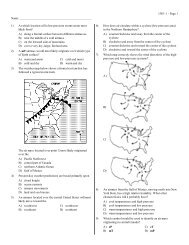
1242 - 1 - Page 50<strong>205</strong>) The weather map below shows a hurricane that was located over southern Florida. Theisobars show air pressure in inches of mercury. Letter A represents a point near the westcoast of Florida. The barogram shows the recorded air pressure in inches of mercury as thehurricane passed near Miami, Florida.What is the latitude and longitude at the center of the hurricane?A) 34DN 89DW B) 26DN 81DW C) 26DN 89DW D) 34DN 81DW