139736eo.pdf (20MB) - Japan Oceanographic Data Center
139736eo.pdf (20MB) - Japan Oceanographic Data Center
139736eo.pdf (20MB) - Japan Oceanographic Data Center
- No tags were found...
Create successful ePaper yourself
Turn your PDF publications into a flip-book with our unique Google optimized e-Paper software.
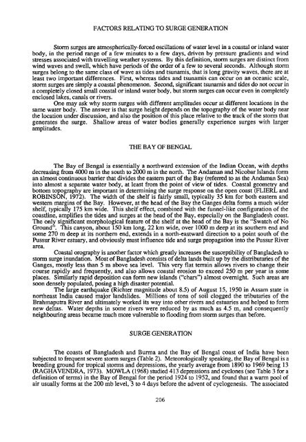
FACTORS RELATING TO SURGE GENERATIONStorm surges are atmospherically-forced oscillations of water level in a coastal or inland waterbody, in the period range of a few minutes to a few days, driven by pressure gradients and windstresses associated with travelling weather systems. By this definition, storm surges are distinct fromwind waves and swell, which have periods of the order of a few to several seconds. Although stormsurges belong to the same class of wave as tides and tsunamis, that is long gravity waves, there are atleast two important differences. First, whereas tides and tsunamis can occur on an oceanic scale,storm surges are simply a coastal phenomenon. Second, significant tsunamis and tides do not occur ina completely closed small coastal or inland water body, but storm surges can occur even in completelyenclosed lakes, canals or rivers.One may ask why storm surges with different amplitudes occur at different locations in thesame water body. The answer is that surge height depends on the topography of the water body nearthe location under discussion, and also the position of this place relative to the track of the stom thatgenerates the surge. Shallow areas of water bodies generally experience surges with largeramplitudes.THE BAY OF BENGALThe Bay of Bengal is essentially a northward extension of the Indian Ocean, with depthsdecreasing from 4000 m in the south to 2000 m in the north. The Andaman and Nicobar Islands forman almost continuous barrier that divides the eastern part of the Bay (referred to as the Andaman Sea)into almost a separate water body, at least from the point of view of tides. Coastal geometry andbottom topography are important in determining the surge response on the open coast (FLIERL andROBINSON, 1972). The width of the shelf is fairly small, typically 35 km for both eastern andwestern margins of the Bay. However, at the head of the Bay the Ganges delta forms a much widershelf, typically 175 km wide. This shelf effect, combined with the funnel-like configuration of thecoastline, amplifies the tides and surges at the head of the Bay, especially on the Bangladesh coast.The only significant morphological feature of the shelf at the head of the Bay is the “Swatch of NoGround”. This canyon, about 150 km long, 22 km wide, over 1000 m deep at its southern end andsome 270 m deep at its northern end, extends in a north-eastward direction to a point south of thePussur River estuary, and obviously must influence tide and surge propagation into the Pussur Riverarea.Coastal orography is another factor which greatly increases the susceptibility of Bangladesh tostorm surge inundation. Most of Bangladesh consists of delta lands built up by the distributaries of theGanges, mostly less than 5 m above sea level. This very flat terrain allows rivers to change theircourse rapidly and frequently, and also allows coastal erosion to exceed 250 m per year in someplaces. Similarly rapid deposition can form new islands (“chars”) almost overnight. Such areas aresoon densely populated, posing a high disaster potential.The large earthquake (Richter magnitude about 8.5) of August 15, 1950 in Assam state innortheast India caused major landslides. Millions of tons of soil clogged the tributaries of theBrahmaputra River and ultimately worked its way into other rivers and estuaries and helped to formnew deltas. Water depths in some rivers were reduced by as much as 4.5 my and consequentlyneighbouring areas became much more vulnerable to flooding from storm surges than before.SURGE GENERATIONThe coasts of Bangladesh and Burma and the Bay of Bengal coast of India have beensubjected to frequent severe storm surges (Table 2). Meteorologically speaking, the Bay of Bengal is abreeding ground for tropical storms and depressions, the yearly average from 1890 to 1969 being 13(RAGHAVENDRA, 1973). MOWLA (1968) studied 413 depressions and cyclones (see Table 3 for adefinition of terms) in the Bay of Bengal for the period 1924 to 1952, and found that a warm pool ofair usually forms at the 200 mb level, 3 to 4 days before the advent of cyclogenesis. The associated206


