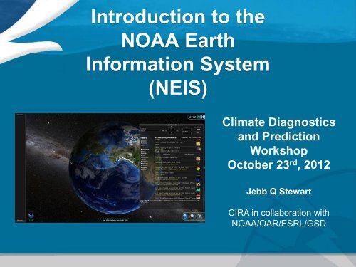
Introduction to the NOAA Earth Information System (NEIS) - Climate ...
Introduction to the NOAA Earth Information System (NEIS) - Climate ...
Introduction to the NOAA Earth Information System (NEIS) - Climate ...
- No tags were found...

You also want an ePaper? Increase the reach of your titles
YUMPU automatically turns print PDFs into web optimized ePapers that Google loves.
<strong>Introduction</strong> <strong>to</strong> <strong>the</strong><strong>NOAA</strong> <strong>Earth</strong><strong>Information</strong> <strong>System</strong>(NEIS)<strong>Climate</strong> Diagnosticsand PredictionWorkshopOc<strong>to</strong>ber 23 rd , 2012Jebb Q StewartCIRA in collaboration with<strong>NOAA</strong>/OAR/ESRL/GSD
ConceptTake advantage of existing technology where we can <strong>to</strong> quickly find andaccess <strong>to</strong> data 100 of years in <strong>the</strong> past <strong>to</strong> 100 years in <strong>the</strong> future, from <strong>the</strong><strong>to</strong>p of <strong>the</strong> atmosphere <strong>to</strong> <strong>the</strong> bot<strong>to</strong>m of <strong>the</strong> ocean in a single application.Framework provides capability <strong>to</strong> answer questions that require data fromdifferent data sources.
Data IntegrationChemicalPhysicalBiologicalFIMCarbonTrackerBiological, Chemical, and Physical data are all interrelated3
Improving <strong>the</strong> UserExperienceHow does industry make sense ofmassive amounts of information?• Applying existing concepts <strong>to</strong> <strong>NOAA</strong> data.
What is TerraViz?• 3D visualization <strong>to</strong>ol for <strong>Earth</strong>datasets developed inconjunction with NEIS• Developed in Unity, a popular3D game engine• Leverages <strong>the</strong> power of GPUs(graphical processing units). Forexample, TerraViz can load (andrender) 2.6 million polygonsfrom <strong>the</strong> FIM G9 global modeland performs quickly• Our source code is written in C# (a natively compiled language verysimilar <strong>to</strong> Java in syntax)
What is TerraViz?• Since we control <strong>the</strong> sourcecode, we can cus<strong>to</strong>mizeTerraViz however we wish andadd any feature we need• Develop once, <strong>the</strong>n will run onWindows, Mac, web browsers,iPhones, iPads, Androiddevices, and even gamesystems (Wii, Xbox 360, etc.)• Unity/C# development environment is designed for 3D development,making it easy <strong>to</strong> create multiple perspective views, create 3D meshesrepresenting environmental objects, etc.
NEISCORE ActivitiesNEIS team is looking at emerging technologies <strong>to</strong> discover and visualize data fromstandardized services, including OGC. Program can provide valuable feedback <strong>to</strong>system design from user perspective.Current Development Activities:o Exploring and evaluating ‘Cloud Technology’, currently NEIS backendservices are hosted on Amazon EC3 cloud.o Harvest metadata information from metadata reposi<strong>to</strong>ries (using OGC CSWstandard), and data access services.o Use Apache Solr <strong>to</strong> structure this information <strong>to</strong> create better searching anddiscovery functionality.o Building data access services <strong>to</strong> simplify requests for time sequences ofrendered data making <strong>the</strong>m available <strong>to</strong> NEIS/TerraViz.o Proxy and cache image requests <strong>to</strong> improve speed and reliability.
Dealing with DataData are ever increasing in size.• New Polar Orbiting NPP data (~ 4 TB / day)• GOES-R• New Global Forecast Models, rapidly increasing in size.• Vast amounts of his<strong>to</strong>rical data.We want <strong>to</strong>:• Provide <strong>to</strong>ols allowing seamless integration of data across timeand space.• Minimize data we transfer and avoid data duplication.• Allow users <strong>to</strong> collaborate with <strong>the</strong>se data.ESRL Global <strong>System</strong>s Division
Impacts• An infrastructure is available allowing users <strong>to</strong> discover, access, andintegrate relevant information regardless of data location and file format.• An visualization system is available <strong>to</strong> simultaneously compareensemble members, different models, with his<strong>to</strong>rical observations withina single platform.• <strong>NOAA</strong> data ready for action. Services model facilitates agile response <strong>to</strong>events. Services can be combined or reused quickly.• Any data available through NEIS system can be operated on orcombined with o<strong>the</strong>r data. Integrated standardized formats and access.• New and Existing systems have access <strong>to</strong> wide variety of <strong>NOAA</strong> data.Any new data added, easy incorporated with minimal <strong>to</strong> no changesrequired.ESRL Global <strong>System</strong>s Division
TerraViz Search ScreenGeographic extentDate / Time RangeKeywordsFacetsTerraViz can load local datasets or search <strong>the</strong> NEIS backend (> 1100 datasets)
TerraViz CollaborationAnnotation – Basic drawingcapabilities on <strong>to</strong>p of <strong>the</strong>globe (and any loadeddatasets)Multiuser/Collaboration –real time screen sharing withweb cams
TerraViz DatasetsGOCE gravimetry<strong>Earth</strong>quakesNORAD satellitesTerraViz can currently display•KML•FIM native grids•movies•images served up via web mapservers (e.g. NetCDF)FIM global wea<strong>the</strong>r model12
TerraViz Maps / TerrainProgressivedisclosure of terrain(as you zoom in yousee higher resolutionsatellite imagery)3D <strong>to</strong>pographyAbility <strong>to</strong> fly <strong>to</strong>locations on <strong>Earth</strong>13
TerraViz Multiple DatasetsTime wheelCan load multipledatasets over <strong>the</strong>globe and change<strong>the</strong> transparencybetween <strong>the</strong>mTime wheelshows when datais available foreach dataset andcan handledifferent timeintervals (e.g. onedataset could bedaily and ano<strong>the</strong>rmonthly)14TimeWheelDrag it up ordown <strong>to</strong>moveforward orbackwardthrough time
NEIS Committee andGroup InvolvementNEIS Team is aware and members of many related organizationsWe have active membership in a variety of committees and groups including:Open Geospatial Consortium (OGC) Standards Committees<strong>NOAA</strong> Environmental Data Management Committee (EDMC)<strong>NOAA</strong> Data Management Integration Team (DMIT)<strong>NOAA</strong> Unified Access Framework (UAF) groupNSF <strong>Earth</strong> CubeNextGen/CSS-Wx ProgramsFIM/WRF ModelingGIS Committee<strong>NOAA</strong> <strong>Climate</strong> Program Office (CPO) Data Interoperability TeamGSD Central Facility has vast experience in working with data and standardsESRL Global <strong>System</strong>s Division
Build new Graphical User Interface system integrating and leveragingnew and emerging technologies <strong>to</strong> meet NEIS goal ‘any data, anylocation, any platform, now’• Perform processing within cloud environment and with high speedconnectivity <strong>to</strong> data sources, taking advantage of large processingpower within clouds.• Send graphics and server side processed/rendered/streamed data <strong>to</strong>GUI, improving bandwidth utilization.• Take advantage of fast networking <strong>to</strong> make remote requests andprocessing appear like local application.• Similar <strong>to</strong> how <strong>the</strong> concept of <strong>the</strong> Amazon Silk Browser.Looking <strong>to</strong><strong>the</strong> FutureESRL Global <strong>System</strong>s Division
Improve existing Metadata services making information useful.• Improve searching by understanding what data means andproviding improved filtering capability similar <strong>to</strong> how airline or hoteltype search engines work.• Incentivize/encourage people <strong>to</strong> use proper Metadata.• Create a Metadata Dashboard <strong>to</strong>:o Ga<strong>the</strong>r information from users on relevance, ratings, usage patterns, searchkey words used (ie crowd sourcing).• This information can be used <strong>to</strong> determine what users are searching for,how <strong>the</strong>y are finding data, what data <strong>the</strong>y are not finding, etc...o Provide feedback on broken links, service uptimeo Provide feedback on adherence <strong>to</strong> standards (Services, Metadata).o Provide feedback <strong>to</strong> users of similar or related data sets.Looking <strong>to</strong> <strong>the</strong> FuturePart 2ESRL Global <strong>System</strong>s Division
Questions?Jebb.Q.Stewart@noaa.govhttp://www.esrl.noaa.gov/neis
Backup Slides
Why not Google <strong>Earth</strong>?• Handles ~10,000 kml polygons before slowing <strong>to</strong> a crawlWhy TerraViz andnot ano<strong>the</strong>r <strong>to</strong>ol?• Closed system (Google <strong>Earth</strong> source code not available) so we can’t add neededfeatures• Google <strong>Earth</strong> (web) plugin works on Windows and Mac 32-bit browsers only (won’t runon iPhones, iPads, or Android devices)Why not NASA WorldWind / iGlobe?• WorldWind (and iGlobe offshoot) is now open source (not sure how much NASA willcontinue <strong>to</strong> support it)• Requires Java (so it won’t run on iPhones, iPads, Android devices, etc.) and Javanumerics are significantly slower than TerraViz native numericsWhy not Integrated Data Viewer (IDV)?• Open source but is one million lines of code (a lot <strong>to</strong> learn) and original two developershave now left Unidata• Requires Java (so it won’t run on iPhones, iPads, Android devices, etc.) and Javanumerics are significantly slower than TerraViz native numerics• Very feature rich application, but current user interface is very complicated