1) Monte Cocusso 2) Monte Stena 3) Sentiero di fondovalle 4 ...
1) Monte Cocusso 2) Monte Stena 3) Sentiero di fondovalle 4 ...
1) Monte Cocusso 2) Monte Stena 3) Sentiero di fondovalle 4 ...

Create successful ePaper yourself
Turn your PDF publications into a flip-book with our unique Google optimized e-Paper software.
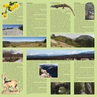
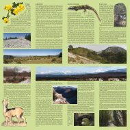
1) <strong>Monte</strong><br />
<strong>Cocusso</strong><br />
The path<br />
begins to<br />
u n w i n d<br />
from the small<br />
church de<strong>di</strong>cated<br />
to the Virgin Mary<br />
in Pesek. The Black Pine<br />
trees are gradually removing<br />
space to the Karstic moorland, a<br />
grass-covered steppe-like land that strongly<br />
marked the Karstic landscape in the past.<br />
The Downy Oaks that appear along the<br />
path are curved because of the strong wind<br />
called Bora that violently blows from East-<br />
North-East.<br />
After turning to the right you will see a mighty wild Linden<br />
with a circumference of 3.53 meters. A badger’s lair proves<br />
the presence of this plantigrade in this area.<br />
Before entering the European Hophornbeam woods the<br />
path runs along some typical Karstic furrowed fields.<br />
From the heap of stones on the top of the <strong>Cocusso</strong> Mountain<br />
the view opens up towards the Istria coastland, the Grado<br />
lagoon and the mountains far away.<br />
By turning slightly backwards you move on towards the<br />
Vertikala path where you can admire a large Common<br />
Beech (with a circumference of 2.73 meters) and some magnificent<br />
Turkey Oaks. In the nearby area are situated the<br />
highest caves of the Triestin Karst: the Pozzo della Miseria<br />
(602 m) and the Pozzo della Determinazione (610 m).<br />
Along the descent that leads to Grozzana you can see a<br />
number of ponds and the traces of some animals.<br />
Near every single pond there is a jazera, a<br />
deep round well, which was built for keeping<br />
ice. After visiting the quiet and sunny village<br />
of Grozzana the path ends alongside the<br />
meadowland Krasno polje, which is situated<br />
near the Goli Mountain.<br />
2) <strong>Monte</strong> <strong>Stena</strong><br />
After initially admiring the view over the Valley from<br />
the San Lorenzo vedetta, the path begins to unwind from<br />
the nearby church and the slope that dominates the valley.<br />
After running along a Downy Oak woods the path<br />
will bring you to the Black Pine woods, where during the<br />
various seasons of the year you can admire the Scorpion<br />
Senna, the Squarrose Knapweed, the Mountain Garlic, the<br />
Summer Savory and the Hyssop.<br />
The compact and inclined rocky layers of the <strong>Stena</strong><br />
Mountain are called reggipoggio as opposed to the franappoggio<br />
of the opposite slope (Carso Mountain), where<br />
the valley-oriented rocks cause the detachment of rocky<br />
material that constitutes the characteristic screes.<br />
Near the pine tree woods and under a magnificent St. Lucie’s<br />
Cherry there is the entrance of the San Lorenzo Cave.<br />
The panoramic view from this point reaches Sant’Antonio<br />
in Bosco, Moccò, Trieste, the San Michele Mountain,<br />
Bagnoli Superiore, Bagnoli della Rosandra and the Carso<br />
Mountain.<br />
In the period from May to June the marvellous and plentiful<br />
purple blossoms of the Thistle mark the end of the woods<br />
and the beginning of the Karstic moorland, an open<br />
space with Smoketree bushes that in autumn are coloured<br />
with warm tones of yellow, red and orange. Moreover, in<br />
this area there are young Black Pine trees, the advanceguards<br />
of an army which is slowly colonising the vulnerable<br />
moorland, where most of the endemic species grow.<br />
From the <strong>Stena</strong> Mountain slope you can see the waterfall,<br />
the Cippo Comici Memorial Stone, the small church of<br />
Santa Maria in Siaris, the Modugno Hut, the Carso Moutain,<br />
Bagnoli, the San Michele Moutain and Trieste. The<br />
view fly over bushes of Snowy Mespilus, which becomes<br />
whitish in springtime. The pines are like flags that wave<br />
in the Bora wind.<br />
The path begins to descent towards a wood of Black Pines,<br />
Flowering Ashes and Downy Oaks. The waterfall marks<br />
the point where the limestone separates itself from and<br />
the flysch. The limestone<br />
is covered with an<br />
explosion of blossoms<br />
that change their colour<br />
accor<strong>di</strong>ng to the season<br />
(yellow in springtime<br />
and violet-pink in autumn),<br />
whereas the vegetation<br />
on the flysch<br />
area is more compact<br />
and green.<br />
After reaching the bicycle<br />
path and turning<br />
left you can visit an interesting<br />
geological and<br />
historical site: on a rocky<br />
slope there are the ruins<br />
of the Draga Tabor, an<br />
old tower built in the 15th century. Near the trails of the<br />
old Trieste-Hrpelje railroad you can admire the traces of<br />
the drillings, that were carried out in 1885-1887.<br />
Under the calcareous walls that dominate the bicycle path<br />
up to the Modugno Hut you can admire some small-scale<br />
falls. In this area there are many interesting caves of historical<br />
and hydrogeological importance (the Grotta dei<br />
Pipistrelli, the Grotta delle Gallerie, the Grotta del Tasso,<br />
the Fessura del Vento, etc.).<br />
Nearby the Modugno Hut the path leaves the bicycle trail<br />
and ascents to a beautiful panoramic point: in late summer<br />
this area is completely covered by the Hyssop that<br />
melts its light blue and cerulean flowers with those of the<br />
Summer Savory which are white. The path ends in the<br />
Black Pine woods near San Lorenzo.<br />
3) <strong>Sentiero</strong> <strong>di</strong> <strong>fondovalle</strong><br />
T h i s<br />
path begins to unwind at the B a g n o l i<br />
Cave near Bagnoli della Ro- sandra and<br />
then it reaches Bagnoli Superiore and the Premuda<br />
Hut (where you can refresh yourselves) by running alongside<br />
the ruins of the Roman aqueduct from the 1st century<br />
AC.<br />
After leaving the “Water path” on the left, the path continues<br />
along the northern slopes of the <strong>Monte</strong> Carso. On this<br />
stretch of the path you can see the remains of the old watermills<br />
that in the past used the water of the torrent. The path<br />
runs over the “salt path” that was used by the merchants,<br />
who reached the salines of the city of Trieste.<br />
The paths rises and on the left there is the most important<br />
source of the Rosandra torrent, the Fonte Oppia. Here the<br />
vegetation is more thinned out and on the Altari slope you<br />
might see some rock-climbers. A little bit further up a narrow<br />
path leads to the Santa Maria in Siaris church and from<br />
here it continues to the Cippo Comici Memorial Stone, that<br />
was erected to commemorate the great climber, who <strong>di</strong>ed<br />
in 1940.<br />
The path runs mostly on screes, where some plants have<br />
adapted their roots to withstand the constant moving of the<br />
scree: the Prickly Drypis forms the characteristic stinging<br />
flowers that bloom from June to August.<br />
Some steps facilitate the short ascent that leads to a mar-<br />
vellous view of the waterfall and the small bridge under<br />
which run two watercourses: the Rio Grisa and the Rosandra<br />
torrent that flows from Bottazzo. Nearby there are the<br />
ruins of the Sancin watermill.<br />
Behind Bottazzo you can take the path<br />
no. 17 that leads to the bicycle path or<br />
refresh yourselves at the famous trattoria<br />
near the border. After reaching the<br />
Modugno Hut you can take the bicycle<br />
path that runs through two tunnels until<br />
it reaches a stone bridge and then it<br />
descents towards a European Hophornbeam<br />
and Downy Oak woods.<br />
Near the Moccò hill and the local vedetta<br />
you can see the remains of the<br />
Moccò Castle (Fünfenberg). By climbing<br />
a few steps you can then descent<br />
towards the San Michele mountain and<br />
before reaching the Premuda Hut you<br />
can admire various specimens of Flowering<br />
Ash, European Hophornbeam,<br />
Christ’s-thorn, St. Lucie’s Cherry, False Acacia, Coat Flower<br />
and Black Pine trees.<br />
4) <strong>Monte</strong> Carso<br />
The path that unwinds from<br />
the source Zgurenc in San<br />
Dorligo della Valle to the<br />
Carso Mountain is the most<br />
panoramic of the four path<br />
proposed. After ascen<strong>di</strong>ng<br />
among Black Pine trees, Flowering<br />
Ashes, Downy Oaks<br />
and Field Maples you reach<br />
the Moganjevec pond near<br />
the homonymous torrent.<br />
In the woods you might<br />
see some predatory<br />
birds such as the Buzzard<br />
and the Sparrow-Hawk<br />
or the more common Blackbird,<br />
Jay, Titmouse and Woodpecker.<br />
Behind the Downy Oaks woods there are the first specimens<br />
of the Aleppo Pine, which can be 15 meters high and<br />
1 meter wide.<br />
After passing the crossroad that leads to Crogole you reach<br />
the homonymous vedetta where the path begins to narrow<br />
and ascent more steeply. In this area you can see various<br />
flower such as the Primrose, the Hellebore, the Snowhite,<br />
the Iris, the Violet and the Scorpion Senna, which blossom<br />
in springtime, and the Chimney Bellflower, the Globe Thistle,<br />
the Summer Savory and the Cyclamen, which blossom<br />
in late summer.<br />
The panoramic view is marvellous: from here you can ad-<br />
mire the famous dolomitic mountains such as the Pelmo,<br />
Duranno and Antelao. On right there are the Tre Cime <strong>di</strong><br />
Lavaredo, which are more than 160 km away.<br />
After a short walk you can see the <strong>Monte</strong> Canin (which is<br />
90 km away) and gradually you will <strong>di</strong>scover the villages of<br />
Moccò, Sant’Antonio in Bosco, San Giuseppe della Chiusa,<br />
Bagnoli, Hervati, San Lorenzo, the Basovizza church and<br />
the Santuario <strong>di</strong> Monrupino. On the south you can see the<br />
<strong>Monte</strong> San Servolo, the cities of Koper and Pirano, the San<br />
Rocco hill and the city of Muggia.<br />
After walking alongside the Black Pine woods that cover<br />
most of the top of the Carso Mountain, you can turn left and<br />
reach the Grotta della Antiche Iscrizioni. If you continue on<br />
the slope of the Carso Mountain, where the Iris Illyrica, the<br />
Martagon Lily, the Snowhite and the Broom grow, you can<br />
reach the heap of stones that represent the ruins of the ancient<br />
Vallo del castelliere, the walls of the largest fortified<br />
village in the area of Trieste in the Bronze age. After descen<strong>di</strong>ng<br />
alongside some 100 years old Turkey Oaks (some<br />
of them are nearly 4 meters wide) you reach the vertical<br />
walls of the Crinale, which is used by rock-climbers, and<br />
finally reach the path at the bottom of the valley and the<br />
village of Bagnoli della Rosandra.
1) Pozzo della Determinazione – Brezno Determinazione - Determinazione Well; 2) Pozzo della Miseria – Brezno Miseria - Miseria Well; 3) Grotta <strong>di</strong> S.Lorenzo –<br />
Jama pri Jezeru - San Lorenzo’s Cave; 4) Grotta - jama Guido - Cave Guido; 5) Piccola Pocala – Jama na Štreki - Piccola Pocala Cave; 6) Grotta - jama degli Altari<br />
- Altari Cave; 7) Grotta del Montasio – Jama pod Kamenci - Montasio Cave; 8) Grotta – jama Fessura del Vento - Fessura del Vento Cave; 9) Grotta - jama della<br />
Sfesa - Sfesa Cave; 10) Pozzo presso la Grotta delle Gallerie – Brezno pri jami Pečina pod Steno - Grotta delle Gallerie Well; 11) Grotta delle Gallerie – Pečina pod<br />
Steno - Grotta delle Gallerie Cave; 12) Grotta delle Tacche – Jama s Stopničkami - Tacche Cave; 13) Grotta sopra i Molini <strong>di</strong> Bagnoli – Jama nad Gornjim Koncem -<br />
Cave above Bagnoli Superiore; 14) Grotta sulla sinistra del Torrente Rosandra – Jama v malem Supetu - Cave close to Mali Supet; 15) Grotta dei Pipistrelli – Jama<br />
netopirjev - Bat’s Cave; 16) Grotta - jama Gualtiero Savi - Gualtiero Savi Cave; 17) Grotta – jama sulla destra del Torrente Rosandra - Cave on the right-hand side of<br />
the Rosandra river; 18) Grotta – jama Martina - Martina Cave; 19) Grotta del Tasso – Pečina pri Rakniku - Tasso Cave; 20) Grotta – jama sul <strong>Monte</strong> Carso - <strong>Monte</strong><br />
Carso Cave; 21) Grotta delle Antiche Iscrizioni – Mejna jama - Ancient Inscriptions’ Cave; 22) Grotta – jama a Nord NordOvest del <strong>Monte</strong> Carso - Cave near the<br />
<strong>Monte</strong> Carso Mountain; 23) Grotta <strong>di</strong> Crogole – Krogljanska jama - Crogole’s Cave; 24) Caverna degli Orsi – Medvedja jama - Bears’ Cave.<br />
Sorgenti/Izviri/Sources<br />
Vertikala<br />
Stagni, laghetti, vasche/Mlake, jezerca, korita/ Ponds and small lakes<br />
Confine della Riserva/Meje Rezervata/ Reserve’s borders<br />
“Immagini TerraitalyTM” - © Compagnia Generale Ripreseaeree S.p.A. - Parma www.terraitaly.it - Pictures and graphics: Dario Gasparo - Texts: Elio Polli and Dario Gasparo<br />
The Regional Nature Reserve of the Val Rosandra Valley was<br />
founded in 1996 and it stretches over an area of approximately 746<br />
hectares. In 2006 an agreement with the Friuli Venezia Giulia Regional<br />
Government was signed accor<strong>di</strong>ng to which the Municipality<br />
of Dolina became the Managing Authority of the Reserve.<br />
The Reserve is situated in the south-eastern part of the Province of<br />
Trieste, along the border with the Slovenian Municipality of Hrpelje-Kozina,<br />
where the torrent Rosandra has its source. Its canyon<br />
dug into limestone attracts groups of nature lovers, speleologists<br />
and climbers. Along the paths that wind across the Illyric, Me<strong>di</strong>terranean<br />
and alpine vegetation, visitors can <strong>di</strong>scover numerous<br />
caves of historical, naturalistic and speleological interest. From various<br />
observation points they can enjoy marvellous views of the<br />
Gulf of Trieste and the Alps. The basins and small waterfalls of<br />
the Rosandra torrent forebode the spectacular 36-meters-high waterfall<br />
which sometimes completely freezes in winter. These places<br />
are permeated by a rich history, which is proven by the small<br />
church of Santa Maria in Siaris, the ruins of the Roman aqueduct,<br />
the ancient watermills and the Moccò Castle.<br />
The Val Rosandra Valley is crossed by many paths marked by CAI,<br />
the Italian Alpine Club, and the Slovenian Alpine Association of<br />
Trieste. In the following pages you will be introduced to four paths<br />
that cross the Reserve and are open throughout the year.<br />
Managing Authority: Municipality of Dolina<br />
Address: Dolina 270 - 34018 San Dorligo della Valle (TS)<br />
Telefone no.: +39 040 8329237<br />
Reserve’s visiting centre: Bagnoli della Rosandra-Boljunec 507<br />
Telefone no.: +39 040 8326435<br />
Internet: www.riservavalrosandra-glinscica.it<br />
Extent: 746 ha<br />
Texts: Dario Gasparo and Elio Polli. Photography: Dario Gasparo. Translation: Peter Senizza<br />
Regional Nature Reserve of<br />
the Val Rosandra