ROSE RUN GREENWAY CORRIDOR - New Albany, Ohio
ROSE RUN GREENWAY CORRIDOR - New Albany, Ohio ROSE RUN GREENWAY CORRIDOR - New Albany, Ohio
B. HydrologyFigure 6 - Current Hydrological Points of Pressure.page 10The Rose Run corridor served as the historical backbone of development inthe original village. Early businesses located along the Rose Run to takeadvantage of the water source and the power that it could provide. Behindthe Ealy House, a dam was built to capture power used for logging the siteand operating the shallow stone quarry. At the center of the Village, numerousstructures emerged over the early decades, taking advantage of the corridorand access to the main thoroughfare through the area. This was Dublin-Granville Road, which evolved along this corridor, becoming the primaryeast-west route through northern Franklin County.The result of this development pattern was a general modification to thestream corridor that took place over time. These modifications were invariablyalterations away from the natural course and nature of the stream in favorof the built environment. These impacts are felt throughout the corridorincluding the Ealy House dam and the intersection bridge at Market Street.The impacts are most strongly evidenced near the Dublin-Granville / MainStreet intersection where structures have been sited practically in the streamcorridor. These pressure points are indicated in the above diagram by yellowarrows. While generalized, these arrows illustrate the repeated points atwhich the stream corridor has been impacted for the worse of the course ofthe Village's history.The result of these changes are clear. The stream banks have been modifiedwith fill, concrete walls have been constructed, and concrete "rip-rap" hasbeen used to divert the natural stream course. The result is serious fromboth an overall environmental viewpoint and a short-term practical one.Environmentally, the natural stream corridor does not function property due toportions of misaligned streambed, lost vegetation, and stream channelization.The cumulative impact of these pressures has been a serious decline in theoverall stream quality.Flooding impacts on the Rose Run Corridor, May 15, 2003 - photo of the Main Street / Dublin-Granville Intersection looking northwest.Remnants of the old mill dam behind the Ealy House. End of culvert from north tributary to Rose Run. Channelized Rose Run stream east of Main Street.
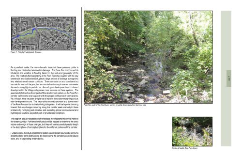
Figure 7 - Potential Hydrological Changes.As a practical matter, the more dramatic impact of these pressure points isflooding and diminished stormwater drainage. The Rose Run corridor and itstributaries are sensitive to flooding based on the soils and geography of thearea. The relatively flat topography of the Plain Township coupled with the claybased soils and shallow bedrock, place a large amount of drainage acreage intofew, relatively small stream corridors. There corridors run at a consistent butlow rate for much of the year, but are counted on to carry immense stormwaterdemands during high impact storms. As such, past development and continueddevelopment in the Village only places more pressure on these systems. Theassociated photos show the impacts of this development pattern, as the Rose Runcorridor can become over-capacity with the proper confluence of storm events.As a Village, there has been a vigilance to improve these stormwater impacts asnew development occurs. This has mainly occurred upstream and downstreamof the Rose Run corridor in the hydrological system. It will be important movingforward that any changes occurring along this corridor seek a remedy to theseproblems by rectifying past mistakes and recreating proper environmental andhydrological solutions as part of park or private redevelopment.Rose Run south of the Ealy House - portion of quality stream away from dammed areapage 11The diagram above indicates basic hydrological modifications that would improvethe stream corridor. Further scientific study will be needed to determine the exactnature and design of these changes, but they will be discussed at greater lengthin the descriptions of conceptual plans for the different portions of the corridor.Fundamentally, this study proposes to restore natural stream courses by removingstreambed and bank obstructions, de-channelizing the corridor back to its naturalstate, and re-vegetating stream banks.Portion of quality Rose Run stream
- Page 1: ROSE RUN GREENWAY CORRIDORNew Alban
- Page 4 and 5: Planning ProcessThe plan was create
- Page 7 and 8: I. Introduction
- Page 9 and 10: Dublin-Granville RoadHigh StreetDub
- Page 11: Southwest elevation of the 1860 eal
- Page 14 and 15: Before exploring the opportunities
- Page 18 and 19: C. Pedestrian CirculationFigure 8 -
- Page 21: III. PlanElements
- Page 24 and 25: Rose Run II - Concept AThe primary
- Page 26 and 27: Rose Run II - Concept BThe solution
- Page 28 and 29: B. market street/dublin-granvillero
- Page 30 and 31: B. Village Center SouthVillage Cent
- Page 32 and 33: E. Founders ParkFounders Park is th
- Page 34 and 35: page 28Figure 20 - Rose Run Corrido
- Page 37 and 38: IV. Prioritization& Cost
- Page 39: General Cost Estimate*Rose Run IIEs
- Page 42 and 43: Implementation StrategiesIn order t
Figure 7 - Potential Hydrological Changes.As a practical matter, the more dramatic impact of these pressure points isflooding and diminished stormwater drainage. The Rose Run corridor and itstributaries are sensitive to flooding based on the soils and geography of thearea. The relatively flat topography of the Plain Township coupled with the claybased soils and shallow bedrock, place a large amount of drainage acreage intofew, relatively small stream corridors. There corridors run at a consistent butlow rate for much of the year, but are counted on to carry immense stormwaterdemands during high impact storms. As such, past development and continueddevelopment in the Village only places more pressure on these systems. Theassociated photos show the impacts of this development pattern, as the Rose Runcorridor can become over-capacity with the proper confluence of storm events.As a Village, there has been a vigilance to improve these stormwater impacts asnew development occurs. This has mainly occurred upstream and downstreamof the Rose Run corridor in the hydrological system. It will be important movingforward that any changes occurring along this corridor seek a remedy to theseproblems by rectifying past mistakes and recreating proper environmental andhydrological solutions as part of park or private redevelopment.Rose Run south of the Ealy House - portion of quality stream away from dammed areapage 11The diagram above indicates basic hydrological modifications that would improvethe stream corridor. Further scientific study will be needed to determine the exactnature and design of these changes, but they will be discussed at greater lengthin the descriptions of conceptual plans for the different portions of the corridor.Fundamentally, this study proposes to restore natural stream courses by removingstreambed and bank obstructions, de-channelizing the corridor back to its naturalstate, and re-vegetating stream banks.Portion of quality Rose Run stream


