Manual on sea level measurement and ... - unesdoc - Unesco
Manual on sea level measurement and ... - unesdoc - Unesco Manual on sea level measurement and ... - unesdoc - Unesco
Sea Level Measurement and InterpretationConclusionsAll the sea level sensors installed at Vilagarcía havebeen shown to be accurate enough for such standardapplications as tide, storm surges, and even mean sealevel, although the latter would need more study, tobe completely sure. However, differences were foundin the higher frequency range, which we have decidedto continue to study. The reason for this is our interest,and may be that of the rest of the sea level community,to detect seiches and tsunamis and even include thesensors in an alert system. Concerning this, the sensorswith a lower sampling frequency of the raw datashould demonstrate that they are not measuring justnoise, but also other physical signals.Concerning the radar sensors, a very important conclusionis that they have shown that they are very easyto install and require almost no maintenance, which isvery important for equipment for permanent networks.Nearly no incident occurred during the two years oftesting, especially with the Miros and Geónica sensors;only the Seba sensor was an exception. Nevertheless,care has to be taken when stating something like this,because, sometimes, a lack of information on the sensorconfiguration and installation requirements may bejust the explanation for some of the failures.More detailed description of the experiment and discussionof the data can be found in ESEAS-RI (2005)and Martín et al. (2005).ReferencesESEAS-RI. (2005) Assessment of accuracy and operationalproperties of different tide gauge sensors.WP4 Deliverable D4.1, Technical Report. (http://www.eseas.org)Martín, B., Pérez, B., Alvarez Fanjul, E. 2005. TheESEAS-RI sea level test station: reliability and accuracyof different tide gauges. International HydrographicReview, 6, 44-53.Pérez, B. and López Maldonado, J.D. 2003. Experiencewith Sonar Research and Development (SRD) acousticgauges in Spain. IOC Workshop Report 193Woodworth P.L. and Smith D.E. 2003. A one-yearcomparison of radar and bubbler tide gauges atLiverpool. International Hydrographic Review, 4,2-9.64IOC
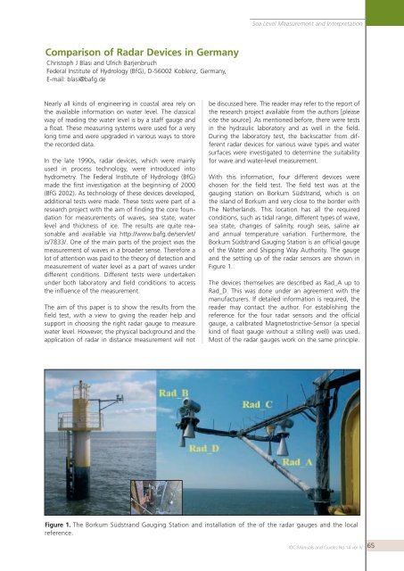
Sea Level Measurement and InterpretationComparison of Radar Devices in GermanyChristoph J Blasi and Ulrich BarjenbruchFederal Institute of Hydrology (BfG), D-56002 Koblenz, Germany,E-mail: blasi@bafg.deNearly all kinds of engineering in coastal area rely onthe available information on water level. The classicalway of reading the water level is by a staff gauge anda float. These measuring systems were used for a verylong time and were upgraded in various ways to storethe recorded data.In the late 1990s, radar devices, which were mainlyused in process technology, were introduced intohydrometry. The Federal Institute of Hydrology (BfG)made the first investigation at the beginning of 2000(BfG 2002). As technology of these devices developed,additional tests were made. These tests were part of aresearch project with the aim of finding the core foundationfor measurements of waves, sea state, waterlevel and thickness of ice. The results are quite reasonableand available via http://www.bafg.de/servlet/is/7833/. One of the main parts of the project was themeasurement of waves in a broader sense. Therefore alot of attention was paid to the theory of detection andmeasurement of water level as a part of waves underdifferent conditions. Different tests were undertakenunder both laboratory and field conditions to accessthe influence of the measurement.The aim of this paper is to show the results from thefield test, with a view to giving the reader help andsupport in choosing the right radar gauge to measurewater level. However, the physical background and theapplication of radar in distance measurement will notbe discussed here. The reader may refer to the report ofthe research project available from the authors [pleasecite the source]. As mentioned before, there were testsin the hydraulic laboratory and as well in the field.During the laboratory test, the backscatter from differentradar devices for various wave types and watersurfaces were investigated to determine the suitabilityfor wave and water-level measurement.With this information, four different devices werechosen for the field test. The field test was at thegauging station on Borkum Südstrand, which is onthe island of Borkum and very close to the border withThe Netherlands. This location has all the requiredconditions, such as tidal range, different types of wave,sea state, changes of salinity, rough seas, saline airand annual temperature variation. Furthermore, theBorkum Südstrand Gauging Station is an official gaugeof the Water and Shipping Way Authority. The gaugeand the setting up of the radar sensors are shown inFigure 1.The devices themselves are described as Rad_A up toRad_D. This was done under an agreement with themanufacturers. If detailed information is required, thereader may contact the author. For establishing thereference for the four radar sensors and the officialgauge, a calibrated Magnetostrictive-Sensor (a specialkind of float gauge without a stilling well) was used.Most of the radar gauges work on the same principle.Figure 1. The Borkum Südstrand Gauging Station and installation of the of the radar gauges and the localreference.IOC
- Page 20 and 21: Sea Level Measurement and Interpret
- Page 22 and 23: Sea Level Measurement and Interpret
- Page 24 and 25: Sea Level Measurement and Interpret
- Page 26 and 27: Sea Level Measurement and Interpret
- Page 30 and 31: Sea Level Measurement and Interpret
- Page 32 and 33: Sea Level Measurement and Interpret
- Page 34 and 35: Sea Level Measurement and Interpret
- Page 36 and 37: Sea Level Measurement and Interpret
- Page 38 and 39: Sea Level Measurement and Interpret
- Page 40 and 41: Sea Level Measurement and Interpret
- Page 42 and 43: Sea Level Measurement and Interpret
- Page 44 and 45: Sea Level Measurement and Interpret
- Page 46 and 47: Sea Level Measurement and Interpret
- Page 48 and 49: Sea Level Measurement and Interpret
- Page 50 and 51: Sea Level Measurement and Interpret
- Page 52 and 53: Sea Level Measurement and Interpret
- Page 54 and 55: Sea Level Measurement and Interpret
- Page 56 and 57: Sea Level Measurement and Interpret
- Page 58 and 59: Sea Level Measurement and Interpret
- Page 60 and 61: Sea Level Measurement and Interpret
- Page 62 and 63: Sea Level Measurement and Interpret
- Page 64 and 65: Sea Level Measurement and Interpret
- Page 66 and 67: Sea Level Measurement and Interpret
- Page 68 and 69: Sea Level Measurement and Interpret
- Page 72 and 73: Sea Level Measurement and Interpret
- Page 74 and 75: Sea Level Measurement and Interpret
- Page 76 and 77: Sea Level Measurement and Interpret
- Page 78 and 79: Sea Level Measurement and Interpret
- Page 80 and 81: Sea Level Measurement and Interpret
- Page 82 and 83: Sea Level Measurement and Interpret
- Page 84 and 85: Sea Level Measurement and Interpret
- Page 86: Sea Level Measurement and Interpret
Sea Level Measurement <strong>and</strong> Interpretati<strong>on</strong>Comparis<strong>on</strong> of Radar Devices in GermanyChristoph J Blasi <strong>and</strong> Ulrich BarjenbruchFederal Institute of Hydrology (BfG), D-56002 Koblenz, Germany,E-mail: blasi@bafg.deNearly all kinds of engineering in coastal area rely <strong>on</strong>the available informati<strong>on</strong> <strong>on</strong> water <strong>level</strong>. The classicalway of reading the water <strong>level</strong> is by a staff gauge <strong>and</strong>a float. These measuring systems were used for a veryl<strong>on</strong>g time <strong>and</strong> were upgraded in various ways to storethe recorded data.In the late 1990s, radar devices, which were mainlyused in process technology, were introduced intohydrometry. The Federal Institute of Hydrology (BfG)made the first investigati<strong>on</strong> at the beginning of 2000(BfG 2002). As technology of these devices developed,additi<strong>on</strong>al tests were made. These tests were part of are<strong>sea</strong>rch project with the aim of finding the core foundati<strong>on</strong>for <strong>measurement</strong>s of waves, <strong>sea</strong> state, water<strong>level</strong> <strong>and</strong> thickness of ice. The results are quite reas<strong>on</strong>able<strong>and</strong> available via http://www.bafg.de/servlet/is/7833/. One of the main parts of the project was the<strong>measurement</strong> of waves in a broader sense. Therefore alot of attenti<strong>on</strong> was paid to the theory of detecti<strong>on</strong> <strong>and</strong><strong>measurement</strong> of water <strong>level</strong> as a part of waves underdifferent c<strong>on</strong>diti<strong>on</strong>s. Different tests were undertakenunder both laboratory <strong>and</strong> field c<strong>on</strong>diti<strong>on</strong>s to accessthe influence of the <strong>measurement</strong>.The aim of this paper is to show the results from thefield test, with a view to giving the reader help <strong>and</strong>support in choosing the right radar gauge to measurewater <strong>level</strong>. However, the physical background <strong>and</strong> theapplicati<strong>on</strong> of radar in distance <strong>measurement</strong> will notbe discussed here. The reader may refer to the report ofthe re<strong>sea</strong>rch project available from the authors [pleasecite the source]. As menti<strong>on</strong>ed before, there were testsin the hydraulic laboratory <strong>and</strong> as well in the field.During the laboratory test, the backscatter from differentradar devices for various wave types <strong>and</strong> watersurfaces were investigated to determine the suitabilityfor wave <strong>and</strong> water-<strong>level</strong> <strong>measurement</strong>.With this informati<strong>on</strong>, four different devices werechosen for the field test. The field test was at thegauging stati<strong>on</strong> <strong>on</strong> Borkum Südstr<strong>and</strong>, which is <strong>on</strong>the isl<strong>and</strong> of Borkum <strong>and</strong> very close to the border withThe Netherl<strong>and</strong>s. This locati<strong>on</strong> has all the requiredc<strong>on</strong>diti<strong>on</strong>s, such as tidal range, different types of wave,<strong>sea</strong> state, changes of salinity, rough <strong>sea</strong>s, saline air<strong>and</strong> annual temperature variati<strong>on</strong>. Furthermore, theBorkum Südstr<strong>and</strong> Gauging Stati<strong>on</strong> is an official gaugeof the Water <strong>and</strong> Shipping Way Authority. The gauge<strong>and</strong> the setting up of the radar sensors are shown inFigure 1.The devices themselves are described as Rad_A up toRad_D. This was d<strong>on</strong>e under an agreement with themanufacturers. If detailed informati<strong>on</strong> is required, thereader may c<strong>on</strong>tact the author. For establishing thereference for the four radar sensors <strong>and</strong> the officialgauge, a calibrated Magnetostrictive-Sensor (a specialkind of float gauge without a stilling well) was used.Most of the radar gauges work <strong>on</strong> the same principle.Figure 1. The Borkum Südstr<strong>and</strong> Gauging Stati<strong>on</strong> <strong>and</strong> installati<strong>on</strong> of the of the radar gauges <strong>and</strong> the localreference.IOC <str<strong>on</strong>g>Manual</str<strong>on</strong>g>s <strong>and</strong> Guides No 14 vol IV65


