Sea Level Measurement <strong>and</strong> Interpretati<strong>on</strong>or more stati<strong>on</strong>s. Levelling c<strong>on</strong>necti<strong>on</strong>s within thesenetworks then allow the heights of objects (e.g. mountains)to be related to MSL at the coast. For example,the UK nati<strong>on</strong>al <strong>level</strong>ling network expresses heights interms of ‘Ordnance Datum Newlyn’ (ODN), which wasthe average <strong>level</strong> of the <strong>sea</strong> at Newlyn in southwestEngl<strong>and</strong> during 1915–21. ODN can be thought of as animaginary datum plane extending over a large area (i.e.over the whole of Great Britain). The heights of benchmarks, for example, can be expressed in terms of ODNas can, therefore, the Chart Datum at the port.The c<strong>on</strong>cept of a nati<strong>on</strong>al <strong>level</strong>ling network has underg<strong>on</strong>erevoluti<strong>on</strong>ary change during the last decade, primarilydue to the advent of GPS. However, it was alreadya defective c<strong>on</strong>cept from the point of view of <strong>sea</strong> <strong>level</strong>studies, for several reas<strong>on</strong>s. First, <strong>sea</strong> <strong>level</strong> has risen atNewlyn since 1915, as it has d<strong>on</strong>e at many other placesaround the world, so ODN no l<strong>on</strong>ger represents thepresent average Newlyn <strong>level</strong>s. Sec<strong>on</strong>d, the mean <strong>sea</strong>surface around a coast is not ‘flat’, i.e. it does not followthe geoid, but varies due to ocean currents, density differences,meteorological effects etc. C<strong>on</strong>sequently, MSLwas never a perfect choice for a nati<strong>on</strong>al datum plane.Third, rates of change of MSL are different at differentlocati<strong>on</strong>s, thereby complicating the time-dependenceof the network. Fourth, all nati<strong>on</strong>al <strong>level</strong>ling networks(with the possible excepti<strong>on</strong> of that of The Netherl<strong>and</strong>s,Finl<strong>and</strong> <strong>and</strong> Sweden) c<strong>on</strong>tain multi-decimetric errors dueto systematic, instrumental errors in the <strong>level</strong>ling. Fifth,as <strong>level</strong>ling networks tended to be redefined at intervals,their redefiniti<strong>on</strong> in itself was a potential source of error,as ‘heights’ were redefined.C<strong>on</strong>sequently, while interacti<strong>on</strong> between <strong>sea</strong> <strong>level</strong> specialists<strong>and</strong> nati<strong>on</strong>al surveyors is inevitable, we advisemost <strong>sea</strong> <strong>level</strong> specialists to take great care with thec<strong>on</strong>cept of a nati<strong>on</strong>al <strong>level</strong>ling system.4.1.7 Chart DatumThe chart datum (or Admiralty Chart Datum in the UK)is the low-water plane below which the depths <strong>on</strong> anautical chart are measured <strong>and</strong> above which, tidal <strong>level</strong>sare often presented for practical purposes, such astide tables for harbour operati<strong>on</strong>s. The chart datum isa horiz<strong>on</strong>tal plane over a limited area <strong>and</strong> the elevati<strong>on</strong>of this plane will vary around the coastline, depending<strong>on</strong> the tidal ranges at the places c<strong>on</strong>sidered. In theUK, the chart datum at a port is the same as ‘LowestAstr<strong>on</strong>omical Tide’ (Pugh, 1987).4.1.8 Working DatumsPractical working datums are often used in portswhere they describe <strong>sea</strong> <strong>level</strong> (or water depth) moreclearly than perhaps a scientifically rigorous referenceto a benchmark. Examples of such datums includethe <strong>level</strong>s of the sill of a lock or a shallow point in theentrance to a harbour. The <strong>sea</strong> <strong>level</strong> from a tide gaugethen indicates the depth of water above these hazards.Working datums often functi<strong>on</strong>ed as the first TGBMsfor Europe’s <strong>sea</strong> <strong>level</strong> records (e.g. the ‘Old Dock Sill’datum at Liverpool).4.2 Levelling Between LocalBenchmarksHigh-precisi<strong>on</strong> <strong>level</strong>ling will need to be made betweenall the marks of the local network at regular intervals.For GLOSS purposes, the recommendati<strong>on</strong> is that theexercise be repeated at least annually, with results fullydocumented by the resp<strong>on</strong>sible agency. The exact frequencyof required <strong>level</strong>ling will depend <strong>on</strong> the geologyof the area. On unstable ground, more frequent <strong>level</strong>lingmay be necessary.Pers<strong>on</strong>nel familiar with the best practices of the techniqueshould perform <strong>level</strong>ling with a good-quality <strong>level</strong><strong>and</strong> staff. For example, if marks are far apart, it will benecessary to establish ‘staging points’ clearly identified<strong>and</strong> about 50 m apart <strong>on</strong> a hard surface. This can bed<strong>on</strong>e by painting a small ring around the point <strong>and</strong>,<strong>on</strong> softer surfaces, by driving in a round-headed pin.The <strong>level</strong>ling instrument can then be set up between abenchmark <strong>and</strong> the first staging point <strong>and</strong> readings ofthe staff taken at the two positi<strong>on</strong>s. This is then repeatedthroughout the whole network. It is important thatthe pairs of readings be taken in the correct sequence,otherwise an err<strong>on</strong>eous height difference will result.Modern <strong>level</strong>ling instruments with built-in data loggerscan remove most of the tedious arithmetic associatedwith the use of a simple <strong>level</strong>.As with many other aspects of tide gauge operati<strong>on</strong>s,the main principle of <strong>level</strong>ling is that ‘practice makesperfect’. For advice <strong>on</strong> good <strong>level</strong>ling methods, thePSMSL website (www.pol.ac.uk/psmsl) c<strong>on</strong>tains a set ofnotes used by Prof. Charles Merry at the University ofCape Town GLOSS Training Course in 1998.4.3 Levelling Between Wider AreaMarksThe height of the TGBM should also be related to awider area network extending typically 10 km. Thisprovides a verificati<strong>on</strong> of whether the <strong>sea</strong> <strong>level</strong> measuredrelative to the TGBM is c<strong>on</strong>sistent with that ofthe surrounding area.First-order geodetic <strong>level</strong>ling is accurate to 1 or 2 mmover distances of a few kilometres <strong>and</strong>, therefore,annual campaigns can detect any vertical movementsof the TGBM with respect to the local benchmarks.30IOC <str<strong>on</strong>g>Manual</str<strong>on</strong>g>s <strong>and</strong> Guides No 14 vol IV
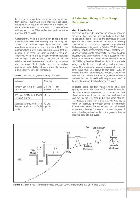
Sea Level Measurement <strong>and</strong> Interpretati<strong>on</strong>Levelling over l<strong>on</strong>ger distances has been found to c<strong>on</strong>tainsignificant systematic errors that can cause apparentspurious changes in the height of the TGBM. Forthis reas<strong>on</strong> the PSMSL requires MSL data to be definedwith respect to the TGBM rather than with respect t<strong>on</strong>ati<strong>on</strong>al datum <strong>level</strong>s.C<strong>on</strong>sequently, while it is desirable in principle to performregular wide area <strong>level</strong>ling, their accuracy hasalways to be c<strong>on</strong>sidered, especially as the areas c<strong>on</strong>sideredbecome wider. At a distance of some 10 km, theerrors involved in <strong>level</strong>ling become comparable to tho<strong>sea</strong>chievable by means of space geodetic techniques.Therefore, while the choice of technology for the widerarea surveys is clearly evolving, the principle that therelative <strong>sea</strong> <strong>level</strong> <strong>measurement</strong>s provided by the gaugedata are applicable to studies for the surroundingarea is still valid. Table 4.1 summarizes the accuracyobtained by the different techniques.Table 4.1 Accuracy of geodetic fixing of TGBMs.TechniqueAccuracy4.4 Geodetic Fixing of Tide GaugeBenchmarks4.4.1 Introducti<strong>on</strong>Over the past decade, advances in modern geodetictechniques have provided new methods for fixing tidegauge bench marks. These are the techniques of spacegeodesy, using the satellites of the Global Positi<strong>on</strong>ingSystem (GPS) <strong>and</strong> those of the Doppler Orbitography <strong>and</strong>Radiopositi<strong>on</strong>ing Integrated by Satellite (DORIS) system.Absolute gravity <strong>measurement</strong>s provide collateral evidenceof vertical crustal movements. The space geodesy<strong>measurement</strong>s can be used to fix into a geocentric referenceframe the GPSBM, which should be c<strong>on</strong>nected tothe TGBM by <strong>level</strong>ling. Therefore, the MSL at the tidegauge can be defined in a global geocentric referenceframe. This furnishes an absolute measure of mean <strong>sea</strong><strong>level</strong>, rather than MSL relative to each local TGBM, oreven to the wider surrounding area. Measurements of <strong>sea</strong><strong>level</strong> are then defined in the same geocentric referenceframe as that used for satellite altimetry <strong>and</strong> can thereforebe directly compared with altimetric <strong>sea</strong> <strong>level</strong>s.Primary Levelling of LocalBenchmarksGPS from TGBM to SLR/VLBIReference FrameAbsolute Gravity near TideGauges <strong>and</strong> at SLR/VLBIStati<strong>on</strong>0–1 km: