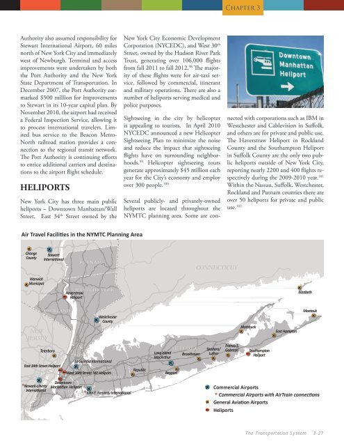
<strong>Chapter</strong> 3Authority also assumed responsibility forStewart International Airport, 60 milesnorth of <strong>New</strong> <strong>York</strong> City and immediatelywest of <strong>New</strong>burgh. Terminal and accessimprovements were undertaken by boththe Port Authority and the <strong>New</strong> <strong>York</strong>State Department of <strong>Transportation</strong>. InDecember 2007, the Port Authority earmarked$500 million for improvementsto Stewart in its 10-year capital plan. ByNovember 2010, the airport had receiveda Federal Inspection Service, allowing itto process international travelers. Limitedbus service to the Beacon Metro-North railroad station provides a connectionto the regional transit network.<strong>The</strong> Port Authority is continuing effortsto entice additional carriers and destinationsto the airport flight schedule.HELIPORTS<strong>New</strong> <strong>York</strong> City has three main publicheliports – Downtown Manhattan/WallStreet, East 34 th Street owned by the<strong>New</strong> <strong>York</strong> City Economic DevelopmentCorporation (NYCEDC), and West 30 thStreet, owned by the Hudson River ParkTrust, generating over 106,000 flightsfrom fall 2011 to fall 2012. 98 <strong>The</strong> majorityof these flights were for air-taxi service,followed by commercial, itinerantand military operations. <strong>The</strong>re are also anumber of heliports serving medical andpolice purposes.Sightseeing in the city by helicopteris appealing to tourists. In April 2010NYCEDC announced a new HelicopterSightseeing Plan to minimize the noiseand reduce the impact that sightseeingflights have on surrounding neighborhoods.99 Helicopter sightseeing toursgenerate approximately $45 million eachyear for the City’s economy and employover 300 people. 100Several publicly- and privately-ownedheliports are located throughout theNYMTC planning area. Some are connectedwith corporations such as IBM inWestchester and Cablevision in Suffolk,and others are for private and public use.<strong>The</strong> Haverstraw Heliport in RocklandCounty and the Southampton Heliportin Suffolk County are the only two publicheliports outside of <strong>New</strong> <strong>York</strong> City,reporting nearly 2200 and 400 flights respectivelyduring the 2009-2010 year. 101Within the Nassau, Suffolk, Westchester,Rockland and Putnam counties there areover 50 heliports for private and publicuse. 102Air Travel Facilities in in the NYMTC Planning Region Areae !e !OrangeCountye !e !StewartInternationalPUTNAMCONNECTICUTe !WarwickMunicipalWESTCHESTERHaverstraw!f HeliportElizabethe !NEWJERSEYe !ROCKLANDe !e !e !e !WestchesterCountyFrancis S.S U F F O L KTeterboroSpadaro/ GabreskiLong IslandSouthamptonBRONXBrookhaven Lufker!fMac ArthurHeliportLa Guardia InternationalEast 34th Street Heliport!f fRepublic! West 30th Street VIP HeliportBayport!f QUEENSNASSAUDowntown-* <strong>New</strong>ark-Liberty Manhattan Heliport ! Commercial AirportsInternational KINGS* John F. Kennedy International* Commercial Airports with AirTrain connectionsSTATENIS.General Aviation Airports!f Heliportse !e !e !e !ee !e !e !Mattitucke !e !East HamptonMontauke !<strong>The</strong> <strong>Transportation</strong> <strong>System</strong> 3-27
<strong>Chapter</strong> 3In July of 2012 the City of Long Beachkicked-off a bicycle share program withthe opening of at least 16 kiosks with400 bicycles that can be rented. <strong>The</strong>re isan estimated 47 miles of sidewalks alongstate roads in Nassau County and 188miles of sidewalks along state roads inSuffolk County. This does not includesidewalks along local roads and streets.Lower Hudson ValleyBike share station in Lower ManhattanWalking and bicycling are among themost sustainable forms of transportation,providing residents in the area withthe means for commuting and recreation.Nearly half of the commuters inthe NYMTC planning area rely on walkingor bicycling as a means of travel towork, in whole or in part.USER VOLUMESAccording to 2010 U.S. Census, theNYMTC planning area has a total populationof 12,368,525 residents, an increaseof 2.5 percent from 2000; withthe total number of workers increasingby 8.6 percent. Table 3.11 shows theMeans of <strong>Transportation</strong> data which areone-year estimates obtained through theAmerican Community Survey (ACS).<strong>The</strong> ACS one-year estimates capture themost current data and analyzes populationsof 65,000 or more. Bicycle commutinghas seen substantial growth witha 73 percent increase (18,575 to 32,118)from 2000 to 2010, however, regionalbicycle commuting is less than a halfpercent of all commuters. <strong>The</strong> numberof people walking to work increased 8.7percent (381,714 to 415,000) though asa percentage of workers, it remained thesame at 7.5 percentBike lane, downtown White Plains6. Pedestrian and BicycleEXISTING FACILITIESLong Island<strong>The</strong>re are 434 miles of existing on-roadand off-road bicycle facilities on LongIsland. <strong>The</strong> bicycle facilities fall undermultiple jurisdictions and include NYS-DOT Region 10, <strong>New</strong> <strong>York</strong> State Parks,Recreation, and Historic Preservation,the State University at Stony Brook, andlocal municipalities. Region 10 encompassesNassau and Suffolk Counties.Approximately 40 percent of Long Island’sbicycle facilities are under NYS-DOT Region 10’s jurisdiction, whichincludes 159 miles of on-road bicyclefacilities and 31 miles of off-road shareduse paths. <strong>New</strong> <strong>York</strong> State Parks and HistoricPreservation has another 20 milesof mostly off-road bicycle facilities whichconstitutes nearly 5 percent of Long Island’sbicycle facilities. <strong>The</strong> State Universityof <strong>New</strong> <strong>York</strong> has 4.6 miles of shareduse paths constituting 1 percent of theLong Island bicycle network. <strong>The</strong> localmunicipalities as identified above havea combined total of 199 miles of onroadfacilities and 27 miles of off-roadfacilities, which comprise 51 percent ofthe bicycling facilities on Long Island.NYSDOT has established approximately338 miles of bicycle routes in Region8 which consists of the Lower HudsonValley and encompasses: Westchester,Ulster, Rockland, Putnam, Dutchess,Orange and Columbia counties.Region 8 is developing several greenway/pathwayextensions. NYSDOTcontinues to work with the East CoastGreenway effort to assist in extendinga greenway from Florida to Mainethrough Westchester County. RocklandCounty has been actively working withthe Hudson River Valley Greenway effort,and has dedicated over 34 milesof the Greenway Trail. Region 8 is alsoinstalling bicycle racks at park and ridelocations where there is a significant bicyclingcommunity, and is also workingto encourage multi-modal connectionsin the region.<strong>The</strong> existing regional bicycle and pedestriantrailways and pathways in WestchesterCounty consist of off-road paths,road shoulders and bicycle routes alongselected roads. Most off-road paths aremulti-use, though some are restricted forpedestrian only. Paths along major roadsand corridors are primarily intendedfor bicycle use. Pedestrian facilities alsoinclude extensive sidewalk networksin many Westchester communities. In2012, the City of White Plains designateda 1.6 mile one way pair of onstreetbike lanes on Martin Luther KingBoulevard and South Lexington Avenue,linking residential areas of the city withthe downtown, Metro-North Railroadstation and Bronx River pathway.3-28 Plan 2040: NYMTC Regional <strong>Transportation</strong> Plan