Introduction - Bellary District
Introduction - Bellary District
Introduction - Bellary District
- No tags were found...

You also want an ePaper? Increase the reach of your titles
YUMPU automatically turns print PDFs into web optimized ePapers that Google loves.
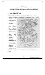
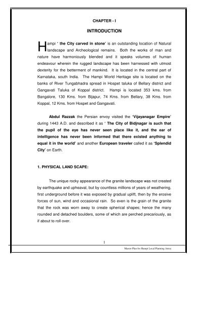
Hampi ‘ the City carved in stone’ is an outstanding location of Naturallandscape and Archeological remains. Both the works of man andnature have harmoniously blended and it speaks volumes of humanendeavour wherein the rugged landscape has been harnessed with utmostdexterity for the betterment of mankind. It is located in the central part ofKarnataka, south India. The Hampi World Heritage site is located on thebanks of River Tungabhadra spread in Hospet taluka of <strong>Bellary</strong> district andGangavati Taluka of Koppal district. Hampi is located 353 kms. fromBangalore, 130 Kms. from Bijapur, 74 Kms. from <strong>Bellary</strong>, 38 Kms. fromKoppal, 12 Kms. from Hospet and Gangavati.Abdul Razzak the Persian envoy visited the ‘Vijayanagar Empire’during 1443 A.D. and described it as ‘ The City of Bidjnagar is such thatthe pupil of the eye has never seen place like it, and the ear ofintelligence has never been informed that there existed anything toequal it in the world’ and another European traveler called it as ‘SplendidCity’ on Earth.1. PHYSICAL LAND SCAPE:The unique rocky appearance of the granite landscape was not createdby earthquake and upheaval, but by countless millions of years of weathering,first underground before it was exposed by gradual uplift, then by the erosiveforces of sun, wind and occasional rain. So even is the grain of the granitethat the rock was worn away to create spherical shapes; hence the manyrounded and detached boulders, some of which are perched precariously, asif about to roll over.1Master Plan for Hampi Local Planning Areea
The Tungabhadra River traverses the Hampi landscape. Flowing in anortheasterly direction the river has cut its way through weaker, morefractured rocky terrain, creating a narrow gorge. For some distance, granitehills hem I the river, the highest of which are Matanga hill on the south bank,rising 115 meters above the river, and Anjanadri hill near the north bank,almost 140 meters high. Flooding has worn away the rocks that border theriver, creating islands, lagoons and small pools. A parallel valley to the southmarks an alternate course where the river overflowed during wet periods. Yetfurther south, the granite outcrops gradually disappear and the landscapeopens out in to a broad plain. This continues for more than 10 kilometersbefore ending at the rising slopes of the Sandur hills beyond the modern townof Hospet. These hills are rich in iron and manganese and are now subject tointensive strip mining.Hampi (Hospet taluka, <strong>Bellary</strong> district) situated on the colourful sinuoushilly banks of the river Tungabhadra with green patches of plants and trees, isundoubtedly the most spectacular site of innumerable monuments of varietiesand forms, simple and grand thickly spread over a vast area but virtually all inpensive state of ruins, a mute witness to an era of glories, triumphs andtragedies. The cultural heritage of once the most prosperous and flourishingroyal capital of a mighty kingdom, are so majestic and imposing that theyleave the visitor totally dumbfounded, awestruck and humbled, may evenphilosophically introspective. Yes, the famous capital of the kings ofVijayanagara has now become the focal point as it attracts attention and greatadmiration of architects, historians, and archaeologists, and of course theinnumerable tourists from all over the world who visit these monuments.2. CLIMATE:<strong>Bellary</strong> district lies in the dry and arid climatic zone. The climate in theHampi is dry, but due to irrigation activities, the area is humid hot. Thesummer is generally hot compared to other parts of the state. Thetemperature begins to rise steadily with commencement of summer fromFebruary to May. Generally March and April happens to be the hottest month2Master Plan for Hampi Local Planning Areea
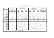
with maximum temperature reaching as high as 43 0 C and 44 0 C and theminimum temperature is recorded during December with 12 0 C to 13 0 C. Thewind generally blows from south west to north east direction and north east tosouth west. Though the area comes under dry zone, due to Tungabhadrareservoir and irrigation the humidity is comparatively more with maximumhumidity reaching 96% from July to November and the minimum humidityduring March and April.The area is generally classified as moderate to low rainfall receivingarea. The average rainfall varies from 800 mm. to 900 mm. The rainfall forthe last 12 years has shown that 1997 and 2002 have registered the lowestrainfall of 391 mm. and 389 mm. respectively. The highest rainfall isreceived during 2005 with 1150 mm. Generally the July and August monthsare receiving highest rainfall with 130 to 140 mm. and April and November arelowest rainfall receiving months with 3 mm. to 5 mm. The December,February and March are receiving no rainfall.3. ‘HERITAGE AREA’ OR LOCAL PLANNING AREA:The ‘Heritage Area’ defined under the Hampi World Heritage AreaManagement Authority Act, 2002 shall be a Local Planning Area declaredunder section 35-sub section (2) of this Act. As per Hampi World HeritageArea Management Authority Act, 2002, the entire area as old Notificationmeasures 135.00 SQKms. (Core, Buffer and Peripheral Zone). There are30 villages, 15 from Hospet taluka and 15 from Gangavati taluka. (please seeMap)The Hampi World Heritage Area Management Authority constituted (9-04-2003) under Hampi World Heritage Area Management Authority Act 2002shall be a Local Planning Authority for the Local Planning Area comprising the‘Heritage Area’ under section 81 D and 81 E of Karnataka Town and CountryPlanning Act 1961. The Local Planning Area for ‘Hampi World HeritageArea’ has been first declared on 1-12-2004. It was felt during many3Master Plan for Hampi Local Planning Areea
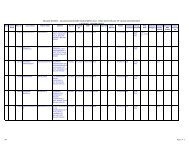
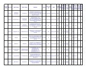
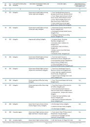
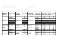
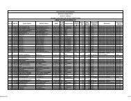
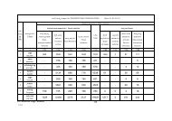
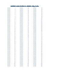
deliberations/discussions with various experts including UNESCO that thepresent Local Planning Area boundary shall revised by including entirerevenue villages. And accordingly it was decided extend the Local PlanningArea by including entire revenue villages and excluding the Karignur village inHWHAMA’s meeting held on 24-3-2006 and a proposal was sent to theGovernment for approval on 25-3-2006. According the Government hasapproved the proposal and the Local Planning Area extended/revised on…………..by including entire revenue villages wide G.O.No………………… Asper this notification there are only 29 revenue villages within the Local PlaningArea. As per new notification the Local Planning Area, (please see map)which measures 236.46 SQKMs., has Core Zone, (41.8 SQKMs.)LIST OF VILLAGES COMING WITHIN THE LOCAL PLANNING AREAHWHAMAHOSPET TALUKASl.NoTalukaName of thevillageArea inHectaresPopulationRemarks1 Hospet Hampi 343.64 2134 Entire Revenue village2 Hospet Krishnapur3 Hospet Singanathanahalli4 Hospet Nimbapur92.71 105 Entire Revenue village162.91 23 Entire Revenue village126.27 -- Entire Revenue village5 Hospet Kaddirampura 304.28 1280 Entire Revenue village6 Hospet Dhanapura183.66 227 Entire Revenue village7 Hospet Mallappanagudi 1043.39 8255 Entire Revenue village8 Hospet Nagenahalli9 Hospet Gudiobalapura413.40 3989 Entire Revenue village475.30 1600 Entire Revenue village10 Hospet Kamalapura 8882.46 21,811 Entire Revenue village11 Hospet Bukkasagara1403.75 3912 Entire Revenue village12 Hospet Venkatapura 2963.32 2431 Entire Revenue village13 Hospet Kalagatta691.28 141 Entire Revenue village14 Hospet Kondanayakanahalli169.24 2216 Entire Revenue villageTotal 17,255.61 45,9084Master Plan for Hampi Local Planning Areea
LIST OF VILLAGES COMING WITHIN THE LOCAL PLANNING AREAHWHAMAGANGAVATHI TALUKASl.Name of the Area inTalukaNo.village HectaresPopulation Remarks15 Gangavathi Anegundi 721.91 3497 Entire Revenue village16 Gangavathi Thirumalapura 283.51 273 Entire Revenue village17 Gangavathi Sanapura 664.82 1691 Entire Revenue village18 Gangavathi Virupapuragudda 331.69 261 Entire Revenue village19 Gangavathi Hanumanahalli 187.53 413 Entire Revenue village20 Gangavathi Anjanahalli 192.38 290 Entire Revenue village21 Gangavathi Chikkarampura 377.84 563 Entire Revenue village22 Gangavathi Lakshmipura 1010.65 76 Entire Revenue village23 Gangavathi Rampura 330.40 2041 Entire Revenue village24 Gangavathi Krishnapura 81.50 104 Entire Revenue village25 Gangavathi Ramadurga 158.36 660 Entire Revenue village26 Gangavathi Mallapura 954.28 2757 Entire Revenue village27 Gangavathi Basavanadurga 549.13 1012 Entire Revenue village28 Gangavathi Singanagunda 166.02 21 Entire Revenue village29 Gangavathi Rangapura 380.20 374 Entire Revenue villageTOTAL 6390.22 14,033Grand Total 23,645.86 59,941Buffer (53.00 SQKms) and Pheriperal Zones (141.66 SQKms). The detailsof villages that are coming within the ‘Heritage Area or the Local PlanningArea’ of Hampi are given in the above table both for Hospet and Gangavathitalukas. The Local Planning Area measures 236.46 SQKMs. and nearly172 SQKms. of area lies to the south of the River and 64 SQKms. of area tothe north of the river.The Core Zone’ comprising ‘World Heritage site’ and 8 othersettlements measures 41.8 SQKm. and is surrounded and protected byBuffer zone. Out of 8 settlements 4 are having 5, 21, 55 and households andNimbapur is uninhabited. Therefore, only 4 settlements like Kamalpaur,Anegundi, Hampi and Kaddiramapur are considered important and detailedstudies and plans have been prepared after carrying out various survey’s.5Master Plan for Hampi Local Planning Areea