The TOPMODEL Topographic Index In JULES
The TOPMODEL Topographic Index In JULES The TOPMODEL Topographic Index In JULES
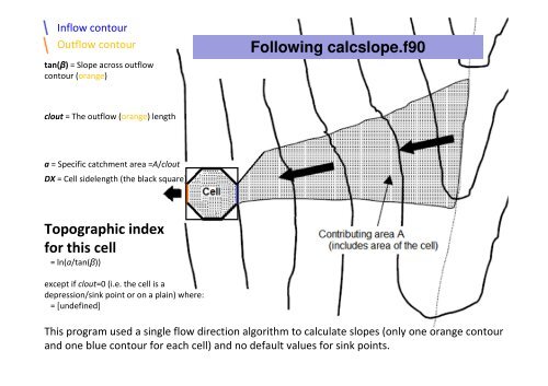
Inflow contourOutflow contourtan(β) = Slope across outflowcontour (orange)Following calcslope.f90clout = The outflow (orange) lengtha = Specific catchment area =A/cloutDX = Cell sidelength (the black square)Topographic indexfor this cell= ln(a/tan(β))except if clout=0 (i.e. the cell is adepression/sink point or on a plain) where:= [undefined]This program used a single flow direction algorithm to calculate slopes (only one orange contourand one blue contour for each cell) and no default values for sink points.
Inflow contourOutflow contourFollowing Option #4All as for GRIDATB inc. defaultvaluesTopographic indexfor this cell= ln(a/tan(β))Single inflow and outflow, but contributing areas A are validated by HydroSHEDS to correspondmore closely with more sophisticated routing models.
- Page 1: The TOPMODEL TopographicIndex In JU
- Page 5 and 6: A calculator for the TOPOGRAPHIC IN
- Page 7: Inflow contourOutflow contourtan(β
- Page 12 and 13: Here’s what you get from topidx.c
- Page 14 and 15: Here’s what you get from calcslop
- Page 17: HydroSHEDSDEM andcontributingareasc
- Page 23 and 24: Marthews TR, Dadson SJ & Lehner BL
- Page 25: TobyMarthewsEdinburgh, 20th Jun 201
<strong>In</strong>flow contourOutflow contourtan(β) = Slope across outflowcontour (orange)Following calcslope.f90clout = <strong>The</strong> outflow (orange) lengtha = Specific catchment area =A/cloutDX = Cell sidelength (the black square)<strong>Topographic</strong> indexfor this cell= ln(a/tan(β))except if clout=0 (i.e. the cell is adepression/sink point or on a plain) where:= [undefined]This program used a single flow direction algorithm to calculate slopes (only one orange contourand one blue contour for each cell) and no default values for sink points.


