An Update Based on 2007 Aerial Photographs - Waikato Regional ...
An Update Based on 2007 Aerial Photographs - Waikato Regional ...
An Update Based on 2007 Aerial Photographs - Waikato Regional ...
- No tags were found...

You also want an ePaper? Increase the reach of your titles
YUMPU automatically turns print PDFs into web optimized ePapers that Google loves.
<strong>Waikato</strong> Regi<strong>on</strong>al Council Technical Report 2011/29Geothermal Vegetati<strong>on</strong> of the<strong>Waikato</strong> Regi<strong>on</strong> - <str<strong>on</strong>g>An</str<strong>on</strong>g> <str<strong>on</strong>g>Update</str<strong>on</strong>g><str<strong>on</strong>g>Based</str<strong>on</strong>g> <strong>on</strong> <strong>2007</strong> <strong>Aerial</strong><strong>Photographs</strong>www.waikatoregi<strong>on</strong>.govt.nzISSN 2230-4355 (Print)ISSN 2230-4363 (Online)
Prepared by:Wildland C<strong>on</strong>sultants LtdFor:<strong>Waikato</strong> Regi<strong>on</strong>al CouncilPrivate Bag 3038<strong>Waikato</strong> Mail CentreHAMILTON 3240July 2011Document #: 2063137
Approved for release by:Ed BrownDate October 2011DisclaimerThis technical report has been prepared for the use of <strong>Waikato</strong> Regi<strong>on</strong>al Council as a referencedocument and as such does not c<strong>on</strong>stitute Council’s policy.Council requests that if excerpts or inferences are drawn from this document for further use byindividuals or organisati<strong>on</strong>s, due care should be taken to ensure that the appropriate c<strong>on</strong>texthas been preserved, and is accurately reflected and referenced in any subsequent spoken orwritten communicati<strong>on</strong>.While <strong>Waikato</strong> Regi<strong>on</strong>al Council has exercised all reas<strong>on</strong>able skill and care in c<strong>on</strong>trolling thec<strong>on</strong>tents of this report, Council accepts no liability in c<strong>on</strong>tract, tort or otherwise, for any loss,damage, injury or expense (whether direct, indirect or c<strong>on</strong>sequential) arising out of the provisi<strong>on</strong>of this informati<strong>on</strong> or its use by you or any other party.Doc # 2063137
Doc #: 2063137
GEOTHERMAL VEGETATION OF THEWAIKATO REGION - AN UPDATEBASED ON <strong>2007</strong> AERIAL PHOTOGRAPHS
Geothermal Vegetati<strong>on</strong> of the <strong>Waikato</strong> Regi<strong>on</strong> - <str<strong>on</strong>g>An</str<strong>on</strong>g> <str<strong>on</strong>g>Update</str<strong>on</strong>g><str<strong>on</strong>g>Based</str<strong>on</strong>g> <strong>on</strong> <strong>2007</strong> <strong>Aerial</strong> <strong>Photographs</strong>C<strong>on</strong>tract Report No. 2348Project Team:Wildland C<strong>on</strong>sultants LtdChris Bycroft - Report preparati<strong>on</strong>, field work.Sarah Beadel - Peer review, report preparati<strong>on</strong>.Lisette Collins - Report preparati<strong>on</strong>, field work.Mieke Kapa - Report preparati<strong>on</strong>, field work.Jo McQueen-Watt<strong>on</strong> - Report preparati<strong>on</strong>.Fi<strong>on</strong>a Wilcox - Report preparati<strong>on</strong>.Roger Bawden and Marle Rossouw - GIS.Geophysical AssessmentsManfred Hochstein (<strong>2007</strong> assessments; University of Auckland)Juliet News<strong>on</strong> (2010 assessments; Independent C<strong>on</strong>sultant, Mt Albert, Auckland)Julian McDowall (2010 assessments; Independent C<strong>on</strong>sultant, Herne Bay, Auckland)Prepared for:<strong>Waikato</strong> Regi<strong>on</strong>al CouncilPrivate Bag 3038<strong>Waikato</strong> Mail CentreHamilt<strong>on</strong> 3240July 201199 SALA STREET, Whakarewarewa, 3010, P.O. BOX 7137, TE NGAE, ROTORUA 3042Ph 07-343-9017; Fax 07-343-9018, email ecology@wildlands.co.nz, www.wildlands.co.nz
SUMMARYThis study was undertaken for <strong>Waikato</strong> Regi<strong>on</strong>al Council and provides an updated inventoryof the current distributi<strong>on</strong> and extent of geothermal vegetati<strong>on</strong>, and assessment of the relativesignificance of each site based <strong>on</strong> <strong>2007</strong> aerial photographs and field survey of selected sitesduring 2010 and 2011. Approximately 70% of the extent of New Zealand‟s geothermalvegetati<strong>on</strong> occurs within the <strong>Waikato</strong> Regi<strong>on</strong>. Associated with geothermal sites arecharacteristic plant species and vegetati<strong>on</strong> types. These include plants capable of survivinghigh soil temperatures, disjunct populati<strong>on</strong>s found a c<strong>on</strong>siderable distance from other plantsof the same species which are usually c<strong>on</strong>fined to warmer climates, and local endemicspecies and distinct genetic forms arising where ground temperatures are sufficiently stable.Many geothermal sites are dynamic and unstable and changes in surface geothermal activityare reflected in changes in the extent and compositi<strong>on</strong> of geothermal vegetati<strong>on</strong>. Thegeothermal vegetati<strong>on</strong> of the <strong>Waikato</strong> Regi<strong>on</strong> includes populati<strong>on</strong>s of several plant specieswhich in New Zealand have a nati<strong>on</strong>al threat ranking.For this survey, c.734 ha of geothermal vegetati<strong>on</strong> (including n<strong>on</strong>vegetated raw-soilfield)over 64 sites in fifteen geothermal fields was described, mapped, and ranked from fieldsurveys and existing informati<strong>on</strong>. <str<strong>on</strong>g>An</str<strong>on</strong>g> additi<strong>on</strong>al c.106 ha was mapped as geothermal waterwhere it was an integral part of a geothermal site. The grouping of individual areas ofgeothermal habitats as sites can be somewhat arbitrary, however groupings are generallybased <strong>on</strong> areas of geothermal surface manifestati<strong>on</strong>s that are located nearby each other, andare easy to discuss together as a single unit. There are likely to be some small areas ofunmapped geothermal vegetati<strong>on</strong> <strong>on</strong> hill slopes above Tokaanu that have not been mapped inthis report. Geothermal vegetati<strong>on</strong> and habitats were mapped into three broad categories,n<strong>on</strong>vegetated raw-soilfield (c.92 ha in the <strong>Waikato</strong> Regi<strong>on</strong>), emergent wetland (c.81 ha in the<strong>Waikato</strong> Regi<strong>on</strong>) and terrestrial vegetati<strong>on</strong> (c.561 ha in the <strong>Waikato</strong> Regi<strong>on</strong>). Terrestrialvegetati<strong>on</strong> is all vegetati<strong>on</strong> that was not mapped as geothermal wetland, and n<strong>on</strong>vegetatedraw-soilfield and includes (but is not limited to) forest, scrub, shrubland, fernland andmossfield. For 19 sites, a geophysical assessment was carried out.The vegetati<strong>on</strong> of each site has been described and classified using predefined vegetati<strong>on</strong>structural classes and a protocol for assigning type names based <strong>on</strong> the dominant plantspecies. Site c<strong>on</strong>diti<strong>on</strong>, current threats, modificati<strong>on</strong>s and vulnerability were assessed, andmanagement requirements outlined. Each site was assessed for significance and thenassigned a relative significance level of Internati<strong>on</strong>al, Nati<strong>on</strong>al, Regi<strong>on</strong>al, or Local.Significance and relative significance were assessed using the criteria in the <strong>Waikato</strong>Regi<strong>on</strong>al Policy Statement (applying the guidelines delineated in 2002 updated in accordancewith the revised threat classificati<strong>on</strong> lists). Vegetati<strong>on</strong> type boundaries have been digitisedand the extent calculated of each geothermal vegetati<strong>on</strong> type. Topographical locati<strong>on</strong> mapsof each site are provided and vegetati<strong>on</strong> maps of each site are presented in this report.Each of the 64 sites meets <strong>on</strong>e or more of the criteria for ecological significance in the<strong>Waikato</strong> Regi<strong>on</strong>al Policy Statement and each site was ranked as being of Internati<strong>on</strong>al,Nati<strong>on</strong>al, Regi<strong>on</strong>al oror Local Significance. Four sites were ranked as being of Internati<strong>on</strong>alSignificance and part of <strong>on</strong>e of other site (with other parts of this site being ranked asRegi<strong>on</strong>al and Local Significance), encompassing c.205 ha or 24% percent of the geothermalvegetati<strong>on</strong> in the <strong>Waikato</strong> Regi<strong>on</strong>. Eight sites were of Nati<strong>on</strong>al Significance, with two sites© 2011C<strong>on</strong>tract Report No. 2348
eing partly of Nati<strong>on</strong>al Significance and partly of Local Significance encompassing c.382 haor 46% of geothermal habitat in the <strong>Waikato</strong> Regi<strong>on</strong>. Twenty-three sites were identified asbeing of Regi<strong>on</strong>al significance, with an additi<strong>on</strong>al two sites being partly of Regi<strong>on</strong>al andLocal significance. In total, c.242 ha or 29% of geothermal habitat in the <strong>Waikato</strong> Regi<strong>on</strong>was identified as being Regi<strong>on</strong>ally Significant. The remainder of sites (25) were identified asbeing of Local Significance (c.11 ha or c.1% of geothermal habitat).Wildland C<strong>on</strong>sultants (2004) used Ecological Districts as the framework of the study. Whileecological districts are used to show the distributi<strong>on</strong> of geothermal sites in the landscape,greater emphasis is placed <strong>on</strong> recognised Geothermal Fields in this report. Geothermal Fieldsare more likely to show differences in character between geothermal sites than ecologicaldistricts as sites within the same geothermal field are thought to be sourced from the samegeothermal reservoir, which is the source of water in geothermal surface manifestati<strong>on</strong>s. Thecharacter of 17 Geothermal Fields are described in this report, with geothermal vegetati<strong>on</strong>mapped and described for sites. The following areas of geothermal vegetati<strong>on</strong> were mappedin each geothermal field by size: Waiotapu (c.221 ha), Wairakei-Tauhara (c.151 ha),Rotokawa (c.104 ha), Tokaanu-Waihi-Hipaua (c.60 ha), Te Kopia (c.60 ha), Orakeikorako(c.58 ha), T<strong>on</strong>gariro (c.25 ha), Waikite (c.25 ha), Ohaaki (c.19 ha), Reporoa (c.7 ha), Mokai(c.3 ha), Ngatamariki (c.2 ha), Atiamuri (c.0.1 ha); two fields have less than 0.1 ha ofgeothermal vegetati<strong>on</strong> (Horohoro and Whangairorohea), and two fields have no knowngeothermal vegetati<strong>on</strong> (Mangakino and Horomatangi).The majority of geothermal vegetati<strong>on</strong> in the <strong>Waikato</strong> Regi<strong>on</strong> occurs in Atiamuri EcologicalDistrict (c.86%), while Taupo and T<strong>on</strong>gariro Ecological Districts c<strong>on</strong>tain c.9% and c.5% ofthe vegetati<strong>on</strong> of the regi<strong>on</strong> respectively. Geothermal vegetati<strong>on</strong> in the <strong>Waikato</strong> Regi<strong>on</strong> isdistributed relatively evenly between two local authorities; Rotorua District (51%) and TaupoDistrict (c.49%).Historical site changes were assessed using a combinati<strong>on</strong> of historical photos and existingliterature. The extent of geothermal vegetati<strong>on</strong> was found to have decreased in 23 sitesbetween the 1940s or 1960s and the present day. In six sites, the extent of geothermalvegetati<strong>on</strong> has increased compared to what was historically present. There has been nodiscernible change to the extent in vegetati<strong>on</strong> cover at eight sites. No informati<strong>on</strong> was able tobe found for the remainder of the sites.In the Atiamuri Ecological District there has been a significant decline, estimated to beapproximately 30%, in the extent of geothermal vegetati<strong>on</strong> since European settlement.However there has been an estimated gain of approximately 4% in the Taupo EcologicalDistrict. The overall decline in geothermal vegetati<strong>on</strong> is the result of a number of factors.These include energy and hot water draw-off from the geothermal fields, damming of the<strong>Waikato</strong> River to form Lake Ohakuri, clearance and burning of vegetati<strong>on</strong>, weed invasi<strong>on</strong>,livestock grazing, modificati<strong>on</strong> of groundwater tables, dumping of rubbish, and otheractivities associated with forestry, farming, tourism, and recreati<strong>on</strong>. The ecologicalsustainability of geothermal vegetati<strong>on</strong> in the <strong>Waikato</strong> Regi<strong>on</strong> is under <strong>on</strong>going threat fromplant and animal pests and from the activities of humans, especially <strong>on</strong> private land.M<strong>on</strong>itoring, protecti<strong>on</strong>, and restorati<strong>on</strong>, wherever possible, are essential to halt the decline ofthese fragile and unique ecosystems.© 2011C<strong>on</strong>tract Report No. 2348
CONTENTSSUMMARY 11. INTRODUCTION 12. PREVIOUS WORK 43. METHODOLOGY 53.1 Existing informati<strong>on</strong> 53.2 Ecological districts 53.3 Field survey 53.4 Geophysical properties 63.5 Vegetati<strong>on</strong> and habitat types 73.6 Threats/modificati<strong>on</strong>/vulnerability 153.7 Site mapping 153.8 Historical site changes 153.9 Assessment of botanical significance by Given (1996) 153.10 Ecological evaluati<strong>on</strong> 163.11 Data analysis data 163.12 Presentati<strong>on</strong> of results 164. DEFINITION OF GEOTHERMALLY INFLUENCED VEGETATION 244.1 Basis of summarising extent of geothermal habitat, geothermalvegetati<strong>on</strong>, and open water 244.2 Geothermal wetland vegetati<strong>on</strong> 244.3 N<strong>on</strong>vegetated raw-soilfield (Source: Merrett & Clarks<strong>on</strong> 1999) 254.3.1 Basis of mapping of n<strong>on</strong>vegetated raw-soilfield for thisstudy 265. GEOTHERMAL SITES IN THE WAIKATO REGION 266. GEOTHERMAL VEGETATION OF THE WAIKATO REGION - ANOVERVIEW 316.1 Assessment by geothermal field 316.2 Assessment by Local Authority District 426.3 Assessment by Ecological District 427. CHANGES IN EXTENT OF GEOTHERMAL SITES BETWEEN1940s/1950s AND <strong>2007</strong> 438. CHANGES IN EXTENT OF GEOTHERMAL SITES (2002 AND <strong>2007</strong>AERIAL PHOTOS) 459. NATURAL DYNAMICS 5310. HUMAN DISTURBANCE AND ASSOCIATED THREATS 53© 2011C<strong>on</strong>tract Report No. 2348
11. FUTURE MANAGEMENT 5611.1 Regulatory c<strong>on</strong>trols 5611.2 Buffers and c<strong>on</strong>necti<strong>on</strong>s 5711.3 Land status and protecti<strong>on</strong> 5711.4 Ecological restorati<strong>on</strong> 57ACKNOWLEDGMENTS 57REFERENCES AND SELECTED BIBLIOGRAPHY 58APPENDICES1. Site descripti<strong>on</strong>s 721.1 Horohoro Geothermal Field 741.2 Waikite Geothermal Field 781.3 Waiotapu Geothermal Field 1031.4 Mokai Geothermal Field 1571.5 Atiamuri Geothermal Field 1791.6 Te Kopia Geothermal Field 1911.7 Orakeikorako Geothermal Field 2321.8 Ngatamariki Geothermal Field 2651.9 Whangairorohea Geothermal Field 2751.10 Reporoa Geothermal Field 2791.11 Ohaaki Geothermal Field 3131.12 Wairakei-Tauhara Geothermal Field 3251.13 Rotokawa Geothermal Field 4021.14 Tokaanu-Waihi-Hipaua Geothermal Field 4141.15 T<strong>on</strong>gariro Geothermal Field 4522. Sites for which field inspecti<strong>on</strong>s were made as part of this study 4683. Sites for which field inspecti<strong>on</strong>s were not undertaken as part of this study 4704. Notes <strong>on</strong> the vascular flora of geothermal areas 4755. Bioclimatic z<strong>on</strong>es (Source: Leathwick et al. 1995) 4826. Habitats for geothermal vegetati<strong>on</strong> (Source: Merrett & Clarks<strong>on</strong> 1999) 4837. Vegetati<strong>on</strong> classes (definiti<strong>on</strong>s for those classes used in this report)8. Abbreviati<strong>on</strong>s and symbols 4879. Comm<strong>on</strong> plant names used in text 48810. <str<strong>on</strong>g>Update</str<strong>on</strong>g>d <strong>Waikato</strong> Regi<strong>on</strong>al Council criteria for the evaluati<strong>on</strong> ofindigenous vegetati<strong>on</strong> and habitats of indigenous fauna 49111. <str<strong>on</strong>g>Update</str<strong>on</strong>g>d <strong>Waikato</strong> Regi<strong>on</strong>al Council criteria for the assessment ofrelative ecological significance of Indigenous vegetati<strong>on</strong> and habitatsof indigenous fauna 50112. Threat classificati<strong>on</strong>s system 509INDEX 515© 2011C<strong>on</strong>tract Report No. 2348
LIST OF TABLES1. Sites and dates for which geophysical assessments were carried out. Theassessments are included in the site reports c<strong>on</strong>tained in Appendix 1. 62. List of geothermal vegetati<strong>on</strong> types and habitats. (Note this table includesvegetati<strong>on</strong> types identified in Wildland C<strong>on</strong>sultants (2004) and a study ofgeothermal vegetati<strong>on</strong> in the Bay of Plenty Regi<strong>on</strong> (Wildland C<strong>on</strong>sultants2005), not all of which occur in the <strong>Waikato</strong> Regi<strong>on</strong>. 73. Cover class index (from Allen 1992). 154. Format and categories for presentati<strong>on</strong> of informati<strong>on</strong> <strong>on</strong> geothermalsites. 175. Breakdown of broad geothermal hydroclass and vegetati<strong>on</strong> groupswithin each site ordered by geothermal field and ranked by area ofgeothermal vegetati<strong>on</strong>, <strong>Waikato</strong> Regi<strong>on</strong>. 216. Ecological significance ranking of geothermal sites ordered by geothermalfield, <strong>Waikato</strong> Regi<strong>on</strong>. 277. Geothermal sites for which the level of significance has been revised between<strong>2007</strong> and 2011. 308. Area of geothermal vegetati<strong>on</strong> (includes terrestrial vegetati<strong>on</strong>, n<strong>on</strong>vegetatedraw-soilfield and wetland, but not geothermal water) in the <strong>Waikato</strong> Regi<strong>on</strong> inthe Rotorua and Taupo Districts. 429. Area of geothermal vegetati<strong>on</strong> (includes terrestrial vegetati<strong>on</strong>, n<strong>on</strong>vegetatedraw-soilfield and wetland, but not geothermal water) and geothermal water inthe <strong>Waikato</strong> Regi<strong>on</strong> of the Atiamuri, Rotorua Lakes, Taupō, and T<strong>on</strong>gariroEcological Districts. 4310. Summary of changes in extent and compositi<strong>on</strong> of geothermal vegetati<strong>on</strong> andhabitats between historical photos and <strong>2007</strong> aerial photographs. 4411. Changes in extent of each site between 2002 and <strong>2007</strong> aerial photos (asmapped in Wildland C<strong>on</strong>sultants 2004, 2006, <strong>2007</strong>a & b and current report). 46© 2011C<strong>on</strong>tract Report No. 2348
Reviewed and approved for release by:_______________________Sarah BeadelDirectorWildland C<strong>on</strong>sultants LtdThis report should be cited as:Wildland C<strong>on</strong>sultants 2011: Geothermal vegetati<strong>on</strong> of the <strong>Waikato</strong> Regi<strong>on</strong> - <str<strong>on</strong>g>An</str<strong>on</strong>g> updatebased <strong>on</strong> <strong>2007</strong> aerial photographs. Wildland C<strong>on</strong>sultants Ltd C<strong>on</strong>tract Report No. 2348.Prepared for <strong>Waikato</strong> Regi<strong>on</strong>al Council. 515 pp.Wildland C<strong>on</strong>sultants Ltd 2011This report has been produced by Wildland C<strong>on</strong>sultants Ltd for <strong>Waikato</strong> Regi<strong>on</strong>al Council.Wildland C<strong>on</strong>sultants accepts no resp<strong>on</strong>sibility for any use of, or reliance <strong>on</strong> any c<strong>on</strong>tents ofthis Report by any pers<strong>on</strong> other than <strong>Waikato</strong> Regi<strong>on</strong>al Council. This informati<strong>on</strong> may becopied or redistributed to others without limitati<strong>on</strong>, provided Wildland C<strong>on</strong>sultants Ltd isacknowledged as the source of informati<strong>on</strong>.© 2011 C<strong>on</strong>tract Report No. 2348
1. INTRODUCTIONThis study was undertaken for <strong>Waikato</strong> Regi<strong>on</strong>al Council and provides an inventoryof the current distributi<strong>on</strong> and extent of geothermal vegetati<strong>on</strong> in the Regi<strong>on</strong>, andassessment of the relative significance of each site. This informati<strong>on</strong> will enablemanagement of the varied characteristics of the geothermal resource, as required bythe <strong>Waikato</strong> Regi<strong>on</strong>al Policy Statement. This report collates informati<strong>on</strong> from anumber of previous reports undertaken by Wildland C<strong>on</strong>sultants for <strong>Waikato</strong>Regi<strong>on</strong>al Council between 2004 and <strong>2007</strong>, as well as updated informati<strong>on</strong> based <strong>on</strong>site inspecti<strong>on</strong>s of selected sites, improved knowledge about sites from other studies,and inspecti<strong>on</strong> of better quality aerial photographs (<strong>2007</strong> WRAPS 1 ) than were presentduring the 2004 study (which was based <strong>on</strong> 2002 aerial photographs).The <strong>Waikato</strong> Regi<strong>on</strong> is located in the upper part of central North Island. It extendsfrom Coromandel-Colville in the north to Mt Ruapehu in the south; as far west asMokau, and east to include part of Kaingaroa Forest (refer to Figure 1). The <strong>Waikato</strong>Regi<strong>on</strong> comprises part or all of 34 ecological districts, three of which, AtiamuriEcological District, Taupo Ecological District and T<strong>on</strong>gariro Ecological District,c<strong>on</strong>tain all areas of geothermal vegetati<strong>on</strong> larger than 1 hectare. While small isolatedsurface geothermal expressi<strong>on</strong>s occur elsewhere in the <strong>Waikato</strong>, in general they arevery small (usually small surface springs) and are not known to c<strong>on</strong>tain anygeothermal vegetati<strong>on</strong> of ecological significance. Many of these have been c<strong>on</strong>vertedinto hot pools, while others are hot springs am<strong>on</strong>gst sand <strong>on</strong> the ocean edge that d<strong>on</strong>ot support any vegetati<strong>on</strong>.Wildland C<strong>on</strong>sultants (2004) used ecological districts as the framework for the study.While ecological districts are used to show the distributi<strong>on</strong> of geothermal sites in thelandscape, greater emphasis is placed <strong>on</strong> recognised geothermal fields in the updatedproject. Geothermal fields are more likely to show differences in character betweengeothermal sites than ecological districts as sites within the same geothermal field arethought to be sourced from the same geothermal reservoir, which is the source ofwater in geothermal surface manifestati<strong>on</strong>s. Assessments based <strong>on</strong> ecologicaldistricts become an issue where the same geothermal field extends across twoecological districts, as occurs at Tokaanu-Waihi-Hipaua geothermal field (T<strong>on</strong>gariroand Taupo Ecological Districts) and Wairakei-Tauhara Geothermal Field (Atiamuriand Taupo Ecological Districts).Almost 80% of New Zealand’s geothermal systems occur within the <strong>Waikato</strong> Regi<strong>on</strong>(Envir<strong>on</strong>ment <strong>Waikato</strong> 1998). Associated issues and values range from exploitativeresource use, such as thermal energy extracti<strong>on</strong> and the utilisati<strong>on</strong> of mineralisedfluids, to historical, amenity, cultural, spiritual, c<strong>on</strong>servati<strong>on</strong> and scientific values(Envir<strong>on</strong>ment <strong>Waikato</strong> 1998; Merrett & Clarks<strong>on</strong> 1999) and the envir<strong>on</strong>mentalmanagement objectives of <strong>Waikato</strong> Regi<strong>on</strong>al Council are derived from these. Theobjectives are to maintain the variety of characteristics and to achieve protecti<strong>on</strong> andefficient take of the regi<strong>on</strong>al geothermal resource (Envir<strong>on</strong>ment <strong>Waikato</strong> 1998). Pestplants and pest animals are degrading ecological values at many sites and if these arenot c<strong>on</strong>trolled then the ecological values of these sites are likely to decline. Tourismoperati<strong>on</strong>s at geothermal sites are also of significant ec<strong>on</strong>omic importance to the1WRAPS = <strong>Waikato</strong> Regi<strong>on</strong> <strong>Aerial</strong> Photograph Syndicate.© 2011 1 C<strong>on</strong>tract Report No. 2348
egi<strong>on</strong>. Other ec<strong>on</strong>omic uses, such as power generati<strong>on</strong>, may have negative impacts<strong>on</strong> ecological and geophysical characteristics of geothermal sites, and aspects oftourism operati<strong>on</strong>s at sites also require m<strong>on</strong>itoring to ensure sites are not degraded.Geothermal areas are often characterised by unusual assemblages of plants, such asdisjuncts which are normally found in climates warmer than that of the surroundingregi<strong>on</strong>, plants capable of surviving high soil temperatures or hydrothermically alteredsoils (Given 1980) and local genetic forms arising where ground temperatures aresufficiently stable.This report updates the 2004 report (Wildland C<strong>on</strong>sultants 2004), and incorporatesextra informati<strong>on</strong> about geothermal sites collected in 2006 and <strong>2007</strong> (WildlandC<strong>on</strong>sultants 2006, <strong>2007</strong>a&b). Selected sites were revisited in 2010 and 2011 for thisreport. Vegetati<strong>on</strong> maps and descripti<strong>on</strong>s have been updated using new vegetati<strong>on</strong>descripti<strong>on</strong>s and codes, including the additi<strong>on</strong> of broad vegetati<strong>on</strong> classes. New codesfor sites have been used to replace the codes based <strong>on</strong> the New ZealandTopographical map series NZMS260, which is no l<strong>on</strong>ger in use. New site codesrelate to the geothermal field each site in located in. Threatened species rankingshave been updated using de Lange et al. (2009) for plants and Miskelly et al. (2008)for birds. Additi<strong>on</strong>al informati<strong>on</strong> has been included from the 2004 report, includinginformati<strong>on</strong> <strong>on</strong> site changes (generally either since the last field survey, or within thelast ten years, if known); historical site changes; and incorporati<strong>on</strong> of more faunainformati<strong>on</strong> where available. Historical site change assessments were determinedthrough examinati<strong>on</strong> of aerial photographs held by <strong>Waikato</strong> Regi<strong>on</strong>al Council frombetween 1941-1961 and compared with recent (<strong>2007</strong>) aerial photographs to determinethe extent of change of geothermal sites over this timeframe. A summary of changesthat could be clearly identified are presented for each site.The ecological significance of each site was reassessed as either being ofinternati<strong>on</strong>al, nati<strong>on</strong>al, regi<strong>on</strong>al, or local significance as determined by the updatedcriteria defined in the <strong>Waikato</strong> Regi<strong>on</strong>al Policy Statement (2002). This has beenrevised to reflect more recent changes to the New Zealand Threat Classificati<strong>on</strong> Lists(refer to Appendices 10 and 11). Ecosystem Ranking assessments were completed forall sites with a relative significance of Regi<strong>on</strong>al, Nati<strong>on</strong>al, or Internati<strong>on</strong>alSignificance (see Wildland C<strong>on</strong>sultants 2011a).The objectives of this project were to identify, map and classify known areas ofgeothermally-influenced terrestrial and emergent wetland vegetati<strong>on</strong> in the <strong>Waikato</strong>Regi<strong>on</strong>. Relevant existing informati<strong>on</strong> was collated, and field investigati<strong>on</strong>s havebeen carried out for all sites (see Appendix One) between 2003 and 2011. Theexcepti<strong>on</strong>s are Hipaua and Ketetahi Springs, Maunganamu North, and parts ofTokaanu Lakeshore Wetland for which permissi<strong>on</strong> to undertake field survey waswithheld. Of the 64 sites reported <strong>on</strong> in detail in this report, 31 sites were re-surveyedin 2010/2011, including 13 sites which previously had not been surveyed in detail.Each site has been remapped using <strong>2007</strong> aerial photography and all boundaries havebeen checked at high resoluti<strong>on</strong>. <str<strong>on</strong>g>An</str<strong>on</strong>g>y parts of sites that were unsafe to access due tothe geothermal hazards were assessed based <strong>on</strong> aerial photographs and informati<strong>on</strong>collected elsewhere at the site. Threats, modificati<strong>on</strong>s, vulnerabilities, and the relativesignificance of each site have been assessed in a regi<strong>on</strong>al c<strong>on</strong>text.© 2011 2 C<strong>on</strong>tract Report No. 2348
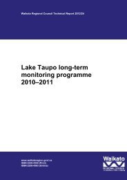
RanginuiEcological DistrictLocati<strong>on</strong> MapTokoroaEcological DistrictHorohoroRotorua LakesEcological DistrictWAIKATOREGIONAtiamuriEcological DistrictWaikite ValleyMaungakakaramea(Rainbow Mountain)PureoraEcological District0 125 250kmTirohanga RoadUpper Atiamuri WestWhangapoa SpringsWhakamaruWaipapa StreamPaerata RoadNgapouriMatapan RoadMaunga<strong>on</strong>ga<strong>on</strong>gaWaiotapu NorthNorthern Paeroa RangeWaiotapu SouthTe Kopia NorthwestMurphy's SpringsTe Kopia Red StreamTe Kopia West Mud PoolsL<strong>on</strong>gview RoadTe KopiaWharepapa RoadMangamingi Stati<strong>on</strong>WaihunuhunuAkatarewa EastAkatarewa StreamOrakeikorakoGolden SpringsRed HillsWhangairorohea<strong>Waikato</strong> River SpringsNgatamarikiOhaaki Steamfield WestOhaaki Steamfield EastTe Rautehuia StreamTe RautehuiaUpper Wairakei Stream (Geyser Valley)Lower Wairakei StreamWairakei BorefieldRotokawa NorthTe Kiri O Hine Kai Stream Catchment/Wairoa HillLake RotokawaWaipouwerawera Stream/TukairangiHall of Fame StreamKarapiti Forest Craters of the Mo<strong>on</strong>Otumuheke StreamSpa Thermal ParkBroadlands RoadCrown RoadWaipahihi ValleyCrown ParkKaingaroaEcological DistrictTaupoEcological DistrictHipauaTokaanu Thermal ParkTokaanu Urupa Mud PoolsTokaanu Tailrace CanalTokaanu Lake Shore WetlandMaunganamu North WetlandMaunganamu EastMaunganamu WestLegendKetetahiT<strong>on</strong>gariroEcological DistrictTe Maari CratersEmerald LakesRed CraterKaimanawaEcological DistrictGeothermal Sites and Significance LevelInternati<strong>on</strong>alInternati<strong>on</strong>al/Regi<strong>on</strong>al/LocalNati<strong>on</strong>alNati<strong>on</strong>al/LocalRegi<strong>on</strong>alRegi<strong>on</strong>al/LocalLocal<strong>Waikato</strong> Regi<strong>on</strong>al Council BoundaryEcological DistrictsData AcknowledgmentNZTopo250, Crown Copyright ReservedReport: 2348Client: WRCRef: 01 1212Path: E:\gis\EW_Geothermal_Sites_2003\2011\Report maps\File: Figure1. Locati<strong>on</strong> of geothermal sites.mxdFigure 1. Locati<strong>on</strong> and Ecological Significance ofGeothermal Sites in the <strong>Waikato</strong> Regi<strong>on</strong>0 7.515kmwww.wildlands.co.nz, 0508 WILDNZScale:Date:Cartographer:Format:© 20111:300,00026/07/11MRA3
This report includes an index of the geothermal sites, and the appendices includeinformati<strong>on</strong> <strong>on</strong> sites for which field work was undertaken, unranked sites, vegetati<strong>on</strong>codes, a glossary of technical terms including threatened and uncomm<strong>on</strong> plantcategories, and notes <strong>on</strong> the vascular flora of geothermal areas.A list of sites of geothermal surface expressi<strong>on</strong>s not known to comprise anysignificant geothermal vegetati<strong>on</strong>, found elsewhere in the <strong>Waikato</strong> Regi<strong>on</strong> arepresented in Appendix 3. These sites are all generally small and many have beenaltered for recreati<strong>on</strong>al use, such as swimming, or have been altered for farming orcommercial uses. Several are also <strong>on</strong> the sea margin in sand and c<strong>on</strong>tain novegetati<strong>on</strong>.Project Assignment<strong>Waikato</strong> Regi<strong>on</strong>al Council commissi<strong>on</strong>ed Wildland C<strong>on</strong>sultants to update the 2004Wildand C<strong>on</strong>sultants (Report No. 896) <strong>on</strong> geothermal vegetati<strong>on</strong> of the <strong>Waikato</strong>Regi<strong>on</strong> to the <strong>2007</strong> aerial photographs (WRAPs). This report incorporatesinformati<strong>on</strong> from a series of other reports undertaken for <strong>Waikato</strong> Regi<strong>on</strong>al Councilbetween 2004 and <strong>2007</strong> (Wildland C<strong>on</strong>sultants 2006, <strong>2007</strong>a and <strong>2007</strong>b). Informati<strong>on</strong>collected is compatible with the <strong>Waikato</strong> Regi<strong>on</strong>al Council biodiversity prioritisati<strong>on</strong>project.2. PREVIOUS WORKThe botany of many of the geothermal areas of the central North Island has beensurveyed, documented and assessed in numerous reports (see Bibliography).Rankings of the relative scientific or c<strong>on</strong>servati<strong>on</strong> significance of some sitesc<strong>on</strong>taining geothermal vegetati<strong>on</strong> and flora have been assigned in Given 1978 &1980a, Clarks<strong>on</strong> 1987a, and various other reports. Given (1989a & 1996) assessedthe relative botanical significance of geothermal sites in the Central Volcanic PlateauEcological Regi<strong>on</strong> within the <strong>Waikato</strong> Regi<strong>on</strong>.Merrett and Clarks<strong>on</strong> (1999) compiled an annotated bibliography of reports relevantto geothermal vegetati<strong>on</strong> occurring within the boundaries of the <strong>Waikato</strong> Regi<strong>on</strong>.Beadel and Bill (2000) and Wildland C<strong>on</strong>sultants (2004) provide important resources<strong>on</strong> which future reports have been based.This report is an updated and expanded report of Wildland C<strong>on</strong>sultants (2004),including additi<strong>on</strong>al sites updated and described in Wildland C<strong>on</strong>sultants 2006, <strong>2007</strong>aand <strong>2007</strong>b. Selected sites have been resurveyed and 13 sites not previously includedin this study have been included. Some site names have been changed <strong>on</strong> occasi<strong>on</strong> tobetter reflect <strong>Waikato</strong> Regi<strong>on</strong>al Council preferred place names (where a site name hasbeen changed, the site report has been annotated appropriately). Site numbers havealso been changed, as outlined above, and are now based <strong>on</strong> geothermal field. 2004site numbers are included in footnotes to allow cross referencing. The relativeecological significance of all sites has been re-evaluated.© 2011 4 C<strong>on</strong>tract Report No. 2348
3. METHODOLOGY3.1 Existing informati<strong>on</strong>Existing informati<strong>on</strong> <strong>on</strong> the distributi<strong>on</strong> and botany of geothermal areas in the<strong>Waikato</strong> Regi<strong>on</strong> was compiled from published and unpublished sources (seeBibliography). Geothermal sites c<strong>on</strong>taining, or likely to c<strong>on</strong>tain, geothermalvegetati<strong>on</strong> were identified from Cave et al. (1993), M<strong>on</strong>gillo and Clelland (1984),Leathwick et al. 1995, Given 1989a & 1995, Spring-Rice unpublished, Department ofC<strong>on</strong>servati<strong>on</strong> 1997, and pers<strong>on</strong>al knowledge. Department of C<strong>on</strong>servati<strong>on</strong> staffprovided some additi<strong>on</strong>al informati<strong>on</strong> <strong>on</strong> geothermal sites for this 2011 study.For each geothermal site, existing informati<strong>on</strong> was compiled for the followingcategories; grid references, site names, local authority, ecological district, geothermalfield (from Merrett and Clarks<strong>on</strong> 1999), bioclimatic z<strong>on</strong>e (from Leathwick et al.1995), tenure, altitude, notable indigenous flora, fauna, threats/modificati<strong>on</strong>/vulnerability, management requirements, significance/justificati<strong>on</strong>, and previousbotanical rank (from Given 1996), and Wildland C<strong>on</strong>sultants 2004, 2006, and<strong>2007</strong>a&b.3.2 Ecological districtsThree ecological districts in the <strong>Waikato</strong> Regi<strong>on</strong> c<strong>on</strong>tain sites with geothermalvegetati<strong>on</strong>. These are Atiamuri Ecological District, Taupo Ecological District (bothof which occur within the Central Volcanic Plateau Ecological Regi<strong>on</strong>) and T<strong>on</strong>gariroEcological District (within the T<strong>on</strong>gariro Ecological Regi<strong>on</strong>). 1 A tiny porti<strong>on</strong> ofMaungakakaramea occurs in the Rotorua Lakes Ecological District (
type of vegetati<strong>on</strong> present; indigenous flora (including the presence of any threatenedplants); fauna present (which included a literature review for each site); currentc<strong>on</strong>diti<strong>on</strong>; invasive exotic plants; human impacts; grazing; adjoining land use andmanagement requirements.The year of field survey for each site is provided in Appendix 2. Known geothermalsites that were not field surveyed are listed in Appendix 3.3.4 Geophysical propertiesGeophysical assessments have been undertaken for all or parts of 19 sites (listed inTable 1). Specific methods for these assessments varied slightly between thegeophysical c<strong>on</strong>sultants, but generally the following methods were used. Locati<strong>on</strong>sfor each feature were recorded using a GPS. Direct temperature measurements weremade with a thermocouple <strong>on</strong> a 4 4 m l<strong>on</strong>g wire, or a 100 100 mm l<strong>on</strong>g rigid probe,c<strong>on</strong>nected to a Fluke multimeter. If the surface to be measured was not accessible, aFluke IR thermometer was used, however this is subject to limitati<strong>on</strong>s, particularly ifsteam is present. The pH was measured with a Hanna Instruments pH meter with amaximum operating temperature of 50 C; if the spring temperature was > 50 C thewater was cooled to less than 50 C before the pH measurement was taken or a pHpaper strip was used. Further details are provided <strong>on</strong> each site sheet.Table 1:Sites and dates for which geophysical assessments were carried out. Theassessments are included in the site reports c<strong>on</strong>tained in Appendix 1.Site Number Site Name Date of AssessmentWAV02 Northern Paeora Range 29 & 30 June 2010WTV03 Waiotapu North 26 & 29 July 2010WTV05 Waiotapu South 27, 29 & 31 July 2010(about 1/3 of site)WTV04 Maungakakaramea (Rainbow Mountain) 26 July 2010(about 1/2 of site)MKV03 Tirohanga Road 5 February <strong>2007</strong>ATV01 Upper Atiamuri West 5 February <strong>2007</strong>ATV02 Whangapoa Springs 5 February <strong>2007</strong>TKV04 Te Kopia West Mud Pools 29 June 2010TKV05 Te Kopia Red Stream 29 June 2010TKV03 Te Kopia Northwest 29 June 2010TKV02 Murphy‟s Springs 29 June 2010TKV06 Mangamingi Stati<strong>on</strong> 28 June 2010OKV03 Orakeikorako 1 August 2010(about 1/2 of site)RPV02 Wharepapa Road 30 July 2010TOV10 Maunganamu East 7 February <strong>2007</strong>TOV07 Maunganamu West 13 February <strong>2007</strong>TOV14 Tokaanu Tailrace Canal 7 February <strong>2007</strong>TOV08 Tokaanu Thermal Park 7 February <strong>2007</strong>(about 1/2 of site)TOV09 Tokaanu Urupa Mud Pools 7 February <strong>2007</strong>6C<strong>on</strong>tract Report No. 2348
3.5 Vegetati<strong>on</strong> and habitat typesThe previous editi<strong>on</strong>s of this report (e.g. Wildland C<strong>on</strong>sultants 2004, <strong>2007</strong>a&b) basedvegetati<strong>on</strong> assessments <strong>on</strong> Merrett and Clarks<strong>on</strong> (1999), with some additi<strong>on</strong>al typesadded. This study bases its classificati<strong>on</strong> of geothermal vegetati<strong>on</strong> and habitat types<strong>on</strong> methods used in a similar study undertaken in the Bay of Plenty Regi<strong>on</strong>,specifically Wildland C<strong>on</strong>sultants (2005a&b). This was based <strong>on</strong> methodologyoutlined in Wildland C<strong>on</strong>sultants (2003) and Atkins<strong>on</strong> (1985). This report followsbroad types outlined in Wildland C<strong>on</strong>sultants <strong>2007</strong>b, as well as additi<strong>on</strong>al broad typesand structural types found during field survey for this report. These are listed belowin Table 2, by structural class and broad type.Table 2:List of geothermal vegetati<strong>on</strong> types and habitats. (Note this table includesvegetati<strong>on</strong> types identified in Wildland C<strong>on</strong>sultants (2004) and a study ofgeothermal vegetati<strong>on</strong> in the Bay of Plenty Regi<strong>on</strong> (Wildland C<strong>on</strong>sultants2005), not all of which occur in the <strong>Waikato</strong> Regi<strong>on</strong>.Vegetati<strong>on</strong>StructuralClassBroadVegetati<strong>on</strong>TypeDetailed Vegetati<strong>on</strong> Types and Habitats01 01 Pohutukawa-dominant forest01 Pohutukawa × northern rata-kamahi forest02 Pohutukawa × northern rata/mingimingi-prostrate kanuka forest03 Pohutukawa forest04 Pohutukawa-kanuka forest05 Pohutukawa × northern rata/prostrate kanuka-mingimingi forest01 02 Wattle forest01 Black wattle forest01 03 Treefern-dominant forest01 04 Kanuka-dominant forest01 Kanuka/mingimingi forest02 (Eucalyptus)/kanuka-Tasmanian blackwood/mingimingi forest03 Kanuka forest04 Kanuka-kohuhu/koromiko-blackberry forest05 Kanuka-radiata pine/manuka-mingimingi forest06 (Rewarewa)/kanuka forest.07 Eucalyptus/kanuka forest08 Kanuka-pohutukawa forest09 Kanuka-grey willow-crack willow-arrow bamboo/broom-blackberry forest10 Kanuka-rewarewa forest11 Kanuka forest kanuka shrubland01 05 Exotic pines forest01 Radiata pine/kanuka/mingimingi forest02 Macrocarpa/prostrate kanuka forest03 Maritime pine -false acacia forest04 Radiata pine/mingimingi forest05 Radiata pine forest06 Maritime pine-radiata pine/manuka-mingimingi forest01 06 Willow-dominant forest01 Grey willow/Schoenoplectus tabernaem<strong>on</strong>tani-raupo-swamp kiokio forest02 Grey willow/wheki forest03 Grey willow forest01 07 Kamahi-dominant forest01 Kamahi-pohutukawa/manuka forest02 Kamahi-kanuka-manuka forest01 08 Kahikatea-dominant forest01 Kahikatea forest01 09 Plantati<strong>on</strong>-mixed indigenous forest01 Tasmanian blackwood-manuka-kanuka-whauwhaupaku-kamahitikouka/blackberry-rank exotic grasses forest7C<strong>on</strong>tract Report No. 2348
Vegetati<strong>on</strong>StructuralClassBroadVegetati<strong>on</strong>TypeDetailed Vegetati<strong>on</strong> Types and Habitats02 01 Wattle treeland01 Silver wattle treeland02 Radiata pine-dominant treeland03 Pohutukawa-dominant treeland01 Pohutukawa/exotic grasses treeland04 Tree fern-dominant treeland05 Mixed exotic treeland01 Eucalyptus/mingimingi-manuka/mown lawn-n<strong>on</strong>vegetated raw-soilfieldtreeland02 (Alder)-(bamboo)/manuka-Histiopteris incisa treeland06 Silver birch-dominant treeland01 Silver birch/narrow-leaved carpet grass treeland07 Eucalyptus treeland01 Eucalyptus/n<strong>on</strong>vegetated raw-soilfield treeland08 Grey willow/mixed sedge treeland01 Grey willow/Baumea juncea-harakeke-Coprosma propinqua treelandmanuka-harakeke shrubland03 01 Japanese h<strong>on</strong>eysuckle-dominant vineland01 Japanese h<strong>on</strong>eysuckle-Paesia scaberula vineland02 Grape vine -dominant vineland01 Grape vineland03 Mixed exotic vineland01 Pohue-Japanese h<strong>on</strong>eysuckle-blackberry vineland04 01 Prostrate kanuka-dominant scrub01 Prostrate kanuka scrub02 Prostrate kanuka-mingimingi scrub03 Prostrate kanuka-mingimingi-manuka scrub04 (Pohutukawa)/prostrate kanuka scrub05 Prostrate kanuka-manuka-mingimingi scrub06 (Dead pohutukawa x northern rata)/prostrate kanuka-mingimingi scrub07 Tasmanian blackwood/prostrate kanuka scrub08 Exotic pine/prostrate kanuka scrub09 Manuka/prostrate kanuka scrub10 Prostrate kanuka-manuka-Chinese privet scrub11 Maritime pine/prostrate kanuka-blackberry scrub02 Mingimingi-dominant scrub01 Mingimingi-manuka scrub02 Mingimingi-manuka-kanuka scrub03 Mingimingi-prostrate kanuka-manuka scrub Histiopteris incisafernland Hypolepis distans fernland gorse scrub.04 Mingimingi-kanuka scrub05 Mingimingi-kanuka-prostrate kanuka scrub06 Mingimingi-bracken-manuka scrub07 Dead pohutukawa × northern rata/manuka-mingimingi scrub08 (Dead pohutukawa × northern rata)-(wheki)/mingimingi-Histiopteris incisa-Gahnia setifolia-gorse scrub09 Black wattle/mingimingi-manuka scrub10 Mingimingi-Histiopteris incisa shrubland11 Mingimingi scrub manuka scrub12 Mingimingi scrub13 Exotic pine/mingimingi scrub14 (Radiata pine)/mingimingi-prostrate kanuka scrub15 Mingimingi-kanuka-manuka-karamu/bracken scrub16 Mingimingi-manuka-prostrate kanuka scrub12 Tasmanian blackwood/mingimingi scrub13 Mingimingi-manuka-blackberry-indigenous broadleaved species scrub14 Mingimingi-blackberry-manuka-prostrate kanuka scrub03 Manuka-dominant scrub01 Manuka scrub02 Manuka-mingimingi scrub03 Eucalyptus/manuka-mingimingi scrub04 Manuka-kanuka/mingimingi scrub8C<strong>on</strong>tract Report No. 2348
Vegetati<strong>on</strong>StructuralClassBroadVegetati<strong>on</strong>TypeDetailed Vegetati<strong>on</strong> Types and Habitats05 (Grey willow)-(ti kouka)/manuka scrub06 Black wattle/manuka scrub07 Grey willow/manuka scrub08 Manuka mingimingi-broom scrub09 Manuka-Spanish heath scrub10 Manuka-kanuka-Spanish heath scrub11 Manuka-prostrate kanuka scrub12 Manuka-mingimingi scrub prostrate kanuka shrubland13 Exotic pine/manuka-mingimingi scrub14 Manuka-mingimingi scrub exotic pine/karamu-wheki-mamaku scrub15 (Scattered radiata pines)/manuka-mingimingi scrub16 Manuka-mingimingi scrub radiata pine-maritime pine/karamu-whekimamakuscrub17 Manuka-prostrate kanuka-Chinese privet scrub18 Manuka-mingimingi-blackberry-bracken scrub04 Kanuka-dominant scrub01 Kanuka scrub02 Kanuka/mingimingi scrub03 Kanuka-mahoe scrub04 Kanuka/prostrate kanuka scrub05 Eucalyptus/manuka mingimingi scrub06 Kanuka-kohuhu/koromiko-blackberry scrub07 (Silver birch)/kanuka-mingimingi scrub08 Kanuka/narrow-leaved carpet grass scrub09 Kanuka-pohutukawa-black wattle scrub05 Indigenous mixed shrubs-dominant communities01 Mingimingi-manuka-blackberry-indigenous broadleaved species scrub02 Whauwhaupaku scrub03 Whauwhaupaku-kanuka/mingimingi scrub06 Gorse-dominant scrub01 Gorse scrub07 Exotic and indigenous plantings scrub08 Blackberry-dominant scrub01 Blackberry scrub02 Blackberry-Himalayan h<strong>on</strong>eysuckle-pohue scrub03 Silver birch-Chinese privet/blackberry scrub04 (Silver birch)/blackberry-manuka-prostrate kanuka scrub05 (Silver birch)/blackberry-prostrate kanuka scrub09 Exotic-dominant scrub01 Barberry/blackberry scrub02 Radiata pine-maritime pine/broom-manuka-mingimingi scrub10 Buddleia-dominant scrub01 Buddleia scrub11 Chinese privet-dominant scrub01 Chinese privet scrub12 M<strong>on</strong>oao-dominant scrub01 M<strong>on</strong>oao scrub05 01 Prostrate kanuka-dominant shrubland01 Prostrate kanuka shrubland02 Prostrate kanuka-mingimingi shrubland03 (Kanuka)/prostrate kanuka-mingimingi-Carex secta shrubland04 (Kanuka)/prostrate kanuka-rank grasses shrubland05 Prostrate kanuka-manuka-bracken shrubland06 Prostrate kanuka-mingimingi-m<strong>on</strong>oao-toru shrubland07 Prostrate kanuka/narrow-leaved carpet grass shrubland08 Prostrate kanuka-manuka shrubland09 Prostrate kanuka-Hypolepis ambigua shrubland10 Prostrate kanuka/sweet vernal shrubland11 Prostrate kanuka/n<strong>on</strong>vegetated raw-soilfield12 Wilding pine/prostrate kanuka-mingimingi shrubland13 Prostrate kanuka-broom-blackberry shrubland14 Wilding pine/prostrate kanuka shrubland9C<strong>on</strong>tract Report No. 2348
Vegetati<strong>on</strong>StructuralClassBroadVegetati<strong>on</strong> Detailed Vegetati<strong>on</strong> Types and HabitatsType15 Prostrate kanuka-mingimingi-manuka shrubland16 Prostrate kanuka/ exotic grass shrubland17 Wilding pine/prostrate kanuka-mingimingi shrubland18 Wilding pine/prostrate kanuka-mingimingi-manuka shrubland19 Prostrate kanuka-kamahi-wheki-whauwhaupaku/blackberry shrubland02 Mingimingi-dominant shrubland01 Mingimingi-Histiopteris incisa-bracken shrubland02 Mingimingi-manuka shrubland03 Mingimingi-prostrate kanuka shrubland04 Mingimingi-Hypolepis distans-turutu shrubland Hypolepis distansturutu-brackenfernland prostrate kanuka scrub05 Exotic pine/mingimingi-prostrate kanuka shrubland06 Mingimingi shrubland03 Manuka-dominant shrubland01 Manuka shrubland02 Manuka-(kamahi) shrubland03 (Emergent mixed exotic trees)/manuka-kanuka-mixed exotic speciesshrubland04 Manuka-mingimingi shrubland05 Manuka-kanuka-mingimingi shrubland06 Manuka-prostrate kanuka shrubland07 Manuka/bracken shrubland08 Manuka/narrow-leaved carpet grass shrubland09 (Silver birch)/manuka/Cyperus ustulatus-Hypolepis distans shrubland10 Manuka-prostrate kanuka/Lycopodiella cernua shrubland11 Manuka/gorse-creeping bent/n<strong>on</strong>vegetated raw-soilfield shrubland12 Manuka-kanuka/Histiopteris incisa shrubland13 (Manuka)-(m<strong>on</strong>oao)-(Gaultheria paniculata)-(prostrate kanuka)/Racomitrium sanuginosum shrubland14 Manuka/Baumea rubiginosa shrubland15 Manuka-wheki/Histiopteris incisa-Hypolepis ambigua shrubland16 Manuka-mingimingi-m<strong>on</strong>oao shrubland17 Manuka/Spanish heath-exotic grasses shrubland18 Manuka-mingimingi-Histiopteris incisa-bracken shrubland19 Manuka-mingimingi-broom shrubland20 Manuka shrubland↔raupo-Carex secta-Cyperus ustulatus reedland21 Manuka-harakeke shrubland22 Manuka-pampas shrubland23 Black wattle/manuka-blackberry-bracken shrubland24 Manuka/bracken-broom shrubland ↔broom-bracken-blackberryshrubland↔prostrate kanuka scrub25 (Maritime pine)/manuka-broom-blackberry-Himalayan h<strong>on</strong>eysuckleshrubland26 Manuka-harakeke-Cyperus ustulatus shrubland27 Manuka/Histiopteris incisa-Carex secta shrubland28 Maritime pine/manuka-pampas shrubland29 Manuka-prostrate kanuka-mingimingi shrubland04 Kanuka-dominant shrubland01 Kanuka-mingimingi shrubland02 (Kanuka)/prostrate kanuka-rank grasses shrubland03 Kanuka/Mercer grass shrubland04 Kanuka-mingimingi-bracken shrubland05 Kanuka/Mercer grass-narrow-leaved carpet grass shrubland06 Kanuka shrubland07 Kanuka-manuka/oioi shrubland08 Wilding pine/prostrate kanuka shrubland09 Wilding pine/kanuka-mingimingi-manuka shrubland05 Pohutukawa-dominant shrubland01 Pohutukawa shrubland06 Gorse-dominant shrubland01 Gorse shrubland10C<strong>on</strong>tract Report No. 2348
Vegetati<strong>on</strong>StructuralClassBroadVegetati<strong>on</strong>TypeDetailed Vegetati<strong>on</strong> Types and Habitats07 Planted indigenous shrubland01 Panted indigenous shrubland and manuka-mingimingi shrubland02 (Harakeke)-(kohuhu) shrubland/n<strong>on</strong>vegetated ground08 Mixed indigenous shrubland01 Kanuka/prostrate kanuka-blackberry-mingimingi-Carex virgata shrubland02 Rewarewa-kamahi-(toru)/prostrate kanuka-m<strong>on</strong>oao shrubland03 Mixed indigenous shrubs/mixed fern species shrubland04 (Maritime pine)/kiokio-blackberry-bracken-buddleia shrubland09 Exotic planted shrubland01 Cultivar manuka-mingimingi-flowering cherry-red hot poker-harakeke (andother garden plants) shrubland.10 Mixed indigenous-exotic shrubland01 (Mingimingi)-(arrow bamboo)-(manuka)-(broom)-(silver birch)/narrowleavedcarpet grass-Mercer grass/raw-soilfield shrubland02 (Wheki-kohuhu-tī kouka)/wheki-kiokio-blackberry shrubland11 Mixed-exotic shrubland01 Gorse-blackberry/Yorkshire fog-Hypolepis ambigua-Histiopteris incisashrubland12 M<strong>on</strong>oao dominant shrubland01 M<strong>on</strong>oao-manuka-prostrate kanuka-mingimingi shrubland13 Blackberry-dominant shrubland01 (Grey willow)/blackberry-Carex geminata shrubland02 Exotic pine/blackberry-prostrate kanuka shrubland03 (Indigenous species)/blackberry-bracken-kiokio shrubland04 Blackberry (dead) shrubland05 Blackberry-broom/Yorkshire fog shrubland06 Blackberry- Cyclosorus interruptus shrubland07 Blackberry shrubland08 Blackberry-mingimingi-Nephrolepis flexuosa shrubland14 Ti kouka-dominant shrubland01 Ti kouka-kanuka shrubland15 M<strong>on</strong>oao dominant shrubland01 M<strong>on</strong>oao-manuka-prostrate kanuka-mingimingi shrubland06 01 Pampas tussockland02 Mixed pampas tussockland07 01 Dicranopteris-dominant fernland01 Dicranopteris linearis fernland02 Dicranopteris linearis-narrow-leaved carpet grass fernland02 Hypolepis dicks<strong>on</strong>ioides-dominant fernland03 Bracken-dominant fernland01 Bracken fernland02 Wheki/bracken fernland03 Bracken-Japanese h<strong>on</strong>eysuckle-Himalayan h<strong>on</strong>eysuckle fernland04 (Dead manuka)bracken-mingimingi-gorse fernland05 Bracken-mingimingi-blackberry fernland04 Histiopteris incisa-dominant fernland01 Histiopteris incisa fernland02 Histiopteris incisa-narrow-leaved carpet grass-gorse fernland03 Histiopteris incisa-mingimingi fernland05 Mixed fernland01 Histiopteris incisa-bracken-mingimingi fernland02 Dead manuka/bracken-turutu-Histiopteris incisa-mingimingi fernland03 Histiopteris incisa-bracken-mingimingi-Mercer grass-Yorkshire fogfernland04 Histiopteris incisa-mingimingi-bracken fernland05 Hypolepis ambigua-Histiopteris incisa fernland06 Dicranopteris linearis- Christella aff. dentata ("thermal”)-Nephrolepisflexuosa fernland07 Histiopteris incisa-gorse-Hypolepis ambigua-Carex virgata fernland08 Bracken-kiokio-blackberry-wheki-Paesia scaberula fernland09 Histiopteris incisa-Cyperus ustulatus fernland10 Paesia scaberula-exotic grasses fernland11C<strong>on</strong>tract Report No. 2348
Vegetati<strong>on</strong>StructuralClassBroadVegetati<strong>on</strong>TypeDetailed Vegetati<strong>on</strong> Types and Habitats11 Histiopteris incisa-bracken-wheki fernland12 Hypolepis distans-Gleichenia microphylla-Hypolepis ambigua fernland13 Bracken- Cyclosorus interruptus-blackberry-pampas/n<strong>on</strong>vegetated rawsoilfieldfernland14 Dicranopteris linearis-Histiopteris incisa fernland15 Mixed fernland16 Manuka-(makomako)/Hypolepis ambigua fernland17 Bracken-Baumea rubiginosa-mixed fern sedgeland06 Christella aff. dentata ("thermal”)-dominant fernland01 Christella aff. dentata ("thermal”)-fernland02 Christella aff. dentata ("thermal”)-blackberry-rank exotic grasses fernland03 Christella aff. dentata ("thermal”)-Nephrolepis flexuosa-blackberryfernland07 Lycopodiella-dominant fernland01 Lycopodiella cernua fernland08 Nephrolepis flexuosa-dominant fernland01 Nephrolepis flexuosa fernland02 Nephrolepis flexuosa-Dicranopteris linearis fernland03 Nephrolepis flexuosa-bracken-Christella aff. dentata ("thermal”)-blackberry fernland09 Hypolepis ambigua-dominant fernland01 Hypolepis ambigua-Histiopteris incisa fernland10 Nephrolepis cordifolia-dominant fernland01 Nephrolepis cordifolia fernland11 Paesia scaberula-dominant fernland01 Paesia scaberula fernland12 Deparia-dominant fernland01 Deparia fernland13 Cheilanthes-dominant fernland01 Cheilanthes sieberi-Mercer grass fernland02 Cheilanthes sieberi-buffalo grass fernland14 Cyclosorus-dominant fernland01 Cyclosorus interruptus fernland08 01 Yorkshire fog-dominant grassland01 Yorkshire fog grassland02 Prostrate kanuka/Yorkshire fog grassland03 Manuka/Yorkshire fog grassland02 Narrow-leaved carpet grass-dominant grassland01 Narrow-leaved carpet grassland02 Mosaic of narrow-leaved carpet grassland, manuka-mingimingi shrubland,and n<strong>on</strong>vegetated raw-soilfield03 Narrow-leaved carpet grass-exotic garden plants grassland04 (Manuka)-(prostrate kanuka)/narrow-leaved carpet grassland05 Narrow-leaved carpet grass-wild serradella grassland03 Creeping bent grassland04 Mercer grass-dominant grassland01 Mercer grass-Paesia scaberula grassland02 Mercer grass-narrow-leaved carpet grassland03 Mercer grass grassland04 Mercer grass-Cyclosorus interruptus-Hypolepis ambigua grassland05 Kikuyu grassland06 Mixed exotic-dominant grassland01 Mercer grass-creeping bent-Microlaena stipoides grassland.02 Sweet vernal-browntop grassland03 Mown and rank exotic grassland04 (Prostrate kanuka)/rank exotic grasses grassland05 (Baumea antrhrophylla)/mixed exotic grasses-raw-soilfield grassland07 Indian doab-dominant grassland01 Indian doab grassland08 Reed sweet grass-dominant grassland01 Reed sweet grassland02 Reed sweet grass-raupo-Schoenoplectus tabernaem<strong>on</strong>tani grassland12C<strong>on</strong>tract Report No. 2348
Vegetati<strong>on</strong>StructuralClassBroadVegetati<strong>on</strong>TypeDetailed Vegetati<strong>on</strong> Types and Habitats03 Raupo/reed sweetgrass- Schoenoplectus tabernaem<strong>on</strong>tani-swamp milletgrassland09 01 Carex geminata-dominant sedgeland01 Carex geminata sedgeland02 Cyperus ustulatus-dominant sedgeland01 Cyperus ustulatus sedgeland02 Cyperus ustulatus-Cortaderia fulvida-Juncus edgarae-Histiopteris incisasedgeland03 Cyperus ustulatus-Cortaderia fulvida-blackberry sedgeland04 Dead kanuka/Cyperus ustulatus-pampas sedgeland05 Wheki-p<strong>on</strong>ga/Cyperus ustulatus-Cyclosorus interruptus sedgeland06 Cyperus ustulatus-raupo sedgeland03 Carex virgata-dominant sedgeland01 Carex virgata-Nephrolepis flexuosa sedgeland02 Gorse-Carex virgata-Cyperus ustulatus sedgeland04 Baumea rubiginosa-dominant sedgeland01 Baumea rubiginosa sedgeland02 Wheki/Baumea rubiginosa-kiokio sedgeland05 Mixed sedgeland01 Carex virgata-Carex secta-Cyperus ustulatus-Baumea articulatasedgeland02 Grey willow/Carex secta-raupo-Schoenoplectus tabernaem<strong>on</strong>tanisedgeland06 Carex secta-dominant sedgeland01 Carex secta-raupo sedgeland02 (Kanuka)/Carex secta sedgeland07 Isolepis distigmatosa-dominant sedgeland01 Isolepis distigmatosa sedgeland08 Oioi-dominant sedgeland01 Oioi sedgeland10 01 Juncus prismatocarpus-dominant rushland01 Juncus prismatocarpus-Carex geminata rushland11 01 Raupo-dominant reedland01 Raupo reedland02 (Ti kouka)-(grey willow)/raupo-harakeke-manuka/Juncus effusus-Isolepisdistigmatosa reedland03 Raupo-Cyperus ustulatus reedland04 (Grey willow)-raupo-Carex secta-Schoenoplectus tabernaem<strong>on</strong>tanireedland raupo-pohuehue-Schoenoplectus tabernaem<strong>on</strong>tani reedland05 (Grey willow)-raupo-Schoenoplectus tabernaem<strong>on</strong>tani-Carex sectareedland06 Raupo-Schoenoplectus tabernaem<strong>on</strong>tani-Carex secta reedland07 (Alder)/raupo reedland08 Raupo-Schoenoplectus tabernaem<strong>on</strong>tani-Japanese h<strong>on</strong>eysucklereedland09 Raupo/Carex virgata reedland10 (Grey willow)-(silver birch)-(ti kouka)/raupo-blackberry reedland11 Raupo-blackberry reedland12 Raupo-Schoenoplectus tabernaem<strong>on</strong>tani-Carex secta-Baumea rubiginosareedland13 (Crack willow)/raupo reedland14 (Ti kouka)-(manuka)/raupo-Cyperus ustulatus-Schoenoplectustabernaem<strong>on</strong>tani reedland15 Grey willow/raupo reedland16 Raupo-harakeke reedland Carex secta-Baumea rubiginosa-Baumeajuncea sedgeland02 Baumea articulata-dominant reedland01 Baumea articulata reedland03 Baumea arthrophylla-dominant sedgeland01 Baumea arthrophylla sedgeland04 Mixed Baumea sedgeland13C<strong>on</strong>tract Report No. 2348
Vegetati<strong>on</strong>StructuralClassBroadVegetati<strong>on</strong>TypeDetailed Vegetati<strong>on</strong> Types and Habitats06 Baumea rubiginosa-dominant sedgeland01 (Manuka)-(wheki)/Baumea rubiginosa sedgeland12 Cushi<strong>on</strong>field13 01 Herbfield01 Polyg<strong>on</strong>um maculosa herbfield02 Arrow grass herbfield14 01 Racomitrium-dominant Mossfield01 Racomitrium sanuginosum mossfield02 Campylopus-dominant mossfield01 Campylopus capillaceous mossfield02 Campylopus sp. mossfield15 Lichenfield16 Rockland17 01 (Sparse vegetati<strong>on</strong>)/boulderfield01 (Prostrate kanuka)/boulderfield18 St<strong>on</strong>efield/gravelfield19 Sandfield01 Geothermally heated sandfield20 Loamfield/Peatlfield21 Flaxland22 01 Geothermal water01 Geothermal water02 Mud pools03 Geothermal sands and hot springs04 Geothermal springs, mud pools, geothermal stream and sinter.23 01 Wheki-dominant treefernland01 Wheki/gorse-Histiopteris incisa treefernland02 (Dead pohutukawa × northern rata)/wheki-Gahnia setifolia treefernland03 (Dead pohutukawa × northern rata)/wheki-kamahi treefernland04 Wheki treefernland24 Mudfield25 Cliffland26 Turf27 Algalfield28 01 N<strong>on</strong>vegetated raw-soilfield01 N<strong>on</strong>vegetated raw-soilfield02 N<strong>on</strong>vegetated raw-soilfield (mining operati<strong>on</strong>s)03 Geothermal sand04 N<strong>on</strong>vegetated raw-soil field (geothermal and landslide debris)05 Bare ground06 Prostrate kanuka/n<strong>on</strong>vegetated raw-soilfield shrubland02 (Prostrate kanuka)/raw-soilfield01 (Prostrate kanuka)/n<strong>on</strong>vegetated raw-soilfield03 (Sparse indigenous vegetati<strong>on</strong>)/raw-soilfield01 (Kanuka)-(pohutukawa)-(mingimingi)-(silver birch)/ n<strong>on</strong>vegetated rawsoilfield02 (Pohutukawa)-(manuka)-(Mercer grass)/ n<strong>on</strong>vegetated raw-soilfield03 (Manuka)-(Cyperus ustulatus)/ n<strong>on</strong>vegetated raw-soilfield04 (Prostrate kanuka)-(manuka)/ n<strong>on</strong>vegetated raw-soilfield05 (Manuka)/ n<strong>on</strong>vegetated raw-soilfield06 (Juncus edgarae)-(Carex virgata)-(Morelotia affinis)-(mixed exotic grasses)/n<strong>on</strong>vegetated raw-soilfield07 (Cyperus ustulatus)-(kanuka)-(Cortaderia fulvida)/n<strong>on</strong>vegetated raw-soilfield04 Exotic grasses/ n<strong>on</strong>vegetated raw-soilfield01 Dead kikuyu-dead narrow-leaved carpet grass/ n<strong>on</strong>vegetated rawsoilfield.29 01 Residential development-scattered geothermal vegetati<strong>on</strong>01 Residential development-scattered geothermal vegetati<strong>on</strong>30 01 Bamboo-dominant bambooland01 Arrow bambooland14C<strong>on</strong>tract Report No. 2348
3.6 Threats/modificati<strong>on</strong>/vulnerabilityFor each site, current threats, modificati<strong>on</strong> and vulnerability were evaluated underfour categories:invasive exotic plant specieshuman threatsgrazingadjoining land useInvasive exotic plant species were assessed in terms of their abundance. A coverclass index based <strong>on</strong> Allen (1992) (see Table 3) was used to indicate the relativeabundance of weeds at each site.Table 3: Cover class index (from Allen 1992).3.7 Site mappingPercentage CoverCover Class
assessments. The sites were grouped into four categories (A-D), where 'A' is thehighest rank and 'D' is the lowest. These are listed in the notes secti<strong>on</strong> for each site.3.10 Ecological evaluati<strong>on</strong>The relative significance of each geothermal site (see Figure 1) was assessed as part ofthe current study using the criteria specified in Envir<strong>on</strong>ment <strong>Waikato</strong> Regi<strong>on</strong>al PolicyStatement (2002). This has recently been updated to reflect more recent changes tothe New Zealand Threat Classificati<strong>on</strong> Lists (refer to Appendices 10 and 11). Usingthese criteria, each site was assigned to <strong>on</strong>e of four levels of relative significance:Internati<strong>on</strong>ally Significant, Nati<strong>on</strong>ally Significant, Regi<strong>on</strong>ally Significant, or LocallySignificant. The rankings were completed in the pre-formatted Excel spreadsheetprovided by the Council.3.11 Data analysis dataData was generated from analyses of mapped vegetati<strong>on</strong> for each site. The extent ofeach geothermal vegetati<strong>on</strong> type (as per Table 2) in each site was calculated. Theextent of geothermal vegetati<strong>on</strong> in each ecological district, geothermal field, and ineach administrative district was also calculated (see Tables 5, 9, 10, and 11). Thesetotals exclude geothermal water. A total is given for geothermal water, and terrestrialand emergent geothermal wetland habitats, at each site.Vegetati<strong>on</strong> mosaics have been included in the site descripti<strong>on</strong>s and accompanyingmaps for more accurate descripti<strong>on</strong>s, however for GIS data compilati<strong>on</strong>, the mosaicswere assigned to the vegetati<strong>on</strong> type dominant in a mosaic, thereby providing a scaleappropriate for analysis at a regi<strong>on</strong>al level.3.12 Presentati<strong>on</strong> of resultsGeothermal FieldsSite informati<strong>on</strong> is presented in order of geothermal field, generally following a Northto South alignment, and then a West to East alignment.The following informati<strong>on</strong> is presented for each geothermal field within the <strong>Waikato</strong>Regi<strong>on</strong>.1. A list of geothermal sites within the <strong>Waikato</strong> Regi<strong>on</strong>.2. A separate data sheet for each geothermal site (see Table 4 below).3. MapsTopographic maps showing the locati<strong>on</strong> of each geothermal site (scale1:20,000).Vegetati<strong>on</strong> maps of sites overlain <strong>on</strong> aerial photographs (vegetati<strong>on</strong> mapscales vary from 1:2,000 to 1:15,000 depending <strong>on</strong> the size of the site).4. All geothermal sites are listed in Table 5, within relevant geothermal fieldsand ecological districts. The area (ha) of geothermal vegetati<strong>on</strong> at each siteand the significance ranking assigned to the site are provided in Table 6 (seeSecti<strong>on</strong> 5).16C<strong>on</strong>tract Report No. 2348
Table 4:Format and categories for presentati<strong>on</strong> of informati<strong>on</strong> <strong>on</strong>geothermal sites.Site Number:Grid Reference:GPS Reference:Local Authority:Ecological District:Geothermal Field:Bioclimatic Z<strong>on</strong>e:Tenure:Altitude:Extent of Geothermal Habitat:Extent of Geothermal Vegetati<strong>on</strong>:Date of Field Survey:SITE NAMECode Type Landform ExtentGeophysical Assessment: 1Indigenous Flora:Fauna:Current C<strong>on</strong>diti<strong>on</strong> (Year of Most Recent Assessment):Threats/Modificati<strong>on</strong>/ Vulnerability:Invasive pest plants (Year of most recent Assessment):Human impacts (Year of most recent Assessment):Grazing (Year of most recent Assessment):Adjoining land use (Year of most recent Assessment):Site Change:Recent Change:Historical:Management Requirements:Significance Level:Significance Justificati<strong>on</strong>:Notes:References:1Selected sites <strong>on</strong>ly.17C<strong>on</strong>tract Report No. 2348
Explanatory Notes for the Site Summary SheetExplanatory notes for the site summary sheet are provided below:Site Number: Number assigned to a site during the current survey. These have allbeen updated since the Wildland C<strong>on</strong>sultants (2004) report, and previous site numbersare provided in a footnote for cross reference.Grid Reference: Central grid reference of the site from the relevant NZTopo50topographic map. The 2004 to <strong>2007</strong> reports were based <strong>on</strong> NZMS260, which are nol<strong>on</strong>ger being used.GPS Reference: The grid reference is also provided as a GPS reference in NZTM(New Zealand Transverse Mercator).Local Authority: Local authority with jurisdicti<strong>on</strong> over the area.Ecological District: Ecological district within which the site lies. Ecological districtseach have distinctive characteristics of climate, geology, landform, soils andbiological features (Myers et al. 1987). Three ecological districts in the <strong>Waikato</strong>Regi<strong>on</strong> c<strong>on</strong>tain sites with geothermal vegetati<strong>on</strong>.Geothermal Field: Name of the geothermal field within which the site lies.Geothermal surface features are supplied with mineralised hot water or steam fromunderlying geothermal resevoirs, and <strong>on</strong>e field may supply many discrete geothermalsites. Geothermal field names and the assignment of each site to a geothermal fieldwere undertaken by the <strong>Waikato</strong> Regi<strong>on</strong>al Council.Bioclimatic Z<strong>on</strong>e: Bioclimatic z<strong>on</strong>es follow Leathwick et al. (1995), and are definedin Appendix 5.Tenure: Tenure is shown as either protected or unprotected private land, or both ifapplicable. If the area is protected, the type of protecti<strong>on</strong> (e.g. reserve, covenant) isshown.Altitude: Altitude of the site given in metres, determined from topographical maps.For larger sites a range is given.Extent of Geothermal Habitat: Total area of geothermal habitat. This includesgeothermal water and geothermal vegetati<strong>on</strong> in hectares (see geothermal vegetati<strong>on</strong>below).Extent of Geothermal Vegetati<strong>on</strong>: Total area of geothermal vegetati<strong>on</strong> (see Table 2).This excludes geothermal water, but includes n<strong>on</strong>vegetated raw-soilfield in hectares.Date of Field Survey: Date of the most recent field survey.18C<strong>on</strong>tract Report No. 2348
Vegetati<strong>on</strong> Code: A numeric code based <strong>on</strong> structural class, broad vegetati<strong>on</strong> type,and detailed vegetati<strong>on</strong> type following Wildland C<strong>on</strong>sultants (2005) C<strong>on</strong>tractReports 1056 and 1072, and additi<strong>on</strong>al types included in Table 2.Vegetati<strong>on</strong> Type: A vegetati<strong>on</strong> classificati<strong>on</strong> using predefined structural classes and aprotocol for assigning type names based <strong>on</strong> the dominant plant species, as describedin Atkins<strong>on</strong> (1985), Wildland C<strong>on</strong>sultants C<strong>on</strong>tract Report No. 757, and additi<strong>on</strong>altypes observed during the current field survey (see Table 2).Landform: Describes the physical landform <strong>on</strong> which a vegetati<strong>on</strong> type occurs.Geophysical Assessment: Describes the unique geothermal physical aspects of thesite (note that this assessment has <strong>on</strong>ly been carried out <strong>on</strong> selected sites and at somelarger sites, <strong>on</strong>ly parts of the geophysical aspects were assessed).Indigenous Flora: <str<strong>on</strong>g>An</str<strong>on</strong>g>y species characteristic of geothermal sites, and nati<strong>on</strong>allythreatened or uncomm<strong>on</strong> species (as per de Lange et al. 2009) are listed. Relevantinformati<strong>on</strong> may also be provided about plant distributi<strong>on</strong> (for more detail refer toAppendix 4).Fauna: A list of fauna known to occur at the site. Previous reports focussed <strong>on</strong>indigenous species <strong>on</strong>ly, but all fauna informati<strong>on</strong> has been included in this reportwhere possible. A literature review was undertaken for each site, although for mostsites, no further informati<strong>on</strong> was found.Current C<strong>on</strong>diti<strong>on</strong>: Comments <strong>on</strong> the overall current c<strong>on</strong>diti<strong>on</strong> of the site asdetermined from field rec<strong>on</strong>naissance and existing informati<strong>on</strong>. May includecomment <strong>on</strong> features related to the character and history of the site which haveinfluenced vegetati<strong>on</strong> compositi<strong>on</strong>.Threats/Modificati<strong>on</strong>/Vulnerability: <str<strong>on</strong>g>An</str<strong>on</strong>g>y current or potential threats to the indigenousvegetati<strong>on</strong> and integrity of the geothermal ecosystem, particularly the occurrence andabundance of invasive exotic plants, potential and current human threats, and threatsfrom domestic stock or pest animals, and adjoining landuse.Site Change Recent Change: <str<strong>on</strong>g>An</str<strong>on</strong>g>y changes to the site since the last field visit (andgeneral comments about change in the last ten years) were noted, and any changesevident in the <strong>2007</strong> aerial photographs compared with recent earlier surveys. Changesthat are not a real change, but simply a result of better quality aerial photographs werenoted.Site Change Historical: Historical changes determined from 1940s to 1960s aerialphotographs and relevant literature. <strong>Aerial</strong> photograph codes recorded as follows, forexample a site with the code SN 172 Run 1176 Photos 5-6, 1946: SN = survey runnumber, Run = flight path number, Photos = number of photo(s) into the flight path,1946 = year of photograph.Management Requirements: Recommendati<strong>on</strong>s for acti<strong>on</strong> necessary to prevent,minimise or remedy any known threats or modificati<strong>on</strong> to the site.19C<strong>on</strong>tract Report No. 2348
Significance Level: The significance level assigned to the site from the ecologicalevaluati<strong>on</strong> criteria based <strong>on</strong> <strong>Waikato</strong> Regi<strong>on</strong>al Council Technical Report TR2002/15(Envir<strong>on</strong>ment <strong>Waikato</strong> and Wildland C<strong>on</strong>sultants 2002). Areas of SignificantIndigenous Vegetati<strong>on</strong> and Habitats of Indigenous Fauna in the <strong>Waikato</strong> Regi<strong>on</strong>:Guidelines to apply Regi<strong>on</strong>al Criteria and Determine Level of Significance (refer toAppendix 11).Significance/Justificati<strong>on</strong>:particularsignificance level.A brief explanati<strong>on</strong> of why a site was assigned to aNotes: <str<strong>on</strong>g>An</str<strong>on</strong>g>y further comments including and previous rankings of geothermalvegetati<strong>on</strong> (e.g. Given 1995).References: References which are of direct relevance to the site.<str<strong>on</strong>g>An</str<strong>on</strong>g> index by site and page number has been prepared to make informati<strong>on</strong> in thisreport more readily accessible (presented at the end of the report).Locati<strong>on</strong> MapFigure 1 (scale c.1:300,000) shows the locati<strong>on</strong> of each geothermal site with itssignificance level(s).20C<strong>on</strong>tract Report No. 2348
Table 5:Breakdown of broad geothermal hydroclass and vegetati<strong>on</strong> groups within each site ordered by geothermal field and ranked by areaof geothermal vegetati<strong>on</strong>, <strong>Waikato</strong> Regi<strong>on</strong>.Site NameSiteNumberEcologicalDistrictGeothermalWater(ha)Hydroclass/Vegetati<strong>on</strong> GroupingGeothermal Vegetati<strong>on</strong>N<strong>on</strong>vegetatedRaw-Soilfield(ha)TerrestrialVegetati<strong>on</strong>(ha)EmergentWetland(ha)TotalGeothermalVegetati<strong>on</strong>(ha)Total Site Area(GeothermalVegetati<strong>on</strong> andGeothermalWater)(ha)Horohoro Geothermal FieldHorohoro HHV01 Atiamuri
Site NameSiteNumberEcologicalDistrictGeothermalWater(ha)Hydroclass/Vegetati<strong>on</strong> GroupingGeothermal Vegetati<strong>on</strong>N<strong>on</strong>vegetatedRaw-Soilfield(ha)TerrestrialVegetati<strong>on</strong>(ha)EmergentWetland(ha)TotalGeothermalVegetati<strong>on</strong>(ha)Total Site Area(GeothermalVegetati<strong>on</strong> andGeothermalWater)(ha)Mangamingi Stati<strong>on</strong> TKV06 Atiamuri 0.1 0.4 0.5 0.5Total 1.1 5.6 49.8 4.4 59.8 60.9Orakeikorako Geothermal FieldWaihunuhunu OKV01 Atiamuri 2.3 0.3 2.7 3.0 5.3Akatarewa Stream OKV02 Atiamuri 1.4 1.4 1.4Orakeikorako OKV03 Atiamuri
Site NameSiteNumberEcologicalDistrictGeothermalWater(ha)Hydroclass/Vegetati<strong>on</strong> GroupingGeothermal Vegetati<strong>on</strong>N<strong>on</strong>vegetatedRaw-Soilfield(ha)TerrestrialVegetati<strong>on</strong>(ha)EmergentWetland(ha)TotalGeothermalVegetati<strong>on</strong>(ha)Total Site Area(GeothermalVegetati<strong>on</strong> andGeothermalWater)(ha)(Geyser Valley)Wairakei Borefield WKV04 Atiamuri
4. DEFINITION OF GEOTHERMALLY INFLUENCED VEGETATIONGeothermally influenced terrestrial and emergent wetland vegetati<strong>on</strong>are plant communities that have compositi<strong>on</strong>al, structural, and/orgrowth rate characteristics determined by current or former inputs ofgeothermally-derived energy (heat) or material (solid, fluid, or gas).Merrett & Clarks<strong>on</strong> 1999Compositi<strong>on</strong>al, structural, and/or growth rate characteristics of geothermallyinfluenced terrestrial and emergent wetland vegetati<strong>on</strong> include the unexpectedpresence of species found elsewhere in warmer climates or at lower altitudes orlatitudes (disjunct populati<strong>on</strong>s), prostrate or stunted growth forms, and reducedgrowth rates. Merrett & Clarks<strong>on</strong> (1999) classified geothermal habitats into fourbroad categories:heated groundgeothermal wetlandscooled hydrothermally altered soilsatmospheric influence from regular toxic gas emissi<strong>on</strong>s, or warm micro-climatescreated by hot-springs discharge.Refer to Appendix 6 for explanati<strong>on</strong>s of these terms. This was accompanied by ahierarchical classificati<strong>on</strong> of geothermally influenced terrestrial and emergent wetlandvegetati<strong>on</strong>, of which detailed vegetati<strong>on</strong> types and habitats are included in site reports.4.1 Basis of summarising extent of geothermal habitat, geothermal vegetati<strong>on</strong>,and open waterThe broad summaries of geothermal vegetati<strong>on</strong> and habitats in this report include allmapped geothermal habitat that includes vegetati<strong>on</strong> dominated by vascular plants,n<strong>on</strong>-vascular plants, n<strong>on</strong>vegetated raw-soilfield (which often c<strong>on</strong>tain scattered patchesof n<strong>on</strong>-vascular and vascular plants), and emergent wetland vegetati<strong>on</strong>. It does notinclude open geothermal water. Geothermal water was mapped if it was an integralpart of a geothermal site. Open water is included in “extent of geothermal habitat” insite reports, but not in “extent of geothermal vegetati<strong>on</strong>”.4.2 Geothermal wetland vegetati<strong>on</strong>Adapted from Wildland C<strong>on</strong>sultant 2005 (Report No. 1072).The definiti<strong>on</strong> of geothermal wetland for this study follows Clarks<strong>on</strong> et al. (2002) andJohns<strong>on</strong> (2004).“A wetland hydrosystem where the dominant functi<strong>on</strong> is geothermally heated water.The RMA91 specifies geothermal waters as those heated by natural phenomena to30 degrees C or above. Geothermal wetlands may have water temperatures belowthis, but must be c<strong>on</strong>sidered geothermal due to the chemical compositi<strong>on</strong> of the water.Geothermal wetlands are permanently or intermittently wet areas, shallow water, orland water margins that support a natural ecosystem of plants that have compositi<strong>on</strong>al,© 201024C<strong>on</strong>tract Report No. 2348
structural, and/or growth rate characteristics determined by current or former inputs ofgeothermally derived water.” (Clarks<strong>on</strong> et al. 1992)“A hydrosystem where volcanic activity produces hot surface waters, or heated soils(30 o C or more) or where geothermal chemistry affects wetland habitats.” (Johns<strong>on</strong>2004)Wetlands habitats have been mapped as best as possible within limitati<strong>on</strong>s of time,difficulty of safe access and issues of very small scales. Many wetland vegetati<strong>on</strong>types cover a very small area and are too small to be mapped.Examples where limitati<strong>on</strong>s of a single site visit approach and scale of mapping existsto determine geothermal wetland boundaries include:heated wet air (steam) from fumaroles and hot pools can extend for either smalldistances, or quite c<strong>on</strong>siderable distances from the surface geothermal activity,and are generally difficult to map.heated water flowing over waterfalls produces graduati<strong>on</strong>s of habitats affected bywater flow, splash, spray (Johns<strong>on</strong> 2004) and through seepages and associatedincreased air and soil temperatures providing habitat for plant species typical ofgeothermal activity.the presence of surface geothermal activity can fluctuate at a particular locati<strong>on</strong>and across a landscape.Access to all parts of a geothermally active area is difficult in some locati<strong>on</strong>s,particularly in geothermal wetlands where isolated geothermal seepages andimmediate geothermal plants can be surrounded by cold water species (e.g. raupo(Typha orientalis) wetland). In this situati<strong>on</strong> the vegetati<strong>on</strong> is mapped as <strong>on</strong>e broadclass. Generally the water present will have geothermal derived chemical inputs.Wetlands are quite varied both within and between geothermal sites, for example atWaiotapu South, there are extensive areas of wetland manuka (Leptospermumscoparium) scrub, with additi<strong>on</strong>al areas of raupo reedland, and Baumea junceasedgeland, while at Te Kopia Wetland areas are dominated by Baumea rubiginosa. Inthe Tokaanu Lakeshore Wetland, there are extensive areas of raupo reedland, withsmall areas of oioi (Apodasmia similis) rushland present at Tokaanu Thermal Park.Geothermal wetlands provide habitat for threatened fern species such as Thelypterisc<strong>on</strong>fluens at Waikite and Cyclosorus interruptus at Waiotapu South.4.3 N<strong>on</strong>vegetated raw-soilfield (Source: Merrett & Clarks<strong>on</strong> 1999)Areas that are bare of vegetati<strong>on</strong> that are (i) too hot to support plant life, (ii) arecooled but hydrothermally altered, sinter pavements, or (iii) are subjected to regularmud ejecti<strong>on</strong> or gas emissi<strong>on</strong> that prevent col<strong>on</strong>isati<strong>on</strong> and established plants. Theseareas are often small scale, and may not be visible <strong>on</strong> aerial photographs.Very hot soils are often associated with steam vents and/or boiling mud craters, andsoil temperatures at 10 cm depth are usually >90 o C.© 201025C<strong>on</strong>tract Report No. 2348
Vigorously boiling mud pools and craters that regularly eject hot mud around marginseffectively prevent plant col<strong>on</strong>isati<strong>on</strong>. Where toxic gas is emitted, vegetati<strong>on</strong> is eitherabsent, or if present, killed.Hydrothermally altered soils often occur where geothermal expressi<strong>on</strong> has ceased,e.g. dried mud craters, which result in soils with unusual chemical compositi<strong>on</strong>.4.3.1 Basis of mapping of n<strong>on</strong>vegetated raw-soilfield for this studyThis study is based <strong>on</strong> both field survey and interpretati<strong>on</strong> of vegetati<strong>on</strong> cover based<strong>on</strong> aerial photographs. At many sites, particularly large <strong>on</strong>es, not all units ofvegetati<strong>on</strong> and habitats could be viewed in the field, nor was it safe to do so.Occasi<strong>on</strong>al scattered vascular and n<strong>on</strong>-vascular plants are included in mapping,particularly in areas that appear as bare ground <strong>on</strong> aerial photographs, and in areasthat could not be viewed by field survey. On this basis, n<strong>on</strong>vegetated raw-soilfield isincluded in tallies of terrestrial geothermal vegetati<strong>on</strong> in the summary of vegetati<strong>on</strong>types by geothermal field.Large areas with open water and abundant mud pools were mapped as opengeothermal water, while small mud pools am<strong>on</strong>gst n<strong>on</strong>vegetated raw-soilfield havebeen mapped as n<strong>on</strong>vegetated raw-soilfield. Open water areas c<strong>on</strong>taining abundantmud pools were given a separate vegetati<strong>on</strong> code (22.01.02).5. GEOTHERMAL SITES IN THE WAIKATO REGIONA total of 64 sites have been described in Appendix 1 and are listed in Table 5. The<strong>on</strong>ly known major excepti<strong>on</strong> is the hill slopes above Tokaanu, which are likely toc<strong>on</strong>tain some sites with significant examples of geothermal vegetati<strong>on</strong>. Landownerpemissi<strong>on</strong> was not received to enable survey of these sites, so these sites were notsurveyed or mapped. While these sites are c<strong>on</strong>sidered to be relatively small, fieldsurvey of them should be a high priority if access can be arranged. Details of thevegetati<strong>on</strong>, c<strong>on</strong>diti<strong>on</strong>, and significance of each site are presented in Appendix 1,together with vegetati<strong>on</strong> type maps <strong>on</strong> an aerial photograph backdrop, andtopographic maps showing site boundaries. Each of the 64 sites meets <strong>on</strong>e or more ofthe criteria for ecological significance in the <strong>Waikato</strong> Regi<strong>on</strong>al Policy Statement(refer to Appendix 10). Therefore, each site was assigned a relative significancelevel; Internati<strong>on</strong>al, Nati<strong>on</strong>al, Regi<strong>on</strong>al, or Local following the assessment method inAppendix 11. Four sites were identified as being of Internati<strong>on</strong>al significance(Te Kopia, Te Maari Craters, Emerald Lakes and Red Crater) and part of another site(Waiotapu South), encompassing c.205 ha or 24% of geothermal habitat in the<strong>Waikato</strong> Regi<strong>on</strong> (see Table 6). Eight sites were of Nati<strong>on</strong>al significance, with twosites being partly of Nati<strong>on</strong>al significance and partly of Local significance,encompassing c.382 ha or 46% of geothermal habitat in the <strong>Waikato</strong> Regi<strong>on</strong>.Twenty-three sites were identified as being of Regi<strong>on</strong>al significance, with anadditi<strong>on</strong>al two sites being partly of Regi<strong>on</strong>al and partly of Local significance. Parts ofWaiotapu South were identified as being of Internati<strong>on</strong>al, Regi<strong>on</strong>al and Localsignificance. In total, c.242 ha or 29% of geothermal habitat in the <strong>Waikato</strong> Regi<strong>on</strong>was identified as being Regi<strong>on</strong>ally significant. The remainder of the sites (25) were© 201026C<strong>on</strong>tract Report No. 2348
Site Name(Site Number)EcologicalDistrictArea (ha) of Site According toEcological Significance RankingInternati<strong>on</strong>al Nati<strong>on</strong>al Regi<strong>on</strong>al LocalNgatamariki Geothermal Field<strong>Waikato</strong> River Springs Atiamuri 0.6(NMV01)Ngatamariki (NMV02) Atiamuri 1.7Total 2.3Whangairorohea Geothermal FieldWhangairorohea(WGV01)Atiamuri
Site Name(Site Number)EcologicalDistrictArea (ha) of Site According toEcological Significance RankingInternati<strong>on</strong>al Nati<strong>on</strong>al Regi<strong>on</strong>al LocalMaunganamu West Taupo/ T<strong>on</strong>gariro 0.6(TOV07)Tokaanu Thermal Park T<strong>on</strong>gariro/ Taupo 7.8
Table 7: Geothermal sites for which the level of significance has been revisedbetween <strong>2007</strong> and 2011.SiteNo.Site NameAssessments ofRelative SignificancePreviousAssessment(2004-<strong>2007</strong>)2011AssessmentReas<strong>on</strong> for Change ofSignificance RankingMKV03 Tirohanga Road Regi<strong>on</strong>al Local <str<strong>on</strong>g>An</str<strong>on</strong>g> „At Risk‟ species, prostrate kanuka(Kunzea ericoides var. microflora), ispresent, but the populati<strong>on</strong> is small.A number of sites have larger areasof vegetati<strong>on</strong> dominated by thisspecies.MKV04 Paerata Road Regi<strong>on</strong>al (part)Local (part)Local<str<strong>on</strong>g>An</str<strong>on</strong>g> „At Risk‟ species, prostratekanuka, is present, but the site is notan important habitat for thec<strong>on</strong>servati<strong>on</strong> of this species.OKV02 AkatarewaStreamNati<strong>on</strong>al Regi<strong>on</strong>al Reclassificati<strong>on</strong>* of the threat statusof Christella aff. dentata (“thermal”).NMV02 Ngatamariki Nati<strong>on</strong>al (part)Regi<strong>on</strong>al (part)Regi<strong>on</strong>al Reclassificati<strong>on</strong>* of the threat statusof Cyclosorus interruptus.RKV02 Lake Rotokawa Regi<strong>on</strong>al Nati<strong>on</strong>al <str<strong>on</strong>g>Based</str<strong>on</strong>g> <strong>on</strong> <strong>on</strong>going improvements tothe c<strong>on</strong>diti<strong>on</strong> of the site, size, the widediversity of geothermal habitatspresent, and the presence of a largeand important populati<strong>on</strong> ofCalochilus roberts<strong>on</strong>ii, an „At Risk‟species.NMV01 <strong>Waikato</strong> RiverSpringsNati<strong>on</strong>al Regi<strong>on</strong>al Reclassificati<strong>on</strong>* of the threat statusof Christella aff. dentata (“thermal”).THV05 Crown Park Regi<strong>on</strong>al Local <str<strong>on</strong>g>An</str<strong>on</strong>g> „At Risk‟ species, prostratekanuka, is present, but the populati<strong>on</strong>is small. A number of sites havelarger areas of vegetati<strong>on</strong> dominatedby this species.WKV04WairakeiBorefieldRegi<strong>on</strong>al Local <str<strong>on</strong>g>An</str<strong>on</strong>g> „At Risk‟ species, prostratekanuka, is present, but the populati<strong>on</strong>is small. A number of sites havelarger areas of vegetati<strong>on</strong> dominatedby this species.WKV06 Lower WairakeiStreamNati<strong>on</strong>al Regi<strong>on</strong>al Reclassificati<strong>on</strong>* of the threat statusof Christella aff. dentata (“thermal”).WKV07 Karapiti Forest Regi<strong>on</strong>al Local <str<strong>on</strong>g>An</str<strong>on</strong>g> „At Risk‟ species, prostratekanuka, is present, but the populati<strong>on</strong>is small. A number of sites havelarger areas of vegetati<strong>on</strong> dominatedby this species.* In 2009, the threat classificati<strong>on</strong> of the New Zealand‟s vascular flora was revised and updated(de Lange et al. 2009). The ranking for many species was revised including several species present ingeothermal areas: Cyclosorus interruptus, Christella aff. dentata (“thermal”) and prostrate kanuka wererevised from „Chr<strong>on</strong>ically Threatened‟ (de Lange et al. 2004) to „At Risk‟ (de Lange et al. 2009).These revised rankings resulted in the significance level for some sites being revised downward. SeeAppendix 4 for details of 2009 threat rankings for plant species typical of geothermal areas.© 201030C<strong>on</strong>tract Report No. 2348
6. GEOTHERMAL VEGETATION OF THE WAIKATO REGION - ANOVERVIEWA total of c.734 ha of geothermal vegetati<strong>on</strong> (including raw-soilfield) was mapped inthe <strong>Waikato</strong> Regi<strong>on</strong> in this study, with an additi<strong>on</strong>al 106 ha of open water mapped.This is an increase of c.21% to the area mapped in Wildland C<strong>on</strong>sultants (2004),where c.579 ha was mapped. The increase reflects an increase to the scope of theproject rather than a real increase in the extent of geothermal vegetati<strong>on</strong> and habitats.This is discussed in full in Secti<strong>on</strong> 8 below. Most of this change can be accounted forby the additi<strong>on</strong> of existing sites to this project in Wildland C<strong>on</strong>sultants 2006, <strong>2007</strong>a,<strong>2007</strong>b, and the current study. Additi<strong>on</strong>al parts of sites were also found, most notablyat Waiotapu South where additi<strong>on</strong>al areas of geothermal wetland were found.6.1 Assessment by geothermal fieldHorohoro Geothermal FieldThe geothermal features of this field (an overflowing pool and a seepage) is mappedin this report as <strong>on</strong>e site; Horohoro (HHV01). The site is currently surrounded bypasture, and values could be enhanced if the site were fenced to exclude stock.Species typical of geothermal habitat recorded in 2004 were Lycopodiella cernua,mingimingi (Leucopog<strong>on</strong> fasciculatus), and Gleichenia microphylla. Nephrolepisflexuosa has been recorded from this site in the past (Given 1995), but is presumedextinct at this site (Bycroft and Beadel <strong>2007</strong>). This field has
Surface water draw-off to supply a public swimming pool is the <strong>on</strong>ly extractive use ofthe geothermal resource. Extensive areas to the north of the Waikite Swimming Bathsare farmed, and areas that were previously wetlands have been drained for farmingpurposes. Vegetati<strong>on</strong> al<strong>on</strong>g most stream margins, and geothermal wetlands has beensubjected to grazing by both cattle and stock in the past. Most of the wetlands arenow fenced to exclude stock. Work is underway to restore a large geothermalwetland in the part of the site that is <strong>on</strong> the Waikite Landcorp Farm. The streambelow the Corbett Road Bridge is dominated by weed species, and the geothermalareas <strong>on</strong> the Waikite Scarp are surrounded by dense areas of blackberry (Rubusfruticosus agg.) scrub. The site c<strong>on</strong>tains important habitat for a number of „At Risk‟plant species including the sec<strong>on</strong>d largest populati<strong>on</strong> of Christella aff. dentata(“thermal”) in New Zealand. Five other „At Risk‟ species (as per de Lange et al.2009) are known from this site; prostrate kanuka, Cyclosorus interruptus, Thelypterisc<strong>on</strong>fluens, Nephrolepis flexuosa, Dicranopteris linearis, and Hypolepis dicks<strong>on</strong>ioides.The Waikite Geothermal Field is classified as a „Protected Geothermal System‟ by<strong>Waikato</strong> Regi<strong>on</strong>al Council 1 .Waiotapu Geothermal FieldThe Waiotapu Geothermal Field c<strong>on</strong>tains the largest area of surface geothermalactivity in New Zealand (Cave et al. 1993). The vegetati<strong>on</strong> of this field is mappedover five sites, although the boundaries of these sites are somewhat arbitrary, withgeothermal vegetati<strong>on</strong> being almost c<strong>on</strong>tinuous between these five sites. A total ofc.221.0 ha of geothermal vegetati<strong>on</strong> was mapped, which comprises almost a third(c.30.1%) of the geothermal vegetati<strong>on</strong> of the <strong>Waikato</strong> Regi<strong>on</strong>. As the sites arecurrently mapped, Waiotapu South is the largest of the sites in this field comprisingc.112.4 ha of geothermal vegetati<strong>on</strong>, followed by Maungakakaramea (RainbowMountain) (c.50.6 ha), Waiotapu North (c.45.8 ha), Maunga<strong>on</strong>ga<strong>on</strong>ga (c.9.06 ha), andNgapouri (c.3.1 ha). Most or all of Maungakakaramea (Rainbow Mountain),Maunga<strong>on</strong>ga<strong>on</strong>ga, and Waiotapu South are protected and administered by theDepartment of C<strong>on</strong>servati<strong>on</strong>. A small part of Ngapouri Stati<strong>on</strong> is also protected as aCovenant. Other sites and parts of these sites are in private ownership and aresurrounded by farmland and plantati<strong>on</strong> forests.The area mapped in the Waiotapu Geothermal Field comprises 176.7 ha of terrestrialvegetati<strong>on</strong>, c.18.0 ha of n<strong>on</strong>vegetated raw-soilfield, and c.26.3 ha of geothermalwetland. All of the area mapped as geothermal wetland was in the southern part ofthe geothermal field in part of the area mapped as Waiotapu South. This is the bestgeothermal wetland vegetati<strong>on</strong> in the <strong>Waikato</strong> Regi<strong>on</strong> with the wetland extendingbey<strong>on</strong>d the area mapped into n<strong>on</strong>-geothermal wetland. The geothermal porti<strong>on</strong> of thiswetland comprises c.32.4% of the geothermal wetland vegetati<strong>on</strong> of the <strong>Waikato</strong>Regi<strong>on</strong>. While the wetlands present at Tokaanu are larger, they do not c<strong>on</strong>tain thediversity of habitat types, or the diversity of geothermal features of the Orutu Wetlandat Waiotapu. The areas mapped as n<strong>on</strong>vegetated raw-soilfield (c.18% of this type inthe <strong>Waikato</strong> Regi<strong>on</strong>) include some of the largest area of sinter terraces remaining in1http://www.waikatoregi<strong>on</strong>.govt.nz/envir<strong>on</strong>mental-informati<strong>on</strong>/Geothermal-resources/Classifyinggeothermal-systems:Accessed 24 July 2011.© 201032C<strong>on</strong>tract Report No. 2348
New Zealand, as well as extensive areas of geothermally heated bare ground. The sitec<strong>on</strong>tains c.176.3 ha (c.31.4%) of the terrestrial geothermal vegetati<strong>on</strong> in the <strong>Waikato</strong>Regi<strong>on</strong>. The field includes c.198.6 ha of indigenous geothermal scrub and shrubland(which includes some extensive areas of geothermal wetland mapped as manukascrub). Of this, 146.94 ha is dominated by prostrate kanuka scrub and shrubland(38.7% of the area dominated by this species in the <strong>Waikato</strong> Regi<strong>on</strong>), making this themost important field for this species and vegetati<strong>on</strong> type in the <strong>Waikato</strong> Regi<strong>on</strong>.Taxa present in this geothermal field classed as „At Risk‟ in de Lange et al. (2009) areprostrate kanuka, Cyclosorus interruptus, Schizaea dichotoma (sparse), Nephrolepisflexuosa, Dicranopteris linearis, Calochilus paludosus, C. roberts<strong>on</strong>ii, Petalochilusalatus, Stegostyla atradenia, and Korthalsella salicornioides. The populati<strong>on</strong> ofCyclosorus interruptus in Orutu Wetland is the largest populati<strong>on</strong> of this speciespresent at any geothermal site in New Zealand. Other species of interest areLycopodiella cernua, S. fistulosa and S. bifida, Psilotum nudum, Caladenia atradenia,Thelymitra carnea, T. decora, and T. ixioides.This geothermal field, particularly the parts protected in Scenic Reserves atMaunga<strong>on</strong>ga<strong>on</strong>ga, Maungakakaramea (Rainbow Mountains), and the Waiotapu Southsite c<strong>on</strong>tains the greatest area of habitat of any geothermal field in New Zealand.Management of pest plants, particularly wilding pines is a priority in protected areas,and some c<strong>on</strong>trol of these species has been undertaken by land managers and theDepartment of C<strong>on</strong>servati<strong>on</strong> recently. Extensive damage by pigs through tramplingand making tracks thoughout the geothermal wetland vegetati<strong>on</strong> was observed in theOrutu Wetland of Waiotapu South during the current study. The WaiotapuGeothermal Field is classified as a „Protected Geothermal System‟ by <strong>Waikato</strong>Regi<strong>on</strong>al Council 1 .Parts of the geothermal vegetati<strong>on</strong> and habitats that are not protected are subject tograzing and extensive areas are dominated by pest plants. These unprotected areas areimportant linkages between the protected areas of geothermal habitat, and regularmanagement of pest plants, particularly wilding trees should be undertaken. Theseareas should be regularly m<strong>on</strong>itored for management issues and formal protecti<strong>on</strong> anda restorati<strong>on</strong> plan for these areas would enhance and/or protect the highly significantecological values of this field.Mangakino Geothermal FieldAt least <strong>on</strong>e boiling spring was known at Mangakino but was drowned during theformati<strong>on</strong> of Lake Maraetai (Cave et al. 1993) and is not included in the currentstudy. No terrestrial geothermal vegetati<strong>on</strong> is known to be present within thisgeothermal field. The Mangakino Geothermal Field is classified as a „DevelopmentGeothermal System‟ by <strong>Waikato</strong> Regi<strong>on</strong>al Council 1 .1http://www.waikatoregi<strong>on</strong>.govt.nz/envir<strong>on</strong>mental-informati<strong>on</strong>/Geothermal-resources/Classifyinggeothermal-systems:Accessed 24 July 2011.© 201033C<strong>on</strong>tract Report No. 2348
Mokai Geothermal FieldFour sites within the Mokai Geothermal Field were described in this study. Thesecomprise small areas of steam-heated activity and a small area (c.2.9 ha) of associatedgeothermal vegetati<strong>on</strong>. This is c.0.4% of the geothermal vegetati<strong>on</strong> in the <strong>Waikato</strong>Regi<strong>on</strong>. <str<strong>on</strong>g>An</str<strong>on</strong>g> additi<strong>on</strong>al area of c.0.4 ha was mapped as geothermal water. Thenorthern part of the Waipapa Stream site includes the third largest populati<strong>on</strong> of thefern, Christella aff. dentata (“thermal”) (ranked as At Risk-Declining in de Langeet al. 2009) in New Zealand. Prostrate kanuka (another „At Risk‟ species) wasrecorded from Paerata Road and Tirohanga Road. Other plants characteristic ofgeothermal sites include Psilotum nudum which is uncomm<strong>on</strong> in the <strong>Waikato</strong> Regi<strong>on</strong>,(formally an „at risk‟ species classed as „RRange Restricted‟ in de Lange et al. 2004,but now no l<strong>on</strong>ger c<strong>on</strong>sidered threatened), Doodia australis, Lycopodiella cernua, andCampylopus capillaceus.A geothermal power plant began producing electricity at the Mokai Geothermal Fieldby drawing off geothermal fluid in November 1999 and now generates 96 MW(http://www.mightyriverpower.co.nz/Generati<strong>on</strong>/AboutUs/Geothermal/Mokai.aspxaccessed 4 July 2011). All geothermal fluid is being re-injected 4 km from the site(Stretch 2000 in Merrett & Fitzgerald 2004). M<strong>on</strong>itoring is recommended to assessthe impacts of energy extracti<strong>on</strong> <strong>on</strong> geothermal features in this field. This field isclassified as a „Development Geothermal System‟ by <strong>Waikato</strong> Regi<strong>on</strong>al Council 1 .Other key management issues include:Some geothermal features at Paerata Road are grazed by stock, and values wouldbe enhanced by fencing. Fences should be checked regularly at Tirohanga Roadto ensure stock are excluded from the site.Wildling pines are an issue at Waipapa Stream. Future plantati<strong>on</strong> pine planting atthe site should allow a buffer between the plantati<strong>on</strong> and geothermal features, andany wilding trees should be regularly removed from the site.Atiamuri Geothermal FieldSeveral hot springs and pools occur at the Whangapoa Springs and the Matapan RoadGeothermal sites, and several other surface expressi<strong>on</strong>s of geothermal activity arepresent at Upper Atiamuri West. There is evidence from past records that the area<strong>on</strong>ce had hotter temperatures (Cave et al. 1993), and two pools are known to havebeen submerged by Lake Atiamuri. There are similarities between the Atiamuri andHorohoro Geothermal Fields and the two fields may be c<strong>on</strong>nected (Cave et al. 1993).A small populati<strong>on</strong> of Nephrolepis flexuosa is present by <strong>on</strong>e hot pool at WhangapoaSprings. This and the neighbouring pool at Whangapoa Springs have been fenced,and c<strong>on</strong>siderable weed c<strong>on</strong>trol and planting of indigenous tree species has taken placeat this site since the 2004 study. The other two sites are within farmland, or in fencedgullies adjacent to farmland, with no significant ecological values found. This field1http://www.waikatoregi<strong>on</strong>.govt.nz/envir<strong>on</strong>mental-informati<strong>on</strong>/Geothermal-resources/Classifyinggeothermal-systems:Accessed 24 July 2011.© 201034C<strong>on</strong>tract Report No. 2348
c<strong>on</strong>tains c.0.1 ha of geothermal vegetati<strong>on</strong> and is classified as a „LimitedDevelopment Geothermal System‟ by <strong>Waikato</strong> Regi<strong>on</strong>al Council 1 .Te Kopia Geothermal FieldGeothermal vegetati<strong>on</strong> at Te Kopia Geothermal Field (c.59.21 ha) comprises c.8.2%of the geothermal vegetati<strong>on</strong> of <strong>Waikato</strong> Regi<strong>on</strong>, which is the fifth largest area ofgeothermal vegetati<strong>on</strong> within a geothermal field in the <strong>Waikato</strong> Regi<strong>on</strong>. Thisvegetati<strong>on</strong> has been mapped over six geothermal sites, with most of the vegetati<strong>on</strong>being present at Te Kopia (TKV01); c.58.8 ha. Most of this site is within theTe Kopia Scenic Reserve and is surrounded by a large area of indigenous vegetati<strong>on</strong>;mainly forest within the Te Kopia Scenic Reserve. The geothermal vegetati<strong>on</strong> ofTe Kopia (TKV01) is in good c<strong>on</strong>diti<strong>on</strong>, and this site was identified as being ofInternati<strong>on</strong>al significance. The geothermal activity of this area is thought to resultfrom steam boiling off deep chloride water. All the features result from steamheating, although chloride springs are thought to have occurred here in the past (Caveet al. 1993).The vegetati<strong>on</strong> at Te Kopia Geothermal Field is made up of 49.8 ha of terrestrialgeothermal vegetati<strong>on</strong>, c.5.6 ha of n<strong>on</strong>vegetated raw-soilfield, and c.4.4 ha ofemergent wetland. <str<strong>on</strong>g>An</str<strong>on</strong>g> additi<strong>on</strong>al <strong>on</strong>e hectare was mapped as geothermal water. Thefield has c.5% of the geothermal wetland and 8.8% of the geothermal terrestrialvegetati<strong>on</strong> in the <strong>Waikato</strong> Regi<strong>on</strong>. Approximately 44 ha was mapped as indigenousscrub or shrubland, and c.20.5 ha of this was mapped as prostrate kanuka scrub andshrubland, which is about 5% of the total area of prostrate kanuka in the <strong>Waikato</strong>Regi<strong>on</strong>.This site c<strong>on</strong>tains very high quality examples of geothermal vegetati<strong>on</strong>. One of thelargest populati<strong>on</strong>s in New Zealand of the fern Dicranopteris linearis (classed as „AtRisk‟ in de Lange et al. 2009) occurs here. D. linearis is known from c.24 sites inNew Zealand. Murphy‟s Springs c<strong>on</strong>tains a good sized populati<strong>on</strong> of Christella aff.dentata (“thermal”) (also classed as „At Risk‟) with about 100 plants present. Other„At Risk‟ species known from this field include Schizaea dichotoma, Calochiluspaludosus, C. roberts<strong>on</strong>ii, Korthalsella salicornioides, and Nephrolepis flexuosa.Key management issues in Te Kopia Geothermal Field include fencing of geothermalhabitat where stock may have access to „At Risk‟ fern populati<strong>on</strong>s outside Te KopiaScenic Reserve (e.g. Mangamingi Stati<strong>on</strong> and Murphy‟s Springs). Pest plants shouldc<strong>on</strong>tinue to be m<strong>on</strong>itored and c<strong>on</strong>trolled in Te Kopia Scenic Reserve, particularlywilding pines. Formal protecti<strong>on</strong> (e.g. Covenant) should be c<strong>on</strong>sidered forgeothermal areas outside of the Te Kopia Scenic Reserve. The Te Kopia GeothermalField is classified as a „Protected Geothermal System‟ by <strong>Waikato</strong> Regi<strong>on</strong>al Council 1 .Orakeikorako Geothermal FieldGeothermal vegetati<strong>on</strong> at Orakeikorako Geothermal Field (c.58.2 ha) comprisesc.7.9% of the geothermal vegetati<strong>on</strong> of <strong>Waikato</strong> Regi<strong>on</strong>, and is the sixth largest area1http://www.waikatoregi<strong>on</strong>.govt.nz/envir<strong>on</strong>mental-informati<strong>on</strong>/Geothermal-resources/Classifyinggeothermal-systems:Accessed 24 July 2011.© 201035C<strong>on</strong>tract Report No. 2348
of geothermal vegetati<strong>on</strong> in the <strong>Waikato</strong> Regi<strong>on</strong>. <str<strong>on</strong>g>An</str<strong>on</strong>g> additi<strong>on</strong>al 2.5 ha was mapped asgeothermal water. The vegetati<strong>on</strong> has been mapped over five sites with the largestareas of geothermal vegetati<strong>on</strong> present at two sites; Orakeikorako (c.42.4 ha) and RedHills (c.11.4 ha). This includes c.2.3 ha of n<strong>on</strong>vegetated raw-soilfield, c.2.7 ha ofwetland, and the remainder as terrestrial geothermal vegetati<strong>on</strong>. In this field, a totalof c.52.6 ha of vegetati<strong>on</strong> has been mapped as indigenous scrub and shrubland, withc.10.4 ha being mapped as scrub and shrubland dominated by prostrate kanuka - thisis about 2.7% of the prostate kanuka dominated vegetati<strong>on</strong> in the <strong>Waikato</strong> Regi<strong>on</strong>.Present day geothermal features and vegetati<strong>on</strong> represent <strong>on</strong>ly part of what was <strong>on</strong>ce aspectacular geyser field (Cave et al. 1993). About three quarters of the geothermalfeatures were lost when the <strong>Waikato</strong> River was dammed and Lake Ohakuri wascreated in 1961 (Cave et al. 1993). Cave et al. (1993) note that any development forexploitati<strong>on</strong> of the Te Kopia and Ngatamariki fields would need to be investigated toestablish the nature and extent of possible c<strong>on</strong>necti<strong>on</strong>s with Orakeikorako. Te Kopiais classed as a „Protected Geothermal Systems‟ by <strong>Waikato</strong> Regi<strong>on</strong>al Council 1 .Ngatamariki is a „Development Geothermal System‟ and Mighty River Power hasc<strong>on</strong>sent to develop it, however early warning m<strong>on</strong>itoring wells are being drilledbetween Ngatamariki and Orakeikorako which will be m<strong>on</strong>itored for pressure changeswith protocols to ensure there is no effect <strong>on</strong> Orakeikorako (K. Luketina pers.comm.)..The two largest sites in the Orakeikorako Geothermal Field, Red Hills andOrakeikorako, c<strong>on</strong>tain large areas of good quality geothermal vegetati<strong>on</strong>, arenati<strong>on</strong>ally significant sites, and are notable for a large populati<strong>on</strong> of the „At Risk‟fern, Dicranopteris linearis (classed as „At Risk‟ in de Lange et al. 2009). As well asD. linearis, there are a relatively high number of other at risk species including goodpopulati<strong>on</strong>s of several at risk ferns; Christella aff. dentata („thermal), Schizaeadichotoma, Nephrolepis flexuosa, Thelypteris c<strong>on</strong>fluens, and Cyclosorus interruptus;and the orchids Calochilus roberts<strong>on</strong>ii and Prasophyllum pumilum (Given 1989).Other notable geothermal species present, include Lycopodiella cernua, arrow grass(Triglochin striata), Schizea bifida, sea rush (Juncus kraussii var. australiensis),Psilotum nudum, and the moss Campylopus capillaceus.The key management issue in this field is the management of pest plants, particularlywilding pines, Chinese privet (Ligustrum sinense), and black wattle (Acacia mearnsii).Blackberry should be c<strong>on</strong>trolled where present in the eastern side of Lake Whakamaruwhere it is currently rare. Recent c<strong>on</strong>trol work of wilding pines at Orakeikorako hasimproved the l<strong>on</strong>g-term viability of this site. Pampas (Cortaderia selloana) should bec<strong>on</strong>trolled around any geothermal features, and royal fern in wetlands. Willowsshould be c<strong>on</strong>trolled in the geothermal wetland at Orakeikorako. Geothermalvegetati<strong>on</strong> at Akatarewa East should be fenced to exclude stock.Ngatamariki Geothermal FieldThere is c.1.9 ha of geothermal vegetati<strong>on</strong> in the Ngatamariki Geothermal Fieldc<strong>on</strong>taining small areas of n<strong>on</strong>vegetated raw-soilfield and geothermal wetland. The1http://www.waikatoregi<strong>on</strong>.govt.nz/envir<strong>on</strong>mental-informati<strong>on</strong>/Geothermal-resources/Classifyinggeothermal-systems:Accessed 24 July 2011.© 201036C<strong>on</strong>tract Report No. 2348
vegetati<strong>on</strong> has been mapped over two sites. A high proporti<strong>on</strong> of Ngatamariki(NMV02) is surrounded by pine plantati<strong>on</strong>. The key geothermal features at this siteare the Orak<strong>on</strong>ui hot springs, which are mostly protected in a DOC reserve. The<strong>Waikato</strong> River Springs are a series of springs located <strong>on</strong> each side of the <strong>Waikato</strong>River al<strong>on</strong>g c.200 m of river.About 30 plants of Cyclosorus interruptus (a Chr<strong>on</strong>ically Threatened species classedas „At Risk-Declining‟ in de Lange et al. 2009) are present at this site. Other speciescharacteristic of geothermal sites include prostrate kanuka, Campylopus, arrow grass,and Lycopodiella cernua. Psilotum nudum has also been recorded here (Ecroyd1979b). A small populati<strong>on</strong> of Christella aff. dentata (“thermal”) was recorded from<strong>Waikato</strong> River Springs in 2006 (Wildland C<strong>on</strong>sultants 2006).The Ngatamariki Geothermal Field is classified as a „Development GeothermalSystem‟ by <strong>Waikato</strong> Regi<strong>on</strong>al Council 1 . <str<strong>on</strong>g>An</str<strong>on</strong>g> 82 MW electricity generatingdevelopment is planned in the Ngatamariki Geothermal Field possibly to bec<strong>on</strong>structed by the end of 2013 2 .Other key management issues in this geothermal field are the m<strong>on</strong>itoring and c<strong>on</strong>trolof pest plants, and good practice in the management of surrounding pine plantati<strong>on</strong>s.Whangairorohea Geothermal FieldThis geothermal field has a 10 15 m wide geothermal spring surrounded by sedges,reeds and exotic terrestrial vegetati<strong>on</strong>, the site being about 0.1 ha in size. The fewpest plants surrounding the pool should be removed (e.g. poplars (Populus sp.),Spanish heath (Erica lusitanica), blackberry, and buddleia (Buddleja davidii)).Reporoa Geothermal FieldReporoa Geothermal Field c<strong>on</strong>tains c.7.4 ha of geothermal vegetati<strong>on</strong> spread overthree sites. Several unmapped areas of surface activity are also present in this field(e.g. Butchers‟ Pool), but are not thought to c<strong>on</strong>tain any geothermal vegetati<strong>on</strong>. Themapped vegetati<strong>on</strong> is made up of c.4.4 ha of terrestrial vegetati<strong>on</strong>, c.0.3 ha ofemergent wetland, and c.2.6 ha of n<strong>on</strong>vegetated raw-soilfield.The atmospheric influence of the Golden Springs enables the occurrence of the fernChristella aff. dentata (”thermal”) (classed as „At Risk‟ in de Lange et al. 2009),which occurs <strong>on</strong>ly 14 geothermal sites in New Zealand. There is also a smallpopulati<strong>on</strong> of prostrate kanuka (classed as „At Risk‟ in de Lange et al. 2009) andsome Campylopus capillaceus, as well as areas of manuka/mingimingi shrubland, andarrow grass herbfield.Parts of the site at Golden Springs and Wharepapa Road are unfenced and grazed bystock, and values of the sites would improve if the sites were fenced. Geothermalfeatures have been impacted by drainage at all sites. It is recommended that no12http://www.waikatoregi<strong>on</strong>.govt.nz/envir<strong>on</strong>mental-informati<strong>on</strong>/Geothermal-resources/Classifyinggeothermal-systems:Accessed 24 July 2011.http://www.nzgeothermal.org.nz/elec_geo.html: Accessed 24 July 2011.© 201037C<strong>on</strong>tract Report No. 2348
further drainage of geothermal wetlands and features is undertaken at any of thesesites. The Reporoa Geothermal Field is classified as a „Research Geothermal System‟by <strong>Waikato</strong> Regi<strong>on</strong>al Council 1 .Ohaaki Geothermal FieldThe Ohaaki Geothermal Field has about 18.5 ha of geothermal vegetati<strong>on</strong> which isc.2.5% of the geothermal vegetati<strong>on</strong> in the <strong>Waikato</strong> Regi<strong>on</strong>. The vegetati<strong>on</strong> herecomprises c.5.3 ha of n<strong>on</strong>vegetated raw-soilfield, and c.13.16 of terrestrial geothermalvegetati<strong>on</strong>. About 10.0 ha is dominated by prostrate kanuka scrub and shrubland,c.2.6% of the prostrate kanuka dominant vegetati<strong>on</strong> of the <strong>Waikato</strong> Regi<strong>on</strong>. Thevegetati<strong>on</strong> has been mapped over two sites <strong>on</strong> each side of the <strong>Waikato</strong> River.The Ohaaki Geothermal Field is classified as a „Development Geothermal System‟ by<strong>Waikato</strong> Regi<strong>on</strong>al Council 1 . From 1989, Ohaaki Geothermal Power Stati<strong>on</strong> suppliedelectricity to the nati<strong>on</strong>al grid, and this exploitati<strong>on</strong> has affected the geothermalfeatures of both sites examined in the current survey. All geothermally influencedpools in this area are now dry and ground temperatures have decreased in places;however, in others they have increased resulting in an overall increase in the extent ofgeothermal vegetati<strong>on</strong> (Merrett & Burns 1998a). However Merrett et al. (2003) foundno apparent evidence of any negative impact of geothermal fluid extracti<strong>on</strong> <strong>on</strong>geothermal vegetati<strong>on</strong> overlying the Ohaaki Geothermal field between December1997 and July 2003.Other threats to geothermal vegetati<strong>on</strong> in this field include the <strong>on</strong>going subsidence ofland and subsequent inundati<strong>on</strong> of existing geothermal vegetati<strong>on</strong>, and the spread ofwilding pines from surrounding plantati<strong>on</strong> into geothermal sites. Overall the valuesof these sites could be enhanced through restorati<strong>on</strong> including pest plant c<strong>on</strong>trol andappropriate planting to enhance and maintain the ecological values present.Small areas of relatively undisturbed geothermal vegetati<strong>on</strong> dominated by prostratekanuka are present. Scattered areas of m<strong>on</strong>oao (Dracophyllum subulatum) is a featureof this geothermal field. Other species typical of geothermal habitat includeLycopodiella cernua, Campylopus capillaceus (a moss), and Dicranopteris linearis(known from c.24 sites in New Zealand). Arrow grass (Burns 1997a) and Psiloumnudum (Merrett et al. 2003) have been recorded in this geothermal field.Wairakei-Tauhara Geothermal FieldThe Wairakei-Tauhara Geothermal c<strong>on</strong>tains c.150.7 ha of geothermal vegetati<strong>on</strong>,which is c.20.5% of the geothermal vegetati<strong>on</strong> in the <strong>Waikato</strong> Regi<strong>on</strong>. The vegetati<strong>on</strong>has been mapped over 16 sites with the largest sites being Craters of the Mo<strong>on</strong>(44.5 ha), Te Kiri O Hine Kai Stream Catchment/Wairoa Hill (40.09 ha), BroadlandsRoad (29.76 ha) and Crown Road (17.48 ha). A total of c.136.3 ha was mapped asterrestrial geothermal vegetati<strong>on</strong> and c.14.42 ha of n<strong>on</strong>vegetated raw-soilfield. <str<strong>on</strong>g>An</str<strong>on</strong>g>area of c.122.2 ha was mapped as scrub and shrubland dominated by prostrate kanuka,1http://www.waikatoregi<strong>on</strong>.govt.nz/envir<strong>on</strong>mental-informati<strong>on</strong>/Geothermal-resources/Classifyinggeothermal-systems:Accessed 24 July 2011.© 201038C<strong>on</strong>tract Report No. 2348
which represents 29.0% of the prostate kanuka dominant vegetati<strong>on</strong> of the <strong>Waikato</strong>Regi<strong>on</strong>.Geothermal features associated with the Wairakei-Tauhara Geothermal Field occur inboth the Atiamuri and Taupo Ecological Districts. This field is classified as aDevelopment Geothermal System by <strong>Waikato</strong> Regi<strong>on</strong>al Council 1 . Exploitati<strong>on</strong> fromthe Wairakei Geothermal Power Stati<strong>on</strong> has resulted in the decline of chloride watersprings and geysers, and in shallow aquifers and hot ground. The result of this is thatsome sites are cooling, while others are becoming hotter, affecting the vegetati<strong>on</strong>growing <strong>on</strong> the sites (Cave et al. 1993). The extent, distributi<strong>on</strong> and compositi<strong>on</strong> ofthe geothermal vegetati<strong>on</strong> of this field is c<strong>on</strong>tinuing to change. Geothermalvegetati<strong>on</strong> had decreased and/or declined in quality at most sites (e.g. Upper WairakeiStream (Geyser Valley)), however this has been partly compensated by an increase ofgeothermal vegetati<strong>on</strong> at the Broadlands Road site (Burns et al. 1995). This reflects asimilar increase at Craters of the Mo<strong>on</strong>, which has occurred due to draw-off from thepower stati<strong>on</strong> (Burns 1996).Other key threats to geothermal sites in the Wairakei Geothermal field are:The crecent loss of vegetati<strong>on</strong> to both road and industrial development,particularly sites near Taupo Township at Crown Road and Broadlands Road.The sites near Taupo are also particularly vulnerable to fire, with a fire at CrownRoad in 2002.Grazing occurs at several sites in Wairakei Geothermal Field (e.g. parts ofTe Rautehuia, and Te Rautehuia Stream). It is recommended that these areas arefenced to exclude stock.Pine plantati<strong>on</strong> is present to the margins of many sites in this field. These providea source of wilding pines, so all sites should be m<strong>on</strong>itored for their spread. Pinesshould be felled away from geothermal areas when harvesting, and a buffer of atleast 10 m should be established around geothermal sites. Other pest plantsshould be c<strong>on</strong>trolled in geothermal sites, e.g. pampas at Otumuheke Stream andgrape (Vitis vinifera) vine at Upper Wairakei Stream (Geyser Valley).1At Broadlands Road, Craters of the Mo<strong>on</strong>, Te Kiri O Hine Kai StreamCatchment/Wairoa Hill, and Crown Road there are relatively large areas of prostratekanuka (classed as „At Risk‟ in de Lange et al. 2009). Good populati<strong>on</strong>s of two ferns,Cyclosorus interruptus (a chr<strong>on</strong>ically threatened species classed as „At Risk-Declining‟ in de Lange et al. 2009) and Christella aff. dentata (“thermal”) (classed as„At Risk‟ in de Lange et al. 2009) are present at Otumuheke Stream. A smallpopulati<strong>on</strong> of Christella aff. dentata (”thermal”) is also known from Hall of FameStream, and a small populati<strong>on</strong> of Cyclosorus interruptus is present at WaipahihiValley. Relatively large populati<strong>on</strong>s of Nephrolepis flexuosa and Dicranopterislinearis are present between Te Kiri O Hine Kai Stream Catchment/Wairoa Hill,Te Rautehuia Stream, and Craters of the Mo<strong>on</strong>. Other taxa present in the Wairakei-http://www.waikatoregi<strong>on</strong>.govt.nz/envir<strong>on</strong>mental-informati<strong>on</strong>/Geothermal-resources/Classifyinggeothermal-systems:Accessed 24 July 2011.© 201039C<strong>on</strong>tract Report No. 2348
Tauhara Geothermal field include Hypolepis dicks<strong>on</strong>ioides, Campylopus capillaceus,Psilotum nudum, Lycopodiella cernua, and rock fern (Cheilanthes sieberi).Asplenium flabellifolium and Fimbristylis velata have also been recorded from the sitein the past (Given 1989a), but not in recent surveys.Rotokawa Geothermal FieldThe Rotokawa Geothermal Field c<strong>on</strong>tains c.103.7 ha of geothermal vegetati<strong>on</strong> andhabitats, which is c.23.4% of the geothermal vegetati<strong>on</strong> in the <strong>Waikato</strong> Regi<strong>on</strong>. <str<strong>on</strong>g>An</str<strong>on</strong>g>additi<strong>on</strong>al 67.9 ha has been mapped as geothermal water; specifically Lake Rotokawa.Of the c.103.7 ha, c.16.4 ha of this field was mapped as n<strong>on</strong>vegetated raw-soilfield;the extent of this type may reduce over time as the site recovers from pastdisturbances. The vegetati<strong>on</strong> has been mapped over two sites; Lake Rotokawa(69.4 ha) and Rotokawa North (34.3 ha). The vegetati<strong>on</strong> between parts of the twosites is c<strong>on</strong>tinuous with the boundaries between them being somewhat arbitrary. Mostof the Lake Rotokawa site is administered by the Department of C<strong>on</strong>servati<strong>on</strong> as LakeRotokawa C<strong>on</strong>servati<strong>on</strong> Area. <str<strong>on</strong>g>An</str<strong>on</strong>g> area of c.64.9 ha was mapped as scrub andshrubland dominated by prostrate kanuka, which represents 17.1% of the prostatekanuka dominant vegetati<strong>on</strong> of the <strong>Waikato</strong> Regi<strong>on</strong>.This field is characterised by collapse pits and erupti<strong>on</strong> craters, <strong>on</strong>e of which is filledby Lake Rotokawa. Large deposits of sulphur lie under and around the edge of thelake, and the surrounding area has been modified by sulphur mining. Furthermodificati<strong>on</strong> has occurred from harvesting operati<strong>on</strong>s in the surrounding pineplantati<strong>on</strong>s which dominate the northern end of this field (Cave et al. 1993).C<strong>on</strong>siderable c<strong>on</strong>trol of pest plants has been undertaken by the Department ofC<strong>on</strong>servati<strong>on</strong> in the Lake Rotokawa C<strong>on</strong>servati<strong>on</strong> Area in recent years. Ongoingc<strong>on</strong>trol of pest plants in this reserve is recommended.The large area of prostrate kanuka scrub and shrubland is a key feature of thegeothermal field. Large areas of manuka scrub and shrubland are also present. Smallpopulati<strong>on</strong>s of Nephrolepis flexuosa and Dicanopteris linearis were recorded near <strong>on</strong>espring in 2004. A relatively large populati<strong>on</strong> of Calochilus roberts<strong>on</strong>ii was recordedfrom the Lake Rotokawa site in November 2006 (Bycroft <strong>2007</strong>). Within LakeRotokawa, two species of flagellate algae (Euglena anabaena andChlamydom<strong>on</strong>as sp.), a leech (Helobdella sp.), and larvae of Chir<strong>on</strong>omuszealandicus, a chir<strong>on</strong>omid have been recorded (Burns <strong>2007</strong>). The blue-green algaCyanidium caldarum has been recorded in and around hot springs and their outflowsaround the lake and the Parariki Stream, and, associated with this, larvae of thethermal mosquito, Culex rotoruae and the thermal fly, Ephydrella thermarum (Burns<strong>2007</strong>).This field is classified as a Development Geothermal System by <strong>Waikato</strong> Regi<strong>on</strong>alCouncil 1 . The 29 MW Rotokawa power stati<strong>on</strong> was commissi<strong>on</strong>ed in 1997 (andsubsequently expanded to 35 MW in 2003). Further development of the Rotokawafield has since taken place with commissi<strong>on</strong>ing of the 140 MW Nga Awa Puruapower stati<strong>on</strong> in 2010, which includes the largest single geothermal turbine in the1http://www.waikatoregi<strong>on</strong>.govt.nz/envir<strong>on</strong>mental-informati<strong>on</strong>/Geothermal-resources/Classifyinggeothermal-systems:Accessed 24 July 2011.© 201040C<strong>on</strong>tract Report No. 2348
world 1 . The impacts of this energy extracti<strong>on</strong> <strong>on</strong> the vegetati<strong>on</strong> and features in thisgeothermal field should be m<strong>on</strong>itored to assist with future management of this field.Horomatangi Geothermal FieldThis geothermal field occurs <strong>on</strong> the bed of Lake Taupo. It comprises sinterdepositingsprings <strong>on</strong> the bed of the lake, sinter tubes and associated specialisedecosystems 2 . The Horomatangi Geothermal Field is classified as a „ProtectedGeothermal System‟ by the <strong>Waikato</strong> Regi<strong>on</strong>al Council 1 . As this Geothermal Field isunder Lake Taupo, no terrestrial or emergent wetland geothermal vegetati<strong>on</strong> will bepresent in this geothermal field, and no sites are mapped and described in this reportand analysis.Tokaanu-Waihi-Hipaua Geothermal FieldThe Tokaanu-Waihi-Hipaua Geothermal Field c<strong>on</strong>tains c.59.5 ha of geothermalvegetati<strong>on</strong>, which is c.8.1% of the geothermal vegetati<strong>on</strong> in the <strong>Waikato</strong> Regi<strong>on</strong>. <str<strong>on</strong>g>An</str<strong>on</strong>g>additi<strong>on</strong>al c.3.5 ha has been mapped as geothermal water. This field c<strong>on</strong>tains anestimated 41.4 ha of geothermal wetland habitat; about 50% of the geothermalwetland vegetati<strong>on</strong> in the <strong>Waikato</strong> Regi<strong>on</strong>. The boundaries of geothermal wetlandsare somewhat difficult to map, so the boundaries identified in this report may requireupdating in the future if more informati<strong>on</strong> becomes available. Regardless of the exactsize of the geothermal wetland it is of c<strong>on</strong>siderable ecological significance. Most ofthe area mapped as geothermal wetland was present at Tokaanu Lakeshore Wetland(c.39.1 ha). A small area was mapped as n<strong>on</strong>vegetated raw-soilfield (0.4 ha). About10.8 ha was mapped as prostrate kanuka dominant scrub and shrubland, which isabout 2.8% of this vegetati<strong>on</strong> type in the <strong>Waikato</strong> Regi<strong>on</strong>.Geothermal activity at Tokaanu has changed and, historically, this site was moreextensive and spectacular than it is now. The cause of this decrease in activity isunknown, but may have been related to changes in the water level of Lake Taupo(Cave et al. 1993).The geothermal vegetati<strong>on</strong>, most of which has developed during the last few decades,is of relatively good quality, with few weeds. A moderate-sized populati<strong>on</strong> of thenaturally uncomm<strong>on</strong>, semi-parasitic mistletoe, Korthalsella salicornioides (an „AtRisk‟ species in de Lange et al. 2009), occurs at this site. Schizaea dichotoma (an „AtRisk‟ species in de Lange et al. 2009) is also present and there are historical recordsof the fern Christella aff. dentata (“thermal”) and Nephrolepis flexuosa (both classedas „At Risk‟ in de Lange et al. 2009) from the site (Given 1995, de Lange et al. 2005).Oioi occurs at site Tokaanu Thermal Park, outside its normal coastal distributi<strong>on</strong>.Tokaanu Lakeshore Wetland c<strong>on</strong>tains an extensive area of wetland, with steam seenrising through raupo at regular intervals throughout much of the mapped site. Most ofthe prostrate kanuka dominant vegetati<strong>on</strong> occurs at Hipaua, however while it ispresumed to be of high quality, there has been no botanical survey here since 199612http://www.nzgeothermal.org.nz/nz_geo_fields.html#Rotokawa: Accessed 24 July 2011.http://www.nzgeothermal .org.nz/elec_geo.htmlhttp://www.waikatoregi<strong>on</strong>.govt.nz/envir<strong>on</strong>mental-informati<strong>on</strong>/Geothermal-resources/Classifyinggeothermal-systems/accessed24 July 2011.© 201041C<strong>on</strong>tract Report No. 2348
(Given 1996). Hipaua was ranked highly by Given due to a high diversity of edaphicfactors, and for the overall integrity and maintenance of processes.T<strong>on</strong>gariro Geothermal FieldMt T<strong>on</strong>gariro has four areas of geothermal vegetati<strong>on</strong> covering c.25.1 ha, or 3.4% ofthe geothermal vegetati<strong>on</strong> in the <strong>Waikato</strong> Regi<strong>on</strong>. One site was not surveyed in thisstudy (Ketetahi) and its analysis was based <strong>on</strong> aerial photographs and descripti<strong>on</strong>s ofGiven (1995). The other three sites (Red Crater, Emerald Lakes, and Te MaariCraters) were included in this project for the first time. <str<strong>on</strong>g>An</str<strong>on</strong>g> estimated c.25.1 ha ofgeothermal vegetati<strong>on</strong> occurs in this geothermal field, the <strong>on</strong>ly subalpine geothermalvegetati<strong>on</strong> mapped in this study. The three sites in T<strong>on</strong>gariro Nati<strong>on</strong>al Park(Te Maari, Emerald Lakes and Red Crater) are protected, and Ketetahi is protected bythe Māori owners as private land. Most of the geothermal sites are bare ground, withscattered Rytidiosperma setifolium in cooler areas. A small populati<strong>on</strong> ofLycopodiella cernua was found in Te Maari Crater. The nearest known populati<strong>on</strong> ofthis species is at Tokaanu Thermal Park.6.2 Assessment by Local Authority DistrictGeothermal vegetati<strong>on</strong> in the <strong>Waikato</strong> Regi<strong>on</strong> is distributed relatively evenly betweenthe Rotorua and Taupo Districts with c.51.1% in the Rotorua District and 48.9% in theTaupo District (see Table 8).Table 8:Area of geothermal vegetati<strong>on</strong> (includes terrestrial vegetati<strong>on</strong>,n<strong>on</strong>vegetated raw-soilfield and wetland, but not geothermal water) in the<strong>Waikato</strong> Regi<strong>on</strong> in the Rotorua and Taupo Districts.Administrative District Area (ha) 1 Area (%)Rotorua 374.9 51.1Taupo 358.6 48.9Total 733.5 1006.3 Assessment by Ecological DistrictThe majority (85.9%) of geothermal vegetati<strong>on</strong> in the <strong>Waikato</strong> Regi<strong>on</strong> occurs in theAtiamuri Ecological District (see Table 9). Taupo Ecological District and T<strong>on</strong>gariroEcological District c<strong>on</strong>tain c.8.9% and 5.4% of the vegetati<strong>on</strong> in the regi<strong>on</strong>respectively.1All areas (ha) given refer to the area of geothermal vegetati<strong>on</strong>, not the area of the site.© 201042C<strong>on</strong>tract Report No. 2348
Table 9:Area of geothermal vegetati<strong>on</strong> (includes terrestrial vegetati<strong>on</strong>,n<strong>on</strong>vegetated raw-soilfield and wetland, but not geothermal water) andgeothermal water in the <strong>Waikato</strong> Regi<strong>on</strong> of the Atiamuri, Rotorua Lakes,Taupō, and T<strong>on</strong>gariro Ecological Districts.EcologicalDistrictGeothermalWater(ha)Hydroclass/Vegetati<strong>on</strong> GroupingGeothermal Vegetati<strong>on</strong>TerrestrialVegetati<strong>on</strong>(ha)N<strong>on</strong>vegetatedRaw-Soilfield(ha)EmergentWetland(ha)TotalGeothermalVegetati<strong>on</strong>(ha)Atiamuri 101.4 62.5 528.1 39.7 630.6 731.8Rotorua Lakes 0.5 0.5 0.1 0.0 0.6 1.0Taupo 3.5 3.3 21.1 41.3 65.7 69.2T<strong>on</strong>gariro 0.9 25.5 11.2 0.1 36.7 37.6Grand Total 106.2 91.8 560.5 81.1 733.66 839.7Total(ha)The change in extent of geothermal vegetati<strong>on</strong> from the time of European settlementto the present day was estimated for each Ecological District. Estimati<strong>on</strong>s are based<strong>on</strong> existing data and anecdotal evidence, and are <strong>on</strong>ly a rough indicati<strong>on</strong> of thechanges that have occurred. Within Atiamuri Ecological District, an overall loss ofc.30% of the geothermal vegetati<strong>on</strong> has been estimated, compared with an estimatedgain of c.4% within the Taupo Ecological District (Wildland C<strong>on</strong>sultants 2004).There has probably been little change in the extent of geothermal vegetati<strong>on</strong> in theT<strong>on</strong>gariro Ecological District.7. CHANGES IN EXTENT OF GEOTHERMAL SITES BETWEEN1940s/1950s AND <strong>2007</strong>Historical photos of 52 sites held by the <strong>Waikato</strong> Regi<strong>on</strong>al Council library werestudied. Photos for 12 sites were not able to be located. Of the 52 sites studied,photographs for 15 sites were not clear enough to determine any site change due touncertainty of the surrounding landscape identificati<strong>on</strong> or cloud cover <strong>on</strong> the historicalphotograph or were simply too small to identify any changes in extent. Wherepossible, existing literature was used to fill informati<strong>on</strong> gaps. Using a combinati<strong>on</strong> ofhistorical photos and existing literature, the extent of geothermal vegetati<strong>on</strong> hasdecreased in 23 out of the 37 sites able to be assessed (Table 10). In six sites, theextent of geothermal vegetati<strong>on</strong> has increased compared to what was historicallypresent, and eight sites have no discernable vegetati<strong>on</strong> change.Many of the historical photographs showed large light coloured patches, often notpresent in <strong>2007</strong> aerials. These light coloured patches may be bare ground, but couldalso be short-statured vegetati<strong>on</strong> (reflecting light), or open water. Bare ground can beindicative of heated soils resulting in less vegetati<strong>on</strong> cover. It is possible that manysites have cooled over the last 60 years as a result of geothermal extracti<strong>on</strong>, resultingin a corresp<strong>on</strong>ding increase in vegetati<strong>on</strong> cover. Causes of a reducti<strong>on</strong> in geothermalvegetati<strong>on</strong> cover include an increase in ground temperature bey<strong>on</strong>d the capacity tosupport vegetati<strong>on</strong>, vegetati<strong>on</strong> clearance for e.g. roading, pasture, and spread ofweeds.© 201043C<strong>on</strong>tract Report No. 2348
Table 10: Summary changes in extent and compositi<strong>on</strong> of geothermal vegetati<strong>on</strong>and habitats between historical photos and <strong>2007</strong> aerial photographs. 1Site Name Site Number Type of ChangeHorohoro HHV01 Too small to assess.Waikite Valley WAV01 Decrease.Northern Paeroa Range WAV02 No historical photos.Maunga<strong>on</strong>ga<strong>on</strong>ga WTV01 No significant change could be detected.Ngapouri WTV02 Decrease.Waiotapu North WTV03 Decrease.MaungakakarameaWTV04 Decrease.(Rainbow Mountain)Waiotapu South WTV05 Decrease.Whakamaru MKV01 Too small to assess.Waipapa Stream MKV02 No historical photos.Tirohanga Road MKV03 No historical photos.Paerata Road MKV04 No historical photos.Upper Atiamuri West ATV01 No historical photos.Whangapoa Springs ATV02 No historical photos.Matapan Road ATV03 No historical photos.Te Kopia TKV01 No significant change could be detected.Murphy's Springs TKV02 No historical photos.Te Kopia Northwest TKV03 No historical photos.Te Kopia West Mud Pools TKV04 No historical photos.Te Kopia Red Stream TKV05 No historical photos.Mangamingi Stati<strong>on</strong> TKV06 No historical photos.Waihunuhunu OKV01 Decrease.Akatarewa Stream OKV02 Decrease.Orakeikorako OKV03 Decrease.Red Hills OKV04 Decrease.Akatarewa East OKV05 Too small to assess.<strong>Waikato</strong> River Springs NMV01 Too small to assess.Ngatamariki NMV02 Increase.Whangairorohea WGV01 No significant change could be detected.L<strong>on</strong>gview Road RPV01 Decrease.Wharepapa Road RPV02 Decrease.Golden Springs RPV03 Too small to assess.Ohaaki Steamfield West OHV01 Increase.Ohaaki Steamfield East OHV02 Increase.Otumuheke THV01 Too small to assess.Spa Thermal Park THV03 Decrease.Broadlands Road THV04 Increase.Crown Park THV05 Decrease.Crown Road THV06 Decrease.Waipahihi Valley THV07 Decrease.Te Rautehuia WKV01 Decrease.Te Rautehuia Stream WKV01 Decrease.Upper Wairakei Stream WKV03 Decrease.(Geyser Valley)Wairakei Borefield WKV04 Too small to assess.Te Kiri O Hine Kai Stream WKV05 Decrease.Catchment/ Wairoa HillLower Wairakei Stream WKV06 Too small to assess.Karapiti Forest WKV07 Decrease.Hall of Fame Stream WKV08 Too small to assess.1Ordered by geothermal field.© 201044C<strong>on</strong>tract Report No. 2348
Site Name Site Number Type of ChangeWaipouweraweraWKV09 Increase.Stream/TukairangiCraters of the Mo<strong>on</strong> WKV10 Increase.Rotokawa North RKV01 No significant change could be detected.Lake Rotokawa RKV02 Decrease.Hipaua TOV02 No significant change could be detected.Tokaanu Lakeshore Wetland TOV03/ TOV04/ No significant change could be detected.TOV05/TOV06Maunganamu West TOV07 Too small to assess.Tokaanu Thermal Park TOV08 Decrease.Tokaanu Urupa Mud Pools TOV09 Too small to assess.Maunganamu East TOV10 Decrease.Maunganamu North Wetland TOV11 Too small to assess.Tokaanu Tailrace Canal TOV14 No significant change could be detected.Te Maari Craters TGV01 Too small to assess.Ketetahi TGV02 No significant change could be detected.Emerald Lakes TGV03 Could not assess geothermal features.Red Crater TGV04 Too small to assess.8. CHANGES IN EXTENT OF GEOTHERMAL SITES (2002 AND<strong>2007</strong> AERIAL PHOTOS)The mapped extent of geothermal vegetati<strong>on</strong> at 37 sites changed by less than 1 ha as aresult of better quality aerial photographs and field survey. Sites where real changesto the extent and quality of vegetati<strong>on</strong> were anticipated since the last field visit werere-visited in the field where possible. Also, additi<strong>on</strong>s to sites were made based <strong>on</strong> newinformati<strong>on</strong> about areas of geothermal vegetati<strong>on</strong> at particular sites. Sites in thiscategory are Waiotapu South, Waiotapu North, Maungakakaramea (RainbowMountain), and Waipapa Stream. The changes in extent of mapped geothermalvegetati<strong>on</strong> at Orakeikorako and Te Kopia were largely as a result of better qualityaerial photographs.There was a real increase in extent of geothermal vegetati<strong>on</strong> at <strong>on</strong>e site (WaikiteValley) while there was a real decline in the extent of geothermal vegetati<strong>on</strong> atanother (Crown Road). Restorati<strong>on</strong> works undertaken in <strong>on</strong>e of the geothermalwetlands at Waikite Valley included increasing water table levels in this wetland andits surrounds (drains previously dug through this wetland had resulted in a loweredwater table in this wetland). Recent restorati<strong>on</strong> has resulted in a significant increasein the area of geothermal habitat at this site, which is now c.7 ha larger than the 2004study. At Crown Road c.1.5 ha of geothermal vegetati<strong>on</strong> was destroyed during landdevelopment for industrial use, and roading developments. Reas<strong>on</strong>s for changes to theextent of geothermal vegetati<strong>on</strong> are provided in Table 1, with more detailed notes foreach site in Appendix 1.© 201045C<strong>on</strong>tract Report No. 2348
Table 11:Changes in extent of each site between 2002 and <strong>2007</strong> aerial photos (as mapped in Wildland C<strong>on</strong>sultants 2004, 2006, <strong>2007</strong>a & band current report). Reas<strong>on</strong>s for change are noted in comments column. Other observed changes that have occurred at thesesites since 2000 are also noted.Site NameSiteNumberEcologicalDistrictHorohoro Geothermal FieldHorohoro HHV01 Atiamuri
Site NameSiteNumberEcologicalDistrictWaiotapu South WTV05 Atiamuri 69.5(WildlandC<strong>on</strong>sultants2004)Area of GeothermalVegetati<strong>on</strong> Mapped (ha)2004-<strong>2007</strong> 2011OverallRealChangeComments112.4 No change Extensive areas of geothermal wetland vegetati<strong>on</strong> were identifiedin the 2010-11 survey and added to this site. Additi<strong>on</strong>al areas ofgeothermal vegetati<strong>on</strong> were discovered near stream margins.However, the authors of this report do not c<strong>on</strong>sider that the overallextent of vegetati<strong>on</strong> at this site has increased between the 2004and 2010-11 studies.Total 164.1 221.0Mokai Geothermal FieldWhakamaru MKV01 Atiamuri Not surveyed
Site NameSiteNumberEcologicalDistrictArea of GeothermalVegetati<strong>on</strong> Mapped (ha)2004-<strong>2007</strong> 2011OverallRealChangeCommentsMurphy's Springs TKV02 Atiamuri Not surveyed 0.2 Unlikely Not previously included in study. Significant change unlikely.Te Kopia Northwest TKV03 Atiamuri Not surveyed
Site NameSiteNumberEcologicalDistrictArea of GeothermalVegetati<strong>on</strong> Mapped (ha)2004-<strong>2007</strong> 2011OverallRealChangeCommentsWhangairorohea Geothermal FieldWhangairorohea WGV01 Atiamuri Not surveyed
Site NameSiteNumberEcologicalDistrictArea of GeothermalVegetati<strong>on</strong> Mapped (ha)2004-<strong>2007</strong> 2011Broadlands Road THV04 Atiamuri 30.3(WildlandC<strong>on</strong>sultants2006)Crown Park THV05 Taupo 0.7(WildlandC<strong>on</strong>sultants2006)Crown Road THV06 Taupo 19.0(WildlandC<strong>on</strong>sultants2004)Waipahihi Valley THV07 Taupo 0.2(WildlandC<strong>on</strong>sultants2004)Te Rautehuia WKV01 Atiamuri 7(WildlandC<strong>on</strong>sultants2006)Te Rautehuia Stream WKV02 Atiamuri 2.2(WildlandC<strong>on</strong>sultantsUpper Wairakei Stream(Geyser Valley)2006)WKV03 Atiamuri 4.6(WildlandC<strong>on</strong>sultants2004)Wairakei Borefield WKV04 Atiamuri
Site NameSiteNumberEcologicalDistrictLower Wairakei Stream WKV06 Atiamuri
Site NameSiteNumberEcologicalDistrictMaunganamu West TOV07 T<strong>on</strong>gariro/TaupoArea of GeothermalVegetati<strong>on</strong> Mapped (ha)2004-<strong>2007</strong> 20110.6(WildlandC<strong>on</strong>sultants<strong>2007</strong>a)Tokaanu Thermal Park TOV08 T<strong>on</strong>gariro 7.8(WildlandC<strong>on</strong>sultants<strong>2007</strong>a)Tokaanu Urupa Mud Pools TOV09 Taupo
9. NATURAL DYNAMICSMany geothermal sites are very active and dynamic, and their habitats are thereforesomewhat unstable. Changes in geothermal activity tend to be reflected in changes inthe extent and compositi<strong>on</strong> of geothermal vegetati<strong>on</strong>. Local increases in heat, steamproducti<strong>on</strong>, and erupti<strong>on</strong>s of mud and hot water often damage or kill surroundingvegetati<strong>on</strong>, or cooling ground may lead to increased weed invasi<strong>on</strong> and the decline ofheat tolerant species. These changes are an integral part of the natural dynamics ofgeothermal sites.10. HUMAN DISTURBANCE AND ASSOCIATED THREATSHuman disturbance and associated threats to the geothermal vegetati<strong>on</strong> in the <strong>Waikato</strong>Regi<strong>on</strong> include a range of activities, as set out below:Exploitati<strong>on</strong> of geothermal fields for energy producti<strong>on</strong>. This is <strong>on</strong>e of thegreatest threats to the viability and sustainability of geothermal vegetati<strong>on</strong> andassociated flora. Exploitati<strong>on</strong> can cause changes to the underground geothermalsystem that can have the potential to change both the character of geothermalsites, and the distributi<strong>on</strong> of species within them. Exploitati<strong>on</strong> can result inincreases in temperature (e.g. Karapiti), or decreases in temperature which resultin the disappearance of species. Extracti<strong>on</strong> of energy can have the potential toalter underground geothermal systems, and can both change the quality of thesesystems and the distributi<strong>on</strong> and compositi<strong>on</strong> of species in vegetati<strong>on</strong> of surfacegeothermal manifestati<strong>on</strong>s. For example, exploitati<strong>on</strong> of the Wairakei-TauharaGeothermal Field for electricity generati<strong>on</strong> has resulted in a lowering of the watertable and c<strong>on</strong>sequent loss of hot springs and geysers. Past collecti<strong>on</strong>s indicate thatGeyser Valley at Wairakei supported col<strong>on</strong>ies of nearly all the tropical ferns andfern allies associated with thermal areas in New Zealand (Given 1989b). Most arenow either completely absent or much reduced in abundance and distributi<strong>on</strong> here.The cooler ground has also allowed the invasi<strong>on</strong> of adventive weeds. However, innearby Karapiti, a ten-fold increase in heat output has occurred followingdevelopment of the Wairakei field (Huser 1989); botanical values for somespecies have been enhanced with c<strong>on</strong>siderable development of geothermalvegetati<strong>on</strong> and large populati<strong>on</strong>s of plants characteristic of geothermal sites(Given 1989b).- Large scale energy development has been undertaken in the following fields;Wairakei-Tauhara, Mokai, Ohaaki, Ngatamariki, and Rotokawa Geothermalfields. These fields have been classified as Development Geothermal systemsby <strong>Waikato</strong> Regi<strong>on</strong>al Council 1 . The <strong>Waikato</strong> Regi<strong>on</strong>al Council allows largescaleuses as l<strong>on</strong>g as they are undertaken in a sustainable and envir<strong>on</strong>mentallyresp<strong>on</strong>sible manner. Horohoro and Mangakino Geothermal Fields are alsoclassified as Development Geothermal Systems, but no large scaledevelopments have been undertaken in these geothermal resources to date. A1http://www.waikatoregi<strong>on</strong>.govt.nz/envir<strong>on</strong>mental-informati<strong>on</strong>/Geothermal-resources/Classifyinggeothermal-systems/:Accessed 25 July 2011.© 201153C<strong>on</strong>tract Report No. 2348
total of c.277.7 ha of geothermal vegetati<strong>on</strong> was mapped in DevelopmentFields, comprising c.38% of the mapped geothermal in the <strong>Waikato</strong> Regi<strong>on</strong>.- Two geothermal fields (Atiamuri and Tokaanu-Waihi-Hipaua) are classified asLimited Development Geothermal Systems. The <strong>Waikato</strong> Regi<strong>on</strong>al Councilallows takes that will not damage surface features 1 . A total of c.59.6 ha ofgeothermal vegetati<strong>on</strong> was mapped in Limited Development GeothermalSystems, comprising c.8% of the geothermal vegetati<strong>on</strong> in the <strong>Waikato</strong>Regi<strong>on</strong>.- The Reporoa Geothermal Field is classified as a Research Geothermal System,because the <strong>Waikato</strong> Regi<strong>on</strong>al Council c<strong>on</strong>siders that not enough is knownabout the system to classify it as either Development, Limited Development,or Protected. In these systems, <strong>on</strong>ly small takes and those undertaken forscientific research into the system are allowed 1 . A total of 7.3 ha of geothermalvegetati<strong>on</strong> was mapped in this Geothermal Field, which represents c.1% of thegeothermal vegetati<strong>on</strong> in the <strong>Waikato</strong> Regi<strong>on</strong>.- Six Geothermal Fields are protected from development and classified asprotected geothermal systems by <strong>Waikato</strong> Regi<strong>on</strong>al Council. These areHoromatangi, Orakeikorako, Te Kopia, T<strong>on</strong>gariro, Waikite and WaiotapuGeothermal Fields. These fields c<strong>on</strong>tain vulnerable geothermal featuresvalued for their cultural and scientific characteristics. Their protected statusensures that their underground geothermal water source cannot be extractedand that the surface features are not damaged by unsuitable land uses. A totalof c.389.0 ha of geothermal vegetati<strong>on</strong> was mapped in Protected GeothermalSystems, representing c.53% of the geothermal vegetati<strong>on</strong> in the <strong>Waikato</strong>Regi<strong>on</strong>.Tourism and Recreati<strong>on</strong>. C<strong>on</strong>siderable damage can result from the c<strong>on</strong>structi<strong>on</strong>of facilities such as tracks, roads and buildings, and from the combined effects oflarge numbers of visitors, especially to popular tourist sites such as Waiotapu,Wairakei, and Maungakakaramea (Rainbow Mountain), Craters of the Mo<strong>on</strong>, andUpper Wairakei Stream (Geyser Valley, and Orakeikorako). Some sites such asCraters of the Mo<strong>on</strong> have produced a plan to reduce the impacts of tourists tothese sites, by discouraging visitors from walking off formed tracks. Geothermalsites are particularly vulnerable to trampling damage, particularly populati<strong>on</strong>s ofthreatened ferns, and prostrate kanuka dominant vegetati<strong>on</strong>.Attempts to „tidy‟ or otherwise „enhance‟ areas for tourism and recreati<strong>on</strong> can alsodegrade the geothermal vegetati<strong>on</strong>. Mowing or slashing geothermal vegetati<strong>on</strong>,the indiscriminate use of herbicides for weed c<strong>on</strong>trol, replacement of „scruffy‟geothermal vegetati<strong>on</strong> with grass or other introduced plants and the applicati<strong>on</strong> offertiliser to promote growth of n<strong>on</strong>-thermal vegetati<strong>on</strong> all threaten the viability ofgeothermal vegetati<strong>on</strong>.Vegetati<strong>on</strong> and features at Crown Road have been destroyed for motorcross trackc<strong>on</strong>structi<strong>on</strong>.1http://www.waikatoregi<strong>on</strong>.govt.nz/envir<strong>on</strong>mental-informati<strong>on</strong>/Geothermal-resources/Classifyinggeothermal-systems/:Accessed 25 July 2011.© 201154C<strong>on</strong>tract Report No. 2348
Mountain bikers should be discouraged from riding in vegetati<strong>on</strong> and features atCraters of the Mo<strong>on</strong> and other Wairakei sites. This should also be the case if amountain bike track is c<strong>on</strong>structed at Maungakakaramea (Rainbow Mountain).Dumping of Rubbish. Dumping of garden refuse leads to the establishment ofgarden escapes and other weeds. Dumping of other rubbish is a problem at somesites, e.g. Wharepapa Road, Crown Park, Otumuheke, and Ngapouri, and itthreatens the viability of geothermal vegetati<strong>on</strong>, as well as being unsightly.Pest Plants. Adventive plants, particularly blackberry and wilding pines, are themost obvious threat to most sites. While weeds will generally not survive <strong>on</strong>hotter sites, species such as blackberry, wilding pines, silver birch (Betulapendula), buffalo grass (Stenotaphrum secundatum), M<strong>on</strong>tpellier broom (Telinem<strong>on</strong>spessulana), tree lucerne (Chamaecytisus palmensis), Himalayan h<strong>on</strong>eysuckle(Leycesteria formosa), broom (Cytisus scoparius), Spanish heath, Cot<strong>on</strong>easterglaucophyllus, and pampas (mainly Cortaderia selloana) readily invade coolerground around the margins of geothermal sites, e.g. Maungakakaramea (RainbowMountain), Te Kopia, Lake Rotokawa, and Waiotapu. Some pest plants are sitespecific and require urgent management, for example Cyperus involucratus andivy (Hedera helix) are a significant threat to populati<strong>on</strong>s of Nephrolepis flexuosaand geothermal vegetati<strong>on</strong> at Waikite. Weed c<strong>on</strong>trol methods need to avoid orminimise risk to geothermal vegetati<strong>on</strong>. The protecti<strong>on</strong> of any rare and threatenedspecies present is important, e.g. Christella aff. dentata (“thermal”) at WaikiteValley. Each site larger than 10 hectares (apart from those in T<strong>on</strong>gariro Nati<strong>on</strong>alPark) ideally should have a management plant for pest plants to m<strong>on</strong>itor andc<strong>on</strong>trol pest plants at these sites.Domestic Livestock Damage. Where livestock have access to geothermalvegetati<strong>on</strong> they are a major threat to its viability, and stock-proof fencing is a highpriority, e.g. the north-east area of Waikite Valley. Livestock cause damage tovegetati<strong>on</strong> by grazing, trampling and pugging of the ground surface and open upsites for weed invasi<strong>on</strong>. Stock can cause c<strong>on</strong>siderable damage to sites byc<strong>on</strong>gregating in the warm areas during cold weather. Deer were noted to havecaused c<strong>on</strong>siderable damage to some units by trampling in prostrate kanukashrubland at Te Rautehuia Stream in 2006.Plantati<strong>on</strong> Forestry and Shelterbelts. A number of geothermal sites in the<strong>Waikato</strong> Regi<strong>on</strong> are adjacent to plantati<strong>on</strong> forest and wilding pines are invadingthe geothermal vegetati<strong>on</strong>, particularly around the margins. For example sevenspecies of wilding pines are known from Maungakakaramea (Rainbow Mountain),and earlier reports noted it covering 6-20% of the geothermal vegetati<strong>on</strong>.However c<strong>on</strong>siderable pine c<strong>on</strong>trol work has been undertaken at this site by theDepartment of C<strong>on</strong>servati<strong>on</strong>. Pine c<strong>on</strong>trol has also taken place at neighbouringWaiotapu, Te Kopia, Orakeikorako and several Wairakei sites. Where geothermalareas adjoin plantati<strong>on</strong>s, management and harvesting operati<strong>on</strong>s need to beundertaken with care to avoid damaging the geothermal vegetati<strong>on</strong> or associatedbuffer vegetati<strong>on</strong>. Such damage can allow weed invasi<strong>on</strong> and wind access, andthreaten the viability of geothermal vegetati<strong>on</strong>. The adverse effects of plantati<strong>on</strong>forestry <strong>on</strong> geothermal sites needs to be addressed, as recommended by Given© 201155C<strong>on</strong>tract Report No. 2348
(1995), who emphasised the importance of buffer z<strong>on</strong>es for indigenous vegetati<strong>on</strong>,of which there are currently few.Some sites (e.g. Northern Paeroa Range) are surrounded by shelter belts. Theseshould be managed to ensure that trees are not felled into geothermal sites.Introduced Pest <str<strong>on</strong>g>An</str<strong>on</strong>g>imals. <str<strong>on</strong>g>An</str<strong>on</strong>g>imal pests such as possums, deer and pigs canthreaten the viability of indigenous vegetati<strong>on</strong> associated with geothermal sites.C<strong>on</strong>trol is required where pest animals are causing problems. Significant damageby pigs was noted at Waiotapu South in Orutu Wetland. This is the best qualitygeothermal wetland in New Zealand, and c<strong>on</strong>trol of pigs should be undertaken toreduce their impacts <strong>on</strong> this site.Fire. Geothermal vegetati<strong>on</strong> is frequently dominated by flammable species suchas prostrate kanuka and m<strong>on</strong>oao and great care needs to be taken with fire in thevicinity of geothermal sites. Fire has been a problem at several sites in the<strong>Waikato</strong> Regi<strong>on</strong> including Crown Road. Smoking should be discouraged from allgeothermal sites.Genetic Polluti<strong>on</strong>. The planting of indigenous species around geothermal areasusing plants sourced from other parts of New Zealand can result in genetic mixingof different ecotypes (e.g. see Wassilief and Timmins 1984, Simps<strong>on</strong> 1992). Onlylocally-sourced plants should be used, say from within the same ecological regi<strong>on</strong>or district.Wetland Infilling and Drainage. Some geothermal activity is associated withfreshwater wetlands, and these sites are vulnerable to infilling and drainage, whichare comm<strong>on</strong> threats to wetlands. Wetlands have been much reduced in the<strong>Waikato</strong> Regi<strong>on</strong> and remaining wetlands deserve a high level of protecti<strong>on</strong>.Industrial/Residential/Roading Development: Sites near urban areas have beendestroyed by replacing vegetati<strong>on</strong> for industrial, residential and roadingdevelopments. This has been particularly noted at sites near Taupo where the newState Highway 1 bypass around Taupo has passed through the Crown Road site,and areas to the south of the site have recently been c<strong>on</strong>verted to industrial landuse.11. FUTURE MANAGEMENT11.1 Regulatory c<strong>on</strong>trolsAll areas of geothermal vegetati<strong>on</strong> ranked as being significant are worthy of formalprotecti<strong>on</strong> and management to protect them from the threats listed above. Some sitesthat have been assessed as locally significant, or regi<strong>on</strong>ally significant may improvein c<strong>on</strong>diti<strong>on</strong> over time if protected, and could warrant a higher ranking in the future.© 201156C<strong>on</strong>tract Report No. 2348
11.2 Buffers and c<strong>on</strong>necti<strong>on</strong>sProtective buffers enhance the viability of natural areas and are an importantmanagement issue. They buffer sensitive ecosystems from external modifyinginfluences such as wind and weed invasi<strong>on</strong>. Geothermal habitats were previouslysurrounded by larger areas of n<strong>on</strong>-geothermal indigenous vegetati<strong>on</strong>, which alsopreviously provided c<strong>on</strong>nective links or corridors to other geothermal sites.C<strong>on</strong>necti<strong>on</strong>s need to be protected or enhanced wherever possible. Many geothermalsites are relatively small and currently have inadequate buffers.The presence of surface geothermal activity can fluctuate at a particular locati<strong>on</strong> andacross the landscape. A good sized buffer is desirable around many geothermal sitesto allow for this variability.11.3 Land status and protecti<strong>on</strong>Private LandMany sites c<strong>on</strong>taining geothermal vegetati<strong>on</strong> with significant c<strong>on</strong>servati<strong>on</strong> values arelocated <strong>on</strong> private land. Formal legal protecti<strong>on</strong> (e.g. by covenant) would bewarranted for these sites. The current management of some privately-owned sites isecologically unsustainable, and land management agencies need to c<strong>on</strong>sideropportunities to promote and fund physical protecti<strong>on</strong> and restorati<strong>on</strong> works (e.g.fencing) for geothermal features in private ownership.Protected SitesSome legally protected sites (e.g. reserves administered by District Councils or theDepartment of C<strong>on</strong>servati<strong>on</strong>) require physical protecti<strong>on</strong> works, e.g. c<strong>on</strong>trol ofwilding pines. Some reserves (or parts of them) may also warrant an upgradedclassificati<strong>on</strong> to reflect their relative significance for nature c<strong>on</strong>servati<strong>on</strong>.11.4 Ecological restorati<strong>on</strong>Ecological restorati<strong>on</strong> of degraded geothermal sites would enhance the c<strong>on</strong>servati<strong>on</strong>values and viability of many areas - particularly the smaller areas.ACKNOWLEDGMENTSWe gratefully acknowledge the assistance of the following people during the project.Landowners for allowing access to study areas and providing useful informati<strong>on</strong>.Katherine Luketina (<strong>Waikato</strong> Regi<strong>on</strong>al Council) for organising the project, and providingaerial photography and logistical support.Paul Cashmore and Pete Cors<strong>on</strong> (Department of C<strong>on</strong>servati<strong>on</strong>, Rotorua Field Centre) forproviding background informati<strong>on</strong> <strong>on</strong> existing and new geothermal sites. Paul Cashmore,Brend<strong>on</strong> Christensen, and Jolene Kelly (Department of C<strong>on</strong>servati<strong>on</strong>, Rotorua Field© 201157C<strong>on</strong>tract Report No. 2348
Centre), and <str<strong>on</strong>g>An</str<strong>on</strong>g>gela Padget and Harry Keys (Department of C<strong>on</strong>servati<strong>on</strong>, T<strong>on</strong>gariro-Taupo C<strong>on</strong>servancy) provided assistance for permits to undertake this study.Jo<str<strong>on</strong>g>An</str<strong>on</strong>g>ne Evelyn (<strong>Waikato</strong> Regi<strong>on</strong>al Council) for assistance with finding historical aerialphotographs.Manfred Hochstein (University of Auckland), Juliet News<strong>on</strong>, and Julian McDowell(Independent C<strong>on</strong>sultants) for geophysical assessment of selected sites.REFERENCES AND SELECTED BIBLIOGRAPHYAllen R.B. 1992: RECCE an inventory methods for describing New Zealand's vegetati<strong>on</strong>cover. Forest Research Institute No. 176.Allis R.G. 1979: Thermal history of the Karapiti area, Wairakei. Geophysics Divisi<strong>on</strong>, DSIR,Report No. 137.<str<strong>on</strong>g>An</str<strong>on</strong>g><strong>on</strong> 1990: Biological Survey of Upper Kiriohineki Stream Catchment. Unpublished Report.Department of C<strong>on</strong>servati<strong>on</strong>, T<strong>on</strong>gariro/Taupo C<strong>on</strong>servancy Resource File: FLO=028.<str<strong>on</strong>g>An</str<strong>on</strong>g><strong>on</strong> (no date): Biological Survey of Tokaanu Thermal Park. Unpublished Report.Department of C<strong>on</strong>servati<strong>on</strong>, T<strong>on</strong>gariro/Taupo C<strong>on</strong>servancy Resource File: FLO=028.<str<strong>on</strong>g>An</str<strong>on</strong>g><strong>on</strong> 2000: Rare Bits 36:4, Biodiversity Recovering Unit, Department of C<strong>on</strong>servati<strong>on</strong>,Wellingt<strong>on</strong>.Atkins<strong>on</strong> I.A.E. 1985: Derivati<strong>on</strong> of vegetati<strong>on</strong> mapping units for an ecological survey ofT<strong>on</strong>gariro Nati<strong>on</strong>al Park, North Island, New Zealand. New Zealand Journal of BotanyVol. 23, No. 3: 361-378.Beadel S. 1986: The vegetati<strong>on</strong> of the Ohaaki Steamfield and envir<strong>on</strong>s. Report prepared forEnvir<strong>on</strong>mental Design Secti<strong>on</strong>, Rotorua Residency, Ministry of Works andDevelopment. 31 pp.Beadel S. 1988a: Botanical report <strong>on</strong> De Bretts Thermal Pools, Taupo. Wildland C<strong>on</strong>sultantsLtd C<strong>on</strong>tract Report. 4 pp plus maps.Beadel S.M. 1988b: A register of threatened and local plant taxa in the Eastern Regi<strong>on</strong>,Department of C<strong>on</strong>servati<strong>on</strong>: Their distributi<strong>on</strong> and status. Technical Report SeriesNo. 6. Department of C<strong>on</strong>servati<strong>on</strong>, Rotorua. 72 pp plus map.Beadel S. 1995a: Rotorua Lakes Field Centre field inspecti<strong>on</strong>. Wildland C<strong>on</strong>sultants Ltd,C<strong>on</strong>tract Report No. 135.Beadel S.M. 1995b: Vegetati<strong>on</strong> and flora of lands administered by Bay of PlentyC<strong>on</strong>servancy. Department of C<strong>on</strong>servati<strong>on</strong>. Rotorua. Wildland C<strong>on</strong>sultants LtdC<strong>on</strong>tract Report No. 130. 556 pp.© 201158C<strong>on</strong>tract Report No. 2348
Beadel S. M. 1995c: Potential envir<strong>on</strong>mental weeds of the Bay of Plenty regi<strong>on</strong>. Envir<strong>on</strong>mentBay of Plenty, Whakatane. Wildland C<strong>on</strong>sultants Ltd C<strong>on</strong>tract Report. 133 pp.Beadel S.M. 2006: Otanewainuku Ecological District. Survey report for the Protected NaturalAreas Programme. New Zealand Protected Areas Programme No. 37. WildlandC<strong>on</strong>sultants Ltd C<strong>on</strong>tract Report No. 1110. Prepared for Department ofC<strong>on</strong>servati<strong>on</strong>, Bay of Plenty C<strong>on</strong>servancy, Rotorua. 335 pp.Beadel S.M. and Bill A.M. 2000: Geothermal vegetati<strong>on</strong> of the <strong>Waikato</strong> Regi<strong>on</strong>. WildlandC<strong>on</strong>sultants Ltd C<strong>on</strong>tract Report No. 297. 178 pp.Beadel S. and Bishop C. 1997: Wetland and streamside survey of eight Bay of Plenty,Rotorua, and Taupo plantati<strong>on</strong> forests. Wildland C<strong>on</strong>sultants Ltd C<strong>on</strong>tract ReportNo. 156. 169 pp.Beadel S.M; Bishop C.J.; and Gosling D. 1997: Geothermal vegetati<strong>on</strong> m<strong>on</strong>itoring inParimahana Scenic Reserve. Wildland C<strong>on</strong>sultants Ltd C<strong>on</strong>tract Report No. 187.69 pp.Beadel S.M.; Bishop C.; and Shaw W.B. 1999: Category 1 natural heritage sites in theRotorua and Opotiki Districts, Bay of Plenty Regi<strong>on</strong>. Wildland C<strong>on</strong>sultants LtdC<strong>on</strong>tract Report No. 292. 13 pp.Beadel S.M. and Clarks<strong>on</strong> B.D. 1986: The vegetati<strong>on</strong> of the Mokai Geothermal Field.Unpublished Report. Botany Divisi<strong>on</strong>, DSIR, Rotorua.Beadel S.M.; Mackinn<strong>on</strong> S.M.; and Shaw W.B. 1996: Geothermal vegetati<strong>on</strong> of the Bay ofPlenty Regi<strong>on</strong>. Wildland C<strong>on</strong>sultants Ltd C<strong>on</strong>tract Report No. 155. 234 pp.Beadel S.M. Shaw W.B.; and Nicholls J.L. 1998: Rotorua Lakes Ecological District naturalarea survey. Wildland C<strong>on</strong>sultants Ltd C<strong>on</strong>tract Report No. 175. 551 pp.Bell B.D. 1986: The c<strong>on</strong>servati<strong>on</strong> status of New Zealand wildlife. New Zealand WildlifeService Occasi<strong>on</strong>al Publicati<strong>on</strong> 12. Department of Internal Affairs, Wellingt<strong>on</strong>.Bellingham P. 1985: Checklist of Vascular plants of Orakei-Korako.Bibby C.J., Beadel S.M.; and Shaw W.B. 1998: Envir<strong>on</strong>ment pest plants in the RotoruaLakes Area, Volumes I and II. Wildland C<strong>on</strong>sultants Ltd C<strong>on</strong>tract Report No. 232.849 pp.Bignall G. 1994: Thermal evoluti<strong>on</strong> and fluid-rock interacti<strong>on</strong>s in the Orakeikorako-Te Kopiasystem. Taupo Volcanic Z<strong>on</strong>e, New Zealand. Unpublished Ph.D Thesis. University ofAuckland. 400 pp.Boothroyd I.K.G. 2009: Ecological characteristics and management of geothermal systemsof the Taupo Volcanic Z<strong>on</strong>e, New Zealand. Geothermics 38: 200-209.Bromley C.J. 1998: Ohaaki geothermal field envir<strong>on</strong>mental m<strong>on</strong>itoring - Repeat thermalinfrared survey, 27 February 1998. Report prepared for C<strong>on</strong>tract Energy Ltd.© 201159C<strong>on</strong>tract Report No. 2348
Bromley C.J., Glover R., Merrett M.F.; and Fitzgerald N. 2003: Rotokawa Geothermal Field:Resource Assessment - first five years. Institute of Geological and Nuclear SciencesClient Report 2002/106. Unpublished report prepared for Tauhara North No. 2 Trust.98 pp.Bromley C.J., Graham D.J.; and Bennie S.L. 1997: Ohaaki Geothermal Field Envir<strong>on</strong>mentalM<strong>on</strong>itoring: Repeat Geothermal Feature Survey. Institute of Geological and NuclearSciences Ltd. Prepared for C<strong>on</strong>tact Energy Ltd. Wairakei.Bromley C. and M<strong>on</strong>gillo M. 1991: Infra-red video survey of Tokaanu-Waihi GeothermalField. Proceedings 13 th NZ Geothermal Workshop, pp. 27-30.Bromley C.; Reeves, R.; Carey B.; Sherburn S.; and Climo M. 2010: Tauhara Stage IIGeothermal Project: Surface and Shallow Hydrothermal Effects Management. GNSScience C<strong>on</strong>sultancy Report 2010/266. 65pp.Brownsey P.J. and Smith-Dodsworth J.C. 2000: New Zealand ferns and allied plants. DavidBateman Ltd. 168pp.Burns B. 1993: Bryophytes and lichens of Te Kopia Scenic Reserve geothermal vegetati<strong>on</strong>.New Zealand Botanical Society Newsletter 34: 8-9.Burns B.R. 1996a: Botanical survey of Broadlands Road Scenic Reserve. UnpublishedReport. Landcare Research, Hamilt<strong>on</strong>.Burns B.R. 1996b: M<strong>on</strong>itoring geothermal vegetati<strong>on</strong> at Te Kopia. Landcare ResearchC<strong>on</strong>tract Report LC9596/071.Burns B.R. 1997a: The significance of the geothermal basin next to the Taupo lucernefactory, Ohaaki Geothermal Field. Unpublished Report to C<strong>on</strong>tact Energy Ltd.Landcare Research, Hamilt<strong>on</strong>.Burns B.R. 1997b: Vegetati<strong>on</strong> change al<strong>on</strong>g a geothermal stress gradient at the Te Kopiasteamfield. Journal of the Royal Society of New Zealand 2: 279-294.Burns B.R. <strong>2007</strong>: Impact of the proposed Lake Rotokawa stage II power plant <strong>on</strong>biodiversity values. Unpublished report. Landcare Research, Hamilt<strong>on</strong>.Burns B. and Leathwick J. 1994: Geothermal Vegetati<strong>on</strong> Dynamics - Objective 2: Plantspecies organisati<strong>on</strong> al<strong>on</strong>g major envir<strong>on</strong>mental gradients. Landcare ResearchC<strong>on</strong>tract Report LC9394/104.Burns B.R. and Leathwick J. 1995: Geothermal Vegetati<strong>on</strong> Dynamics. Science forC<strong>on</strong>servati<strong>on</strong> 18. Department of C<strong>on</strong>servati<strong>on</strong>, Wellingt<strong>on</strong>. 26 pp.Burns B.R. and Spring-Rice B. 1997: Geothermal vegetati<strong>on</strong> of Ohaaki steamfield.Unpublished report. Landcare Research, Hamilt<strong>on</strong>.© 201160C<strong>on</strong>tract Report No. 2348
Burns B.R.; Whaley K.J.; and Whaley P.T. 1995: Thermotolerant vegetati<strong>on</strong> of the TauharaGeothermal Field. Landcare Research C<strong>on</strong>tract Report: LC9596/020.Burns B.R.; Whaley K.J.; and Whaley P.T. 1996: Establishment of m<strong>on</strong>itoring grids withingeothermal vegetati<strong>on</strong>, Wairakei Geothermal Field. Landcare Research C<strong>on</strong>tractReport: LC9596/135.Bycroft C.M. 2006: Field trip to Maungakakaramea (Rainbow Mountain). Rotorua BotanicalSociety Newsletter 47.Bycroft C.M. 2008: Lake Rotokawa (the <strong>on</strong>e near Taupo). Rotorua Botanical SocietyNewsletter 50: pp.Bycroft C.M. and Beadel S.M. <strong>2007</strong>: Distributi<strong>on</strong> and density of Christella sp. „thermal‟Cyclosorus interruptus, and Hypolepis dicks<strong>on</strong>ioides, at geothermal sites in the<strong>Waikato</strong> Regi<strong>on</strong>. Wildland C<strong>on</strong>sultants Ltd C<strong>on</strong>tract Report No. 1611.Cave M.P.; Lumb J.T.; and Clelland L. 1993: Geothermal Resources of New Zealand.Resource Informati<strong>on</strong> Report 8. Energy and Resources Divisi<strong>on</strong>, Ministry ofCommerce, New Zealand.Clarks<strong>on</strong> B.D. 1981a: Rainbow Mountain Scenic Reserve. Unpublished Report. BotanyDivisi<strong>on</strong>, D.S.I.R., Rotorua. Copy held <strong>on</strong> Department of C<strong>on</strong>servati<strong>on</strong> Resource FileRSC-078.Clarks<strong>on</strong> B.D. 1981b: Maunga<strong>on</strong>ga<strong>on</strong>ga Scenic Reserve. Unpublished Report. BotanyDivisi<strong>on</strong>, DSIR Rotorua. Copy held <strong>on</strong> Department of C<strong>on</strong>servati<strong>on</strong> Resource FileRSC-078.Clarks<strong>on</strong> B.D. 1982a: Waiotapu Scenic Reserve. Unpublished Report. Rotorua, BotanyDivisi<strong>on</strong>, DSIR.Clarks<strong>on</strong> B.D. 1982b: Rainbow Mountain Scenic Reserve. Unpublished Report. Rotorua,Botany Divisi<strong>on</strong>, DSIR.Clarks<strong>on</strong> B.D. 1984: Te Kopia Scenic Reserve - thermal area vegetati<strong>on</strong>. UnpublishedReport. Rotorua, Botany Divisi<strong>on</strong>, DSIR.Clarks<strong>on</strong> B.D. 1987: Supplementary informati<strong>on</strong> to “Botanical survey of geothermalvegetati<strong>on</strong> and flora”: summary. Report No. 595. Rotorua, Botany Divisi<strong>on</strong>, DSIR.Clarks<strong>on</strong> B.D. 1990: A review of vegetati<strong>on</strong> development following recent (
Clarks<strong>on</strong> B.R. 1989: Biological survey of the Karapiti Block, Craters of the Mo<strong>on</strong>.Unpublished Report. Copy held <strong>on</strong> T<strong>on</strong>gariro/Taupo Department of C<strong>on</strong>servati<strong>on</strong>Resource File FLO=028.Clarks<strong>on</strong> B.R.; Clarks<strong>on</strong> B.D.; and Speedy C. 1989: Biological survey of Lake Rotokawa.Unpublished report. DSIR, Rotorua.Cochrane R.; Mert<strong>on</strong> R.; M<strong>on</strong>gillo M.; Deroin J.; and Browne P. 1993: Remote sensing andvegetati<strong>on</strong> patterns in the Te Kopia Geothermal Area, Taupo Volcanic Z<strong>on</strong>e. NewZealand Geological Society C<strong>on</strong>ference 1993.Cockayne L. 1929: The vegetati<strong>on</strong> and flora of Rainbow Mountain. Appendices to theJournal of the House of Representatives, March 1929. Appendix C: 8-13.Cody A.D. 1993: Onekeneke Thermal Valley (De Brett‟s): A summary of availablehistorical data. WRC Purchase Order 33177.Cody A. 1994: Inventory of landforms, cold springs, geothermal fields and geothermalfeatures. Unpublished report and maps. Prepared for Department of C<strong>on</strong>servati<strong>on</strong>,Rotorua.Cody A. 1995: Geothermal fields and individual geothermal features within the AtiamuriEcological District. Unpublished report to Landcare Research, Hamilt<strong>on</strong>.Cody A.D. and Simps<strong>on</strong> B.M. 1985: Natural hydrothermal activity in Rotorua. In: TheRotorua Geothermal Field. Technical report of the Geothermal M<strong>on</strong>itoring Programme1982-1985. Ministry of Energy, Wellingt<strong>on</strong>.Cody A.D. <strong>2007</strong>: Geodiversity of geothermal fields in the Taupo Volcanic Z<strong>on</strong>e. DOCResearch & Development Series 281. Department of C<strong>on</strong>servati<strong>on</strong>, Wellingt<strong>on</strong>. 70p.Daniels C. 2002: Private geothermal power stati<strong>on</strong> to crank up power. IGA news 50: 12.Taupo, Internati<strong>on</strong>al Geothermal Associati<strong>on</strong>.Davis<strong>on</strong> A.C. 1995: Studies <strong>on</strong> the genus Christella Léveillé in New Zealand. MSc thesis.Auckland, University of Auckland.Daws<strong>on</strong> G.B. 1964: The nature and assessment of heat flow from geothermal areas. NewZealand Journal of Geology and Geophysics 7: 155-171.Daws<strong>on</strong> G.B. and Dickins<strong>on</strong> D.J. 1970: Heat flow studies in thermal areas of the NorthIsland of New Zealand. Geothermics Special Issue 2: 466-473.de Lange P.J.; Gardner R.O.; Sykes W.R.; Crowcroft G.M.; Camer<strong>on</strong> E.K.; Stalker F.;Christian M.L.; and Braggins J.E. 2005: Vascular flora of Norfolk Island: someadditi<strong>on</strong>s and tax<strong>on</strong>omic notes. New Zealand Journal of Botany 43: 563-596.© 201162C<strong>on</strong>tract Report No. 2348
de Lange P.J.; Nort<strong>on</strong> D.A.; Heenan P.B.; Courtney S.P.; Molloy B.P.J.; Ogle C.C.;Rance B.D.; Johns<strong>on</strong> P.N.; and Hitchmough R. 2004: Threatened and uncomm<strong>on</strong>plants of New Zealand. New Zealand Journal of Botany 42: 45-76.de Lange P.J., Nort<strong>on</strong> D.A., Courtney S.P., Heenan P.B., Barkla J.W., Camer<strong>on</strong> E.K., andHitchmough A.J. 2009: Threatened and uncomm<strong>on</strong> plants of New Zealand (2008revisi<strong>on</strong>). New Zealand Journal of Botany 47: 61-96.Department of C<strong>on</strong>servati<strong>on</strong> 1990: Weri database.Department of C<strong>on</strong>servati<strong>on</strong> 1997: Draft C<strong>on</strong>servati<strong>on</strong> Management Strategy for T<strong>on</strong>gariro/Taupo 1995-2005. Department of C<strong>on</strong>servati<strong>on</strong>. T<strong>on</strong>gariro/Taupo C<strong>on</strong>servancy,Turangi.Department of C<strong>on</strong>servati<strong>on</strong> 1998: Department of C<strong>on</strong>servati<strong>on</strong> <strong>Aerial</strong> Natural ValuesSurvey. Unpublished Report. Department of C<strong>on</strong>servati<strong>on</strong> T<strong>on</strong>gariro/TaupoC<strong>on</strong>servancy, Turangi.D<strong>on</strong> G.L. and Gardner R.O. 1989: Rotokawa sulphur project: botanical and wildlife survey.Bioresearches Ltd, Auckland.Ecroyd C. 1979a: Notes <strong>on</strong> a visit to Upper Atiamuri Thermal Area. Unpublished Report.Forest Research Institute, Rotorua.Ecroyd C. 1979b: Ngatamariki Thermal Area. Unpublished Report.Institute, Rotorua.Forest ResearchEcroyd C.E. 1979c: Waipapa Stream Thermal Area. Unpublished Report. Forest ResearchInstitute, Rotorua.Ecroyd C. 1982: Botany of thermal areas. In: Keam R.F. ed. Geothermal Systems: energy,tourism and c<strong>on</strong>servati<strong>on</strong>. Nature C<strong>on</strong>servati<strong>on</strong> Council, Wellingt<strong>on</strong>.Ecroyd C. 1986: Orakei-Korako field trip: 16 November.Newsletter 7: 4-5.Rotorua Botanical SocietyEcroyd C. and Coham L. 1976: Waikite Valley Survey. Unpublished Report. Forest ResearchInstitute, Rotorua.Edwards S. 1988: Spa Thermal Park Management Plan. Taupo Borough Council, Taupo.Envir<strong>on</strong>ment <strong>Waikato</strong> and Wildland C<strong>on</strong>sultants 2002: Areas of significant indigenousvegetati<strong>on</strong> and habitats of indigenous fauna in the <strong>Waikato</strong> Regi<strong>on</strong>: Guidelines to applyregi<strong>on</strong>al criteria and determine level of significance. Envir<strong>on</strong>ment <strong>Waikato</strong> TechnicalReport TR2002/15, Hamilt<strong>on</strong>. 34 pp.Given D.R. 1976: Tropical pteridophytes of geothermal sites in the Taupo-Rotorua regi<strong>on</strong>.Botany Divisi<strong>on</strong>. DSIR, Christchurch.Given D.R. 1977: Tropical ferns and fern allies of thermal areas. Forest and Bird 205: 5-8.© 201163C<strong>on</strong>tract Report No. 2348
Given D.R. 1978a: Vegetati<strong>on</strong> of heated soils - sites adjacent to Taupo. DSIR, Christchurch.Given D.R. 1978b: Vegetati<strong>on</strong> of heated soils - Broadlands Geothermal Field. BotanyDivisi<strong>on</strong>, DSIR, Christchurch.Given D.R. 1978c: Preliminary geothermal site rankings. Botany Divisi<strong>on</strong>, DSIR,Christchurch.Given D.R. 1978d: Tropical pteridophytes of geothermal sites in the Taupo-Rotorua regi<strong>on</strong>.In: Broadlands Geothermal Power Development Envir<strong>on</strong>mental Input AuditSubmissi<strong>on</strong>s. Commissi<strong>on</strong> for the Envir<strong>on</strong>ment, Wellingt<strong>on</strong>.Given D.R. 1980a: Botanical survey of geothermal vegetati<strong>on</strong> and flora: summary. BotanyDivisi<strong>on</strong>, DSIR, Christchurch.Given D.R. 1980b: Vegetati<strong>on</strong> <strong>on</strong> heated soils at Karapiti, central North Island, NewZealand, and its relati<strong>on</strong> to ground temperature. New Zealand Journal of Botany 18: 1-13.Given D.R. 1984: Documentati<strong>on</strong> and assessment of geothermal habitats for management.In: Dingwall P.R. ed. Protecti<strong>on</strong> and Parks. Essays in the preservati<strong>on</strong> of naturalvalues in protected areas. New Zealand Lands and Survey Department, Informati<strong>on</strong>Series 683: 15-24.Given D.R. 1989a: Botanical values <strong>on</strong> geothermal sites - Taupo Volcanic Z<strong>on</strong>e.Christchurch, Botany Divisi<strong>on</strong>, DSIR.Given D.R. 1989b: Resource Statement: Wairakei Geothermal Field. Biology and Flora.Unpublished Report. Christchurch, DSIR.Given D.R. 1990: Biology and fauna. In: Carey B. ed. Wairakei Geothermal PowerStati<strong>on</strong>: water right applicati<strong>on</strong>s and impact assessment. Electricity Corporati<strong>on</strong> ofNew Zealand.Given D.R. 1994: The Regi<strong>on</strong>al C<strong>on</strong>cept of Significance in relati<strong>on</strong> to the ResourceManagement Act (1991). C<strong>on</strong>tract Report to the Canterbury Regi<strong>on</strong>al Council, DavidGiven and Associates.Given D.R. 1995: Geothermal Vegetati<strong>on</strong> - an assessment of botanical values of selectedgeothermal sites in the Taupo Volcanic Z<strong>on</strong>e. David Given and Associates,Christchurch.Given D.R. 1996: Geothermal vegetati<strong>on</strong>: an assessment of botanical values. Researchc<strong>on</strong>tract for Envir<strong>on</strong>ment <strong>Waikato</strong>. 19 pp.Grove P.B.; Shaw W.B.; and Kusabs I.A. 1999: Ecological Assessment of the proposedTaupo Eastern Arterial Bypass. Wildland C<strong>on</strong>sultants Ltd. C<strong>on</strong>tract Report No. 284.© 201164C<strong>on</strong>tract Report No. 2348
Healy J. 1942: Bor<strong>on</strong> in hot springs at Tokaanu, Lake Taupo. NZ Journal Science andTechnology B 24, 1-17.Hitchmough R. (comp.) 2002: New Zealand Threat Classificati<strong>on</strong> System Lists - 2002.Threatened Species Occasi<strong>on</strong>al Publicati<strong>on</strong> 23: 210 pp.Hitchmough R., Bull L., and Cromarty P. (comp.) <strong>2007</strong>: New Zealand Threat Classificati<strong>on</strong>System lists - 2005. Science and Technical Publishing. Department of C<strong>on</strong>servati<strong>on</strong>,Wellingt<strong>on</strong>. 194 pp.Hobbs J. 2002: Diary notes for the threatened plant survey May/June 2002.report prepared for the Department of C<strong>on</strong>servati<strong>on</strong>. 10pp.UnpublishedHumphries E.; Ecroyd C. 1990: Te Kopia Scenic Reserve. Rotorua Botanical SocietyNewsletter 20: 26-27.Hochstein M.P. 2005: Assessment of the Tokaanu-Waihi Geothermal Field and itsclassificati<strong>on</strong> in the Regi<strong>on</strong>al Plan. UniServices (University of Auckland). Report forthe Department of C<strong>on</strong>servati<strong>on</strong>, Rotorua, 25 pp.Hochstein M.P. 2006: Changes in geothermal manifestati<strong>on</strong>s and other surface features sincethe start of the thermal exploitati<strong>on</strong> of the Mokai Field. Unpublished UniServicesreport (University of Auckland) for the Department of C<strong>on</strong>servati<strong>on</strong>, Bay of PlentyC<strong>on</strong>servancy, Rotorua. 17 pp.Hochstein M.P. <strong>2007</strong>a: A study of selected thermal manifestati<strong>on</strong>s at Mokai, Atiamuri, andTokaanu. Unpublished UniServices report (University of Auckland) for WildlandC<strong>on</strong>sultants Ltd.Hochstein M.P. <strong>2007</strong>b: Changes in geothermal manifestati<strong>on</strong>s and other surface featuressince the start of the thermal exploitati<strong>on</strong> of the: Mokai and Rotokawa GeothermalFields, and an assessment of the Tokaanu-Wiahi-Hipaua, Te Kopia and ReporoaGeothermal Fields and the Regi<strong>on</strong>al Plan Classificati<strong>on</strong>. Technical report series 27Department of C<strong>on</strong>servati<strong>on</strong>, Wellingt<strong>on</strong>.Hochstein M.P. and Prebble W.M. 2006: Major engineering c<strong>on</strong>structi<strong>on</strong>s <strong>on</strong> top of a hightemperaturegeothermal system: problems encountered at Tokaanu, New Zealand.Geothermics 35, 428-447.Hought<strong>on</strong> B.F.; Lloyd E.F. and Keam R.F. 1980: The preservati<strong>on</strong> of hydrothermal systemfeatures of scientific and other interest. Natural C<strong>on</strong>servati<strong>on</strong> Council. Also publishedas an Appendix to Keam R.F. ed. 1982.Hurst J.M., Allen R.B. <strong>2007</strong>a: A permanent plot method for m<strong>on</strong>itoring indigenous forests -field protocols. Lincoln, New Zealand. Manaaki Whenua-Landcare Research. 66 p.Hurst J.M., Allen R.B. <strong>2007</strong>b: The Recce method for describing New Zealand vegetati<strong>on</strong> -field protocols. Lincoln, New Zealand. Manaaki Whenua-Landcare Research. 39 p.© 201165C<strong>on</strong>tract Report No. 2348
Huser B. 1988: The impact of sulphur mining <strong>on</strong> Lake Rotokawa. <strong>Waikato</strong> Valley AuthorityTechnical Report 1988/4.Huser B. 1989: Wairakei Geothermal Field: an assessment of natural features. <strong>Waikato</strong>Catchment Board: 1989/1.Huser B. 1991: Geothermal resource management - a c<strong>on</strong>servati<strong>on</strong> perspective. <strong>Waikato</strong>Regi<strong>on</strong>al Council Technical Report 1991/2.Huser B.; Curtis R.J. and Dell P.M. 1988: Geothermal management planning. Proceedings10th N.Z. Geothermal Workshop: 183-188.Irving R.M. 1992: Botanical surveys and assessments of Kapenga Swamp Lease Area andWaikite Wildlife Management Reserve. Department of C<strong>on</strong>servati<strong>on</strong>, Rotorua.Keam R.F. (Editor) 1982: Geothermal systems: energy, tourism and C<strong>on</strong>servati<strong>on</strong>. NatureC<strong>on</strong>servati<strong>on</strong> Council, Wellingt<strong>on</strong>.Keam R.F. and McLeod J.T. 1989: M<strong>on</strong>itoring of New Zealand geothermal systems. In:Craig B. (editor): Proceedings of a Symposium <strong>on</strong> Envir<strong>on</strong>mental M<strong>on</strong>itoring in NewZealand with Emphasis <strong>on</strong> Protected Natural Areas. Department of C<strong>on</strong>servati<strong>on</strong>,pp 28-31.Kenny J.A. and Hayward B.W. 1993: Inventory of important geological sites and landformsin the Bay of Plenty Regi<strong>on</strong>. First editi<strong>on</strong>. Geological Society of New ZealandMiscellaneous Publicati<strong>on</strong> No. 70. 55 pp.Leathwick J.R., Clarks<strong>on</strong> B.D., Whaley P.T. 1995: Vegetati<strong>on</strong> of the <strong>Waikato</strong> Regi<strong>on</strong>:Current and Historical Perspectives. Landcare Research C<strong>on</strong>tract Report LC9596/022.Leitner B.M. and De Becker S. 1987: M<strong>on</strong>itoring the Geysers‟ panicum (Dichantheliumlanuginosum var. thermale) at the Little Geysers, S<strong>on</strong>oma County, California. In: EliasT.S. (editor): C<strong>on</strong>servati<strong>on</strong> Management of Rare and Endangered Plants. CaliforniaNative Plant Society, Sacramento. Pp. 391-396.Lloyd E.F. 1972: Geology and hot springs of Orakeikorako. New Zealand GeologicalSurvey, DSIR, Bulletin 85.Lloyd E.F. 1974: Orakeikorako Geothermal Field in New Zealand Geothermal Survey Report38: Part D, Secti<strong>on</strong> 3.15. 6 pp.Mah<strong>on</strong> W.A. and Klyen L.E. 1968: Chemistry of the Tokaanu-Waihi hydrothermal area.New Zealand Journal of Science 11: 140-158.McMillan G. 1982: Tourism, recreati<strong>on</strong> and reserves - the role of the Department of Landsand Survey. In: Keam R.F. ed. Geothermal Systems: energy, tourism andc<strong>on</strong>servati<strong>on</strong>. Wellingt<strong>on</strong>, Nature C<strong>on</strong>servati<strong>on</strong> Council.Merrett M.F. 2001a: Christella aff. dentata (b) at Waipapa Stream, Mokai geothermal Field:changes after two years. Landcare Research C<strong>on</strong>tract Report: LC0001/074. 18pp© 201166C<strong>on</strong>tract Report No. 2348
Merrett M.F. 2001b: Mokai Geothermal Field vegetati<strong>on</strong> m<strong>on</strong>itoring: changes after twoyears and nine m<strong>on</strong>ths. Landcare Research C<strong>on</strong>tract Report: LC0001/075. 24ppMerrett M. F.& Burns B. 1997: Biological assessment of the Rotokawa Geothermal Field.Landcare Research C<strong>on</strong>tract Report: LC 9798/019.Merrett M. F.; Burns B. R.; Whaley K.J. 1999: Populati<strong>on</strong> size, structure and habitatcharacteristics of Christella sp. „thermal‟ at Waipapa Stream, Mokai Geothermal Field.Landcare Research C<strong>on</strong>tract Report: LC9899/088.Merrett M.F.; Burns B.R. 1998a: Thermotolerant vegetati<strong>on</strong> of the Ohaaki Geothermal Field.Landcare Research C<strong>on</strong>tract Report: LC9798/084.Merrett M.F.; Burns B.R. 1998b: Thermotolerant vegetati<strong>on</strong> of the Wairakei GeothermalField. Landcare Research C<strong>on</strong>tract Report: LC9798/119.Merrett M.F.; Burns B.R. 1998c: Wairakei Geothermal Field vegetati<strong>on</strong> m<strong>on</strong>itoring: changesafter two years. Landcare Research C<strong>on</strong>tract Report: LC9798/089.Merrett M.F. and Burns B.R. 1998d: Vegetati<strong>on</strong> survey of A.C. Baths. Landcare ResearchC<strong>on</strong>tract Report LC 9899/043.Merrett M.F. and Burns B.R. 1999: Distributi<strong>on</strong> and abundance of Christella sp. „thermal‟and Cyclosorus interruptus in geothermal areas of the Taupo Volcanic Z<strong>on</strong>e. LandcareResearch C<strong>on</strong>tract Report: LC 9900/041. 35pp.Merrett M.F.; Burns B.R; Clarks<strong>on</strong> B.D. 1998:c<strong>on</strong>venor. Landcare Research, Hamilt<strong>on</strong>.Submissi<strong>on</strong> to the threatened plantsMerrett M. F.; Burns B. R.; Whaley K.J. 1998: Thermotolerant vegetati<strong>on</strong> of the MokaiGeothermal Field. Landcare Research C<strong>on</strong>tract Report: LC9798/158.Merrett M.F.; Burns B.R.; Whaley K.J. 1999: Populati<strong>on</strong> size, structure and habitatcharacteristics of Christella sp. 'thermal' at Waipapa Stream, Mokai Geothermal Field.Landcare Research C<strong>on</strong>tract Report: LC9899/088.Merrett M.F. and Clarks<strong>on</strong> B.R. 1999: Definiti<strong>on</strong>, descripti<strong>on</strong> and illustrati<strong>on</strong>s ofgeothermally influenced terrestrial and emergent wetland vegetati<strong>on</strong>. LandcareResearch C<strong>on</strong>tract Report: LC9900/022.Merrett M.F.; Burns B.R.; Fitzgerald N.B 2003: Reassessment f geothermal vegetati<strong>on</strong> atOhaaki Geothermal Field and establishment of m<strong>on</strong>itoring transects. LandcareResearch C<strong>on</strong>tract Report: LC0304/014.Merrett M.F. and Fitzgerald N.B 2004: Changes in geothermally influenced vegetati<strong>on</strong> atMokai Geothermal Field 5 years after the start of geothermal energy extracti<strong>on</strong>.Landcare Research C<strong>on</strong>tract Report: LC0304/084. 34pp© 201167C<strong>on</strong>tract Report No. 2348
Merrett M.F.; Smale M.C. 1999: Christella sp. 'thermal' at Waipapa Stream, MokaiGeothermal Field: first six-m<strong>on</strong>thly reappraisal. Landcare Research C<strong>on</strong>tract Report:LC9899/149.Mert<strong>on</strong> R. 1992: Thermal and biogeochemical stress analysis of vegetati<strong>on</strong> within theWaiotapu Geothermal Field. Unpublished Report. Geography Department, Universityof Auckland. Miller E.M.; Ecroyd C.E. 1994: Waikite Thermal Reserve, vegetati<strong>on</strong>,plant species, and special botanical features. In: Waikite Valley Thermal ReserveManagement Plan. Rotorua, Rotorua District Council.Meurk C.D.; Ward J. C.; O‟C<strong>on</strong>ner K.F. 1993: Natural Areas of Christchurch: Evaluati<strong>on</strong>and Recommendati<strong>on</strong>s for Management as Heritage. Report for the Christchurch CityCouncil. Centre for Resource Management, Lincoln University; Royal Forest and BirdProtecti<strong>on</strong> Society 1994: Forest and Bird criteria for significant vegetati<strong>on</strong> and habitat.Unpublished report.Miller E.M.; Ecroyd C.E. 1993: Waikite Thermal Reserve: Vegetati<strong>on</strong>, plant species, andspecial botanical features. Report prepared for the Parks and Reserves Department ofthe Rotorua District Council.Miller N.C. & Miller E.M. 1983: Proposed additi<strong>on</strong> to Waiotapu Scenic Reserve.Unpublished Report. Rotorua, Botany Divisi<strong>on</strong>, DSIR.Miskelly C.M., Dowding J.E., Elliott G.P., Hitchmough R.A., Powlesland R.G., Roberts<strong>on</strong>H.A., Sagar P.M., Scofield R.P., Taylor G.A. 2008: C<strong>on</strong>servati<strong>on</strong> status of NewZealand birds, 2008. Notornis 55: 117-135.Molloy J.; Bell B; Clout M.; de Lange P.; Gibbs G.; Given D.; Nort<strong>on</strong> D.; Smith N.;Stephens T. 2002: Classifying species according to threat of extincti<strong>on</strong>. A system forNew Zealand. Threatened species occasi<strong>on</strong>al publicati<strong>on</strong> 22: 26pM<strong>on</strong>gillo M.A. and Allis R.G. 1988: C<strong>on</strong>tinuous changes in surface activity at Craters of theMo<strong>on</strong> thermal area, Wairakei. In: Proceedings of the 10th New Zealand GeothermalWorkshop, 2-4 November 1988. Pp. 345-351.M<strong>on</strong>gillo M.A. and Clelland L. 1984: C<strong>on</strong>cise listing of informati<strong>on</strong> <strong>on</strong> the thermal areas andthermal springs of New Zealand. DSIR Geothermal Report 9, Geothermal Coordinati<strong>on</strong>Group, Wairakei and Wellingt<strong>on</strong>.Myers S.C.; Park G.N.; Overmars F.B. 1987: The New Zealand Protected Natural AreasProgramme: A guidebook for the rapid ecological survey of natural areas. NewZealand Resource Centre Publicati<strong>on</strong> No. 6. Department of C<strong>on</strong>servati<strong>on</strong>, Wellingt<strong>on</strong>.News<strong>on</strong> J. 2010. Geothermal Features <str<strong>on</strong>g>An</str<strong>on</strong>g>nual M<strong>on</strong>itoring Report, June 2010. Prepared forEnvir<strong>on</strong>ment <strong>Waikato</strong>, June 2010. Accessed <strong>on</strong>line, 1 July 2011.Nicholls J.L. 1974: Forest types of Maunga<strong>on</strong>ga<strong>on</strong>ga Scenic Reserve. Unpublished report,J.L Nicholls, Forest Research Institute, Rotorua (Copy held <strong>on</strong> Department ofC<strong>on</strong>servati<strong>on</strong> file RSC-058)© 201168C<strong>on</strong>tract Report No. 2348
Pardy G.; Bergin D.O. 1984: Advice <strong>on</strong> indigenous planting within the Ohaaki GeothermalField at Broadlands. In: Indigenous Forest Management. Unpublished file note18/6/0/2. Forest Research Institute, Rotorua.Rasch G. 1989: Wildlife and wildlife habitats in the Bay of Plenty Regi<strong>on</strong>. Regi<strong>on</strong>al ReportSeries No. 11. Department of C<strong>on</strong>servati<strong>on</strong>, Rotorua. 136 pp plus maps.Risk G.F.; Bennie S.L.; Graham D.J. 1994: Resistivity resurvey of southern TauharaGeothermal Field. Proceedings of the 16 th N.Z Geothermal Workshop, University ofAuckland. Pp 145-150.Rotorua District Council 1994: Waikite Valley Thermal Reserve Management Plan. RotoruaDistrict Council, Rotorua.Rotorua Botanical Society 2006: Indigenous vascular plants of Rainbow Mountain(Maungakakaramea), SSE of Rotorua, 400-743 m. Rotorua Botanical SocietyNewsletter 47.Shaw W.B. 2003: Forest Stewardship Council criteria for the assessment of highc<strong>on</strong>servati<strong>on</strong> value forests. Wildland C<strong>on</strong>sultants Ltd C<strong>on</strong>tract Report No. 703.Prepared for Fletcher Challenge Forests. 20 pp.Shaw W.B. and Beadel S.M. 1998: Natural Heritage of the Rotorua District. WildlandC<strong>on</strong>sultants Ltd C<strong>on</strong>tract Report No. 176. 657 pp.Shaw W.B. and Beadel S.M. 1998: Trial assessment of criteria for determining areas ofsignificant indigenous vegetati<strong>on</strong> and significant habitats for indigenous fauna.Wildland C<strong>on</strong>sultants Ltd C<strong>on</strong>tract Report No. 234.Simps<strong>on</strong> P. 1992: Sustaining genetic integrity through restorati<strong>on</strong> using local plantprovenances. Internati<strong>on</strong>al C<strong>on</strong>ference <strong>on</strong> Sustainable Land Management, Napier, NewZealand. November 18-22 1991. Proceedings pp. 336-342. Hawkes Bay Regi<strong>on</strong>alCouncil 1992.Smith-Dodsworth J. 1993: Lake Ohakuri field trip: 7 March 1993. Rotorua Botanical SocietyNewsletter 28: 10-11.Spring-Rice B.N. 1996: Atiamuri Ecological District - survey report for the New ZealandProtected Natural Areas Programme. Unpublished draft report. Turangi, Departmentof C<strong>on</strong>servati<strong>on</strong>.Stretch B. 2000: Mokai <strong>on</strong> the Map. IGA News 39: 8. Taupo, Internati<strong>on</strong>al GeothermalAssociati<strong>on</strong>.Vaile E.E. 1939: Pi<strong>on</strong>eering the Pamie, Christchurch. Whitcombe and Tombs.<strong>Waikato</strong> Regi<strong>on</strong>al Council 2011: Methodologies for ranking Significant Natural Areas of the<strong>Waikato</strong> Regi<strong>on</strong> within the following ecosystem types: Terrestrial, Wetland, Sanddune, Shingle beach and Offshore Islands. <strong>Waikato</strong> Regi<strong>on</strong>al Council UnpublishedReport, Doc. No. 1564829.© 2011 69 C<strong>on</strong>tract Report No. 2348
<strong>Waikato</strong> Regi<strong>on</strong>al Council 2011: Proposed management of Otumuheke Thermal Streammargins. <strong>Waikato</strong> Regi<strong>on</strong>al Council Doc No. 1915706. 13 pp.<strong>Waikato</strong> Valley Authority 1987: Summary of field data. In: Geothermal managementplanning - an overview. Technical Publicati<strong>on</strong> No. 48. <strong>Waikato</strong> Valley Authority,Hamilt<strong>on</strong>.Wassilieff M. and Timmins S. 1984: Register of protected natural areas in New Zealand.Department of Lands and Survey, Wellingt<strong>on</strong>. 468 pp.Watt Victoria J. 1986: Pine invasi<strong>on</strong> <strong>on</strong> Maungakakaramea (Rainbow Mountain). MSc(Biology) Thesis, University of <strong>Waikato</strong>.Whaley K.J.; Clarks<strong>on</strong> B.D. and Leathwick J.R. 1995: Assessment of criteria used todetermine ‘significance’ of natural areas in relati<strong>on</strong> to secti<strong>on</strong> 6(c) of the ResourceManagement Act (1991). Landcare Research C<strong>on</strong>tract Report prepared forEnvir<strong>on</strong>ment <strong>Waikato</strong>, Hamilt<strong>on</strong>, LC9596/021.Wildland C<strong>on</strong>sultants 2003: Geothermal vegetati<strong>on</strong> of the <strong>Waikato</strong> Regi<strong>on</strong> - Revised andexpanded 2003. Wildland C<strong>on</strong>sultants Ltd C<strong>on</strong>tract Report No. 664. Prepared forEnvir<strong>on</strong>ment <strong>Waikato</strong>. 225 pp.Wildland C<strong>on</strong>sultants 2004a: Ecological assessment of plantati<strong>on</strong> harvesting and wildingpine removal at Waipapa Stream Geothermal Area, Kinleith Forest. WildlandC<strong>on</strong>sultants Ltd C<strong>on</strong>tract Report No. 855. Report prepared for Carter Holt HarveyForests. 8 pp.Wildland C<strong>on</strong>sultants 2004b: Ecological values and management recommendati<strong>on</strong>s forgeothermal vegetati<strong>on</strong> in Kaingaroa Forest. Wildland C<strong>on</strong>sultants Ltd C<strong>on</strong>tract ReportNo. 855. Report prepared for Kaingaroa Timberlands. 16 pp.Wildland C<strong>on</strong>sultants 2004c: Geothermal vegetati<strong>on</strong> of the <strong>Waikato</strong> Regi<strong>on</strong> - Revised 2004.Wildland C<strong>on</strong>sultants Ltd C<strong>on</strong>tract Report No. 896. Prepared for Envir<strong>on</strong>ment<strong>Waikato</strong>. 244 pp.Wildland C<strong>on</strong>sultants 2006: Field evaluati<strong>on</strong>s of five geothermal sites, <strong>Waikato</strong> Regi<strong>on</strong>, June2006. Wildland C<strong>on</strong>sultants Ltd C<strong>on</strong>tract Report No. 1403. Prepared for Envir<strong>on</strong>ment<strong>Waikato</strong>. 28 pp.Wildland C<strong>on</strong>sultants <strong>2007</strong>a: Evaluati<strong>on</strong> and mapping of selected geothermal sites for minorvariati<strong>on</strong> to <strong>Waikato</strong> Regi<strong>on</strong>al Plan - Geothermal vegetati<strong>on</strong> and geophysicalproperties: February <strong>2007</strong>. Wildland C<strong>on</strong>sultants Ltd C<strong>on</strong>tract Report No. 1588.Prepared for Envir<strong>on</strong>ment <strong>Waikato</strong>. 57 pp.Wildland C<strong>on</strong>sultants <strong>2007</strong>b: Field evaluati<strong>on</strong>s of nine geothermal sites, <strong>Waikato</strong> Regi<strong>on</strong>,June <strong>2007</strong>. Wildland C<strong>on</strong>sultants Ltd C<strong>on</strong>tract Report No. 1619. Prepared forEnvir<strong>on</strong>ment <strong>Waikato</strong>. 56 pp.© 2011 70 C<strong>on</strong>tract Report No. 2348
Wildland C<strong>on</strong>sultants <strong>2007</strong>e: Requirements for the protecti<strong>on</strong> and enhancement ofBroadlands Road Scenic Reserve. Wildland C<strong>on</strong>sultants Ltd C<strong>on</strong>tract ReportNo. 1789. Prepared for Department of C<strong>on</strong>servati<strong>on</strong>. 37 pp.Wildland C<strong>on</strong>sultants <strong>2007</strong>d: Requirements for the protecti<strong>on</strong> and enhancement of ‘Craters ofthe Mo<strong>on</strong>’ - a geothermal natural area and tourist attracti<strong>on</strong> near Taupo. WildlandC<strong>on</strong>sultants Ltd C<strong>on</strong>tract Report No. 1785. Prepared for Department of C<strong>on</strong>servati<strong>on</strong>,Turangi. 44 pp.Wildland C<strong>on</strong>sultants 2009a: Orakei Korako Cave and Thermal Park - Interpretati<strong>on</strong> andrestorati<strong>on</strong>. Wildland C<strong>on</strong>sultants Ltd C<strong>on</strong>tract Report No. 2034. 23 pp.Wildland C<strong>on</strong>sultants 2009b: Wilding pine c<strong>on</strong>trol at Orakei Korako cave and thermal park.Wildland C<strong>on</strong>sultants Ltd C<strong>on</strong>tract Report No. 2333. Prepared for WairakeiEnvir<strong>on</strong>mental Mitigati<strong>on</strong> Charitable Trust. 12 pp.Wildland C<strong>on</strong>sultants 2011a: Ranking of sites with geothermal vegetati<strong>on</strong> and habitats forbiodiversity management in the <strong>Waikato</strong> Regi<strong>on</strong>. Wildland C<strong>on</strong>sultants Ltd No. 2756.Prepared for <strong>Waikato</strong> Regi<strong>on</strong>al Council.Wildland C<strong>on</strong>sultants 2011b: Priorities for pest plant c<strong>on</strong>trol, pest animal c<strong>on</strong>trol, andfencing at geothermal sites in the <strong>Waikato</strong> Regi<strong>on</strong> in 2011. Wildland C<strong>on</strong>sultants LtdC<strong>on</strong>tract Report No. 2755. Prepared for <strong>Waikato</strong> Regi<strong>on</strong>al Council.Williams K. 2001: Volcanoes of the South Wind. A field guide to the volcanoes andlandscapes of T<strong>on</strong>gariro Nati<strong>on</strong>al Park. 4 th Editi<strong>on</strong>. Published by the T<strong>on</strong>gariroNati<strong>on</strong>al Park Society (Inc.). 148 pp.© 2011 71 C<strong>on</strong>tract Report No. 2348
APPENDIX 1SITE DESCRIPTIONS© 201172C<strong>on</strong>tract Report No. 2348
© 201173C<strong>on</strong>tract Report No. 2348
1.1 HOROHORO GEOTHERMAL FIELDList of Geothermal SitesHHV01Horohoro© 201174C<strong>on</strong>tract Report No. 2348
HHV01Horohoro 0508WILDNZ www.wildlands.co.nz± ±0 2.5 5 10KmImagery sourced from Terralink Internati<strong>on</strong>al Limited (TIL) <strong>2007</strong> and is the property of TIL andthe <strong>Waikato</strong> Regi<strong>on</strong>al <strong>Aerial</strong> Photography Syndicate (WRAPS) <strong>2007</strong>. Copyright Reserved.NZTOPO50/250, Crown Copyright Reserved0 250 500 1,000m±LegendGeothermal waterMercer grass grassland1:5,0000 50 100m
HOROHOROSite Number: HHV01 1Grid Reference: NZTopo50 BF37 782 616GPS Reference:NZTM E1878243 N5761598Local Authority:RotoruaEcological District:AtiamuriGeothermal Field:HorohoroBioclimatic Z<strong>on</strong>e:Subm<strong>on</strong>taneTenure:Unprotected private land (Waipupumahana C - Maori freeholdland)Altitude:340 mExtent of Geothermal Habitat:
Threats/Modificati<strong>on</strong>/Vulnerability:Invasive pest plants(2003 Assessment):Human impacts(2003 Assessment):Grazing(2003 Assessment):Adjoining land use(2003 Assessment):The geothermal pools are surrounded by exotic pasture species.Modified outlet trench with c<strong>on</strong>crete platform and temporary pool forbathing facilities. <str<strong>on</strong>g>An</str<strong>on</strong>g> overflow trench is also present. Site has lost most ofits ecological values because pastoral farming operati<strong>on</strong>s have resulted inthe disappearance of indigenous vegetati<strong>on</strong> cover.The site is not fenced to exclude livestock and livestock have modified thevegetati<strong>on</strong> surrounding the hot pools.Farmland.Site Change:Recent change:Not assessed. Changes unlikely to be significant.Historical: This site is too small to identify any evidence of change since 1948(Historical photo SN 255 Run 715 Photo 69, 1948).ManagementRequirements:Site lacks characteristic geothermal species apart from Lycopodiella cernuaand mingimingi. Indigenous values could be restored by fencing the poolsto exclude grazing animals, and undertaking restorati<strong>on</strong> planting.Significance Level: Local (Table 1 - Criteri<strong>on</strong> 5; Table 2 - Factor 19).SignificanceJustificati<strong>on</strong>:Notes:The site is of local significance because it comprises a small example ofgeothermal habitat, a nati<strong>on</strong>ally uncomm<strong>on</strong> habitat type.The small geothermal pools and small areas of geothermal substrate havepotential for restorati<strong>on</strong> if stock are excluded.Given (1995 & 1996) assessed the botanical value of many of thegeothermal sites in the <strong>Waikato</strong> Regi<strong>on</strong>. In these studies, this site wasranked as „D‟ in 1995 and „C‟ in 1996 (an A ranking was given to the mostsignificant sites).<strong>Waikato</strong> Regi<strong>on</strong>al Council (unpublished) named this site asWaipupumahana. It is used for recreati<strong>on</strong>al bathing; water in the largerpool is 40-50ºC.References:Given 1995 & 1996; Unpublished Atiamuri PNAP data 1995; <strong>Waikato</strong>Regi<strong>on</strong>al Council unpublished; Wildland C<strong>on</strong>sultants 2004.© 201177C<strong>on</strong>tract Report No. 2348
1.2 WAIKITE GEOTHERMAL FIELDList of Geothermal SitesWAV01WAV02Waikite ValleyNorthern Paeroa Range© 201178C<strong>on</strong>tract Report No. 2348
WAV01Waikite Valley 0508WILDNZ www.wildlands.co.nz± ±0 2.5 5 10kmNZTOPO50/250, Crown Copyright Reserved0 250 500 1,000m
WAV01! AWaikite Valley0508±WILDNZ www.wildlands.co.nz! A! B 0 0.5 1 2km! BMap Join LineLegendNephrolepis flexuosa-Dicranopteris linearis fernlandBarberry/blackberry scrubBlackberry scrubGeothermal waterGrey willow forestManuka-harakeke-Cyperus ustulatus shrublandMercer grass grasslandN<strong>on</strong>vegetated raw-soilfieldProstrate kanuka shrublandProstrate kanuka/Yorkshire fog grasslandRaupo reedland±Raupo-Schoenoplectus tabernaem<strong>on</strong>tani-Carex secta-Baumea rubiginosa reedlandMap Join LineA See text1:12,5000 250500mAImagery sourced from Terralink Internati<strong>on</strong>al Limited (TIL) <strong>2007</strong> and is the property of TIL andthe <strong>Waikato</strong> Regi<strong>on</strong>al <strong>Aerial</strong> Photography Syndicate (WRAPS) <strong>2007</strong>. Copyright Reserved.NZTOPO50/250, Crown Copyright Reserved
WAIKITE VALLEYSite Number: WAV01 1Grid Reference: NZTopo50 BF37 890 529GPS Reference:NZTM E1889034 N5752934Local Authority:RotoruaEcological District:AtiamuriGeothermal Field:WaikiteBioclimatic Z<strong>on</strong>e:Subm<strong>on</strong>taneTenure:Protected (Waikite Stewardship Area; Otamakokore StreamMarginal Strip; Waikite Wildlife Management Reserve) andunprotected private land.Altitude:c.380-440 mExtent of Geothermal Habitat: c.25.8 haExtent of Geothermal Vegetati<strong>on</strong>: c.24.5 haDate of Field Survey:3 February 2011 (parts of this site were surveyed 17-29 May<strong>2007</strong>)VEGETATIONCODE TYPE01.06 Willow-dominant forest01.06.03 2 Grey willow forestGrey willow (Salix cinerea) forms a canopy over raupo,Carex secta, Baumea rubiginosa, Schoenoplectustabernaem<strong>on</strong>tani, blackberry, water purslane (Ludwigiapalustris), swamp kiokio (Blechnum minus), swampmillet (Isachne globosa), bracken (Pteridium esculentum),and harakeke (flax; Phormium tenax). Several areas withelevated water temperatures (up to 24 ° C) were found. In<strong>on</strong>e of these areas, Cyclosorus interruptus was comm<strong>on</strong>with <strong>on</strong>e small populati<strong>on</strong> of Thelypteris c<strong>on</strong>fluens.(Informati<strong>on</strong> collected in <strong>2007</strong>).04.08 Blackberry-dominant scrub04.08.01 Blackberry scrubDense blackberry scrub is dominant beside manystreams and drains with this site. Scattered plants ofChristella aff. dentata (“thermal”) and occasi<strong>on</strong>alCyclosorus interruptus are present. Other speciescomm<strong>on</strong>ly present include swamp kiokio, kiokio(Blechnum novae-zelandiae), bracken, Carex secta,Cyperus ustulatus, Histiopteris incisa, pohue (Calystegiasepium subsp. roseata), Hypolepis ambigua,Schoenoplectus tabernaem<strong>on</strong>tani and Mercer grass, andthere is occasi<strong>on</strong>al manuka, patches of Nephrolepisflexuosa, Baumea arthrophylla, Carex virgata, andBaumea juncea <strong>on</strong> open margins. (Informati<strong>on</strong> collectedin 2011).LANDFORMWetlandStreammarginsEXTENTc.2.0 hac.1.8 ha12Previously identified as U16/6 in Wildland C<strong>on</strong>sultants (2004).Not surveyed in 2011.© 201181C<strong>on</strong>tract Report No. 2348
VEGETATIONCODE TYPE04.09 Exotic-dominant scrub04.09.01 2 Barberry/blackberry scrubFor c.2.2 km west of the Corbett Road Bridge, themargins of Otamakokore Stream are dominated by adense cover of blackberry, barberry (Berberisglaucocarpa), and bracken. The barberry is up to c.4 mtall. Pohue, introduced grasses (including Mercer grassand Yorkshire fog (Holcus lanatus)), and Cyperusustulatus are comm<strong>on</strong> throughout. About 200 matureChristella aff. dentata (“thermal”) are scattered al<strong>on</strong>gthe stream margins with local patches of Nephrolepisflexuosa. Other species occurring al<strong>on</strong>g the streammargin include Hypolepis distans, H. ambigua,Histiopteris incisa, kiokio, Deparia petersenii, Baumearubiginosa, Carex geminata, raupo, lotus (Lotuspedunculatus), ivy, feijoa (Feijoa sellowiana), Laws<strong>on</strong>‟scypress (Chamaecyparis laws<strong>on</strong>iana), pampas, andfleabane (C<strong>on</strong>yza sumatrensis), with local emergent greywillow, kohuhu (Pittosporum tenuifolium), karamu(Coprosma robusta), and ti kouka (Cordyline australis).Ten plants of Hypolepis dicks<strong>on</strong>ioides are present. Thesite margins are mostly fenced <strong>on</strong> the true-right side ofthe stream, but <strong>on</strong> the true left stock have access to largeparts of the stream. Rank exotic pasture grassland iscomm<strong>on</strong> al<strong>on</strong>g stream margins in places. (Informati<strong>on</strong>collected in <strong>2007</strong>).05.0105.01.01The vegetati<strong>on</strong> al<strong>on</strong>g several hundred metres of streammargin was illegally cleared west of the Corbett RoadBridge in <strong>2007</strong>. The nearby terrace above the stream hasbeen replanted with indigenous species. Most Christellaaff. dentata (“thermal”) that was previously presental<strong>on</strong>gside the stream margins in this area have beendestroyed. (Informati<strong>on</strong> collected in <strong>2007</strong>).Prostrate kanuka-dominant shrublandProstrate kanuka shrublandProstrate kanuka forms a low shrubland aroundloamfields, fumaroles and boiling mud, with scatteredmingimingi and Spanish heath. Mats of moss(Campylopus capillaceus and Sphagnum cristatum) withlocal patches of Nephrolepis flexuosa and wild portulaca(Portulaca oleracea) form a sparse groundcover.Dicranopteris linearis and Psilotum nudum wererecorded in this area in 1976 (Ecroyd & Coham 1976).In areas where this vegetati<strong>on</strong> type merges with streammargins Baumea arthrophylla and Baumea juncea arepresent. (Informati<strong>on</strong> collected in 2011).05.0305.03.26 1 Manuka-dominant shrublandManuka-harakeke-Cyperus ustulatus shrublandManuka, harakeke, and Cyperus ustulatus, with smallLANDFORMStreammarginsGentle slopesat foot of scarpWetlandEXTENTc.2.5 hac.4.9 hac.1.1 ha1Not surveyed in 2011.© 201182C<strong>on</strong>tract Report No. 2348
VEGETATIONCODE TYPEpatches of raupo, are dominant over Baumea rubiginosa,swamp kiokio, Carex secta, C. virgata, and watercress,with occasi<strong>on</strong>al grey willow. Blackberry, bracken,Hypolepis ambigua, creeping buttercup (Ranunculusrepens), and exotic grasses occur <strong>on</strong> dryer, cooler soils.Seepages of hot water are scattered throughout.Christella aff. dentata (“thermal”) occurs near several ofthese seepages. Occasi<strong>on</strong>al plants of Cyperusinvolucratus are present near the northern margin of thisarea. (Informati<strong>on</strong> collected in <strong>2007</strong>).07.08 Nephrolepis flexuosa-dominant fernland07.08.02 Nephrolepis flexuosa-Dicranopteris linearis fernlandA mosaic of several fern species, including Nephrolepisflexuosa and Dicranopteris linearis surrounding the Te-Manaroa Hot Spring and the stream that flowsdownstream. Several areas of Nephrolepis flexuosa andDicranopteris linearis occur near the Te-ManaroaSpring. Christella aff. dentata (“thermal”) plants arescattered downstream of the spring. Lycopodiellacernua, bracken, Histiopteris incisa, kiokio, Depariapetersenii, Diplazium australe and Hypolepis ambiguaare also present in this area, with occasi<strong>on</strong>al kohuhu,karamu, whauwhaupaku (Pseudopanax arboreus), andkamahi (Weinmannia racemosa) <strong>on</strong> cooler sites.Blackberry becomes more abundant al<strong>on</strong>g streammargins downstream of the Waikite Pools. <str<strong>on</strong>g>An</str<strong>on</strong>g> exoticspecies, Cyperus involucratus, has spread fromornamental plantings into indigenous geothermalvegetati<strong>on</strong> <strong>on</strong> stream margins, and surrounding wetlandsoutside of the area mapped as 07.08.02. (Informati<strong>on</strong>08.0108.01.0208.0408.04.0311.0111.01.01collected in <strong>2007</strong>).Yorkshire fog-dominant grasslandProstrate kanuka/Yorkshire fog grasslandA newly fenced area next to the raupo reedland isdominated by Yorkshire fog with emergent prostratekanuka scattered throughout. (Informati<strong>on</strong> collected in<strong>2007</strong>).Mercer grass-dominant grasslandMercer grass grasslandMercer grass dominates this area. Other species presentinclude Indian doab (Cynod<strong>on</strong> dactylis), browntop, andYorkshire fog. Scattered prostrate kanuka occur close tothe margins of the hottest geothermal areas. Localpatches of blackberry are also present, with small areasof n<strong>on</strong>vegetated raw-soilfield. (Informati<strong>on</strong> collected in2011).Raupo-dominant reedlandRaupo reedlandRaupo dominates this area with harakeke, Carex secta,Cyperus ustulatus, Schoenoplectus tabernaem<strong>on</strong>tani,Baumea rubiginosa, Deparia petersenii, blackberry andbracken comm<strong>on</strong> around the margins. HypolepisLANDFORMStream gullyFlatFlat areas andgentle slopesat the foot ofscarpFlat/wetlandEXTENTc.0.3 hac.7.7 hac.0.4 hac.2.6 ha© 201183C<strong>on</strong>tract Report No. 2348
VEGETATIONCODETYPEdistans, Juncus articulatus, Carex virgata and kiokio arealso present, and emergent kanuka (Kunzea ericoides) isscattered throughout. Nephrolepis flexuosa andChristella aff. dentata (“thermal”) occur locally wherehot water flows into the reedland. Until recently, cattleaccessed this wetland and trampling resulted in localdamage to the vegetati<strong>on</strong>. (Informati<strong>on</strong> collected in2011).11.01.12 1 Raupo-Schoenoplectus tabernaem<strong>on</strong>tani-Carex secta-Baumea rubiginosa reedlandA large wetland surrounding several small p<strong>on</strong>ds.Elevated temperatures were recorded in parts of wetland(up to c.25 ° C). The vegetati<strong>on</strong> cover is quite varied,with raupo, Schoenoplectus tabernaem<strong>on</strong>tani, and Carexsecta all locally dominant, in associati<strong>on</strong> withHistiopteris incisa, kiokio, and scattered Baumearubiginosa, and grey willow. Manuka, blackberry, andbracken are comm<strong>on</strong> in dry parts. A large populati<strong>on</strong> ofThelypteris c<strong>on</strong>fluens occurs in the north-west corner (anestimated 800 fr<strong>on</strong>ds over c.10 m 2 ).14.02 Campylopus mossfield14.02.01 2 Campylopus mossfield (not mapped)Small areas of Campylopus capillaceus are presentam<strong>on</strong>gst prostrate kanuka shrubland.22.0122.01.0128.0128.01.01Geothermal waterGeothermal waterHot springs, geothermally influenced p<strong>on</strong>ds and streams.Arrow grass is present in small thermal streams.N<strong>on</strong>vegetated raw-soilfieldN<strong>on</strong>vegetated raw-soilfieldThermally altered clay, sinter, hot springs, andfumaroles. Occasi<strong>on</strong>al Cheilanthes sieberi and wildportulaca are present in Area A, am<strong>on</strong>gst then<strong>on</strong>vegetated raw-soilfield.LANDFORMWetlandGentle slopesat foot of scarpFlat, gullyHillslopes,gentle slopeEXTENTc.1.0 hac.1.2 hac.0.3 haIndigenous Flora:A large populati<strong>on</strong> of Christella aff. dentata (“thermal”) (classed as „AtRisk-Declining‟ in de Lange et al. 2009) is present. Some plants arethreatened by grazing stock. Bycroft & Beadel (<strong>2007</strong>) estimated that therewere c.400 plants at this site in <strong>2007</strong>.Scattered populati<strong>on</strong>s of Nephrolepis flexuosa are present al<strong>on</strong>gside streammargins, Waikite scarp, and beside geothermal wetlands at the site.N. flexuosa is also classed as „At Risk-Declining‟ by de Lange et al. (2009).Bycroft & Beadel (<strong>2007</strong>) estimated that there were c.100 clumps ofN. flexuosa at the Waikite site.Also present are small populati<strong>on</strong>s of Dicranopteris linearis and Hypolepis12Not surveyed in 2011.Areas of this vegetati<strong>on</strong> type occur within the mapped area as 05.01.01, however they were too small to bemapped separately.© 201184C<strong>on</strong>tract Report No. 2348
dicks<strong>on</strong>ioides (both classed as „At Risk-Naturally Uncomm<strong>on</strong>‟ in de Langeet al. 2009). Bycroft & Beadel (<strong>2007</strong>) recorded ten plants ofH. dicks<strong>on</strong>ioides from this site in <strong>2007</strong>. All plants were downstream of theCorbett Road Bridge. The same survey estimated that there were about20 clumps of D. linearis spread between Te Manaroa Hot Spring andWaikite Scarp. D. linearis is known from <strong>on</strong>ly c.24 sites in New Zealand.Several populati<strong>on</strong>s of Cyclosorus interruptus and Thelypteris c<strong>on</strong>fluens(both classed as „At Risk-Declining‟ in de Lange et al. 2009) are present;generally these cover small areas but are often relatively healthy withinthose areas, e.g. over 800 fr<strong>on</strong>ds of Thelypteris c<strong>on</strong>fluens occurred in overtwo distinct areas of c.10 m 2 . Some of the Cyclosorus interruptus plants arethreatened by stock. Bycroft & Beadel (<strong>2007</strong>) identified two distinctpopulati<strong>on</strong>s of C. interruptus at this site. Sixteen clumps were recorded inWaikite Wildlife Management Reserve, while another eight clumps wererecorded <strong>on</strong> Waikite Landcorp Farm. The Landcorp Farm plants werethreatened by grazing, but more recently stock have been excluded frommost of this area, protecting most of these plants from grazing by stock.The same study found about 800 fr<strong>on</strong>ds of T. c<strong>on</strong>fluens in Waikite WildlifeManagement Reserve.Prostrate kanuka (classed as „At Risk-Naturally Uncomm<strong>on</strong>‟ in de Langeet al. 2009) and Campylopus capillaceous, which are both endemic andrestricted to geothermal areas, occur at this site.Psilotum nudum has been recorded from this site (Ecroyd & Coham 1976),and Lycopodiella cernua, Cheilanthes sieberi, Baumea juncea, Baumeaarthrophylla, arrow grass, sea rush, and Doodia australis also occur here.These species are characteristic species of geothermal areas. Bycroft &Beadel (<strong>2007</strong>) found that L. cernua was comm<strong>on</strong> around Te-Manaroa HotSpring, and in prostrate kanuka shrubland habitats.Fauna:Current C<strong>on</strong>diti<strong>on</strong>(2011 Assessment):Spotless crake (classed as „At Risk-Relict‟ in Miskelly et al. 2008), NorthIsland fernbird and pied stilt (both classed as „At Risk-Declining‟ inMiskelly et al. 2008) are present at this site. Other comm<strong>on</strong> indigenous andintroduced bird species typical of the habitat include spur-winged plover,grey warbler, silvereye, greenfinch, yellowhammer, paradise shelduck,fantail, pukeko, welcome swallow, grey duck, mallard, blackbird andAustralian magpie.This site is highly significant in terms of its flora. The geothermalvegetati<strong>on</strong> ranges from very high ecological quality to moderately poorquality. Whilst in places the geothermal vegetati<strong>on</strong> is in excellentc<strong>on</strong>diti<strong>on</strong>, in other places quality is poor due to a high density of adventivespecies. The geothermal vegetati<strong>on</strong> is disc<strong>on</strong>tinuous and is oftensurrounded by vegetati<strong>on</strong> dominated by adventives. Although many keygeothermal areas are fenced, the margins are heavily infested withblackberry. Some populati<strong>on</strong>s of thermal ferns are open to stock access.A geothermal stream has been rediverted into an area of raupo reedland.This wetland area and an adjacent paddock have also been fenced toexclude stock. Change in vegetati<strong>on</strong> compositi<strong>on</strong> is expected to occur overtime in this area. The locati<strong>on</strong> of the rediversi<strong>on</strong> is thought to reflect theoriginal locati<strong>on</strong> of the stream prior to human modificati<strong>on</strong>. Blackberry islocally invading geothermal habitat around some drains, and completing for© 201185C<strong>on</strong>tract Report No. 2348
habitat with „At Risk‟ ferns.Threats/Modificati<strong>on</strong>/Vulnerability:Invasive pest plants(<strong>2007</strong> and 2011Assessments):Human impacts(<strong>2007</strong> and 2011Assessments):Invasive exotic plants are comm<strong>on</strong> and include blackberry (51-75% cover),broom (1-5% cover), barberry (1-5% cover), Spanish heath (1-5% cover),water purslane (
scrub. It is difficult to make out the boundaries between geothermallyinfluencedscrub and other scrub habitats <strong>on</strong> Waikite Scarp in 1961photographs. The wetlands <strong>on</strong> the Landcorp Farm, north of Waikite ValleyRoad, and the pool complex were grazed, with an extensive drain networksimilar to those observed in the field surveys undertaken in earlier 2000.The wetland above Corbett Road bridge and the vegetati<strong>on</strong> aroundTe Manaroa Hot Spring appear similar to the current day. Below theCorbett Road bridge there has probably been little change to the extent ofthe geothermal vegetati<strong>on</strong> between 1961 and the present day. It is likelythat the stream margins have been fenced at some locati<strong>on</strong>s, however thebuffer of scrub around the stream was wider in other locati<strong>on</strong>s in 1961 thanit is today. Only the top part of Otumakokore Stream was viewed <strong>on</strong> the1961 aerial photographs.ManagementRequirements:Blackberry and broom are now well established and are difficult to c<strong>on</strong>trolwithout damaging the indigenous vegetati<strong>on</strong>. Rotorua District Council hasoutlined policies for the protecti<strong>on</strong> of the biological features of WaikiteThermal Valley Reserve, although weeds remain a problem. Areas wherewater tables are being restored should be m<strong>on</strong>itored for impacts <strong>on</strong>threatened fern populati<strong>on</strong>s. Ungrazed habitats where stock have beenremoved from stream margins should be m<strong>on</strong>itored for pest plant invasi<strong>on</strong>and management acti<strong>on</strong>s to c<strong>on</strong>trol pest plants identified and implemented.Unfenced geothermal vegetati<strong>on</strong> and habitats should be fenced to excludegrazing animals.Pest plants have become a major management issue downstream of TeManaroa Spring. Ivy is smothering populati<strong>on</strong>s of Nephrolepis flexuosa,and banks above the stream have become dominated by Cyperusinvolucratus. Both of these species require urgent c<strong>on</strong>trol before theyspread further within this site and into other nearby geothermal sites.Significance Level: Nati<strong>on</strong>al (Table 1 - Criteria 1, 3, 5, 7, 9; Table 2 - Factor 6, 8).SignificanceJustificati<strong>on</strong>:Notes:References:This site is of nati<strong>on</strong>al significance because it is a good quality,representative, example of a habitat type that is nati<strong>on</strong>ally uncomm<strong>on</strong>. Itc<strong>on</strong>tains a good populati<strong>on</strong> of an „At Risk‟ species (Christella aff. dentata(“thermal”) that is known at <strong>on</strong>ly 14 sites in the North Island. Six other „AtRisk‟ plant species are present: Cyclosorus interruptus, prostrate kanuka,Nephrolepis flexuosa, Thelypteris c<strong>on</strong>fluens, Dicranopteris linearis, andHypolepis dicks<strong>on</strong>ioides. Spotless crake (classed as „At Risk-Relict‟ inMiskelly et al. 2008), North Island fernbird and pied stilt (both classed as„At Risk-Declining‟ in Miskelly et al. 2008) are also presentThis site comprises three areas ranked in Given (1996): “Waikite Valley”,“Paeroa Scarp” and “Otamakokore Stream”. Given ranked these areas as A,B, and B respectively.Beadel 1995; Beadel & Bill 2000; Bycroft & Beadel <strong>2007</strong>; Ecroyd &Coham 1976; Given 1996; Miller & Ecroyd 1993; Rotorua District Council1994; Wildland C<strong>on</strong>sultants 2004 & <strong>2007</strong>b.© 2011 87 C<strong>on</strong>tract Report No. 2348
WAV02Northern Paeroa Range 0508WILDNZ www.wildlands.co.nz± ±0 2.5 5 10KmImagery sourced from Terralink Internati<strong>on</strong>al Limited (TIL) <strong>2007</strong> and is the property of TIL andthe <strong>Waikato</strong> Regi<strong>on</strong>al <strong>Aerial</strong> Photography Syndicate (WRAPS) <strong>2007</strong>. Copyright Reserved.NZTOPO50/250, Crown Copyright ReservedCB0 250 500 1,000m±ADEFLegendN<strong>on</strong>vegetated raw-soilfieldG1:5,0000 100200ASee text: Manifestati<strong>on</strong>s A-Gm
NORTHERN PAEROA RANGESite Number: WAV02 1Grid Reference: NZTopo50 BF37 891 497GPS Reference:NZTM E1889118 N5749700Local Authority:RotoruaEcological District:AtiamuriGeothermal Field:WaikiteBioclimatic Z<strong>on</strong>e:Subm<strong>on</strong>taneTenure:Unprotected private landAltitude:520 mExtent of Geothermal Habitat: c.0.3 haExtent of Geothermal Vegetati<strong>on</strong>: c.0.3 haDate of Field Survey: 29 and 30 June 2010Code Type Landform Extent28.01c.0.3 ha28.01.01N<strong>on</strong>vegetated raw-soilfieldN<strong>on</strong>vegetated raw-soilfieldSeven units of n<strong>on</strong>vegetated raw-soilfield which are described inunits as indicated <strong>on</strong> accompanying map from north to south.Area A: N<strong>on</strong>vegetated raw-soilfield, surrounded by plantati<strong>on</strong>pines with an understorey of manuka shrubland. Small patches ofYorkshire fog are present. While this area has been active in therecent past, there was no steaming evident. This unit was viewedwith binoculars from across the creek.Area B: N<strong>on</strong>vegetated raw-soilfield with abundant pine needles,and several plants of prostrate kanuka. A c<strong>on</strong>crete pipe is presentin the hottest area of geothermal activity. Occasi<strong>on</strong>al browntoppresent. Surrounded by maritime pine (Pinus pinaster) forest witha manuka subcanopy to c.3 m with occasi<strong>on</strong>al mingimingi, as wellas a stand of grey willow and patches of blackberry scrub.Area C: N<strong>on</strong>vegetated raw-soilfield. The site is surrounded bypine plantati<strong>on</strong>, manuka-mingimingi scrub with occasi<strong>on</strong>alblackberry, broom and bracken. Several small patches ofYorkshire fog grassland. Most of this site is <strong>on</strong> the western side ofthe stream but a small porti<strong>on</strong> is present <strong>on</strong> the eastern bank.Area D: The site is predominantly exposed geothermal clays,currently there is no elevated temperature noticeable at this site,but it has been actively geothermal in the past. The site issurrounded by planted exotic pines. Occasi<strong>on</strong>al manuka to 3 m <strong>on</strong>margins. Histiopteris incisa and mingimingi are also present <strong>on</strong>the margins beneath planted pines. A small wetland
Code Type Landform ExtentYorkshire fog, sweet vernal (<str<strong>on</strong>g>An</str<strong>on</strong>g>thoxanthum odoratum), manukaseedlings and four plants of prostrate kanuka <strong>on</strong> n<strong>on</strong>vegetatedraw-soilfield.Area F: N<strong>on</strong>vegetated raw-soilfield. Surrounded by pines andeucalyptus (Eucalyptus sp.) plantati<strong>on</strong>. One m<strong>on</strong>oao plant andfive prostrate kanuka plants present.Area G: N<strong>on</strong>vegetated raw-soilfield. This area is surrounded byplantati<strong>on</strong> radiata pine (Pinus radiata), and planted eucalyptus toc.12 m tall, with an understorey of manuka scrub and shrubland,with comm<strong>on</strong> broom and bracken. Occasi<strong>on</strong>al manuka andprostrate kanuka are present <strong>on</strong> margins. Occasi<strong>on</strong>al sweet vernaland browntop were present <strong>on</strong> cooler parts of raw-soilfield.Juncus prismatocarpus was present by a warm spring.GeophysicalAssessment: 1Area AViewed from other side of creek. Similar to sites B, D and E, but nogeophysical assessment undertaken.Area B This is a 25 15 m outcrop of poorly sorted, moderately rounded, andweakly cemented gravelly pumice with weakly defined bedding. Thisoverlies pinkish poorly sorted coarse clayey pumice sand. The entireoutcrop is >50% covered by pine needles.Unfortunately we did not record orientati<strong>on</strong> data, but estimated north isshown <strong>on</strong> the sketch. The north end of the area is a roughly circularoutcrop, with the margins showing moderate silicificati<strong>on</strong>; there is astr<strong>on</strong>gly silicified outcrop <strong>on</strong> the western margin of this structure.In the southern secti<strong>on</strong> of this area there is a 1 m diameter vertical c<strong>on</strong>cretepipe around 1.2 m high. In the ground enclosed by this pipe are two smallfumaroles with delicate sulphur structures (Plates 1 and 2). Within 2.5 meast and west of this pipe are two further fumaroles with sulphur encrustedwalls, and south of these is a sulphur-encrusted east-west vent (Plates 3and 4).On the western margin of the area opposite the pipe is a 2 m diametercracked and broken sinter mound (Plate 5).Area CGrid Reference: E1889201 N5749763This is an area of bare ground and exposed altered rock. The area measuresapproximately 20 15 m. There is a dry gully <strong>on</strong> its southern flank with asmall stream flowing past the northern boundary. A small lowflowing/stagnant stream runs al<strong>on</strong>g the western boundary. Soiltemperatures at 10 cm depth across the area were not elevated aboveambient temperatures - 12 o C. The exposed surface varies from altered1Geophysical assessment undertaken by Juliet News<strong>on</strong> and Julian McDowell, 2010.© 201190C<strong>on</strong>tract Report No. 2348
pumiceous rock which exhibit moderate alterati<strong>on</strong> to brittle silicifiedgravelly soils/clay. There is evidence of sulphur depositi<strong>on</strong> however nosteaming ground was observed. A moderate sulphur odour was presentalthough a source was not found. It could be diffuse H 2 S or simply relatedto the adjacent area (Paeroa North 2) with steaming ground. The area issurrounded by pine woodland and farmland. <strong>Photographs</strong> were not taken atthis site due to fading light.Area D This site measures approximately 28 40 m in area and comprises areas ofexposed ground, clay banks, marshland, two gas discharging cold pools andtwo streams which meet at the centre of the southern end of the area. Thereis a slight H 2 S odour at the area. The surrounding area is farmland and pinewoodland.On the western flank of the locati<strong>on</strong> is a clay slope or bank (Plate 6); soiltemperatures were not above ambient c<strong>on</strong>diti<strong>on</strong>s. The upper half of theslope is composed of poorly sorted gravelly clay. The gravels are coarse,angular to sub rounded, highly weathered and brittle. The clay matrixexhibits some flow banding in places. This would point towards the bankbeing formed as a result of a land slump or collapse. The lower half of theslope is a composed of fine-grained gravelly clay. A stream flows from thenorthwest al<strong>on</strong>g the base of the slope and as such may erode and shape thisbank over time.There are two cold pools in the centre of the site which have vigorous gasdischarge (Plate 7). The gas is likely to be a combinati<strong>on</strong> of H 2 S and CO 2 .The temperature of the pools was 9.5 o C and the pH was 3.5. Both pools aresurrounded by a marsh/swamp area which includes various drainagechannels which lead into the main stream which originates in the northeast.The southeastern area of the site is dominated by a silt/sand bank withabundant rock outcrops and areas of fractured or broken sinter. Many of therocks include silicified wood and other organic matter (Plate 8). Alsopresent are rock outcrops with weakly cemented gravelly horiz<strong>on</strong>tally layerspumiceous rocks as well as occasi<strong>on</strong>al exposed welded ignimbrites withcarb<strong>on</strong>ized wood fragments. There is some minor sulphur depositi<strong>on</strong> <strong>on</strong> thesurface in this area (Plate 9). The main stream from the northeast flows pastthis area and joins the stream from the northwest at the southern end of thearea. The main stream has a pH of 8. The soil temperatures at 10 cm depthacross this area were not above ambient temperatures (11-12 o C).Area EArea FThis is an area of bare ground and exposed altered rock (Plate 10). The areameasures approximately 12 20 m. There is a dry gully <strong>on</strong> its southernflank with a small stream flowing past the western boundary (Plate 11). Soiltemperatures at 10 cm depth across the area were not elevated aboveambient temperatures and range from 9 o C to 12 o C. The exposed surfacesvary from altered pumiceous rock which exhibit moderate alterati<strong>on</strong> tobrittle silicified gravelly soils/clays with dissoluti<strong>on</strong> features in the claymatrix. Organic material was also noted in the pumiceous rock (Plate 12).There is little or no evidence of sulphur depositi<strong>on</strong> and no steaming groundwas observed.Grid Ref: E1889165 N5749531This is an easterly facing bank of bare rock partially covered by pine© 201191C<strong>on</strong>tract Report No. 2348
needles (Plate 13). The bank is c.5 m high and 6 m wide.The exposed rock is moderately acid altered pumiceous rock. The southand east margins of the outcrop are moderately to str<strong>on</strong>gly silicified.There is a stream running SW to NE al<strong>on</strong>g the base of the outcrop. Thewater temperature before and after it passes the outcrop is 12 C and the pHis 6.4 -6.5. There is no indicati<strong>on</strong> of any current thermal activity.Area GGrid Reference: E1889113 N5749294This site measures approximately 50 20 m and is an area of exposedground <strong>on</strong> the edge of a pine woodland area. The l<strong>on</strong>g axis of the area runsin an east-west orientati<strong>on</strong>. The area c<strong>on</strong>sists of three main areas ofexposed lightly sulphur encrusted gravelly pumice (maximum thickness0.5 m) over pinkish poorly sorted pumice sandst<strong>on</strong>e. There is minorsilicificati<strong>on</strong> of both clay soil and rock and some areas of intense sulphurdepositi<strong>on</strong> around small warm vents. A small stream/drainage channeloriginates from two small pools <strong>on</strong> the southern boundary of the area.The eastern end of the site, nearest the road access point, is dominated by anarea of cold bare ground (temperatures of between 11-12 o C at 10 cm depth)(foreground Plate 14).In the centre of the site there are two small pools from which a small streamflows to the west al<strong>on</strong>g the southern boundary of the area (Plate 15). Thereis also an area of bare ground with minor sulphur depositi<strong>on</strong> <strong>on</strong> top ofaltered/weathered clays.In the western end of the site is a third area of exposed ground with sulphurencrustedfissures with some small (
(2011 Assessment): Sites are surrounded by exotic plantati<strong>on</strong>. One geothermal feature has beenaltered with a c<strong>on</strong>crete pipe.Threats/Modificati<strong>on</strong>/Vulnerability:Invasive pest plants(2011 Assessment):Most areas of geothermally-altered soils are largely devoid of vegetati<strong>on</strong>.Blackberry and grey willow are comm<strong>on</strong> <strong>on</strong> margins in places. Howevermanagement of pest plants at this site is a low priority compared with othergeothermal sites in the <strong>Waikato</strong> Regi<strong>on</strong>.Human impacts(2011 Assessment):Grazing (2011Assessment):Adjoining land use(2011 Assessment):A c<strong>on</strong>crete pipe is present in Unit B.While all sites are fenced, stock sign was present in most sites.Plantati<strong>on</strong>; farming; riparian margin vegetati<strong>on</strong>.Site Change:Recent change:Historical:ManagementRequirements:This site was not visited during the 2004-7 geothermal survey of geothermalvegetati<strong>on</strong> in the <strong>Waikato</strong> Regi<strong>on</strong>. However the site is unlikely to haveunderg<strong>on</strong>e any significant change over this time period.Site not assessed, no historical photos found. Site margins are currentlyplantati<strong>on</strong> and have been grazed in the past. As most sites are in gullies andrelatively small it is unlikely that changes will be visible <strong>on</strong> black and whiteaerial photographs.Fences should be maintained to ensure stock cannot access site.Significance Level: Local (Table 1 - Criteria 3, 5; Table 2 - Factor 19)SignificanceJustificati<strong>on</strong>:References:Northern Paeroa Range is locally significant because it comprises severalsmall examples of a nati<strong>on</strong>ally uncomm<strong>on</strong> habitat type (i.e. geothermalhabitat) and it includes a small populati<strong>on</strong> of an „At Risk‟ species, prostratekanuka.Background informati<strong>on</strong> <strong>on</strong> this site from Paul Cashmore (Department ofC<strong>on</strong>servati<strong>on</strong>, Rotorua).© 201193C<strong>on</strong>tract Report No. 2348
Northern Paeroa Range Geothermal Area B. Plates 1 to 5: refer to Geophysical text forNorthern Paeroa Range Geothermal Area.1234© 201194C<strong>on</strong>tract Report No. 2348
5Figure A1-1: Northern Paeroa Range Geothermal Area B. Field Sketch Mapindicating main features and photo locati<strong>on</strong>s at manifestati<strong>on</strong> B <strong>on</strong>Northern Paeroa Range Geothermal Area site map.© 201195C<strong>on</strong>tract Report No. 2348
Figure A1-2: Northern Paeroa Range Geothermal Area C. Field Sketch Map indicating mainfeatures at manifestati<strong>on</strong> C <strong>on</strong> Northern Paeroa Range Geothermal Area site map. The gridreference labelled here is NZMG.Figure A1-3: Northern Paeroa Range Geothermal Area D. Field Sketch Map indicatingmain features and photo locati<strong>on</strong>s at manifestati<strong>on</strong> D <strong>on</strong> Northern Paeroa RangeGeothermal Area site map. The grid reference labelled here is NZMG.© 201196C<strong>on</strong>tract Report No. 2348
6987Plates 8-9: Northern Paeroa Range Geothermal Area D. Area <strong>Photographs</strong> (clockwisefrom top left) - 6. Clay Bank/Slope, southwestern orientati<strong>on</strong>: 7. Cold GasDischarging Pools northeastern orientati<strong>on</strong>; 8. Silicified clay with silicifiedwood; 9. Exposed ground with rock outcrops, sulphur deposits and sinter,northern orientati<strong>on</strong>.Figure A1-4:Northern Paeroa Range GeothermalArea E. Field Sketch Mapindicating main features and photolocati<strong>on</strong>s at manifestati<strong>on</strong> E <strong>on</strong>Northern Paeroa Range GeothermalArea site map. The grid referencelabelled here is NZMG.© 201197C<strong>on</strong>tract Report No. 2348
101211Plates 10-12:Northern Paeroa Range Geothermal Area E. <strong>Photographs</strong> (clockwisefrom top left) - 10. Bare Ground and exposed altered rock; 11. DryGully with exposed rock <strong>on</strong> sides; 12. Pumiceous altered rock, top left,and more brittle/ weathered silicified soil/clay with organic materialbeneath© 201198C<strong>on</strong>tract Report No. 2348
Figure A1-5: Northern Paeroa Range Geothermal Area F. Field Sketch Mapindicating main features and photo locati<strong>on</strong>s at manifestati<strong>on</strong> F <strong>on</strong>Northern Paeroa Range Geothermal Area site map. The grid reference labelled hereis NZMG.Plate 13: Northern Paeroa Range Geothermal Area F.© 201199C<strong>on</strong>tract Report No. 2348
Figure A1-6: Northern Paeroa Range Geothermal Area G. Field Sketch Mapindicating main features and photo locati<strong>on</strong>s at manifestati<strong>on</strong> G <strong>on</strong>Northern Paeroa Range Geothermal Area site map. The grid reference labelledhere is NZMG.© 2011100C<strong>on</strong>tract Report No. 2348
Pool 114Pool 21615Plates 14-16: Northern Paeroa Range Geothermal Area G. Area <strong>Photographs</strong> (clockwise fromtop left) - 14. Full area view from eastern end; 15. Pools and stream al<strong>on</strong>gsouthern boundary; 16. Steam vent showing sulphur depositi<strong>on</strong> around edgeand fissure through silicified rock.© 2011101C<strong>on</strong>tract Report No. 2348
© 2011102C<strong>on</strong>tract Report No. 2348
1.3 WAIOTAPU GEOTHERMAL FIELDList of Geothermal SitesWTV01WTV02WTV03WTV04WTV05Maunga<strong>on</strong>ga<strong>on</strong>gaNgapouriWaiotapu NorthMaungakakaramea (Rainbow Mountain)Waiotapu South© 2011103C<strong>on</strong>tract Report No. 2348
WTV01Maunga<strong>on</strong>ga<strong>on</strong>ga 0508WILDNZ www.wildlands.co.nz± ±0 2.5 5 10Km0 250 500 1,000m±LegendN<strong>on</strong>vegetated raw-soilfieldImagery sourced from Terralink Internati<strong>on</strong>al Limited (TIL) <strong>2007</strong> and is the property of TIL andthe <strong>Waikato</strong> Regi<strong>on</strong>al <strong>Aerial</strong> Photography Syndicate (WRAPS) <strong>2007</strong>. Copyright Reserved.NZTOPO50/250, Crown Copyright ReservedProstrate kanuka scrub1:5,0000 100200m
MAUNGAONGAONGASite Number: WTV01 1Grid Reference: NZTopo50 BF37 926 516GPS referenceNZTM E1892615 N5751642Local Authority:RotoruaEcological District:AtiamuriGeothermal Field:WaiotapuBioclimatic Z<strong>on</strong>e:Subm<strong>on</strong>taneTenure:Protected (Maunga<strong>on</strong>ga<strong>on</strong>ga Scenic Reserve)Altitude:c.540 mExtent of Geothermal Habitat: c 9.1 haExtent of Geothermal Vegetati<strong>on</strong>: c 9.1 haDate of Field Survey: 27 May 2004VEGETATIONCODE TYPE04.01 Prostrate kanuka-dominant scrub04.01.01 Prostrate kanuka scrubA dense canopy of prostrate kanuka up to 1.5 m highdominates this area, in associati<strong>on</strong> with locally scatteredmanuka, mingimingi, and local patches of m<strong>on</strong>oao (up to50% cover in places). The groundcover is dominated bymoss (Dicranoloma billardierei and Sphagnum cristatum)with local scattered turutu (Dianella nigra) and hound‟st<strong>on</strong>gue fern (Microsorum pustulatum). Manuka and m<strong>on</strong>oaoform a dense scrub up to 2 m high, in associati<strong>on</strong> with pricklymingimingi (Leptecophylla juniperina subsp. juniperina) andlocally scattered whauwhaupaku. Kamahi and toru (Tor<strong>on</strong>iatoru) occur <strong>on</strong> several rocky outcrops. The groundcoverassociated with these outcrops comprises scattered turutuwith local Gleichenia microphylla and a few examples ofhound‟s t<strong>on</strong>gue fern. Small patches of Nephrolepis flexuosaand Dicranopteris linearis are present beneath the prostratekanuka canopy.05.01 Prostrate kanuka-dominant shrubland05.01.01 2 Prostrate kanuka shrubland (not mapped)Prostrate kanuka forms a low disc<strong>on</strong>tinuous canopy (c.0.1-1.0 m high) in associati<strong>on</strong> with scattered m<strong>on</strong>oao andmingimingi. The groundcover comprises dense cushi<strong>on</strong>s ofmosses with Campylopus spp. (including C. clavatus)covering c.30% of the area. Dicranoloma billardierei,Sphagnum cristatum, and Clad<strong>on</strong>ia capitellata (a lichen)(Beadel 1995a) are also present. Lycopodiella cernua islocally present in areas of relatively high geothermal activity.Histiopteris incisa is comm<strong>on</strong> near steam vents. Thisvegetati<strong>on</strong> type occurs sporadically am<strong>on</strong>gst the prostratekanuka scrub.LANDFORMHillslope androcky outcropsHillslopeEXTENTc.8.4 ha12Previously identified as U16/11 in Wildland C<strong>on</strong>sultants (2004).Areas of this vegetati<strong>on</strong> type occur within the area mapped as 04.01.01, however were too small to bemapped separately.© 2011105C<strong>on</strong>tract Report No. 2348
VEGETATIONCODE TYPE28.01 N<strong>on</strong>vegetated raw-soilfield28.01.01 N<strong>on</strong>vegetated raw-soilfieldGeothermal clays, mud pools, geothermally altered soils, andfumaroles.LANDFORMHillslopeEXTENTc.0.7 haIndigenous Flora:Prostrate kanuka (classed as „At Risk-Declining‟ in de Lange et al. 2009), aspecies endemic to geothermal areas, is present. A populati<strong>on</strong> ofKorthalsella salicornioides, a semi-parasitic mistletoe (classed as „At Risk-Naturally Uncomm<strong>on</strong>‟ in de Lange et al. 2009), is also present.A few patches of Nephrolepis flexuosa, (classed as „At Risk-NaturallyUncomm<strong>on</strong>‟ in de Lange et al. 2009), a species which in New Zealand isc<strong>on</strong>fined to geothermal areas in the North Island, and at least 50 plants ofDicranopteris linearis (classed as „At Risk-Declining‟ in de Lange et al.2009, and known from <strong>on</strong>ly c.24 sites in New Zealand), are present at thissite (numbers based <strong>on</strong> 2004 field assessment).Other species of interest present are Lycopodiella cernua (which is acharacteristic feature of geothermal areas) and Schizaea bifida (Beadel1995a). S. bifida was not recorded in the 2004 survey.Fauna:Current C<strong>on</strong>diti<strong>on</strong>(2004 Assessment):Comm<strong>on</strong> indigenous and introduced bird species typical of the habitat arepresent including tui, silvereye, and fantail.The geothermal vegetati<strong>on</strong> is largely unmodified. It is relatively untrackedand adventive species are uncomm<strong>on</strong>.Threats/Modificati<strong>on</strong>/Vulnerability:Invasive pest plants(2004 Assessment):Human impacts(2004 Assessment):Grazing(2004 Assessment):Adjoining land use(2004 Assessment):Weeds are uncomm<strong>on</strong> in this site. The main weed species present areblackberry (1-5%), radiata pine (
Historical:ManagementRequirements:It is difficult to determine the difference between geothermal and n<strong>on</strong>geothermalscrub <strong>on</strong> the historic black and white photos (Historical photo:SN 172 Run 1158 Photos 2-4, 1941). However, surrounding the geothermalvegetati<strong>on</strong>, the vegetati<strong>on</strong> has developed from scrub in 1941 to sec<strong>on</strong>daryforest. There is c<strong>on</strong>siderably more bare ground visible historically, and thecooler geothermal soils have probably been invaded by blackberry in recentyears. Overall, based <strong>on</strong> the above assessment, we c<strong>on</strong>sider that no realchange can be proven in the extent of geothermal vegetati<strong>on</strong> at this site,although invasi<strong>on</strong> of pest plants <strong>on</strong> less active geothermal soils may havetaken place.Further use and establishment of informal tracks should be discouraged.Ongoing weed c<strong>on</strong>trol, particularly of wilding pines, is needed.Significance Level: Nati<strong>on</strong>al (Table 1 - Criteria 1, 3, 5, 9, 10; Table 2 - Factor 6, 8).SignificanceJustificati<strong>on</strong>:Notes:This site is of nati<strong>on</strong>al significance because it comprises a very high qualityexample of geothermal vegetati<strong>on</strong>, a nati<strong>on</strong>ally uncomm<strong>on</strong> vegetati<strong>on</strong> type.The site is part of an ecological sequence that extends from geothermalvegetati<strong>on</strong> (including prostrate kanuka shrubland and Lycopodiella cernuaherbfield) to tall forest (including tall podocarp-hardwood forest and earlysuccessi<strong>on</strong>al types; Nicholls 1974a; Clarks<strong>on</strong> 1981b; Beadel 1995a) (fromc.460 m to c.580 m). The vegetati<strong>on</strong> is of good quality and is relativelyunmodified. Four „At Risk‟ plant species (prostrate kanuka, Korthalsellasalicornioides, Nephrolepis flexuosa and Dicranopteris linearis), arepresent, as well as several species which, within the central North Island,are limited to geothermal areas. It is protected as a Scenic Reserve.This site has been previously surveyed and mapped in 1995 (Beadel 1995a).Given (1996) assessed the botanical value of many of the geothermal sitesin the <strong>Waikato</strong> Regi<strong>on</strong>, and in this survey this site was classed asCategory A - the highest category.References: Beadel 1995a; Beadel & Bill 2000; Clarks<strong>on</strong> 1981b; Nicholls 1974;Wildland C<strong>on</strong>sultants 1998 & 2004.© 2011107C<strong>on</strong>tract Report No. 2348
WTV02Ngapouri 0508WILDNZ www.wildlands.co.nz± ±0 2.5 5 10kmLegendBlackberry scrubGeothermal waterN<strong>on</strong>vegetated raw-soilfieldWhauwhaupaku-kanuka/mingimingi scrub0 250 500 1,000Bm±A See text: Significance Level1:7,5000 125250Imagery sourced from Terralink Internati<strong>on</strong>al Limited (TIL) <strong>2007</strong> and is the property of TIL andthe <strong>Waikato</strong> Regi<strong>on</strong>al <strong>Aerial</strong> Photography Syndicate (WRAPS) <strong>2007</strong>. Copyright Reserved.NZTOPO50/250, Crown Copyright ReservedmBBBBA
NGAPOURISite Number: WTV02 1Grid Reference: NZTopo50 BF37 934 511GPS Reference:NZTM E1893493 N5751107Local Authority:RotoruaEcological District:AtiamuriGeothermal Field:WaiotapuBioclimatic Z<strong>on</strong>e:Subm<strong>on</strong>taneTenure:Protected (Ngapouri Covenant) and unprotected private landAltitude:c.400 mExtent of Geothermal Habitat: c.3.6 haExtent of Geothermal Vegetati<strong>on</strong>: c.3.1 haDate of Field Survey: 12 August 2004VEGETATIONCODE TYPE04.05 Indigenous scrub-dominant communities04.05.03 Whauwhaupaku-kanuka/mingimingi scrubWhauwhaupaku comprises the canopy (c.6 m high) withlocally scattered wheki (Dicks<strong>on</strong>ia squarrosa), kohuhu andkamahi, the latter c<strong>on</strong>fined to the area north of WaikiteValley Road. The groundcover is dominated by brackenwith local patches of Paesia scaberula. The example ofthis vegetati<strong>on</strong> type south of Waikite Valley Road is04.0804.08.0122.0122.01.0128.0128.01.01surrounded by blackberry.Blackberry-dominant scrubBlackberry scrubThis area comprises a dense cover of blackberry withwhauwhaupaku, kanuka and manuka (up to 4 m high)scattered throughout, and local patches of kanuka andbroom al<strong>on</strong>g the margin of SH 5. The groundcovercomprises local patches of bracken and Paesia scaberulaal<strong>on</strong>g hot pool margins. To the south of Waikite ValleyRoad the understorey includes locally comm<strong>on</strong> Carex secta,Hypolepis ambigua and Juncus effusus. Throughout thearea extending parallel to Waikite Valley Road steamingvents are scattered <strong>on</strong> streamside banks.Geothermal waterGeothermal waterHeated pools.N<strong>on</strong>vegetated raw-soilfieldN<strong>on</strong>vegetated raw-soilfieldHeated soils, sinter and mud pools.LANDFORMSmall gullies,flat, andundulatingmarginal stripSmall gullies,flat andundulatingmarginal stripFlatCraterEXTENTc.1.0 hac.2.0 hac.0.5 ha
Fauna:Current C<strong>on</strong>diti<strong>on</strong>(2004 Assessment):Comm<strong>on</strong> indigenous and introduced bird species typical of the habitat arepresent including grey warbler, tui, fantail, pukeko and spur-winged plover.The vegetati<strong>on</strong> is highly modified. Adventive plants are comm<strong>on</strong> and manyparts south of Waikite Valley Road are grazed.Threats/Modificati<strong>on</strong>/Vulnerability:Invasive pest plants(2004 Assessment):Human impacts(2004 Assessment):Grazing(2004 Assessment):Adjoining land use(2004 Assessment):Large parts of this site are dominated by invasive exotic plants includingblackberry (51-75% cover), broom (1-5% cover), crack willow (Salixfragilis) (1-5% cover), Tasmanian blackwood (Acacia melanoxyl<strong>on</strong>), wildingpines, and apple (Malus ×domestica) (all with
ecause they are small examples of geothermal habitat (some of whichis degraded), which is a nati<strong>on</strong>ally uncomm<strong>on</strong> habitat.Notes:Parts of the geothermal vegetati<strong>on</strong> and habitats that are not protected aresubject to grazing and extensive areas are dominated by pest plants. Theseunprotected areas are important linkages between the protected areas ofgeothermal habitat, and regular management of pest plants, particularlywilding trees should be undertaken. These areas should be regularlym<strong>on</strong>itored for management issues and formal protecti<strong>on</strong> and a restorati<strong>on</strong>plan for these areas would enhance and/or protect the highly significantecological values of this field.References: Beadel 1995b; Beadel & Bill 2000; Wildland C<strong>on</strong>sultants 2004.© 2011111C<strong>on</strong>tract Report No. 2348
WTV03Waiotapu North 0508WILDNZ www.wildlands.co.nz± ±0 2.5 5 10kmNZTOPO50/250, Crown Copyright Reserved0 250 500 1,000m
WTV03 Waiotapu North0508 WILDNZ www.wildlands.co.nzEEF7aF7bEF7cEF1not viewed incurrent surveyBEF2ACDE F3EF8EDDEDF4EF5EEF9LegendEF1Geophysical (see text)DE!( Blackberry scrubExotic pine/manuka-mingimingi scrubGeothermal springs, mud pools, geothermal stream and sinterGeothermal waterManuka shrublandEF6Manuka-mingimingi scrubManuka-prostrate kanuka-mingimingi shrublandManuka/Histiopteris incisa-Carex secta shrublandMud poolsN<strong>on</strong>vegetated raw-soilfieldProstrate kanuka scrubProstrate kanuka shrublandProstrate kanuka-mingimingi scrubProstrate kanuka-mingimingi-manuka scrubProstrate kanuka-mingimingi-manuka shrublandWhauwhaupaku-kanuka/mingimingi scrubASee historical site change informati<strong>on</strong> in site report1:12,000Imagery sourced from Terralink Internati<strong>on</strong>al Limited (TIL) <strong>2007</strong> and is the property of TIL andthe <strong>Waikato</strong> Regi<strong>on</strong>al <strong>Aerial</strong> Photography Syndicate (WRAPS) <strong>2007</strong>. Copyright Reserved.0 250500m
WAIOTAPU NORTH 1Site Number: WTV03 2Grid Reference: NZTopo50 BF37 949 502GPS referenceNZTM E1894927 N5750233Local Authority:RotoruaEcological District:AtiamuriGeothermal Field:WaiotapuBioclimatic Z<strong>on</strong>e:Subm<strong>on</strong>taneTenure:Unprotected private land and protected (Waiotapu ScenicReserve)Altitude:c.380-420 mExtent of Geothermal Habitat: c.51.9 haExtent of Geothermal Vegetati<strong>on</strong>: c.48.9 haDate of Field Survey: 26-29 July 2011VEGETATIONCODE TYPE04.01 Prostrate kanuka-dominant scrub04.01.02 Prostrate kanuka-mingimingi scrubProstrate kanuka and mingimingi (c.1-3 m high)form a dense cover, with manuka and kanukacomm<strong>on</strong> throughout, and occasi<strong>on</strong>al kamahi andwilding pines. In wet areas and al<strong>on</strong>g streammargins, manuka becomes more comm<strong>on</strong>. Thegroundcover comprises scattered bracken andHistiopteris incisa. Wilding pines, Japanese cedar(Cryptomeria jap<strong>on</strong>ica), broom, and blackberrybecome comm<strong>on</strong> at the margins of this area. Atmany sites pine c<strong>on</strong>trol has been undertaken since04.0104.01.0304.0304.03.0204.0304.03.132004.Prostrate kanuka-dominant scrubProstrate kanuka-mingimingi-manuka scrubProstrate kanuka 0.3-3 m tall with comm<strong>on</strong> areas ofmingimingi. Manuka dominates in wet areas.Similar to Type 04.01.02 in compositi<strong>on</strong>. These aregenerally large areas and <strong>on</strong>ly representative parts ofthe site were surveyed.Manuka-dominant scrubManuka-mingimingi scrubManuka and mingimingi (2-4 m high) dominate thecanopy with emergent wilding pines scatteredthroughout. The groundcover is sparse, withscattered Gleichenia microphylla, turutu andHypolepis distans. Several plants of Dicranopterislinearis are present in this vegetati<strong>on</strong> type.Manuka-dominant scrubExotic pine/manuka-mingimingi scrubSimilar to Vegetati<strong>on</strong> Type 04.03.02 describedLANDFORMSides of crater,flat and lakemarginsRiver terraces,flat, and gentlyundulatingRiver terraces,flat, and gentlyundulatingEXTENTc.8.8 hac.31.0 hac.0.7 hac.0.8 ha12This site was called Waiotapu 2 in Beadel & Bill (2000).Previously identified as U16/1 in Wildland C<strong>on</strong>sultants (2004).© 2011114C<strong>on</strong>tract Report No. 2348
VEGETATIONCODE TYPEabove, but with a greater occurrence of wildingpines (radiata pine and black pine (Pinus nigra))which are both scattered throughout and locally formsmall groves. Black wattle, prickly mingimingi,wheki, wheki-p<strong>on</strong>ga (Dicks<strong>on</strong>ia fibrosa) and broomare also scattered throughout. Several heated pools,seepages, boiling mud and heated ground patchesoccur in this type.04.08 Blackberry-dominant scrub (not mapped)04.08.01 Blackberry scrubAbout 30 m north of the bridge to the northeast ofthe site (see F8 <strong>on</strong> map) near E1896462 N5751308.Steam was seen rising from blackberry. It was toodifficult to find the exact locati<strong>on</strong> to enable it to be05.0105.01.0122.0122.01.0122.0122.01.0222.0122.01.0428.0128.01.01described in more detail.Prostrate kanuka-dominant shrublandProstrate kanuka shrublandDense prostrate kanuka (c.0.3-4 m high) dominates,with mingimingi scattered throughout; also locallyscattered prickly mingimingi, m<strong>on</strong>oao and wildingpines (e.g. lodgepole pine (Pinus c<strong>on</strong>torta)) withoccasi<strong>on</strong>al patches of Lycopodiella cernua.Geothermal waterGeothermal waterGeothermally-influenced lakes and pools, mudpools.Geothermal waterMud poolsMud pools surrounded by raw-soilfield, occasi<strong>on</strong>alhot springs.Geothermal waterGeothermal springs, mud pools, geothermalstream and sinterN<strong>on</strong>vegetated raw-soilfieldN<strong>on</strong>vegetated raw-soilfieldThis includes heated ground, sinter pavements, hotwater springs and seepages, boiling mud andsteaming ground.LANDFORMHillslope, gentlyrollingFlat and cratersFlat, cratersRiver terraces,flat, and gentlyundulatingEXTENTc.2.7 hac. 1.8 hac.0.8 hac.0.4 hac.4.9 haGeophysicalAssessment 1Feature 1: Geothermal LakeGrid Reference: E1895238 N5752181This lake is located <strong>on</strong> the southern side of the access road and measuresapproximately 50 70 m. There are steaming parts of the lake near theroad. The vegetati<strong>on</strong> cover did not allow an assessment of the source of thesteam. As such it could be coming from the surface of the lake or separatedischarges al<strong>on</strong>g the lake edge. The main stream enters at the north-westernedge of the lake. The temperature was measured (using the IR thermometer)1Geophysical assessment undertaken by Julian McDowell and reviewed by Juliet News<strong>on</strong>,2010.© 2011115C<strong>on</strong>tract Report No. 2348
at 44 o C. There was no access to take a pH reading.Plate 17:Steam rising from northern part of Lake, Feature 1, WaiotapuNorth.Feature 2: Hot Pools and Sinter TerraceGrid Reference: E1895436 N5751840Approximately 100 m to the south of the lake and access road there are anumber of hot pools discharging silica laden fluid forming a sinter terrace<strong>on</strong> the banks of the stream. Am<strong>on</strong>g the pools is a large mound of sinterwhich incorporates a large deep pool (2.5 1 m) of near boiling waterwhich discharges to the south (Plate 18). The water was clear with a bluetinge, indicating colloidal silica. The flow was estimated to beapproximately 1-2L/sec. There are a number of other small clear slightlyblue pools discharging small volumes into a channel which flowed into thestream to the west (Plate 19). Minor sulphur encrustati<strong>on</strong> was noted al<strong>on</strong>gthe channel from these pools. The temperatures of the pools ranged from85 o C to 97 o C. Both the IR thermometer and thermocouple device wereused. The pH in the large pool was 8.2.Plate 18: Large clear blue hot (boiling) pool. Note: Discharge was to the© 2011116C<strong>on</strong>tract Report No. 2348
south, towards stream in the background. Sinter terrace alsovisible <strong>on</strong> lhs of photo, Feature 2, Waiotapu North.Plate 19: Small shallow pools discharging to the west. Note: minor sulphurdepositi<strong>on</strong> and sinter terrace, Feature 2, Waiotapu North.Feature 3: Hot Pools and Sinter TerraceGrid Reference: E18960085 N5751239This feature comprises an area of sinter terrace with numerous small hotpools discharging a small volume of fluid into the adjacent stream. Asketch has been prepared indicating the main features (Figure 7). There areup to eight distinguishable hot pools with fluid temperatures ranging from40 o C to 90 o C. In the northern end of the area there is a large shallow poolwith diffuse degassing. The temperature in this pool ranges from 40 o C to65 o C. In the north-eastern corner there is a bank of steaming groundcomposed of silicified rock with sulphur encrustati<strong>on</strong>.The discharge from the shallow pool flows to the south and passes other hotpools and small discharge channels. One hot pool in the centre of the areahad 80 o C fluid. The rim of this pool was raised and composed of dark greysinter and could be described as geyserite (Plate 21. There was no visibledischarge from this pool. Two pools nearby had a sheen <strong>on</strong> the watersurface (similar to a hydrocarb<strong>on</strong> sheen) (Plate 22). The majority of the areacomprised a sinter terrace. The full area of this site was approximately30 20 m.The main channel draining the area had a temperature of 58 o C and flow wasless than 1L/sec. The stream temperature upstream of the sinter terrace was34 o C while this had risen to 36 o C two metres downstream of the dischargechannel.© 2011117C<strong>on</strong>tract Report No. 2348
Plate 20: View from southeast of sinter terrace and shallow pool area. Notestream flow from right to left in background and main dischargechannel <strong>on</strong> lhs of photo, Feature 3, Waiotapu North.Plate 21: Hot pool with geyserite structure rim, Feature 3, Waiotapu North.Plate 22: Small hot pool (90 o C) with sheen, Feature 3, Waiotapu North.© 2011118C<strong>on</strong>tract Report No. 2348
Plate 23: Discharge fromsinter terrace andpools into stream,Feature 3, WaiotapuNorth.Figure A1-7: Field sketch of Hot pools and sinter terrace, Feature 3,Waiotapu North.© 2011119C<strong>on</strong>tract Report No. 2348
Feature 4: Shallow Mud LakeGrid Reference: E1894833 N5750814This feature measures approximately 40 m 2 and comprises a shallow mudlake. There was no access to obtain temperature measurements. Thesoutheast corner of the lake c<strong>on</strong>tained the most significant activity withsignificant steam and gas discharge associated with two erupting mud pools(Plate 24). The southern of these was noted to erupt approximately every30 sec<strong>on</strong>ds. Diffuse steam discharge and degassing was noted across therest of the lake.Plate 24: Southeast corner of shallow mud lake with two areas of eruptingmud and significant steam discharge, Feature 4, Waiotapu North.Feature 5: Pale Green Steaming LakeGrid Reference: E1895025 N5750791The lake measures approximately 30 m 2 and has a minor steam discharge atits surface. It is cloudy and its pale green colour suggests a sulphuric input.Access was not sufficient to take a temperature measurement.Plate 25: Pale green lake with minor steam discharge, Feature 5,Waiotapu North.© 2011120C<strong>on</strong>tract Report No. 2348
Feature 6: Hot Springs, Steaming GroundGrid Reference: E1895507 N5749948Approximately 10 m to the north of the bridge at this locati<strong>on</strong> there are anumber of hot springs discharging into a stream from its western bank.There was also a minor amount of steam discharge. The discharges aresmall
(c) Grid Reference: E1894996 N5752509. Small spring outflow at anoutcrop of silicified clay discharging 95 o C fluid into stream. Flow isapproximately 0.2L/sec.Plate 27: Area of hot pools discharging into stream (a), Feature 7,Waiotapu North.Plate 28: Small clear, nearboiling pool, 0.2L/secdischarge intostream (b),Feature 7, WaiotapuNorth.Feature 8: Steaming groundGrid Reference: E1896462 N5751308Approximately 30 m upstream from a bridge there is an area of steamingground. There was no access to this area due to think blackberry vegetati<strong>on</strong>.The steaming ground is close to a stream.© 2011122C<strong>on</strong>tract Report No. 2348
Indigenous Flora:Fauna:Current C<strong>on</strong>diti<strong>on</strong>(2011 Assessment):Prostrate kanuka and Dicranopteris lineraris (both classed as „At Risk-Naturally Uncomm<strong>on</strong>‟ in de Lange et al. 2009) are present. A smallpopulati<strong>on</strong> of Lycopodiella cernua, a species which is characteristic ofgeothermal areas, is present.Comm<strong>on</strong> indigenous and introduced bird species typical of the habitat arepresent, including tui, grey warbler, fantail, tomtit, silvereye, Australasianharrier, bellbird, and welcome swallow. Pied stilt (classed as „At Risk-Declining‟ in Miskelly et al. 2008) were observed nesting <strong>on</strong> the site inBeadel & Bill 2000. Possum and pig sign was evident in 2004.Small to moderate sized areas of geothermal vegetati<strong>on</strong>, many withimpressive geothermal features, separated by plantati<strong>on</strong> forests, exotic scruband farmland. Whilst there is a relatively low diversity of some of thethreatened species that can occur at geothermal sites, the site is of highecological interest as a result of a wide diversity of geothermal habitatspresent. The site links the geothermal habitat of Waiotapu South with theMaungakakaramea (Rainbow Mountain) and Ngapouri sites.Threats/Modificati<strong>on</strong>/Vulnerability:Invasive pest plants(2004 Assessment):Human impacts(2004 Assessment):Grazing(2004 Assessment):Adjoining land use(2004 Assessment):The margins of the geothermal vegetati<strong>on</strong> is dominated by invasive exoticplants; wilding pines are still comm<strong>on</strong>, with a cover of 5-25%, despite thec<strong>on</strong>siderable c<strong>on</strong>trol of wilding pines that has been undertaken since 2004.Also present is broom (6-24% cover), blackberry (1-5% cover), Spanishheath (1-5% cover), grey willow (1-5% cover), apple, climbing rose(Rosa sp.), and Cot<strong>on</strong>easter glaucophyllus (all with
oundaries between geothermal vegetati<strong>on</strong> and n<strong>on</strong>-geothermal vegetati<strong>on</strong>,particularly scrub and shrubland, is difficult to determine <strong>on</strong> aerialphotographs. On aerial photographs it is <strong>on</strong>ly possible to determinechanges to the larger geothermal sites. In the area identified as A <strong>on</strong> theaerial photograph, the southern part of the site is now in plantati<strong>on</strong>. The sitein <strong>2007</strong> is <strong>on</strong>ly about two-thirds of the size of the site in 1941. Some of thebare ground has been invaded by shrubs and pine trees. These are probablyin areas of lower geothermally-active soils.It is difficult to determine change in the area marked C. Wilding pines haveestablished in parts of the site, but otherwise these areas are similar in 1941to the geothermal vegetati<strong>on</strong> visible in the <strong>2007</strong> photos.The two areas identified as D <strong>on</strong> the accompanying map were in a poorc<strong>on</strong>diti<strong>on</strong> in 1941. It appears that stock had access to the western parts ofthese sites and vegetati<strong>on</strong> had been cleared through part of the sites,possibly for power lines. However, the area of scrub around geothermalfeatures extends further around the site. There is also the possibility ofmore raw geothermal soilfield to the west of these units. This area is about5-20% larger than current size.Pines and shrubs have invaded further into raw-soilfield habitats in areasmarked as D. There has been a 10-25% reducti<strong>on</strong> in raw-soilfields, mudpools, geothermal water habitat in this area, and a 25-50% reducti<strong>on</strong> ofshrubland habitats because of plantati<strong>on</strong> forestry, and wilding pines. Fewwilding pines were present in the southern part of this vegetati<strong>on</strong> type in1941.Little change was evident in the area marked E.Overall, a crude estimate of loss of geothermal vegetati<strong>on</strong> at this site since1941 would be in the order of 25%. Some vegetati<strong>on</strong> would have alreadybeen cleared prior to 1941.ManagementRequirements:Wilding pines in core geothermal areas, particularly those in the prostratekanuka scrub, need to be removed. <str<strong>on</strong>g>An</str<strong>on</strong>g> infestati<strong>on</strong> of African feather grass(Cenchrus macrourus) occurs near the mud pools to the southwest of thissite, adjacent to geothermal areas mapped as part of this study. Thisinfestati<strong>on</strong> was reported to the landowner and the <strong>Waikato</strong> Regi<strong>on</strong>alCouncil, and it has since been c<strong>on</strong>trolled by the Council.Care needs to be taken during plantati<strong>on</strong> management and harvesting inadjacent plantati<strong>on</strong> forests. The forest managers have taken steps to addressthese issues (see Beadel & Bishop 1997; Wildland C<strong>on</strong>sultants 2004).Significance Level: Regi<strong>on</strong>al (Table 1 - Criteria 1, 3, 5; Table 2 - Factors 12, 14).SignificanceJustificati<strong>on</strong>:Waiotapu North is of regi<strong>on</strong>al significance because, in associati<strong>on</strong> with„Waiotapu South‟, is an important habitat of prostrate kanuka, which is an„At Risk‟ species. In additi<strong>on</strong>, the site comprises a relatively large exampleof a nati<strong>on</strong>ally uncomm<strong>on</strong> habitat type. Dicranopteris lineraris („At Risk-Naturally Uncomm<strong>on</strong>‟) is also present. If protected from the adverseeffects of plant and animal pests and of adjacent land use (e.g. discharges,erosi<strong>on</strong>) the site will maintain its ecological sustainability over time.© 2011 125 C<strong>on</strong>tract Report No. 2348
Notes:Ecological surveys and assessments were made of the parts of this sitemanaged by Kaingaroa Timberlands in April 2004 (see WildlandC<strong>on</strong>sultants 2004b). It was determined that these areas were a “highc<strong>on</strong>servati<strong>on</strong> value forest” as defined by the Forest Stewardship Councilcriteria for assessment of high c<strong>on</strong>servati<strong>on</strong> value forests.Parts of the geothermal vegetati<strong>on</strong> and habitats that are not protected aresubject to grazing and extensive areas are dominated by pest plants. Theseunprotected areas are important linkages between the protected areas ofgeothermal habitat, and regular management of pest plants, particularlywilding trees should be undertaken. These areas should be regularlym<strong>on</strong>itored for management issues and formal protecti<strong>on</strong> and a restorati<strong>on</strong>plan for these areas would enhance and/or protect the highly significantecological values of this field.References:Beadel & Bishop 1997; Beadel & Bill 2000; Given 1995; WildlandC<strong>on</strong>sultants 2004.© 2011 126 C<strong>on</strong>tract Report No. 2348
WTV04Maungakakaramea (Rainbow Mountain) 0508WILDNZ www.wildlands.co.nz± ±0 2.5 5 10kmNZTOPO50/250, Crown Copyright Reserved0 250 500 1,000m
WTV04Maungakakaramea (Rainbow Mountain)0508 WILDNZ www.wildlands.co.nzLegendRegi<strong>on</strong>al Council BoundaryEF1Geophysical (see text)Geothermal wateriManuka shrublandManuka-prostrate kanuka-mingimingi shrublandManuka/Histiopteris incisa-Carex secta shrublandMingimingi-manuka-prostrate kanuka scrubM<strong>on</strong>oao-manuka-prostrate kanuka-mingimingi shrublandN<strong>on</strong>vegetated raw-soilfieldProstrate kanuka scrubProstrate kanuka shrublandProstrate kanuka-mingimingi scrubSee text1:10,0000 250500mB a y o f P l e n t y R e g i o niEF2i EF1EEF3F4EF5W a i k a t o R e g i o nE F6Imagery sourced from Terralink Internati<strong>on</strong>al Limited (TIL) <strong>2007</strong> and is the property of TIL andthe <strong>Waikato</strong> Regi<strong>on</strong>al <strong>Aerial</strong> Photography Syndicate (WRAPS) <strong>2007</strong>. Copyright Reserved.
MAUNGAKAKARAMEA (RAINBOW MOUNTAIN)Site Number: WTV04 1Grid Reference: NZTopo50 BF37 956 534GPS Reference:NZTM E1895633 N5753443Local Authority:RotoruaEcological District:Atiamuri; Rotorua LakesGeothermal Field:WaiotapuBioclimatic Z<strong>on</strong>e:Lowland - subm<strong>on</strong>taneTenure:Protected (Rainbow Mountain Scenic Reserve) and unprotectedprivate landAltitude:c.400-740 mExtent of Geothermal Habitat: c.53.97 haExtent of Geothermal Vegetati<strong>on</strong>: c.50.57 haDate of Field Survey: 26 July 2010VEGETATIONCODE TYPE04.01 Prostrate kanuka-dominant scrub04.01.01 Prostrate kanuka scrubProstrate kanuka dominates the canopy (0.3-3 m high)with kamahi and kanuka scattered throughout; there islocally scattered mingimingi, prickly mingimingi,tawiniwini (Gaultheria antipoda), toru, rewarewa(Knightia excelsa) and toatoa (Phyllocladus toatoa). Thegroundcover comprises bracken, Gleicheniamicrophylla, and turutu.04.01.02 Prostrate kanuka-mingimingi scrubThis area is a mosaic of prostrate kanuka scrub(described above) and mingimingi scrub (dominated bymingimingi). Kamahi, rewarewa, manuka, and karamuoccur over mingimingi, turutu, Gleichenia microphylla,tawiniwini, and bracken in cooler areas. Fumaroles areabundant throughout this vegetati<strong>on</strong> type. Wildingpines, particularly radiata pine, are establishing inplaces. M<strong>on</strong>oao occurs am<strong>on</strong>gst patches of prostratekanuka scrub.05.0105.01.01Prostrate kanuka-dominant shrublandProstrate kanuka shrublandThe areas of geothermal activity are dominated by a lowcover of prostrate kanuka shrubland (0.3-0.75 m high),with patches of mossfield interspersed with areas ofn<strong>on</strong>vegetated heated ground and steaming ground.M<strong>on</strong>oao, mingimingi and Cladia retipora are locallyscattered in this area. Other vascular species presentinclude turutu, toru, Lycopodiella cernua, and kanuka inassociati<strong>on</strong> with mingimingi, manuka, and pricklymingimingi. Kamahi, with prostrate kanuka, occurs atthe margins of the thermal areas. Local populati<strong>on</strong>s ofDicranopteris linearis and Nephrolepis flexuosa arepresent. Wilding pines are establishing in thisLANDFORMHillslope androad escarpmentHillslope andshallow basinHillslope, spurtops and cliffsEXTENTc.14.5 hac.6.2 hac.21.7 ha1Previously identified as U16/2 in Wildland C<strong>on</strong>sultants (2004).© 2011129C<strong>on</strong>tract Report No. 2348
VEGETATIONCODE TYPEvegetati<strong>on</strong> type.05.03 Manuka-dominant shrubland05.03.01 Manuka shrublandManuka is dominant over an understorey of mingimingi,bracken, turutu, and kiokio, with prostrate kanuka inmore geothermally active areas. In wet areas Sphagnumcristatum often forms the ground cover. Occasi<strong>on</strong>alplants of wheki and kamahi are present. Histiopterisincisa and Carex geminata occur locally near areas ofhot water.05.03.27 Manuka/Histiopteris incisa-Carex secta shrublandThe canopy, 2-4 m high, is mainly manuka withprostrate kanuka and mingimingi scattered throughout.Other species present include wheki-p<strong>on</strong>ga, wheki,karamu, broom, and grey willow. The groundcover isdominated by Histiopteris incisa and Carex secta, withlocal patches of raupo in the wetter geothermal areas.Whauwhaupaku, kohuhu and kamahi occur around themargins of this type, and locally throughout. Severalcrack willow are present.22.0122.01.0128.0128.01.01Geothermal waterGeothermal water (geothermal lake)Geothermally influenced lakes.N<strong>on</strong>vegetated raw-soilfieldN<strong>on</strong>vegetated raw-soilfieldGeothermally-altered soil, mud, sinter, explosi<strong>on</strong> cratersand fumaroles.LANDFORMHillslopeWetland attoeslopeBasinsFlat, hill,hillslopeEXTENTc.3.2 hac.0.4 hac.3.4 hac.4.3 haGeophysicalFeature 1: Thermal Ground, Steaming Ground (see Plates 31-33)Assessment: 1 The feature comprises an area of bare ground with a silicified crustmeasuring approximately 65 40 m. Steam discharged in three areas, anarea near the western boundary, an area in the centre (Plate 31), and anelevated outcrop of pumiceous altered rock at the southern end (Plate 32).The outcrop area had significant steam discharge from numerous small(
Plate 31:View of thermal ground looking south from bund. Note outcropleft of centre, Feature 1, Maungakakaramea (RainbowMountain).Plate 32: Steaming outcrop, southern end of area, Feature 1,Maungakakaramea (Rainbow Mountain).Plate 33:Cold lake adjacent to area. Note: water vapour in background isdue to sunlight heat, not caused by geothermal effects,Feature 1, Maungakakaramea (Rainbow Mountain).© 2011131C<strong>on</strong>tract Report No. 2348
Feature 2: Cold Acidic LakeThis feature is a cold lake, 4 o C (air temp: 5 o C), with a pH of 3.3. At thenorthern end of the lake <strong>on</strong> the western side there is a small outcrop ofsilicified rock (Plate 34). Soil temperatures were not above ambienttemperatures at 10 cm depth in this area. No steam was noted <strong>on</strong> orsurrounding the lake, but there was a small area where the surface wasdisturbed by bubbling. In the middle of the lake <strong>on</strong> the western side there isan area of exposed face. No steam was noted in this area. At the southernend of the lake there is a steep cliff face (Plate 35). The lake had a greencolour and measures approximately 80 30 m.Plate 34: Relic altered rock <strong>on</strong> northwestern edge of lake, Feature 2,Maungakakaramea (Rainbow Mountain).Plate 35: View of lake from north, Feature 1, Maungakakaramea (RainbowMountain).© 2011132C<strong>on</strong>tract Report No. 2348
Feature 3: Northern Slope, Exposed thermal groundGrid Reference: E1895947 N5753865This feature c<strong>on</strong>sists of isolated areas of bare ground c<strong>on</strong>sisting of pink andwhite kaolinite clay (Plate 36). Ground temperatures at 10 cm depth areapproximately 12 o C. The areas range from 2 2 m to 4 1 m in size.Plate 36:Area of exposed groundc<strong>on</strong>sisting of pink andwhit kaolinite clay,Feature 3,Maungakakaramea(Rainbow Mountain).Feature 4: Exposed SlopeGrid Reference: E1895977 N5753920This feature is a large face of altered white and red kaolinite clay (Plates 37-39). There was no evidence of steaming ground. Ground temperatures at10 cm depth were 12 o C. Within the clay matrix are angular pumicefragments which are highly silicified.Plate 37:View of exposed slope,Feature 4,Maungakakaramea(Rainbow Mountain).© 2011133C<strong>on</strong>tract Report No. 2348
Plate 38: Close up of exposed slope, Feature 4,Maungakakaramea (Rainbow Mountain).Plate 39: Kaolinite clay matrix with silicified pumice fragements,Feature 4, Maungakakaramea (Rainbow Mountain).Feature 5: Lake RotowheroGrid Reference: E1894921 N5752951This feature is a dark green lake with steam across the majority of itssurface. The temperature was 26 o C and the pH was 3.4 indicating an acidicinput. The eastern end of the lake had an area of increased steam dischargenear an area of exposed red/orange slope. The stream outflow(approximately 60-70 litres/sec) from the lake had a temperature of between28-32 o C and a pH of 3.4. A small hot pool with clear fluid and grey basewas located al<strong>on</strong>g the outflow channel closer to the lake at its southern end.It had a temperature of 83 o C and measured approximately 0.3 0.5 m.© 2011134C<strong>on</strong>tract Report No. 2348
Plate 40: Lake Rotowhero. Steam and exposed slope in background,Feature 5, Maungakakaramea (Rainbow Mountain).Feature 6: Geothermal wetlandGrid Reference: E1895026 N5752555The outflow from Lake Rotowhero flows through an area of geothermalwetland to the east of the main stream. The area measures approximately20 20 m. The area c<strong>on</strong>sists of hot clear pools which are actively degassingH 2 S. The temperatures of the pools range from 34 o C to 65 o C. There isvarious geothermal and wetland vegetati<strong>on</strong> mixed in with the geothermalfeatures (Plate 41). There are also areas of steaming ground associated withthis area. The outflow from this area is culverted beneath the access roadinto the main stream. The temperature of the outflow is approximately 46 o Cand the flow is in the regi<strong>on</strong> of 60L/sec.Plate 41: Geothermal wetland with numerous hot clear pools, Feature 6,Maungakakaramea (Rainbow Mountain).© 2011135C<strong>on</strong>tract Report No. 2348
Indigenous Flora:The following species characteristic of geothermal vegetati<strong>on</strong> occur here:prostrate kanuka, Schizaea dichotoma and Dicranopteris linearis (allclassed „At Risk-Naturally Uncomm<strong>on</strong>‟ in de Lange et al. 2009), a smallpopulati<strong>on</strong> of Nephrolepis flexuosa (classed as „At Risk-Declining‟ inde Lange et al. 2009), and Schizaea sp. (cf. S. fistulosa). D. linearis isknown from <strong>on</strong>ly c.24 sites in New Zealand. Four orchid species -Calochilus paludosus, C. roberts<strong>on</strong>ii, Petalochilus alatus (recorded <strong>on</strong>10 October 2006; Bycroft 2006), and Stegostyla atradenia (all classed as„At Risk-Naturally Uncomm<strong>on</strong>‟ in de Lange et al. 2009) - have beenrecorded at the site (Rotorua Botanical Society 2006) but were not recordedin 2004 or during the current study. Several populati<strong>on</strong>s of C. roberts<strong>on</strong>iiwere recorded at this site in November 2005 (Chris Bycroft pers. comm.).Other species of interest found in the reserve in previous surveys but notnecessarily in geothermal areas are Ileostylus micranthus (P. Cashmorepers. comm.), Thelymitra carnea, T. nervosa, T. ixioides, T. pulchella,T pauciflora, and Psilotum nudum (see species list, Rotorua BotanicalSociety 2006).Other species typical of geothermal habitats present include manuka, turutu,Lycopodiella cernua, Morelotia affinis, m<strong>on</strong>oao, and bracken.(Note: All species menti<strong>on</strong>ed above have been seen by <strong>on</strong>e of the authors,between 2000 and 2011, unless referenced)Fauna:Current C<strong>on</strong>diti<strong>on</strong>(2011 Assessment):Comm<strong>on</strong> indigenous bird species typical of the habitat are present,including North Island robin, spur-winged plover, grey warbler, blackbird,Australian magpie, welcome swallow, fantail, and bellbird. Dabchick wererecorded at Feature 2 (F2 <strong>on</strong> map).The geothermal vegetati<strong>on</strong> in this site is surrounded by a relatively largearea of indigenous vegetati<strong>on</strong> within Rainbow Mountain Scenic Reserve.There are public access tracks to some of the geothermal areas, and thesetracks appear to be well maintained and adhered to. However, stock haveaccess to a new small area of geothermal activity recently found by theauthors to the north of the site. This small area is in a poor c<strong>on</strong>diti<strong>on</strong>.Threats/Modificati<strong>on</strong>/Vulnerability:Invasive pest plants(2011 Assessment):Wilding pines are the key invasive exotic plant species in areas ofgeothermal vegetati<strong>on</strong>. Whilst geothermal hot spots appear to be resistantto weed invasi<strong>on</strong>, wilding pines are a threat to the prostrate kanuka scrubwhich occurs <strong>on</strong> cooler soils and this is particularly apparent <strong>on</strong> the easternside. Pest gymnosperm species known from the reserve include bishop pine(Pinus muricata), lodgepole pine, European larch (Larix deciduas), blackpine, maritime pine, radiata pine, and strobus pine (Pinus strobus).C<strong>on</strong>siderable pine c<strong>on</strong>trol has been undertaken by Department ofC<strong>on</strong>servati<strong>on</strong> in recent years, and the current populati<strong>on</strong> of pines ingeothermal areas is now very small. Crack willow and grey willow arepresent al<strong>on</strong>gside stream margins. In total, wilding pines cover
margins. Hakea salicifolia (1-5% cover) has become c<strong>on</strong>siderably morecomm<strong>on</strong> <strong>on</strong> the north faces of the reserve. Chinese privet (
ManagementRequirements:Ongoing management of pest plants should c<strong>on</strong>tinue. Fencing ofgeothermal features to the north of the site near SH38 should be c<strong>on</strong>sidered.Stock have access to geothermal features in this part of the site.Significance Level: Nati<strong>on</strong>al (Table 1 - Criteria 1, 3, 5, 7, 9; Table 2 - Factor 8).SignificanceJustificati<strong>on</strong>:This site is of nati<strong>on</strong>al significance because it is a good quality, relativelylarge example of geothermal vegetati<strong>on</strong> - a nati<strong>on</strong>ally uncomm<strong>on</strong> habitattype. It is a good quality representative example of an ecological sequencegrading from geothermal vegetati<strong>on</strong> to tall forest - manuka-kanukashrubland, whauwhaupaku-kohuhu forest, kamahi forest, and totara(Podocarpus totara var. totara)-rimu (Dacrydium cupressinum)/kamahiforest (Nicholls 1974; Clarks<strong>on</strong> 1981b; Beadel 1995a), over an elevati<strong>on</strong>gradient of 380-743 m.It has a high diversity of vegetati<strong>on</strong> types related to thermal activity,subsequent cooling, and successi<strong>on</strong> after periodic burning (Watt 1986). Thegeothermal vegetati<strong>on</strong> is a good example of the distinctive vegetati<strong>on</strong> z<strong>on</strong>eswhich progress over increasingly cool ground into indigenous scrub andforest. The variety of vegetati<strong>on</strong> types is matched by few other reserves inthe South Auckland Land District (Clarks<strong>on</strong>, B.D. 1981a).Eight species classed as „At Risk‟ have been recorded at the site: prostratekanuka, Schizaea dichotoma, Nephrolepis flexuosa, Dicranopteris linearis,Calochilus paludosus, C. roberts<strong>on</strong>ii, Petalochilus alatus, and Stegostylaatradenia.References: Beadel & Bill 2000; Burns 1997b; Bycroft 2006; Clarks<strong>on</strong> 1981a & 1982b;Merrett & Burns 1998a; Rotorua Botanical Society 2006; Watt 1986;Wildland C<strong>on</strong>sultants 1998 & 2004.© 2011138C<strong>on</strong>tract Report No. 2348
WTV05Waiotapu South 0508WILDNZ www.wildlands.co.nz± ±0 2.5 5 10kmNZTOPO50/250, Crown Copyright Reserved0 250 500 1,000m
WTV05 Waiotapu South0508 WILDNZ www.wildlands.co.nzBAABABBBAEF11ABEF14CEF12EEA F4 EEF6F7 F8E EF9EE F5F10F13AEEF1F2ABEBAF15EF16LegendAEgeophysical (see text)Blackberry scrubExotic pine/manuka-mingimingi scrubAGeothermal waterManuka scrubManuka-mingimingi scrubManuka-mingimingi-blackberry-bracken scrubF1(Maritime pine) prostrate kanuka-blackberry scrubMingimingi-blackberry-manuka-prostrate kanuka scrubMud poolsN<strong>on</strong>vegetated raw-soilfieldProstrate kanuka shrublandProstrate kanuka-kamahi-wheki-whauwhaupaku/blackberry shrublandProstrate kanuka-mingimingi scrubProstrate kanuka-mingimingi-manuka scrubProstrate kanuka-mingimingi-manuka shrublandRaupo-harakeke reedland Carex secta-Baumea rubiginosa-Baumea juncea sedgelandWhauwhaupaku-kanuka/mingimingi scrubWilding pine/prostrate kanuka-mingimingi-manuka shrublandWetlandASee text: Significance levelImagery sourced from Terralink Internati<strong>on</strong>al Limited (TIL) <strong>2007</strong> and is the property of TIL andthe <strong>Waikato</strong> Regi<strong>on</strong>al <strong>Aerial</strong> Photography Syndicate (WRAPS) <strong>2007</strong>. Copyright Reserved.1:15,0000 375750m
WAIOTAPU SOUTH 1Site Number WTV05 2Grid Reference: NZTopo50 BF37 945 487GPS reference:NZTM E1894491 N5748676Local Authority:RotoruaEcological District:AtiamuriGeothermal Field:WaiotapuBioclimatic Z<strong>on</strong>e:Subm<strong>on</strong>taneTenure:Protected (Waiotapu Stewardship Area, Waiotapu ScenicReserve )Altitude:c.320-380 mExtent of Geothermal Habitat: c.129.9 haExtent of Geothermal Vegetati<strong>on</strong>: c.05109.5 haDate of Field Survey: 9 December 2010, 10 July 2011VEGETATIONCODE TYPE04.01 Prostrate kanuka-dominant scrub04.01.11 (Maritime pine)/prostrate kanuka-blackberry scrubSeveral hot springs <strong>on</strong> margin of Waiotapu Stream.Scattered maritime pine overhangs the stream. Prostratekanuka is comm<strong>on</strong> <strong>on</strong> stream margins and springs.Blackberry and mingimingi dominate less geothermallyactive areas. Other comm<strong>on</strong> species include turutu,Histiopteris incisa, broom, harakeke, and Yorkshire fog.This vegetati<strong>on</strong> type extends at least 50 m downstream04.0204.02.1904.0304.03.01and 20 m upstream of the bridge.Mingimingi-dominant scrubMingimingi-manuka-blackberry-indigenousbroadleaved species scrubThis vegetati<strong>on</strong> occurs al<strong>on</strong>g stream margins. Blackberrybecomes dominant <strong>on</strong> cooler soils, but with abundantsteam. Histiopteris incisa, turutu, and bracken arecomm<strong>on</strong>.This vegetati<strong>on</strong> type was mostly viewed from a distance.Manuka-dominant scrubManuka scrubExtensive areas of wetland to south. Pig sign wasabundant throughout. Manuka 2-4 m tall dominates withBaumea rubiginosa, kiokio, Carex secta, Hypolepisdistans, and exotic grasses such as Yorkshire fog in drierareas. Free-standing water was present in most areasduring survey. Prostrate kanuka and mingimingi werecomm<strong>on</strong> around sinter and hot springs. Patches ofSchoenoplectus tabernaem<strong>on</strong>tani, Carex secta, and Carexvirgata are present. Arrow grass occurs in severallocati<strong>on</strong>s <strong>on</strong> sinter, and raupo reedland occurs locally.LANDFORMStreammarginsStreammarginsWetlandEXTENTc.0.2 hac.0.8 hac.23.912This site was called Waiotapu 1 in Beadel & Bill (2000).Previously identified as U17/1 in Wildland C<strong>on</strong>sultants (2004).© 2011141C<strong>on</strong>tract Report No. 2348
VEGETATIONCODE TYPE04.03.18 Manuka-mingimingi-blackberry-bracken scrubA highly diverse vegetati<strong>on</strong> type with large extensiveareas of manuka, scrub, mingimingi scrub, blackberryscrub, and bracken fernland. Broom is comm<strong>on</strong> inplaces, and wheki and wheki-p<strong>on</strong>ga occur in wet areas.Scattered wilding maritime pines are present. Mud poolsand hot springs are comm<strong>on</strong>, with sinter present nearmany of the hot springs.05.01 Prostrate kanuka shrubland05.01.01 Prostrate kanuka shrublandProstrate kanuka forms a low disc<strong>on</strong>tinuous canopy(c.0.1-1.0 m high) in associati<strong>on</strong> with scatteredmingimingi, and local Lycopodiella cernua in areas ofrelatively high geothermal activity.05.01.15 Prostrate kanuka-mingimingi-manuka shrublandA dense canopy of prostrate kanuka, mingimingi andmanuka, with locally dominant kanuka and local m<strong>on</strong>oao.Maritime pine is locally comm<strong>on</strong> <strong>on</strong> cooler soils al<strong>on</strong>gthe margins of these areas.05.01.18 Wilding pine/protstrate kanuka-mingimingi-manukashrublandWilding radiata and maritime pine occur over kanuka,mingimingi, manuka, broom, prickly mingimingi,Coprosma lucida, blackberry, and whauwhaupaku.Occasi<strong>on</strong>al black wattle is present. The groundcoverincludes bracken, Carex secta, turutu, Hypolepisambigua, kiokio, swamp kiokio and Paesia scaberula.This type forms a narrow strip al<strong>on</strong>g the margins ofheated streams, with local small areas of steamingground. In or near these areas wilding pines (mostlyradiata pine and maritime pine) occur over prostratekanuka (1-6 m high), mingimingi, prickly mingimingiand manuka. Local kamahi and whauwhaupaku arepresent. The groundcover is sparse and includes turutu,Lycopodiella cernua and Gleichenia microphylla.Boiling mud pools are scattered throughout this area.Blackberry is very dense in n<strong>on</strong>-geothermal areas.05.01.19 Prostrate kanuka-kamahi-whekiwhauwhaupaku/blackberryshrublandProstrate kanuka, kamahi, wheki and whauwhaupakucomprise the canopy over blackberry with Hypolepisambigua and Paesia scaberula locally comm<strong>on</strong> aroundsteam vents.07.14 Cyclosorus-dominant fernland07.14.01 1 Cyclosorus interruptus fernland (not mapped)Cyclosorus interruptus occurs am<strong>on</strong>gst raupo reedlandand <strong>on</strong> margins of sinter terraces, in associati<strong>on</strong> withheated areas.LANDFORMFlat, rollinghills, gentlyundulatingGentlyundulating, flatFlat area ,gently rollinghillsFlat areas,stream marginsand wetlandFlat area andgently rollinghillsStream marginWetlandEXTENTc.5.9c.11.9 hac.21.7 hac.27.7 hac.6.8 ha1Areas of this vegetati<strong>on</strong> type occur within the area mapped as 10c, however were too small to be mappedseparately.© 2011142C<strong>on</strong>tract Report No. 2348
VEGETATIONCODE TYPE11.01 Raupo reedland11.01.16 Raupo-harakeke reedland Carex secta-Baumearubiginosa-Baumea juncea sedgelandThis area comprises a mosaic of harakeke-raupo reedlandand Carex secta-Baumea rubiginosa-Baumea junceasedgeland with patches of manuka shrubland throughout.Blackberry is comm<strong>on</strong> in dry areas. Harakeke with raupoforms a reedland in associati<strong>on</strong> with Austroderia toetoe,koromiko (Hebe stricta var. stricta), Coprosmapropinqua, karamu, and kiokio. Carex secta, Carexvirgata, Schoenoplectus tabernaem<strong>on</strong>tani, Baumearubiginosa, and Baumea juncea dominate the sedgeland,in associati<strong>on</strong> with rushes and Eleocharis acuta.LANDFORMWetlandEXTENTc.2.4 ha22.0122.01.01Geothermal activity is evident in areas throughout thisvegetati<strong>on</strong> type with occasi<strong>on</strong>al Cyclosorus interruptuspresent.Geothermal waterGeothermal waterGeothermally influenced pools and lakes.Open water22.01.02 Mud pools Mud pools,craters28.01Flat, gently28.01.01rollingN<strong>on</strong>vegetated raw-soilfieldN<strong>on</strong>vegetated raw-soilfieldIncludes craters, steaming ground, boiling mud, hotpools, and sinter terraces.c.20.4 hac.0.1 hac.8.0 haGeophysicalAssessment 1Feature 1: Steaming GroundThis is an area of steaming ground surrounded by thick vegetati<strong>on</strong> includingblackberry (Plate 42). Access was not possible to identify the nature of thefeature. From a distance of 20 m the steam discharge was c<strong>on</strong>sideredmoderate and there was no audible bubbling.1Geophysical assessment undertaken by Julian McDowell and reviewed by Juliet News<strong>on</strong>,2010.© 2011143C<strong>on</strong>tract Report No. 2348
Plate 42: Steam rising from centre of densely vegetated area, Feature 1,Waiotapu South.Feature 2: Cool Slightly Acidic LakeGrid Reference: E1893847 N5748881This feature is a lake which is slightly warmer than ambient temperature at15 o C and had a pH of 4.1. This would indicate some geothermal inputaffecting both the temperature and pH, albeit rather small. Some minordegassing/bubbling was noted in <strong>on</strong>e area of the lake.Plate 43: View from northern end of lake. Degassing was noted in middleground of photo, Feature 2, Waiotapu South.© 2011144C<strong>on</strong>tract Report No. 2348
Feature 3: Geothermal Pools/Sinter Terrace/Shallow LakeGrid Reference: E1893775 N5748797This feature measures 40 × 15 m and comprises an area of near boilingpools which are actively depositing silica. The central area of the feature isa shallow lake. The pools have clear water and a blue/green tinge, anattribute created by the presence of colloidal silica. A sketch map of thearea has been prepared indicating the locati<strong>on</strong> of some of the mapped poolsand the photographs (Figure A1-8). Not all the areas were accessible andcauti<strong>on</strong> was required around such unstable structures. The temperaturesranged from 80 o C to 99 o C; the hottest pools were found in the westernlimits of the area. These pools were discharging fluid; their discharge thendepositing silica forming an area of sinter terrace (Plate 47). The diffusedischarge and limited access allowed <strong>on</strong>ly visual estimates of the flow. Thiswas estimated to be in the order of 1-2 l/sec. The pH was found to be 7.6 inthe pools in this area. There was significant steam discharging from the areaand a moderate H 2 S odour. Measurements were taken using an in situthermocouple device where access was safe and using an IR thermometerwhere access was not c<strong>on</strong>sidered safe.Plate 44: View of pool from northern edge, Feature 3, Waiotapu South.© 2011145C<strong>on</strong>tract Report No. 2348
Plate 45:Hot Pools with very small discharge at northeastern edge ofarea, Feature 3, Waiotapu South.Plate 46:View from northeastern limit across shallow lake area and greenpool, Feature 3, Waiotapu South.© 2011146C<strong>on</strong>tract Report No. 2348
Plate 47:View from western limit of feature showing two large boilingpools which discharge fluid forming a sinter terrace, Feature 3,Waiotapu South.Figure A1-8: Field sketch of area of hot pools and sinter terrace, Feature 3,Waiotapu South.© 2011147C<strong>on</strong>tract Report No. 2348
Feature 4: C<strong>on</strong>cealed Mud PoolsGrid Reference: E1893725 N5748742Up to three c<strong>on</strong>cealed mud pools were noted at this locati<strong>on</strong>. Access wasnot safe; however steam discharge and audible bubbling distinctive of mudpools were noted.Feature 5: Shallow LakeGrid Reference: E1893737 N5748532This feature is a shallow lake with grey cloudy water. The temperature atthe surface of the lake was 20 o C while the soil temperature at the lake edgewas 15.7 o C. No steam was observed at the lake and there was no evidenceof degassing. Some steaming ground was noted approximately 10 m southof the lake.Feature 6: Mud PoolGrid Reference: E1893611 N5748639A mud pool with significant steam discharge including an almostc<strong>on</strong>tinuous „hissing‟ vent was observed. The pool measured approximately2 × 2 m. The base of the pool was 2 m below ground level. The surfacetemperature was between 60 o C and 64 o C.Plate 48:Mud pool. Note steam vent <strong>on</strong> right hand side of photo,Feature 6, Waiotapu South.Feature 7: Cool Mud PoolGrid Reference: E1893689 N5748532This feature comprised a cool mud pool that measured approximately 1 ×1.5 m and was approximately 1 m deep. The surface temperature was 39 o C.There was no steam discharge associated with this feature although therewas infrequent bubbling noted. The surrounding vegetati<strong>on</strong> was coated in alight grey mud indicating that the pool was eruptive in the past (Plate 48).On <strong>on</strong>e side the vegetati<strong>on</strong> was noted to be flattened.© 2011148C<strong>on</strong>tract Report No. 2348
Plate 48:Small mud pool in centre of photograph. Note mud coating <strong>on</strong>vegetati<strong>on</strong> surrounding pit, Feature 7, Waiotapu South.Feature 8: Geothermal seepageGrid Reference: E1893742 N5748546A clear very shallow seepage was noted at this locati<strong>on</strong>. The temperaturewas 43 o C. The flow was very low
Feature 10: Geothermal PoolGrid Reference: E1893728 N5748481This feature is a large deep clear pool/lake 10 m 2 in area. The temperature atthe surface was 55 o C. There was no safe access to take a pH measurementas the margins of the lake were heavily vegetated over a soft substrate. Noevidence of silica depositi<strong>on</strong> was noted. No outflow was noted.Plate 50: Clear deep pool with soft margins, Feature 10, Waiotapu South.Feature 11: Freshwater stream with geothermal inputsGrid Reference: E1893961 N5749308The stream which flows through the northern secti<strong>on</strong> of the Waiotaputourist park had a temperature of 26 o C near the visitors centre. At the gridreference listed above the temperature was 28 o C. This locati<strong>on</strong> is furtherdownstream to the west of the main surface features. There are numerousareas of steaming ground in the vegetati<strong>on</strong> <strong>on</strong> the banks of the stream andthere are bathing areas where geothermal fluid inputs must raise thetemperature closer to 35 o C locally (comm<strong>on</strong> public hot spring bathingtemperature). The flow of the stream was estimated to be in the order 150-200L/sec.Feature 12: Mud poolGrid Reference: E1893477 N5748452A mud pool with a surface temperature of 60 o C was observed at thislocati<strong>on</strong>. It c<strong>on</strong>tained a light grey liquid, measured 3 m 2 and was degassing.There was c<strong>on</strong>siderable vegetative cover.Feature 13: Warm LakeGrid Reference: E1893575 N5748330A warm lake was observed at this locati<strong>on</strong> with a temperature of 18 o C andpH of 4.9 at its western margin. <str<strong>on</strong>g>An</str<strong>on</strong>g> area at the southern end of the lake hadmoderate steam discharge (Plate 51) and as such an upwelling of hotter© 2011150C<strong>on</strong>tract Report No. 2348
fluid is suggested. There is an outflow from the lake at its southern marginwhich had a temperature of 21 o C, pH of 4.8 and a flow of approximately 5-6L/sec. The water was clear.Plate 51:Warm lake with area of steam discharge at southern end,Feature 13, Waiotapu South.Feature 14: Hot SpringGrid Reference: E1893329 N5748493A hot spring discharging fluid of up to 40 o C was observed <strong>on</strong> the edge ofthe main stream running through the northern part of the Waiotapu touristpark (Plate 52). Green and orange algae were noted <strong>on</strong> the banks at the hotspring. The surface temperature of the stream at this point was 26 o C.© 2011151C<strong>on</strong>tract Report No. 2348
Plate 52:Hot spring with orange and green algal growth <strong>on</strong> bank ofstream. View from road bridge, Feature 14, Waiotapu South.Feature 15: Exposed Warm GroundGrid Reference: E1894865 N5748370This feature is an area of exposed silicified soil and pumice measuringapproximately 20 30 m (Plate 53). There was widespread minor sulphurencrustati<strong>on</strong> <strong>on</strong> the surface and occasi<strong>on</strong>al fragments of silicified organicmaterial. A small area of steaming ground was identified at the southern endof the site. The steam discharge was not significant and was surrounded bygeothermal vegetati<strong>on</strong>. The soil temperatures at 10 cm depth here and in thesouth-eastern part of the site were around 32 o C, while the majority of theexposed area had soil temperatures between 15 o C and 18 o C.Plate 53:Exposed ground with silicified soil, pumice and organic material,Feature 15, Waiotapu South.© 2011152C<strong>on</strong>tract Report No. 2348
Feature 16: Exposed ground, Steaming ground, mud poolsGrid Reference: E1894979 N5748228This feature is a series of large areas of exposed steaming ground withfumaroles depositing sulphur, mud pools/pits and numerous small hot greypools (Plate 55). The main area of mud pools measures approximately30 60 m and c<strong>on</strong>sists oftwo main pits of mud pools and an extensivesilicified crust. Sulphur encrustati<strong>on</strong> was comm<strong>on</strong> across the area. Therewas moderate steam discharge and audible bubbling of the shallow watertable beneath the silicified crust. One clear grey pool measuring 0.2 0.2 mhad a fluid temperature of 90 o C.Plate 54: Main area of activity with two pits comprising mud pools seenin the foreground and background respectively (arrows),Feature 16, Waiotapu South.Plate 55: Small 90 o C clear grey pool, Feature 16, Waiotapu South.© 2011153C<strong>on</strong>tract Report No. 2348
Indigenous Flora:Prostrate kanuka (classed as „At Risk-Naturally Uncomm<strong>on</strong>‟ in de Langeet al. 2009), which is endemic and restricted to geothermal areas, occurshere.A large populati<strong>on</strong> of Cyclosorus interruptus (classed as „At Risk-Declining‟ in de Lange et al. 2009), is present in the wetland to the south ofthe reserve. Hobbs (2002) recorded 329 plants in Orutu Wetland to thesouth part of this site in 2002. The populati<strong>on</strong> is likely to be c<strong>on</strong>siderablylarger than this, as much of this part of the site is inaccessible. One fr<strong>on</strong>d ofDicranopteris linearis (classed as „At Risk-Naturally Uncomm<strong>on</strong>‟ andknown from <strong>on</strong>ly c.24 sites in New Zealand) has been recorded near „TwinRivers‟ geothermal stream (Paul Cashmore pers. comm. <strong>2007</strong>).Fauna:Current C<strong>on</strong>diti<strong>on</strong>(2004 Assessment):Two threatened bird species (spotless crake and North Island fernbird)classed as „At Risk-Relict‟ and „At Risk-Declining‟ respectively (inMiskelly et al. 2008) are present in the wetland at the southern end of thesite. New Zealand dabchick (Threatened-Nati<strong>on</strong>ally Vulnerable in Miskellyet al. 2008) are present <strong>on</strong> Lake Orutu. Other species present includeshining cuckoo, grey warbler, bellbird, tui, fantail, Australasian shoveler,grey duck, mallard, pied tit, North Island robin, greenfinch, house sparrow,and Australasian magpie.In the tourist area, areas around the key geothermal features are wellmaintained for public viewing; however the vegetati<strong>on</strong> is modified by thepresence of maritime pine. Few other invasive exotic plants are present andoverall this site is in good c<strong>on</strong>diti<strong>on</strong>, particularly at the southern end. Somemanagement of wilding pines has taken place in recent years, improving thequality of the site. Exotic pines c<strong>on</strong>tinue to be a major threat, particularly inthe area between Waiotapu Loop Road and State Highway 5. Pigs have hada major negative impact <strong>on</strong> understorey vegetati<strong>on</strong> in the wetlands to thesouth and southwest of the site. Despite the impacts of pest plants, largeareas of the site are in excellent c<strong>on</strong>diti<strong>on</strong>, with a wide diversity of featuresand vegetati<strong>on</strong> types present.Threats/Modificati<strong>on</strong>/Vulnerability:Invasive pest plants(2011 Assessment):Human impacts(2011 Assessment):Grazing(2011 Assessment):Wilding pines comprise c.6-25% cover. Several species are present, themost comm<strong>on</strong> of which is maritime pine with local radiata pine, black pineand strobus pine. However, the density of pines in the northern part of thesite has been significantly reduced through c<strong>on</strong>trol since the 2004 survey.Other invasive exotic plant species present are blackberry (5-25% cover),black wattle (
fences. These have recently been replaced. Feral pigs have d<strong>on</strong>e a lot ofdamage in the southern and western wetlands, with tracks crossed every fewmetres when walking through wetland. Possum sign was also abundant.Deer are also likely to graze the site. The small area am<strong>on</strong>gst NgapouriStati<strong>on</strong> is grazed by stock.Adjoining land use(2011 Assessment):Plantati<strong>on</strong> forests, farming, road, tourism land use.Site Change:Recent change:Historical:Most of the changes in site mapping since 2004 is related to new parts ofthe site <strong>on</strong>ly becoming known to the authors recently, and improved qualityof aerial photographs. Pest pines c<strong>on</strong>tinue to degrade parts of the site wherec<strong>on</strong>trol has not taken place. In areas where pines have been c<strong>on</strong>trolled,particularly to the northeast of the site, the quality of the habitat present isgreatly improved, particularly its indigenous character. Overall, the extentof geothermal habitat at Waiotapu South is c<strong>on</strong>sidered to be similar to the2004 study.<str<strong>on</strong>g>An</str<strong>on</strong>g> assessment was made comparing 1941 (Historical photos: SN 172 Run1158 Photo 6, 1941; SN 172 Run 1159 Photos 1-4, 1941; SN 172 Run 1160Photos 2-5, 1941) to <strong>2007</strong> aerial photographs. The most significant changein historical photographs from 1941 is the lack of wilding pines and trees in1941. In the south of the site, the wetland extended most of the way toState Highway 5 and the wetland may have been <strong>on</strong>e-third larger than it istoday. However, most of this wetland would not have been geothermal.There was also a greater buffer between geothermal features and plantati<strong>on</strong>forests in many parts of the site.A c<strong>on</strong>siderable change in geothermal vegetati<strong>on</strong> and habitat has occurred inthe area marked as Whangaioterangi South <strong>on</strong> the accompanying map. Thisarea may now be <strong>on</strong>ly approximately half the size it was in 1941. The areaof raw-soilfield is also reduced by about half.Approximately 5-15% of the geothermal vegetati<strong>on</strong> at this site may havebeen lost since 1941, and wilding pines may have caused degradati<strong>on</strong> to25% of the site. Some of these pines have been c<strong>on</strong>trolled in recent years.ManagementRequirements:Weed spread should c<strong>on</strong>tinue to be c<strong>on</strong>trolled, particularly within the mainarea of geothermal activity within the reserve. Given (1995) recommendeda 50 m buffer z<strong>on</strong>e of indigenous forest should be established around themajor geothermal area to counter pine invasi<strong>on</strong>. This should beimplemented. <str<strong>on</strong>g>An</str<strong>on</strong>g> area of high priority for exotic tree c<strong>on</strong>trol is betweenWaiotapu Loop Road and State Highway 5.Significance Level: A: Internati<strong>on</strong>al (Table 1 - Criteria 1, 3, 5, 9, 10; Table 2 - Factor 5).B: Regi<strong>on</strong>al (Table 1 - Criteria 1, 5; Table 2 - Factor 9).C: Local (Table 1 - Criteri<strong>on</strong> 5; Table 2 - Factor 19).SignificanceJustificati<strong>on</strong>:This site has been divided into three parts, A, B, and C (see site map).A: This part of the site (which includes most of Waiotapu South) c<strong>on</strong>tainsthe best representative example of geothermal wetland and <strong>on</strong>e of thebest areas of terrestrial geothermal vegetati<strong>on</strong> in New Zealand.© 2011155C<strong>on</strong>tract Report No. 2348
B: The remaining parts of this site are of regi<strong>on</strong>al significance because theyare within a scenic reserve protected under the Reserves Act (1977), orare relatively large good quality examples of geothermal vegetati<strong>on</strong> andhabitats (e.g. Whangioterangi South).C: This area is of local significance because it c<strong>on</strong>tains a small degradedexample of geothermal habitat, a nati<strong>on</strong>ally uncomm<strong>on</strong> habitat type.Notes:Given (1996) assessed the botanical value of many of the geothermal sitesin the <strong>Waikato</strong> Regi<strong>on</strong> and this site was classed as Category A - the highestcategory.Because of the size of this site, very broad classes of vegetati<strong>on</strong> aredescribed. While small areas of most parts of the site have been visited in2004 and 2011, some parts are too dangerous to access. Areas where mostdoubt exists to exact boundary of geothermal habitat are the wetland to thesouth near Lake Orutu, and in the area between Waiotapu Loop Road andState Highway 5. There is no clear cut boundary between geothermalwetland and n<strong>on</strong>-geothermal wetland in the south and southwest of this site.Parts of the geothermal vegetati<strong>on</strong> and habitats that are not protected aresubject to grazing and extensive areas are dominated by pest plants. Theseunprotected areas are important linkages between the protected areas ofgeothermal habitat, and regular management of pest plants, particularlywilding trees should be undertaken. These areas should be regularlym<strong>on</strong>itored for management issues and formal protecti<strong>on</strong> and a restorati<strong>on</strong>plan for these areas would enhance and/or protect the highly significantecological values of this field.References: Beadel & Bill 2000; Clarks<strong>on</strong> 1982; Given 1995 & 1996; Hobbs 2002;Miller & Miller 1983; Rasch 1989; Unpublished Atiamuri PNAP data 1995;Wildland C<strong>on</strong>sultants 1998 & 2004.© 2011156C<strong>on</strong>tract Report No. 2348
1.4 MOKAI GEOTHERMAL FIELDList of Geothermal SitesMKV01MKV02MKV03MKV04WhakamaruWaipapa StreamTirohanga RoadPaerata Road© 2011157C<strong>on</strong>tract Report No. 2348
MKV01Whakamaru0508 WILDNZ www.wildlands.co.nz± ±0 2.5 5 10Km!!0 250 500 1,000m±!!Legend! Geothermal sandImagery sourced from Terralink Internati<strong>on</strong>al Limited (TIL) <strong>2007</strong> and is the property of TIL andthe <strong>Waikato</strong> Regi<strong>on</strong>al <strong>Aerial</strong> Photography Syndicate (WRAPS) <strong>2007</strong>. Copyright Reserved.NZTOPO50/250, Crown Copyright Reserved1:5,0000 100200m
WHAKAMARUSite Number: MKV01 1Grid Reference: NZTopo50 BF35 511 429GPS Reference: NZTM E1851114 N 5742958Local Authority:TaupoEcological District:AtiamuriGeothermal Field:WhakamaruBioclimatic Z<strong>on</strong>e:LowlandTenure:Unprotected private landAltitude:c.220 mExtent of Geothermal Habitat:
Grazing(2008 Assessment):Adjoining land use(<strong>2007</strong> Assessment):This site is not grazed by stock.Lake Whakamaru; iindigenous forest and scrubSite Change:Recent change: Unknown; this site was <strong>on</strong>ly surveyed in 2008.Historical:Part of the site is likely to have been drowned when the Whakamaru Dambecame operati<strong>on</strong>al in 1956 (http://www.mightyriverpower.co.nz/Generati<strong>on</strong>/AboutUs/HydroStati<strong>on</strong>s/Whakamaru/Technical.aspx. Accessed27 June 2010).This site is too small to see any evidence of change since 1949 (Historicalphotos: SN 258 Run 1071 Photos 72-73, 1949).ManagementRequirements:N<strong>on</strong>e notedSignificance Level: Local (Table 1 - Criteri<strong>on</strong> 5; Table 2 - Factor 19)SignificanceJustificati<strong>on</strong>:Notes:Whakamaru is a locally significant site because it comprises a smallexample of a nati<strong>on</strong>ally uncomm<strong>on</strong> habitat type.The above informati<strong>on</strong> is based <strong>on</strong> a site visit with the Rotorua BotanicalSociety <strong>on</strong> 17 February 2008.References: Department of C<strong>on</strong>servati<strong>on</strong> 1998; Unpublished Atiamuri PNAP data 1995;Wildland C<strong>on</strong>sultants 2004.© 2011160C<strong>on</strong>tract Report No. 2348
© 2011161C<strong>on</strong>tract Report No. 2348
MKV02±Waipapa Stream 0508WILDNZ www.wildlands.co.nz±0 2.5 5 10kmImagery sourced from Terralink Internati<strong>on</strong>al Limited (TIL) <strong>2007</strong> and is the property of TIL andthe <strong>Waikato</strong> Regi<strong>on</strong>al <strong>Aerial</strong> Photography Syndicate (WRAPS) <strong>2007</strong>. Copyright Reserved.NZTOPO50/250, Crown Copyright Reserved0 250 500 1,000m±ABLegendA(Wheki-kohuhu-ti kouka)/wheki-kiokio-blackberry shrublandSee text: Significance level1:5,0000 100200m
WAIPAPA STREAMSite Number: MKV02 1Grid Reference: NZTopo50 BF36 577 393GPS Reference:NZTM E1857719 N5739348Local Authority:TaupoEcological District:AtiamuriGeothermal Field:MokaiBioclimatic Z<strong>on</strong>e:LowlandTenure:Unprotected private landAltitude:286 mExtent of Geothermal Habitat: c.1.1 haExtent of Geothermal Vegetati<strong>on</strong>: c.1.1 haDate of Field Survey: 30 March 2011Code Type Landform Extent05.1005.10.02Mixed indigenous-exotic shrubland(Wheki-kohuhu-ti kouka)/wheki-kiokio-blackberryshrublandTall wheki (c.2-3m tall), kohuhu and ti kouka are emergentover kiokio, wheki, whauwhaupaku, blackberry and brackenal<strong>on</strong>g the stream margins. Tutu (Coriaria arborea var.arborea), koromiko, mahoe (Melicytus ramiflorus subsp.ramiflorus), Austroderia fulvida, buddleia, and fleabane arescattered throughout. There is also local Cyperus ustulatus,Paesia scaberula, and Christella aff. dentata (“thermal”).Occasi<strong>on</strong>al pampas and grey willow are present.Alluvialterracec.1.1 ha05.1305.13.03At least two geothermally heated tributary streams, c.75 ml<strong>on</strong>g, flow into the main stream through cutover plantati<strong>on</strong>.Vegetati<strong>on</strong> includes the above species, but the canopy coveris younger and lower, and there are dead and fallen radiatapine and localised patches of greater bindweed (Calystegiasilvatica). Occasi<strong>on</strong>al radiata pine seedlings occur <strong>on</strong> theouter margins of this vegetati<strong>on</strong> type.Christella aff. dentata (“thermal”) occurs <strong>on</strong> the margins ofthe stream, and springs, hot steam vents and smallgeothermally heated tributary streams that feed into the mainstream. Apart from <strong>on</strong>e plant at the southern site, theChristella aff. dentata (“thermal”) occurs at the northern site.Blackberry dominant shrubland(Wheki-mingimingi)/blackberry-bracken-kiokioshrubland (not mapped)Blackberry is dominant in associati<strong>on</strong> with bracken andkiokio, <strong>on</strong> the margins of a small, heated pool. Green andyellow algae are present <strong>on</strong> the pool surface. Fern species <strong>on</strong>the margins include Gleichenia microphylla, wheki, Paesiascaberula, and Christella aff. dentata (“thermal”). Karamu,kanuka, harakeke, koromiko, mingimingi, and Cyperusustulatus are scattered throughout, with local patches ofLycopodiella cernua.Streamgully1Previously identified as T17/1 in Wildland C<strong>on</strong>sultants (2004).© 2011163C<strong>on</strong>tract Report No. 2348
Code Type Landform Extent07.0607.06.01Christella aff. dentata ("thermal”)-dominant fernlandChristella aff. dentata ("thermal”) fernland (not mapped)Small populati<strong>on</strong>s of Christella aff. dentata (“thermal”) occural<strong>on</strong>g stream banks adjacent to hot steam vents and seepages.These populati<strong>on</strong>s occur <strong>on</strong> both sides of the Waipapa Streamover a distance of c.1 km.StreamgullyIndigenous Flora:Fauna:Current C<strong>on</strong>diti<strong>on</strong>(2011 Assessment):A large populati<strong>on</strong> of c.400 plants of Christella aff. dentata (“thermal”)(classed as „At Risk-Declining‟ in de Lange et al. 2009) was recorded in2004, and c.200-300 plants were recorded in other surveys (Beadel &Clarks<strong>on</strong> 1986, Beadel & Bill 2000, Merrett & Fitzgerald 2004). Christellaaff. dentata (“thermal”) populati<strong>on</strong>s appear to be stable in 2011 (currentstudy) although the number of plants was not counted. Lycopodiella cernua(recorded in this survey) and Psilotum nudum (not recorded in the currentsurvey (Beadel & Clarks<strong>on</strong> 1986)), which are both characteristic species ofgeothermal areas, occur at this site.Comm<strong>on</strong> indigenous and introduced bird species, including fantail,whitehead, North Island robin, Californian quail, magpie, blackbird,Australasian harrier hawk and other species typical of these habitats arepresent.Several areas of geothermal vegetati<strong>on</strong> occur in associati<strong>on</strong> with hot springsand seepages. Although there are areas of indigenous vegetati<strong>on</strong> al<strong>on</strong>g thestream margins, which provide a buffer between the plantati<strong>on</strong> and thethreatened fern populati<strong>on</strong>s, it appears that recent harvesting has disturbedthe indigenous vegetati<strong>on</strong> with tree fall across the stream. There is a logjam at <strong>on</strong>e place in the stream.Threats/Modificati<strong>on</strong>/Vulnerability:Invasive pest plants(2011 Assessment):Human impacts(2011 Assessment):Invasive pest plants include blackberry with a cover in localised patches of6-25% (overall cover is 1-5%). Radiata pine, buddleia, Himalayanh<strong>on</strong>eysuckle, Japanese h<strong>on</strong>eysuckle (L<strong>on</strong>icera jap<strong>on</strong>ica) and mint(Mentha sp.) have a cover of less than 1%. Australian fireweed (Seneciobipinnatisectus) and fleabane are present in the harvested areas, and areencroaching into open areas of this site (however cover of these species isless than 1% in the site at present). <strong>Waikato</strong> Regi<strong>on</strong>al Council has recentlyundertaken c<strong>on</strong>trol of pines, broom, and buddleia at this site.In the 1970s the pine plantati<strong>on</strong> at the southern half of the site washarvested. Following this, the populati<strong>on</strong>s of Christella aff. dentata(“thermal”) were disturbed for several years (Beadel & Clarks<strong>on</strong> 1986).Recent harvesting to the west of the stream may have impacted <strong>on</strong> thepresence of Christella aff. dentata (“thermal”) as <strong>on</strong>ly <strong>on</strong>e plant was locatedhere during this survey. Elsewhere the populati<strong>on</strong> appears to be stable.It is unclear if the Mokai geothermal field extracti<strong>on</strong> c<strong>on</strong>tinues to have littleeffect <strong>on</strong> the seepages and springs of this site as reported by Merrett &Smale (1999). There is a well used track leading to the key geothermalsites.© 2011 164 C<strong>on</strong>tract Report No. 2348
Wilding pines in the northern site have been c<strong>on</strong>trolled. However, the siteshould be inspected regularly for threats and management requirements, andfurther c<strong>on</strong>trol of pest plants should be undertaken in the future.Grazing(2011 Assessment):Adjoining land use(2011 Assessment):Domestic livestock are not a threat to this area but feral goats have beenrecorded at this site in the past (Beadel & Bill 2000).Plantati<strong>on</strong> forestry surrounds this site.Site Change:Recent change:Historical:ManagementRequirements:Recent harvesting operati<strong>on</strong>s adjacent to the southern part of the site hasimpacted negatively <strong>on</strong> the stream and adjacent vegetati<strong>on</strong> with tree fallsaltering natural water flows and damaging the stream banks. It appears thatpopulati<strong>on</strong>s of Christella aff. dentata (“thermal”) may have been negativelyaffected. However, the narrow indigenous buffer will allow habitat for thisspecies to remain, and a recovery as recorded in 1986 (Beadel & Clarks<strong>on</strong>1986) is likely to occur. Management of wilding pines at the site has beenundertaken by the landowner since 2004. Changes were evident with someof the geothermal pools <strong>on</strong> the eastern side of the stream at the northern partof the site being partly damaged by floods and sediment depositi<strong>on</strong>. Thec<strong>on</strong>diti<strong>on</strong> of the southern part of the site prior to the 2011 survey isunknown, as this part of the site has not been previously assessed.Site not assessed, no historical photos found.Harvesting operati<strong>on</strong>s and subsequent management of the surroundingplantati<strong>on</strong>s require care to ensure that this site does not c<strong>on</strong>tinue to bedisturbed. M<strong>on</strong>itoring of any impacts relating to power draw-off from theMokai geothermal field should c<strong>on</strong>tinue. Ongoing protecti<strong>on</strong> of Christellaaff. dentata (“thermal”) from the potential impacts of wilding and plantedradiata pine trees (outlined in Wildland C<strong>on</strong>sultants 2004a) will assist in thestabilisati<strong>on</strong> of these populati<strong>on</strong>s.Significance Level: A: Nati<strong>on</strong>al (Table 1 - Criteria 3, 5, 9; Table 2 - Factor 7).B: Local (Table 1 - Criteria 3, 5; Table 2 - Factor 19).SignificanceJustificati<strong>on</strong>:Notes:A: The part of the site identified as A <strong>on</strong> the map is of nati<strong>on</strong>al significanceas it comprises the third largest populati<strong>on</strong> of Christella aff. dentata(“thermal”) (an „At Risk-Declining‟ species) in New Zealand. This speciesis known from <strong>on</strong>ly 14 other sites in New Zealand.B: The part of the site identified as B is of local significance as it comprisesa small example of geothermal habitat - a nati<strong>on</strong>ally uncomm<strong>on</strong> vegetati<strong>on</strong>type.Given (1996) assessed the botanical value of many of the geothermal sitesin the <strong>Waikato</strong> Regi<strong>on</strong>, and this site was classed as Category B - the sec<strong>on</strong>dhighest category.References: Beadel & Bill 2000; Beadel & Clarks<strong>on</strong> 1986; Given 1989a & 1996;Merrett 2001a & 2001b; Merrett et al. 1999; Merrett & Fitzgerald 2004;Merrett & Smale 1999; Unpublished Atiamuri PNAP data 1995; WildlandC<strong>on</strong>sultants 2004a.© 2011 165 C<strong>on</strong>tract Report No. 2348
MKV03Tirohanga Road 0508WILDNZ www.wildlands.co.nz± ±0 2.5 5 10km0 250 500 1,000m±Imagery sourced from Terralink Internati<strong>on</strong>al Limited (TIL) <strong>2007</strong> and is the property of TIL andthe <strong>Waikato</strong> Regi<strong>on</strong>al <strong>Aerial</strong> Photography Syndicate (WRAPS) <strong>2007</strong>. Copyright Reserved.NZTOPO50/250, Crown Copyright ReservedLegendBlackberry (dead) shrublandGeothermal waterN<strong>on</strong>vegetated raw-soilfieldProstrate kanuka scrub1:5,0000 50100m
MKV03±Tirohanga Road - <strong>2007</strong> Geophysical Assessment0508 WILDNZ www.wildlands.co.nzManifestati<strong>on</strong> 5iviiiiiManifestati<strong>on</strong> 4Manifestati<strong>on</strong> 3iiiiiiP<strong>on</strong>d 3bP<strong>on</strong>d 3aManifestati<strong>on</strong> 2iHot LakeP<strong>on</strong>d 1bP<strong>on</strong>d 1aManifestati<strong>on</strong> 1iImagery sourced from Terralink Internati<strong>on</strong>al Limited (TIL) <strong>2007</strong> and is the property of TIL andthe <strong>Waikato</strong> Regi<strong>on</strong>al <strong>Aerial</strong> Photography Syndicate (WRAPS) <strong>2007</strong>. Copyright Reserved.Legend<strong>2007</strong> Geophysical AssessmentN<strong>on</strong>vegetated raw-soilfieldGeothermal waterBracken fernlandProstrate kanuka shrublandProstrate kanuka scrubi-iv See textManifestati<strong>on</strong> 1-51:5,0000 100 200m
TIROHANGA ROADSite Number: MKV03 1Grid Reference: NZTopo50 BF36 533 342GPS Reference:NZTM E1853319 N5734204Local Authority:TaupoEcological District:AtiamuriGeothermal Field:MokaiBioclimatic Z<strong>on</strong>e:Subm<strong>on</strong>taneTenure:Unprotected private landAltitude:498 mExtent of Geothermal Habitat: c. 0.4 haExtent of Geothermal Vegetati<strong>on</strong>:
Tirohanga Road - <strong>2007</strong> Geophysical Assessment). The sky was overcastand air and surface (ground) temperatures were between 18 o and 20 o C.These manifestati<strong>on</strong>s comprise a number of north-south aligned, oftennorth-south el<strong>on</strong>gated craters and small cany<strong>on</strong>s which occur over adistance of c.300 m. In the past, steam was discharged al<strong>on</strong>g this fracturez<strong>on</strong>e segment which derived from boiling of thermal water at a fewhundreds of meters depth. Some of the acid c<strong>on</strong>densates accumulated in afew muddy pools. When the Mokai Field was developed for electric powerproducti<strong>on</strong> in 2000, the separated thermal waste water from the powerhouse was re-injected into a few drill holes c.500 m to the east of the thensteaming mud pools. This led most likely to some quenching ofunderground vapour ascending in the fracture z<strong>on</strong>e and thermal steamdischarges ceased during 2005. All water-filled craters had cooled andexhibited ambient temperatures (c.20 o C) when visited the previous time byM. Hochstein <strong>on</strong> 30 March 2006 (see Hochstein 2006).During our visit <strong>on</strong> 5 February <strong>2007</strong> it was found that thermal water (notsteam) is again entering most of the pools which had cooled down to quasiambienttemperatures a year ago. The findings of the visit are listed insequence, going from south to north al<strong>on</strong>g the c.300 m l<strong>on</strong>g segment ofmanifestati<strong>on</strong>s.Manifestati<strong>on</strong> 1A -Crater and P<strong>on</strong>d 1A:Manifestati<strong>on</strong> 1B -Crater and P<strong>on</strong>d 1B:Manifestati<strong>on</strong> 2 - HotLake:This is the southern most, water-filled crater. It exhibits at present a thinstrip of black mud al<strong>on</strong>g its margin. The p<strong>on</strong>d surface covers an area ofc.300 m 2 (all areas cited in this report are order of magnitude estimates <strong>on</strong>lyusing stepped out distances). Its present level is significantly higher thanthat observed a year ago when the p<strong>on</strong>d area was much smaller (
Manifestati<strong>on</strong> 3A -Large Mud Pool 3A:About 50 m north of the new hot lake lies the old, large mud pool (3A),used in the past as a rubbish tip but now almost cleared of rubbish. Thepool area is covered by a muddy grey-brown coloured lake with anestimated surface area of c.500 m 2 . The maximum surface temperature inthe centre of the lake was c.30 o C, observed within a large discoloured waterpatch (up-flow?) near its centre (elsewhere the surface lake temperature was28 o C). The present day colour of the lake water is quite different from thatobserved 10 m<strong>on</strong>ths ago when it was a dark-brown (humic-acid coloured?)stagnant water. In comparis<strong>on</strong> to a survey in March 2006, the present-daylake surface area of 3A has not increased significantly (although a minorincrease was noticed al<strong>on</strong>g its western shore).On top of the western rim of Pool 3A, a small strip of thermally alteredground is exposed. Its ground temperature at 0.2 m depth was found to be19 o C (i.e. n<strong>on</strong> active ground).Manifestati<strong>on</strong> 3B -Adjacent SmallerMuddy Pool 3B:A Deep Pit (AcidLeaching?):Manifestati<strong>on</strong> 4 - DeepCany<strong>on</strong>:Manifestati<strong>on</strong> 5 -Cany<strong>on</strong> at the NorthernEnd of the TirohangaRoad Manifestati<strong>on</strong>s:Directly adjacent to the southeast margin of Pool 3A lies a smaller (c.150m 2 large), water-filled, almost circular crater (Pool 3B), exhibiting a surfacetemperature of 35 o C (36.0 o C when measured with a thermocouple at 0.2 mdepth). The elevated temperatures point to some significant input ofthermal water. The level of the smaller p<strong>on</strong>d (3B) was c.1 m above that ofthe larger Lake 3A. Some water of the smaller p<strong>on</strong>d appears to seep througha small, c.1 m wide dam which separates the two and which could bebreached at any time. The surface temperature of the larger lake (3A) wasc.34 o C just adjacent to the dam. In March 2006, the surface level of Pool3B was below that of the larger Pool 3A (Hochstein 2006).About 35 m to the south-west of Pool 3A was a c.2.5 m deep, almostcircular pit (c.3 m diameter), which exhibits almost vertical walls(E1853320 N5734250). The temperature <strong>on</strong> the dry bottom was c.20 o C (i.e.n<strong>on</strong> active feature). Pits with a similar wall structure occur in the Waiotapugeothermal field where they are caused most likely by slow dissoluti<strong>on</strong> ofpumice layers involving acid (steam) c<strong>on</strong>densates. It is possible that somepits and cany<strong>on</strong>s of the Tirohanga Road manifestati<strong>on</strong>s are also caused by„acid leaching‟.<str<strong>on</strong>g>An</str<strong>on</strong>g> almost 15 m deep and c.40 m el<strong>on</strong>gated (in north-south directi<strong>on</strong>)„cany<strong>on</strong>‟ lies c.100 m north of Manifestati<strong>on</strong> 3. The bottom of the gully(Feature 4) is covered by a small lake. The surface temperature of thenorthern part of the lake was c.28 o C. There is a small, up-welling, muddypool at the south end, associated with some wafting steam. The temperatureat its southern margin was between 30 o and 50 o C when measured from therim with the IR gun. The walls of the cany<strong>on</strong> were too steep to climb to thebottom for closer inspecti<strong>on</strong>. However, some thermal water is obviouslyentering the bottom of this cany<strong>on</strong>.<str<strong>on</strong>g>An</str<strong>on</strong>g>other c.50 m l<strong>on</strong>g, deep cany<strong>on</strong> (Feature 5) lies at the north end of thenorth-south aligned craters and cany<strong>on</strong>s. This feature c<strong>on</strong>tains no pools nordoes it exhibit any visible thermal activity. However, at the northern end ofthe deep, el<strong>on</strong>gated structure lies an old Maori „steam pit (umu)‟ where theground temperature at the bottom was c.38 o C (0.4 m below surface). Someresidual prostrate kanuka shrubs were found al<strong>on</strong>g the northernmost westernrim. However, ground temperatures at 0.2 m depth beneath 1.0-1.5 m highprostrate kanuka was c.18 o C (i.e. n<strong>on</strong>-thermal ground).© 2011170C<strong>on</strong>tract Report No. 2348
Interpretati<strong>on</strong> ofFindings:It is likely that the thermal water now emerging in five manifestati<strong>on</strong>s(Features 1A, 2, 3A, 3B, and 4) derives from thermal waste fluidsdischarged by the geothermal power stati<strong>on</strong> (located c.3.5 km to the southeastof the Tirohanga Road manifestati<strong>on</strong>s), from where they are transmittedby surface pipes to three re-injecti<strong>on</strong> wells (MK 4, 8, 9) which lie c.400 to500 m east of the Tirohanga Road craters and pools. Since thecommissi<strong>on</strong>ing of the plant in 2000 until 2005, c.800 t/hr of separatedthermal waste water was injected into two of the three re-injecti<strong>on</strong> wells,down to depths of about 400 m. This rate was increased to c.1,400 t/hrfrom May/June 2005 <strong>on</strong>wards when the abstracti<strong>on</strong> rates from hot boressupplying hot fluids to the power stati<strong>on</strong> were increased. During the firstperiod of re-injecti<strong>on</strong> (i.e. from 2000 to c.2004) the injected wastes startedto accumulate at depth and around the injecti<strong>on</strong> wells, which led to thequenching of naturally discharging steam beneath and within the TirohangaRoad thermal manifestati<strong>on</strong>s, which ceased to discharge steam by 2004/5.All manifestati<strong>on</strong>s then cooled down and elevated ground temperaturescould no l<strong>on</strong>ger be observed at the beginning of 2006. When the injecti<strong>on</strong>rate of the plant was increased in 2005 and after the quenching of ascendingsteam, thermal waste water must have started to ascend to the surface, as itwas noticed during our visit <strong>on</strong> 5 February <strong>2007</strong>.The Mokai Geothermal Power Plant managers must have been aware aboutthe underground pressure build-up around the re-injecti<strong>on</strong> wells, sincedeeper re-injecti<strong>on</strong> has been c<strong>on</strong>sidered. One of the new, deep re-injecti<strong>on</strong>wells is presently being drilled near <strong>on</strong>e of the old injecti<strong>on</strong> wells. Sincerapid changes in the natural discharge rate of the injected waste fluids mightoccur, some detailed m<strong>on</strong>itoring of the Tirohanga Road manifestati<strong>on</strong>sshould be c<strong>on</strong>sidered.Indigenous Flora:Fauna:Current C<strong>on</strong>diti<strong>on</strong>(2011 Assessment):Threats/Modificati<strong>on</strong>/Vulnerability:Invasive pest plants(2011 Assessment):Human impacts(2011 Assessment):Grazing(2011 Assessment):Prostrate kanuka (classed as „At Risk-Naturally Uncomm<strong>on</strong>‟ in de Langeet al. 2009) is present <strong>on</strong> the crater rims.Comm<strong>on</strong> indigenous and introduced bird species are present, includingAustralasian magpie, yellowhammer, and goldfinch.Geothermal habitat is surrounded by rank exotic grasses and blackberry,some of which has been sprayed. The entire geothermal area has beenfenced to exclude stock, and there is potential for restorati<strong>on</strong> plantings.Recent spraying of blackberry has been partially successful, and <strong>on</strong>goingc<strong>on</strong>trol is recommended.A small amount of rubbish was present at this site during the current survey.This site is vulnerable to draw-off from the geothermal field and thevegetati<strong>on</strong> and geothermal features underwent large changes with theestablishment of Mokai Power Stati<strong>on</strong>. Parts of the geothermal site havebeen used as a rubbish dump in the past, and some of this material was stillpresent in <strong>2007</strong> (Wildland C<strong>on</strong>sultants <strong>2007</strong>a). A cooking pit (umu) ispresent at the north of the site.Whilst stock gained access to the site in <strong>2007</strong> (see Wildland C<strong>on</strong>sultants<strong>2007</strong>a), this situati<strong>on</strong> appears to have been rectified, and stock currently d<strong>on</strong>ot have access to this site.© 2011171C<strong>on</strong>tract Report No. 2348
Adjoining land use(2011 Assessment):This site is surrounded by pastoral land.Site Change:Recent change:It appears that the fence excluding stock has been relocated further awayfrom the geothermal expressi<strong>on</strong>s (parts of the old fence remain). Recentspraying has killed large areas of blackberry; as well as prostrate kanukascrub and manuka (and possibly Histiopteris incisa). Between thegeothermal expressi<strong>on</strong>s and the fence, brown top-Yorkshire fog-paspalumgrassland dominates.Waste material that had been dumped into geothermal features, noted in<strong>2007</strong>, appears to have been removed from site.Historical:ManagementRequirements:Site not assessed, no historical photos found.Changes to geothermal vegetati<strong>on</strong> that appear to be associated with drawofffrom the geothermal field should be m<strong>on</strong>itored. A management plan forrestorati<strong>on</strong> of this site should be developed by an ecologist with anunderstanding of the ecological values and management issues of this site.Significance Level: Local (Table 1 - Criteria 3, 5; Table 2 - Factor 19).SignificanceJustificati<strong>on</strong>:Notes:References:Tirohanga Road is of local significance because it is a small example of anati<strong>on</strong>ally uncomm<strong>on</strong> habitat type and it c<strong>on</strong>tains a small populati<strong>on</strong> ofprostrate kanuka, an „At Risk‟ species.Given (1996) assessed the botanical value of many of the geothermal sitesin the <strong>Waikato</strong> Regi<strong>on</strong> and in this study, this site was classed asCategory C - the third highest category.Beadel & Bill 2000; Beadel & Clarks<strong>on</strong> 1986; Department of C<strong>on</strong>servati<strong>on</strong>1998; Given 1996; Hochstein 2006 & <strong>2007</strong>; Merrett & Fitzgerald 2004;Wildland C<strong>on</strong>sultants 2004 & <strong>2007</strong>a.© 2011172C<strong>on</strong>tract Report No. 2348
© 2011173C<strong>on</strong>tract Report No. 2348
MKV04Paerata Road 0508WILDNZ www.wildlands.co.nz± ±0 2.5 5 10kmImagery sourced from Terralink Internati<strong>on</strong>al Limited (TIL) <strong>2007</strong> and is the property of TIL andthe <strong>Waikato</strong> Regi<strong>on</strong>al <strong>Aerial</strong> Photography Syndicate (WRAPS) <strong>2007</strong>. Copyright Reserved.NZTOPO50/250, Crown Copyright Reserved0 250 500 1,000m±LegendGeothermal waterManuka scrubN<strong>on</strong>vegetated raw-soilfieldProstrate kanuka shrubland1:6,0000 100200m
PAERATA ROADSite Number: MKV04 1Grid Reference: NZTopo50 BF36 552 329GPS Reference:NZTM E1855210 N5732941Local Authority:TaupoEcological District:AtiamuriGeothermal Field:MokaiBioclimatic Z<strong>on</strong>e:Subm<strong>on</strong>taneTenure:Unprotected private landAltitude:447 mExtent of Geothermal Habitat: c.1.8 haExtent of Geothermal Vegetati<strong>on</strong>: c.1.6 haDate of Field Survey: 2 March 2011Code Type Landform Extent04.03c.0.8 ha04.03.0105.0105.01.0122.0122.01.0128.0128.01.01Manuka-dominant scrubManuka scrubA disc<strong>on</strong>tinuous canopy of manuka of varying height (c.0.5-1.5 m high), with mingimingi, blackberry and broom scatteredthroughout. The understorey comprises Histiopteris incisa,bracken and blackberry with local turutu and kiokio, and smallpatches of sedges, rushes, ferns (including kiokio) andprostrate kanuka. Occasi<strong>on</strong>al grey willow are also present.Prostrate kanuka-dominant shrublandProstrate kanuka shrublandProstrate kanuka dominates the depressi<strong>on</strong> faces aroundgeothermal mud pools (not mapped separately). Blackberry,broom, mingimingi, manuka, bracken, and Histiopteris incisaare scattered throughout.Geothermal waterGeothermal water<str<strong>on</strong>g>An</str<strong>on</strong>g> area of geothermal water with n<strong>on</strong>vegetated raw-soilfield,and patches of prostrate kanuka, mingimingi and exoticgrasses (including Yorkshire fog and browntop) <strong>on</strong> itsmargins.N<strong>on</strong>vegetated raw-soilfieldN<strong>on</strong>vegetated raw-soilfieldBare ground and hot water pools (not mapped). Introducedgrasses (mainly Yorkshire fog, browntop, and Indian doab),G<strong>on</strong>ocarpus micranthus subsp. micranthus and Campylopuscapillaceus occur around the margins of these areas withscattered manuka, koromiko, mingimingi, prostrate kanuka,broom, bracken, Histiopteris incisa, Paesia scaberula, andblackberry <strong>on</strong> cooler sites.Flat toundulatingfarmland;smallgulliesGeothermaldepressi<strong>on</strong>sFlat toundulatingfarmlandFlat toundulatingfarmlandc.0.4 hac.0.2 hac.0.4 haIndigenous Flora:A small populati<strong>on</strong> of prostrate kanuka (classed as „At Risk-NaturallyUncomm<strong>on</strong>‟ in de Lange et al. 2009), an endemic plant species restricted togeothermal areas, is present. Lycopodiella cernua and Psilotum nudum,1Previously identified as T17/3 in Wildland C<strong>on</strong>sultants (2004).© 2011175C<strong>on</strong>tract Report No. 2348
oth species characteristic of geothermal areas, occur at this site (the latterspecies was last seen in 1986, see Beadel & Clarks<strong>on</strong> 1986).Fauna:Current C<strong>on</strong>diti<strong>on</strong>(2011 Assessment):Comm<strong>on</strong> indigenous and introduced birds typical of the habitat are present,including Australasian harrier, spur-winged plover, fantail, and paradiseshelduck.Most of the site is in poor ecological c<strong>on</strong>diti<strong>on</strong>, with much of the sitefarmed; margins have been planted as part of a pine plantati<strong>on</strong>, andcomm<strong>on</strong> pest plants are present. Vegetati<strong>on</strong> clearance has occurred in thevicinity of some of the geothermal features. Blackberry <strong>on</strong> a steep bankabove a geothermally-influenced stream has been sprayed with herbicidewhich has, either intenti<strong>on</strong>ally or accidentally, also been applied to the edgeof the manuka scrub. Rubbish has also been dumped down the bank andinto the stream/geothermal vegetati<strong>on</strong> margin. Radiata pines have recentlybeen planted <strong>on</strong> the margins of some of the features and future shading bythe pines may adversely affect indigenous vegetati<strong>on</strong>. Some geothermalfeatures have been fenced to exclude stock, however a sheep was grazingwithin a fenced area during the site inspecti<strong>on</strong> (possibly an escapee from anearby paddock).Threats/Modificati<strong>on</strong>/Vulnerability:Invasive pest plants(2011 Assessment):Human impacts(2011 Assessment):Grazing(2011 Assessment):Adjoining land use(2011 Assessment):Blackberry c<strong>on</strong>trol has occurred over a large part of this area, howeverblackberry still comprises 1-5% cover of the site. Several large wildingpines have been killed. Planted radiata pine seedlings may shadegeothermal vegetati<strong>on</strong> in the future and prostrate kanuka is not tolerant ofcomplete canopy closure.Radiata pine have recently been planted (during the last year) within 5 m ofsome geothermal features. In preparati<strong>on</strong> for planting, large areas ofblackberry were sprayed and, in some cases, adjacent manuka (and possiblyother indigenous plant species) have died as a result of herbicideapplicati<strong>on</strong>. This site has been used as a rubbish dump, with refuse presentadjacent, and encroaching into, geothermal areas. Large wilding radiatapines have been felled into areas of prostrate kanuka.Geothermal features between the stock race and the eastern stream edge arefenced to exclude stock (<strong>on</strong>e sheep was present at the time of survey). Allother areas (to the west of the stock race) are not fenced and are grazed.This site occurs within farmland and a large part of the site has recentlybeen planted with radiata pine (to the east of the farm race).Site Change:Recent Change:Historical:ManagementRequirements:Blackberry has been sprayed and radiata pine planted. Some geothermalvegetati<strong>on</strong> has been cleared and some has been sprayed with herbicide.Site not assessed, no historical photos found. As most features are small,changes are unlikely to be evident <strong>on</strong> historical photos.A set back is recommended of at least 10 m from the edge of all geothermalareas for the radiata pine plantati<strong>on</strong>.© 2011176C<strong>on</strong>tract Report No. 2348
Unfenced areas require fencing to prevent further damage from stock.Restorati<strong>on</strong> activities at these sites would be beneficial.Significance Level: Local (Table 1 - Criteria 3, 5; Table 2 - Factor 19)SignificanceJustificati<strong>on</strong>:Notes:Paerata Road is of local significance because it comprises geothermalhabitat, a nati<strong>on</strong>ally uncomm<strong>on</strong> habitat type, and it is includes a smallpopulati<strong>on</strong> of an „At Risk‟ species, prostrate kanuka.This site was identified as a recommended area for protecti<strong>on</strong> (RAP) underthe Protected Natural Areas Programme (Unpublished Atiamuri PNAP data1995).Given (1996) assessed the botanical value of many of the geothermal sitesin the <strong>Waikato</strong> Regi<strong>on</strong> and in this study, this site was classed asCategory C - the third category.In a previous assessment (Wildland C<strong>on</strong>sultants 2004) this site was dividedinto parts for the assessment of relative significance as it was appropriate atthe time. Parts were assessed as being locally significant and other partswere assessed as being of regi<strong>on</strong>al significance because they provide habitatfor an „At Risk‟ species, prostrate kanuka. In the current study, the entiresite is assessed as being of local significance because human disturbance atthe site since 2004 has resulted in a significant reducti<strong>on</strong> in the extent ofprostrate kanuka. However, if stock is excluded, and pest plants aremanaged, prostrate kanuka has the potential to re-establish at this site.This site still c<strong>on</strong>tains the largest area of prostrate kanuka shrubland in theMokai geothermal field.References:Beadel & Bill 2000; Beadel & Clarks<strong>on</strong> 1986; Given 1989 & 1996; Merrett2001; Merrett & Fitzgerald 2004; Unpublished Atiamuri PNAP data 1995;Wildland C<strong>on</strong>sultants 2004.© 2011177C<strong>on</strong>tract Report No. 2348
© 2011178C<strong>on</strong>tract Report No. 2348
1.5 ATIAMURI GEOTHERMAL FIELDList of Geothermal SitesATV01ATV02ATV03Upper Atiamuri WestWhangapoa SpringsMatapan Road© 2011179C<strong>on</strong>tract Report No. 2348
ATV01Upper Atiamuri West0508 WILDNZ www.wildlands.co.nz± ±0 2.5 5 10Km!!Legend! Blackberry scrub! Polyg<strong>on</strong>um maculosa herbfield1:5,0000 100200m0 250 500 1,000m±!A quenched fumarole!A circular pit exposingactive geothermal springWhangapoa SpringsNorthern hot poolSouthern hot poolImagery sourced from Terralink Internati<strong>on</strong>al Limited (TIL) <strong>2007</strong> and is the property of TIL andthe <strong>Waikato</strong> Regi<strong>on</strong>al <strong>Aerial</strong> Photography Syndicate (WRAPS) <strong>2007</strong>. Copyright Reserved.NZTOPO50/250, Crown Copyright Reserved
UPPER ATIAMURI WESTSite Number: ATV01 1Grid Reference: NZTopo50 BF36 663 497; BF36 663 496GPS Reference:NZTM E1866297 N5749798; E1866338 N5749636Local Authority:RotoruaEcological District:AtiamuriGeothermal Field:AtiamuriBioclimatic Z<strong>on</strong>e:LowlandTenure:Unprotected private landAltitude:c.240 mExtent of Geothermal Habitat
layer. The sinter mound is overgrown with dense scrub. The temperatureof the hot spring is close to that measured at the surface of the nearby UpperAtiamuri hot pools (Site U16/6). No simple explanati<strong>on</strong> can be put forwardto describe the processes which might have led to the formati<strong>on</strong> of a deep,vertical pit <strong>on</strong> top of an obviously old sinter mound.A quenched fumarole:Indigenous Flora:Fauna:Current C<strong>on</strong>diti<strong>on</strong>(<strong>2007</strong> Assessment):About 350 m to the northwest from the southern Atiamuri hot pool, also <strong>on</strong>Bergs Farm at E1866297 N5749798, there is a small thermal feature whichappears to be a quenched fumarole which occurs within a vertical vent of
Significance Level: Local (Table 1 - Criteri<strong>on</strong> 5; Table 2 - Factor 19)SignificanceJustificati<strong>on</strong>:Upper Atiamuri West is of local significance because it comprisesgeothermal habitat, a nati<strong>on</strong>ally uncomm<strong>on</strong> habitat type. However thegeothermal features are very small and highly modified, with fewindigenous species present.References: Hochstein <strong>2007</strong>; Wildland C<strong>on</strong>sultants 2004 & <strong>2007</strong>a.© 2011183C<strong>on</strong>tract Report No. 2348
ATV02Whangapoa Springs 0508WILDNZ www.wildlands.co.nz± ±0 2.5 5 10Km0 250 500 1,000m±Pool 1Pool 2LegendBlackberry-mingimingi-Nephrolepis flexuosa shrublandGeothermal waterN<strong>on</strong>vegetated raw-soilfieldImagery sourced from Terralink Internati<strong>on</strong>al Limited (TIL) <strong>2007</strong> and is the property of TIL andthe <strong>Waikato</strong> Regi<strong>on</strong>al <strong>Aerial</strong> Photography Syndicate (WRAPS) <strong>2007</strong>. Copyright Reserved.NZTOPO50/250, Crown Copyright Reserved1:5,0000 100200m
WHANGAPOA SPRINGS 1Site Number:ATV02Grid Reference: NZTopo50 BF36 665 495GPS Reference:NZTM E1866465 N5749485Local Authority:RotoruaEcological District:AtiamuriGeothermal Field:AtiamuriBioclimatic Z<strong>on</strong>e:LowlandTenure:Protected (Whangapoa Springs Scientific Reserve) andunprotected private landAltitude:c.240 mExtent of Geothermal Habitat: c.0.1 haExtent of Geothermal Vegetati<strong>on</strong>: c.0.1 haDate of Field Survey: 2 February 2011VEGETATIONCODE TYPE05.13 Blackberry-dominant shrubland05.13.07 Blackberry-mingimingi-Nephrolepis flexuosa shrublandBoth pools are mainly surrounded by blackberry, bracken,and broom with occasi<strong>on</strong>al Spanish heath, buddleia, Paesiascaberula, and Cortaderia fulvida. Nephrolepis flexuosa iscomm<strong>on</strong> am<strong>on</strong>gst the shrubs. This vegetati<strong>on</strong>/habitat typealso surrounds the spring outlet.07.08 Nephrolepis flexuosa-dominant fernland (not mapped)07.08.01 2 Nephrolepis flexuosa fernlandSeveral small patches of Nephrolepis flexuosa occur aroundPool 1 <strong>on</strong> steep banks above the hot spring. (Populati<strong>on</strong>size: (1) 3×0.2 m; (2) 7×2 m; and (3) 2×1 m (based <strong>on</strong> 2003survey). The N. flexuosa was viewed through the fence in2011 and the populati<strong>on</strong> size appeared relativelyunchanged; however some of the populati<strong>on</strong> was obscuredfrom view.22.01 Geothermal water22.01.0128.0128.01.01Geothermal waterN<strong>on</strong>vegetated raw-soilfieldN<strong>on</strong>vegetated raw-soilfieldPool 2 is surrounded by silica deposits with occasi<strong>on</strong>alCortaderia fulvida, turutu, kiokio, and several prostratekanuka plants. A small sinter terrace occurs downslope ofPool 2.LANDFORMHillslopeterraceSteep bankHot springHillslopeterraceEXTENTc.0.1 ha
outflow and overflow at the SW rim, thermal water was discharged at a rateof c.1 kg/s at 58 o C (pH = 7).The northern hot pool: About 60 m north of the southern pool lies thesomewhat smaller northern hot pool, which covers an area of c.400 m 2 . Itoccurs in a deep hollow, and is surrounded by 2-3 m high cliffs. Thethermal water is also of a blue colour, but slightly less clear. The surfacetemperature was also c<strong>on</strong>stant (c.60 o C when measured with an IR gun). Inthe north corner, near a dug outflow channel, there was a significant gasdischarge (c<strong>on</strong>tinuous bubbles). Here, the pool temperature at c.0.2 mdepth was 69 o C. At the north outlet, the outflow rate was estimated to be 1-2 kg/s (discharging at 53 o C).Indigenous Flora:Nephrolepis flexuosa and prostrate kanuka (classed as „At Risk-Declining‟and „At Risk-Naturally Uncomm<strong>on</strong>‟ respectively in de Lange et al. 2009),occur around the margins of these two hot springs. In 1979 <strong>on</strong>ly twoclumps of Nephrolepis flexuosa were present (Ecroyd 1979) which weresmaller than the clumps present at the recent site inspecti<strong>on</strong> (1979populati<strong>on</strong> size: 0.3×0.3 m and 1.5×0.5 m; c.f. descripti<strong>on</strong> in above table).Therefore the populati<strong>on</strong> has increased in size over the last 20 years.Because of fencing, not all of the populati<strong>on</strong> could be viewed in 2011.Lycopodiella cernua, another species characteristic of geothermal areas, isalso present.Fauna:Current C<strong>on</strong>diti<strong>on</strong>(2011 Assessment):Comm<strong>on</strong> indigenous and introduced bird species typical of the habitat arepresent.The c<strong>on</strong>diti<strong>on</strong> of the vegetati<strong>on</strong> surrounding these pools has greatlyimproved since 2003. Blackberry and broom infestati<strong>on</strong>s have beensignificantly c<strong>on</strong>trolled and planting of indigenous tree species has takenplace. The cover of an „At Risk-Declining‟ species (Nephrolepis flexuosa)appears to have increased since 1979 (Ecroyd 1979a).Threats/Modificati<strong>on</strong>/Vulnerability:Invasive pest plants(2011 Assessment):Human impacts(2011 Assessment):Scattered blackberry (5-25% cover) is present around the northern pool.A 2 m tall fence surrounds Pool 1. We were not permitted past this fence<strong>on</strong> 2 February 2011. The natural outlet of Pool 1 has been lowered andreformed as a drain, and there was a small c<strong>on</strong>crete trough present at theoutlet.In the past there was a small wooden platform in Pool 2 that was used forcooking food. This was no l<strong>on</strong>ger present in 2011.Grazing(2011 Assessment):Adjoining land use(2011 Assessment):The pools are fenced to exclude grazing.Reserve (planted indigenous shrubs).© 2011186C<strong>on</strong>tract Report No. 2348
Site Change:Recent change:Historical:ManagementRequirements:The pools themselves are unchanged since 2003. However, the site is nowsecurely fenced, and has been planted with indigenous tree species.Site not assessed, no historical photos found.The area of blackberry shrubland has potential for restorati<strong>on</strong>.Significance Level: Regi<strong>on</strong>al (Table 1 - Criteria 1, 3, 5; Table 2 - Factor 6).SignificanceJustificati<strong>on</strong>:This site has been ranked as being of regi<strong>on</strong>al significance because of thephysical geothermal features and because it is a scientific reserve. Thereare also small populati<strong>on</strong>s of two „At Risk‟ species (prostrate kanuka andNephrolepis flexuosa).The classificati<strong>on</strong> as a scientific reserve under the Reserves Act is becauseof the high value of the “hot flowing neutral springs” that are present. Thesprings were ranked C2 in Cody (1995) using the NZ Geopreservati<strong>on</strong>Inventory Ranking System where C stands for “Regi<strong>on</strong>al - site of regi<strong>on</strong>alscientific, educati<strong>on</strong> or aesthetic importance” and 2 stands for “moderatelyvulnerable to modificati<strong>on</strong> by humans” (defined in Kenny & Hayward1993).Notes:The surrounding site has been planted in indigenous tree species.Given (1996) assessed the botanical value of many of the geothermal sitesin the <strong>Waikato</strong> Regi<strong>on</strong> and in this study, this site was classed asCategory C - the third highest category.In earlier assessments (e.g. Wildland C<strong>on</strong>sultants 2004 & 2008) this sitewas called “Upper Atiamuri”.References:Ecroyd 1979a; Given 1996; Hochstein <strong>2007</strong>a; Unpublished Atiamuri PNAPdata 1995; Wildland C<strong>on</strong>sultants 2004 & 2008.© 2011187C<strong>on</strong>tract Report No. 2348
ATV03Matapan Road0508 WILDNZ www.wildlands.co.nz± ±0 2.5 5 10Km0 250 500 1,000m±!Legend! Deparia fernlandImagery sourced from Terralink Internati<strong>on</strong>al Limited (TIL) <strong>2007</strong> and is the property of TIL andthe <strong>Waikato</strong> Regi<strong>on</strong>al <strong>Aerial</strong> Photography Syndicate (WRAPS) <strong>2007</strong>. Copyright Reserved.NZTOPO50/250, Crown Copyright ReservedYorkshire fog grassland1:5,0000 50 100m
MATAPAN ROADSite Number:ATV03Grid Reference: NZTopo50 BF36 691 505GPS Reference:NZTM E1869082 N5750467Local Authority:RotoruaEcological District:AtiamuriGeothermal Field:AtiamuriBioclimatic Z<strong>on</strong>e:Subm<strong>on</strong>taneTenure:Unprotected private landAltitude:333 mExtent of Geothermal Habitat:
Threats/Modificati<strong>on</strong>/Vulnerability:Invasive pest plants(2011 Assessment):Human impacts(2011 Assessment):Grazing(2011 Assessment):Adjoining land use(2011 Assessment):N<strong>on</strong>e evident, surrounded by pasture grasses.Surrounded by farm land.This spring is unfenced and within grazed pasture.Farming, pine plantati<strong>on</strong> nearby.Site Change:Recent change:Historical:ManagementRequirements:Site has not been assessed previously, but is unlikely to have underg<strong>on</strong>esignificant recent change.Site not assessed, no historical photos found.This site should be fenced to exclude domestic animals and restorati<strong>on</strong>planting <strong>on</strong> the margins should be c<strong>on</strong>sidered.Significance Level: Local (Table 1 - Criteri<strong>on</strong> 5; Table 2 - Factor 19).SignificanceJustificati<strong>on</strong>:Matapan Road is locally significant because it comprises a very smallexample of a geothermal vegetati<strong>on</strong> and habitat, a type that is nati<strong>on</strong>allyuncomm<strong>on</strong>.References: News<strong>on</strong> 2010.© 2011190C<strong>on</strong>tract Report No. 2348
1.6 TE KOPIA GEOTHERMAL FIELDList of Geothermal SitesTKV01TKV02TKV03TKV04TKV05TKV06Te KopiaMurphy‟s SpringsTe Kopia NorthwestTe Kopia West Mud PoolsTe Kopia Red StreamMangamingi Stati<strong>on</strong>© 2011191C<strong>on</strong>tract Report No. 2348
TKV01Te Kopia 0508WILDNZ www.wildlands.co.nz± ±0 2.5 5 10kmNZTOPO50/250, Crown Copyright Reserved0 250 500 1,000m
TKV01 Te Kopia0508 WILDNZ www.wildlands.co.nzLegendBracken-Baumea rubiginosa-mixed fern sedgelandGeothermal waterManuka-(makomako)/Hypolepis ambigua fernlandMingimingi scrubN<strong>on</strong>vegetated raw-soilfieldProstrate kanuka shrubland1:7,500Imagery sourced from Terralink Internati<strong>on</strong>al Limited (TIL) <strong>2007</strong> and is the property of TIL andthe <strong>Waikato</strong> Regi<strong>on</strong>al <strong>Aerial</strong> Photography Syndicate (WRAPS) <strong>2007</strong>. Copyright Reserved.0 250500m
TE KOPIASite Number: TKV01 1Grid Reference: NZTopo50 BF37 805 434GPS reference:NZTM E1880502 N5743445Local Authority:RotoruaEcological District:AtiamuriGeothermal Field:Te KopiaBioclimatic Z<strong>on</strong>e:Subm<strong>on</strong>taneTenure:Protected (Te Kopia Scenic Reserve) and unprotected privatelandAltitude:c.440-620 mExtent of Geothermal Habitat: c.59.9 haExtent of Geothermal Vegetati<strong>on</strong>: c.58.8 haDate of Field Survey: 31 May & 1 June 2004VEGETATIONCODE TYPE04.02 Mingimingi-dominant scrub04.02.12 Mingimingi scrubC<strong>on</strong>fined to relatively cooler soils, the 2-4 m high canopyis dominated by mingimingi, manuka and occasi<strong>on</strong>alkamahi, with locally comm<strong>on</strong> radiata pine. Thesubcanopy comprises the above species as well as pricklymingimingi, m<strong>on</strong>oao, Dicranopteris linearis and bracken.The groundcover is dominated by turutu, and a moss andliverwort mat <strong>on</strong> which Schizaea dichotoma and Schizaeasp. (cf. fistulosa) occur (Burns & Leathwick 1995).Prostrate kanuka is abundant <strong>on</strong> soils with raised05.0105.01.01temperatures in this vegetati<strong>on</strong> type.Prostrate kanuka-dominant shrublandProstrate kanuka shrublandThis occurs around the most active geothermal features,and comprises a sparse low canopy of prostrate kanuka(0.3-1 m high) with occasi<strong>on</strong>al mingimingi and m<strong>on</strong>oao.The groundcover is dominated by Campylopus andDicranoloma (mosses), with lichens, liverworts, andLycopodiella cernua also present. Unvegetated areasoccur locally throughout this vegetati<strong>on</strong> type. Manukakamahi/pricklymingimingi scrub is locally comm<strong>on</strong>around the margins (Burns & Leathwick 1995). Scatteredradiata pine and emergent rewarewa saplings are present.Dicranopteris linearis is abundant throughout this habitattype, while a small populati<strong>on</strong> of Nephrolepis flexuosa ispresent at the north end of geothermal activity.LANDFORMFoot of scarp;hillslopesFoot of scarp;hillslopesEXTENTc.23.1 hac.20.5 ha1Previously identified as U17/13 in Wildland C<strong>on</strong>sultants (2004).© 2011194C<strong>on</strong>tract Report No. 2348
VEGETATIONCODE TYPE07.05 Mixed fernland07.05.16 Manuka-(makomako)/Hypolepis ambigua fernlandOccurs <strong>on</strong> an alluvial fan with raised soil temperatures.Manuka and makomako (Aristotelia serrata) comprise thecanopy over a dense fernland of Hypolepis ambigua andHistiopteris incisa, with local dense patches of Carexgeminata. Locally comm<strong>on</strong> species includeMuehlenbeckia australis, wheki and Baumea teretifolia.(Burns & Leathwick 1995).07.05.17 Bracken-Baumea rubiginosa-mixed fern sedgelandA wetland in the base of an old explosi<strong>on</strong> crater, whereharakeke, Cortaderia fulvida, and manuka are emergentover a dense cover of bracken and Baumea rubiginosa andHypolepis ambigua. Locally comm<strong>on</strong> species includeGleichenia microphylla, Baumea tenax, Hypolepisdistans, Histiopteris incisa, swamp kiokio and kiokio.22.0122.01.0128.0128.01.01Geothermal waterGeothermal waterHot springs and hot pools.N<strong>on</strong>vegetated raw-soilfieldN<strong>on</strong>vegetated raw-soilfieldThermally altered clay, mud and sinter (Burns &Leathwick 1995) and mud pools.LANDFORMAlluvial fanOld explosi<strong>on</strong>craterFoot of scarp;hillslopesFoot of thePaeroa faultscarp;hillslopesEXTENTc.5.3 hac.4.4 hac.1.1 hac.5.5 haIndigenous Flora:Prostrate kanuka (classed as „At Risk-Naturally Uncomm<strong>on</strong>‟ in de Langeet al. 2009) dominates a large percentage of the geothermal vegetati<strong>on</strong>present.Large col<strong>on</strong>ies of Dicranopteris linearis (classed as „At Risk-NaturallyUncomm<strong>on</strong>‟ in de Lange et al. 2009, and known from <strong>on</strong>ly c.24 sites inNew Zealand) are present. Schizaea dichotoma (classed as „At Risk-Naturally Uncomm<strong>on</strong>‟ in de Lange et al. 2009), a fern which occurs in thekauri forests of Northland and South Auckland, and locally at geothermalsites, is known from this site. A small populati<strong>on</strong> of Nephrolepis flexuosa(„At Risk-Declining‟) is present and two „At Risk-Naturally Uncomm<strong>on</strong>‟orchids (de Lange et al. 2009), Calochilus paludosus and C. roberts<strong>on</strong>ii arealso well represented here. Schizaea sp. (cf. fistulosa) has been recordedhere in the past (Clarks<strong>on</strong> 1984; Burns & Leathwick 1995).A survey of Korthalsella salicornioides (dwarf mistletoe; classed as „AtRisk-Naturally Uncomm<strong>on</strong>‟ in de Lange et al. 2009) estimated thepopulati<strong>on</strong> at this site to be 100-200 plants (<str<strong>on</strong>g>An</str<strong>on</strong>g><strong>on</strong> 2000).Fauna:Current C<strong>on</strong>diti<strong>on</strong>(2004 Assessment):Comm<strong>on</strong> indigenous and introduced bird species typical of the habitat arepresent.The geothermal vegetati<strong>on</strong> is virtually unchanged since 1948 (Burns 1996b)and the area is relatively free from adventive species, although pines wereinvading the mingimingi scrub up until recently. However, the Departmentof C<strong>on</strong>servati<strong>on</strong> has undertaken c<strong>on</strong>trol of wilding pines at this site in recentyears, and it is significantly improved in c<strong>on</strong>diti<strong>on</strong>. It is the most intact© 2011195C<strong>on</strong>tract Report No. 2348
emaining example of a natural vegetati<strong>on</strong> z<strong>on</strong>ati<strong>on</strong> (extending overc.579 m in altitude) which includes geothermal vegetati<strong>on</strong>, ranging from tallkamahi-dominated forest through to prostrate kanuka shrubland andgeothermal wetland (see also Clarks<strong>on</strong> 1984).Threats/Modificati<strong>on</strong>/Vulnerability:Invasive pest plants(2004 Assessment):Human impacts(2004 Assessment):Grazing(2004 Assessment):Adjoining land use(2004 Assessment):Pine c<strong>on</strong>trol is <strong>on</strong>going in the reserve over recent years. The invasi<strong>on</strong> ofpines (was previously about 6-25% cover, but has significantly reducedsince 2004, now more likely to be 1-5% cover) is a c<strong>on</strong>tinuing problem inthis area, and there is potential for weed invasi<strong>on</strong> al<strong>on</strong>g the walking tracks.Blackberry (1-5% cover) and gorse (
a high quality ecological sequence. The site is within Te Kopia ScenicReserve which comprises an ecological sequence extending fromgeothermal vegetati<strong>on</strong> (including prostrate kanuka shrubland andn<strong>on</strong>vegetated raw-soilfield) through to tall forest (including kamahirewarewaforest, rimu/black maire forest, rimu-northern rata/tawa-hinaurewarewa-mangeao-kamahiforest, rimu/kamahi forest, and Hall‟stotara/kanuka-broadleaf-tawheoeheo forest; Clarks<strong>on</strong> 1984) and a smallgeothermal wetland area. The Te Kopia Scenic Reserve has an elevati<strong>on</strong>range of 400 to 979 m.This site is also an excellent, high quality example of geothermal vegetati<strong>on</strong>with few weeds and little human-related disturbance.One of the largest populati<strong>on</strong>s of Dicranopteris linearis (classed as „AtRisk-Naturally Uncomm<strong>on</strong>‟ in de Lange et al. 2009, and known from <strong>on</strong>lyc.24 sites in New Zealand) in New Zealand occurs here. This site alsoc<strong>on</strong>tains <strong>on</strong>e of the largest populati<strong>on</strong>s of prostrate kanuka (classed as „AtRisk-Naturally Uncomm<strong>on</strong>‟), as well as good populati<strong>on</strong>s of four otherspecies classed as „At Risk‟ (Nephrolepis flexuosa, Calochilus paludosus,C. roberts<strong>on</strong>ii and Korthasella salicornioides).Notes:Te Kopia Scenic Reserve was ranked as the protected natural area ofhighest c<strong>on</strong>servati<strong>on</strong> significance in the Atiamuri Ecological District(Unpublished Atiamuri PNAP data 1995).Given (1996) assessed the botanical value of many of the geothermal sitesin the <strong>Waikato</strong> Regi<strong>on</strong>, and in this survey this site was classed asCategory A - the highest category.References:<str<strong>on</strong>g>An</str<strong>on</strong>g><strong>on</strong> 2000; Beadel & Bill 2000; Burns 1996b & 1997b; Burns &Leathwick 1995; Clarks<strong>on</strong> 1984; Unpublished Atiamuri PNAP data 1995;Wildland C<strong>on</strong>sultants 2004.© 2011197C<strong>on</strong>tract Report No. 2348
© 2011198C<strong>on</strong>tract Report No. 2348
TKV02Murphy's Springs 0508WILDNZ www.wildlands.co.nz± ±0 2.5 5 10Km0 250 500 1,000m±LegendMixed indigenous shrubs/mixed fern species shrublandImagery sourced from Terralink Internati<strong>on</strong>al Limited (TIL) <strong>2007</strong> and is the property of TIL andthe <strong>Waikato</strong> Regi<strong>on</strong>al <strong>Aerial</strong> Photography Syndicate (WRAPS) <strong>2007</strong>. Copyright Reserved.NZTOPO50/250, Crown Copyright Reserved1:1,5000 100200m
MURPHY‟S SPRINGSSite Number: TKV02 1Grid Reference: NZTM BF37 807 458GPS Reference:NZTM E1880740 N5745787Local Authority:RotoruaEcological District:AtiamuriGeothermal Field:Te KopiaBioclimatic Z<strong>on</strong>e:Subm<strong>on</strong>taneTenure:Unprotected private landAltitude:c.370-390 mExtent of Geothermal Habitat: c.0.2 haExtent of Geothermal Vegetati<strong>on</strong>: c.0.2 haDate of Field Survey: 29 June 2010Code Type Landform Extent05.0805.08.03Mixed indigenous shrublandMixed indigenous shrubs/mixed fern species shrublandOccasi<strong>on</strong>al plantati<strong>on</strong> pines occur over mixed broadleaved andshrubland species, including kohuhu, karamu, manuka, wheki,Coprosma propinqua over an understorey of ferns (particularlybracken, kiokio, and Deparia petersenii subsp. c<strong>on</strong>grua) andturutu. Carex geminata and C. secta are comm<strong>on</strong> <strong>on</strong> streammargins; at the time of the site inspecti<strong>on</strong> pines had recentlybeen felled into the site. Black nightshade, exotic grasses(particularly Yorkshire fog), and lotus are comm<strong>on</strong> in recentlydisturbed areas. Christella aff. dentata (“thermal”) is comm<strong>on</strong>in steam al<strong>on</strong>gside geothermal springs and stream margins.Gully c.0.2 haGeophysicalAssessment: 2Thermal Springs discharge into a stream al<strong>on</strong>g the edge of a pine plantati<strong>on</strong>and a bank of recently felled pine. During the site visit, four thermalsprings were identified, which discharge at various points al<strong>on</strong>g a c.200 mstretch of the gully. A small stream originates in an area of wetland <strong>on</strong> theeast bank of cleared pines (Locati<strong>on</strong> 1 <strong>on</strong> sketch). The flow in this stream isapproximately 10L/sec with a temperature of 32.8 o C and a pH of 6.3.On the western side of the gully there are three thermal springs whichdischarge al<strong>on</strong>g the steep bank into the main stream. The access to thesesprings is difficult and <strong>on</strong>ly <strong>on</strong>e of them, the furthest south, was directlymeasured using a pH meter and thermometer. The remaining two wereobstructed by vegetati<strong>on</strong> and fallen trees and were measured using the IRthermometer. The flow rates in these were estimated to be in the order of5L/sec, while the accessible spring had a flow rate of approximately20L/sec. The temperatures ranged from 41 o C to 47 o C. The pH of thesouthern spring was 7.5 indicating a neutral spring. Pine forest, which hasrecently been felled around this site, would tend to have slightly acidicsoils; therefore the neutral pH of the thermal spring fluid would suggest thatthe source is deeper chloride water. All springs were discharging clearwater.12Previously identified as U17/38 in Wildland C<strong>on</strong>sultants (2004).Geophysical assessment undertaken by Juliet News<strong>on</strong> and Julian McDowell, 2010.© 2011200C<strong>on</strong>tract Report No. 2348
Downstream of the thermal spring inputs the main stream has a flow ofbetween 80-100L/sec, a temperature of 26 o C, and a pH of 7.1.Plate 56: Murphy‟s Springs GeothermalArea looking south across gully at largestspring <strong>on</strong> stream True Right. Note theabundant Christella sp. aff. dentata(“thermal”) al<strong>on</strong>gside stream margins.Indigenous Flora:Fauna:Christella aff. dentata (“thermal”), classed as an „At Risk-Declining‟species (in de Lange et al. 2009), is comm<strong>on</strong> al<strong>on</strong>gside geothermally heatedstream margins. <str<strong>on</strong>g>An</str<strong>on</strong>g> estimated 100 plants are present. Other species typicalof geothermal habitats include manuka, bracken, and turutu.Comm<strong>on</strong> indigenous and exotic species typical of the habitats are present.Fantail were recorded during survey.Possum sign. Cattle have had access to site, and damage from cattle isparticularly notable <strong>on</strong> site margins.Current C<strong>on</strong>diti<strong>on</strong>(2011 Assessment):The site is currently in a poor ecological c<strong>on</strong>diti<strong>on</strong>, pine plantati<strong>on</strong> treeshave been recently felled into the site and stock have access to site.However the site has the potential to recover well if it is fenced and pestplants are c<strong>on</strong>trolled as required.Threats/Modificati<strong>on</strong>/Vulnerability:Invasive pest plants(2011 Assessment):Human impacts(2011 Assessment) :Grazing(2011 Assessment):N<strong>on</strong>e noted.Trees have recently been felled into the site. The site is not fenced andcattle were recorded at the site.The site is not fenced, and cattle have had access to site following recenttree felling and c<strong>on</strong>versi<strong>on</strong> of neighbouring land to pasture.© 2011201C<strong>on</strong>tract Report No. 2348
Adjoining land use(2011 Assessment):Plantati<strong>on</strong>; recently cleared plantati<strong>on</strong>; and pasture.Site Change:Recent change:Unknown. Some felling of pine trees into geothermal areas is evident.Historical: Site not assessed, no historical photos found. However surroundingmargins have previously been plantati<strong>on</strong> forest and geothermal features arein a steep sided gully that is unlikely to be visible <strong>on</strong> historical black andwhite aerial photographs.ManagementRequirements:The site should be fenced to exclude stock. Adjacent trees should be felledaway from geothermal vegetati<strong>on</strong> and habitats.Significance Level: Regi<strong>on</strong>al (Table 1 - Criteria 3, 5; Table 2 - Factor 12)SignificanceJustificati<strong>on</strong>:Notes:Murphy‟s Springs is a regi<strong>on</strong>ally significant site because it is a habitat ofimportance for an „At Risk‟ species, Christella aff. dentata (“thermal”),which is known from <strong>on</strong>ly 14 other sites in New Zealand.The pine plantati<strong>on</strong> around the site has recently been harvested, or is in theprocess of being harvested, and the adjacent land is in the process of beingc<strong>on</strong>verted into pasture. Mapping is based <strong>on</strong> GPS waypoints obtainedduring field survey and not <strong>on</strong> assessment of aerial photographs as thevegetati<strong>on</strong> of the site has changed markedly since <strong>2007</strong> aerial photographs.Figure A1-9: Murphy‟s Springs Geothermal Area:Sketch Map showing main features and photograph locati<strong>on</strong>.The grid reference labelled here is E1880411 N5745753 (NZTM).© 2011202C<strong>on</strong>tract Report No. 2348
TKV03Te Kopia Northwest 0508WILDNZ www.wildlands.co.nz± ±0 2.5 5 10Km0 250 500 1,000m±LegendImagery sourced from Terralink Internati<strong>on</strong>al Limited (TIL) <strong>2007</strong> and is the property of TIL andthe <strong>Waikato</strong> Regi<strong>on</strong>al <strong>Aerial</strong> Photography Syndicate (WRAPS) <strong>2007</strong>. Copyright Reserved.NZTOPO50/250, Crown Copyright ReservedProstrate kanuka/n<strong>on</strong>vegetated raw-soilfield shrubland1:5,0000 100200m
Between this area and the stream are some small steam vents where soiltemperature was 100 o C (see map for locati<strong>on</strong>).The central part of the area appears to be less active. This area, while stillcovered by the silicified crust/sinter, is encroached by prostrate kanuka andmoss cover indicating cooler temperatures (Plate 59).The northeastern part of the area comprises a silicified crust al<strong>on</strong>g with twomud pools (Plate 59). At the back of this area, where the slope rises, itcomprises bare ground with altered rock and soil. The lower parts of theslope have active pools. There was no safe access to these pools so it is notknown if the pools are boiling or <strong>on</strong>ly near to boiling; however rising steamwas observed from all pools. This area has noticeably more steamdischarge than the southeastern area.The stream flowing al<strong>on</strong>g the western boundary does not appear to beaffected by the thermal ground or display evidence of heating.Temperatures ranged from 12.6-13.2 o C with pH between 5.7 and 5.9.Indigenous Flora:Fauna:Current C<strong>on</strong>diti<strong>on</strong>(<strong>2007</strong> Assessment):Three plants of Nephrolepis flexuosa classed as „At Risk-Declining‟ inde Lange et al. (2009) are present. A small area of vegetati<strong>on</strong> dominated byprostrate kanuka (classed as „At Risk-Naturally Uncomm<strong>on</strong>‟ in de Langeet al. 2009) was also present.N<strong>on</strong>e noted. Comm<strong>on</strong> indigenous and exotic species typical of shrublandhabitat likely to be present.The geothermal feature is in good c<strong>on</strong>diti<strong>on</strong>, with an „At Risk‟ fern speciespresent. The site is surrounded by exotic plants.Threats/Modificati<strong>on</strong>/Vulnerability:Invasive pest plants(<strong>2007</strong> Assessment):Human impacts(<strong>2007</strong> Assessment):Grazing(<strong>2007</strong> Assessment):Adjoining land use(<strong>2007</strong> Assessment):Whilst surrounded by exotic species, there are no urgent managementrequirements for pest plants.Macrocarpa has been planted close to the site.Site has been fenced to exclude stock.Macrocarpa plantati<strong>on</strong> and farm land.Site Change:Recent change:Historical:ManagementRequirements:Site has not been inspected by Wildland C<strong>on</strong>sultants previously.Site not assessed, no historical photos found. As vegetati<strong>on</strong> is in a gully,and site is small, changes are unlikely to be visible <strong>on</strong> historical black andwhite photographs.N<strong>on</strong>e noted.© 2011205C<strong>on</strong>tract Report No. 2348
Significance Level: Local (Table 1 - Criteria 3, 5 ; Table 2 - Factor 19)SignificanceJustificati<strong>on</strong>:Te Kopia Northwest is a locally significant site because it is an example ofa nati<strong>on</strong>ally uncomm<strong>on</strong> habitat type (geothermal) and supports smallpopulati<strong>on</strong>s of two „At Risk‟ species (prostrate kanuka and Nephrolepisflexuosa).Figure A1-10: Te Kopia - Northwest. Field Sketch Map indicatingmain features and photo locati<strong>on</strong>s. The grid reference labelled here is NZMG.© 2011206C<strong>on</strong>tract Report No. 2348
575958Plates 57-59:57. View of area from southwest corner. Note: prostrate kanuka and moss present in centralarea with steaming ground and mud pool in background.58. View of silicified crust, steaming ground and sulphur depositi<strong>on</strong> in southeastern corner.59. View from elevated area in northeastern corner. Note mud pools in the foreground withadjacent central area of prostrate kanuka/Campylopus cover.© 2011207C<strong>on</strong>tract Report No. 2348
© 2011208C<strong>on</strong>tract Report No. 2348
TKV04Te Kopia West Mud Pools 0508WILDNZ www.wildlands.co.nz± ±0 2.5 5 10KmImagery sourced from Terralink Internati<strong>on</strong>al Limited (TIL) <strong>2007</strong> and is the property of TIL andthe <strong>Waikato</strong> Regi<strong>on</strong>al <strong>Aerial</strong> Photography Syndicate (WRAPS) <strong>2007</strong>. Copyright Reserved.NZTOPO50/250, Crown Copyright Reserved0 250 500 1,000m±LegendTasmanian blackwood-manuka-kanuka-whauwhaupaku-kamahi-ti kouka/blackberry-rank exotic grasses forest1:5,0000 100200m
TE KOPIA WEST MUD POOLSSite Number:TKV04Grid Reference: NZTopo50 BF37 809 451GPS Reference:NZTM E1880919 N5745136Local Authority:RotoruaEcological District:AtiamuriGeothermal Field:Te KopiaBioclimatic Z<strong>on</strong>e:Subm<strong>on</strong>taneTenure:Unprotected private landAltitude:c.400 mExtent of Geothermal Habitat: c.0.1 haExtent of Geothermal Vegetati<strong>on</strong>: c.0.1 haDate of Field Survey: 29 June 2010Code Type Landform Extent01.0901.09.01Plantati<strong>on</strong>-mixed broadleaved forestTasmanian blackwood-manuka-kanuka-whauwhaupakukamahi-tikouka/blackberry-rank exotic grasses forestThree mud pools surrounded by a mostly failed Tasmanianblackwood plantati<strong>on</strong>, with brush wattle and indigenous treespecies, including kanuka, whauwhaupaku, kamahi, andti kouka. Turutu, Hypolepis ambigua and bracken are comm<strong>on</strong>in the understorey. A notable feature of the kamahi beside theeastern pool is the burnt foliage in the line of steam from thepool. Many of the trees surrounding all mud pools have a thinlayer of mud from mud pool activity. Creeping bent iscomm<strong>on</strong> <strong>on</strong> heated soils to the south of the southern pool.There are elevated soil temperatures in the upper 10 cm ofsoil. Dead blackberry present here indicates a recent increasein surface geothermal activity in this area.Mud pools c.0.1 haGeophysicalAssessment: 1This is a group of three mud pools <strong>on</strong> the slopes of a small north-south ridge<strong>on</strong> the west of the Te Kopia Rd. All these features must be approachedfrom the downhill side; there is nothing to break a slip into these from thetop, and sides are often undercut. The temperature in all of the mud pools is>80 C.On the northern end of the ridge there are two deeply cut-in mud poolsapproximately 8 m apart.Eastern PoolThe most eastern of these features is 1.5-2 m wide, and >6.5 m l<strong>on</strong>g. Thesouthern end has undercut at least 3 m into the hill, although the full extentcannot be seen. The downhill lip of the pool has an apr<strong>on</strong> of lumpy mudejecta that extends at least 3 m downhill (Plate 60).The pool has brown muddy water with two hot regi<strong>on</strong>s (81 C and 80 C),separated by a cool midsecti<strong>on</strong> (25 C). There is significant effervescing gas1Geophysical assessment undertaken by Juliet News<strong>on</strong> and Julian McDowell,2010.© 2011210C<strong>on</strong>tract Report No. 2348
associated with the major upwelling at the back of the overhang (Plate 61).There are smaller upwellings in thicker mud near the northern end of thepool. There is no visible liquid discharge.The water level in the pool is c.2 m below the downhill lip. The nearvertical walls of the pool are coated with vertically fluted mud which hasrecently sloughed off in patches.Figure A1-11: Sketch map of the eastern-most mud pool,Te Kopia West Mud Pools.© 2011211C<strong>on</strong>tract Report No. 2348
Plate 60:Apr<strong>on</strong> of mud over the northern lip of the Northern mudpool, Te Kopia West Mud Pools.Plate 61:Looking south into thepool. The majorupwelling is at the farend of the pool,Te Kopia West MudPools.© 2011212C<strong>on</strong>tract Report No. 2348
Middle PoolThe middle feature is also <strong>on</strong> the northern slope. This is a 5 m diameterhole at the surface which narrows to a c.3 m diameter at the base, which is4 m below the downhill lip.There is an area of vigorous activity <strong>on</strong> the north side of the pool (99 C),accompanied by significant effervescing gas. The pool is lightly undercutin this area. There is a 0.4 m wide beach <strong>on</strong> the southern and east sides ofthe hole and a ledge, possibly indicating a past water level, c.0.7 m abovethe present water level.There is no visible liquid discharge.Figure A1-12: Sketch map of middle pool,Te Kopia West Mud Pools.Plate 62:Middle pool, Te Kopia West Mud Pools.© 2011213C<strong>on</strong>tract Report No. 2348
Southern PoolGrid Ref: E1880900 N5745117The landowner has reported that this pool has become more active recently.The pool is set into the western side of the hill. The dimensi<strong>on</strong>s and formare shown in the accompanying sketch map and cross-secti<strong>on</strong> (Figures A1-13 and A1-14). A distinctive feature is the mud dam that is c<strong>on</strong>fining thepresent mud pool to the eastern porti<strong>on</strong> of the feature. In fr<strong>on</strong>t of the dam isa dry area with a floor that is 0.5 m below the pool water level, which mayhave been part of an earlier pool, and which is bounded to the west by thelip of the earlier pool.NFigure A1-13: Sketch map of southern pool, indicating temperaturein degrees Celsius. Reference is in New Zealand Map Grid.The ground immediately in fr<strong>on</strong>t of the pool has elevated temperatures(23 to 41 C), but between 1 and 5 meters away the ground temperature is inexcess of 50 C, and the vegetati<strong>on</strong> is dying. The temperature measurementswere paced out, but give an indicati<strong>on</strong> of the temperature distributi<strong>on</strong> downslopeof the pool.© 2011214C<strong>on</strong>tract Report No. 2348
EWWFigure A1-14: Sketch cross secti<strong>on</strong> E-W through the featureshowing the inner dam c<strong>on</strong>fining the pool, and the soil temperaturesat 0.1 m depth. Southern Pool, Te Kopia West Mud Pools. Gridreference is in New Zealand Map Grid.NPlate 63: The southern pool showing inner dam in foreground.Indigenous Flora:Fauna:Current C<strong>on</strong>diti<strong>on</strong>(2011 Assessment):No „Threatened‟ or „At Risk‟ species as listed in de Lange et al. (2009) areknown from this site.Possum sign. Comm<strong>on</strong> indigenous and exotic species typical of the habitatspresent are likely to be present. Australasian magpie was recorded duringthe site inspecti<strong>on</strong>.The site is surrounded by indigenous and exotic species, but geothermalfeatures are in a good c<strong>on</strong>diti<strong>on</strong>.© 2011215C<strong>on</strong>tract Report No. 2348
Threats/Modificati<strong>on</strong>/Vulnerability:Invasive pest plants(2011 Assessment):Human impacts(2011 Assessment):Grazing(2011 Assessment):Adjoining land use(2011 Assessment):Tasmanian blackwood and brush wattle, while pest plant species, are nothaving a significant impact <strong>on</strong> geothermal features of the site. However,c<strong>on</strong>trol of these species is recommended.The site is fenced to exclude stock. A track has been made throughblackberry to the southern mud pool. Tasmanian blackwood has beenplanted near the mud pools.The mud pools are fenced to exclude stock.Tasmanian blackwood plantati<strong>on</strong>; farmland.Site Change:Recent change:Historical:ManagementRequirements:The farmer advised that the southern mud pool has become more vigorousin recent years.Site not assessed, no historical photos found. Unlikely to be visible <strong>on</strong>black and white aerial photographs.N<strong>on</strong>e noted.Significance Level: Local (Table 1 - Criteri<strong>on</strong> 5; Table 2 - Factor 19).SignificanceJustificati<strong>on</strong>:Te Kopia Mud Pools is a locally significant site because it comprises asmall example of a nati<strong>on</strong>ally uncomm<strong>on</strong> vegetati<strong>on</strong> and habitat type(i.e. geothermal habitat).References: Hochstein <strong>2007</strong>.© 2011216C<strong>on</strong>tract Report No. 2348
TKV05Te Kopia Red Stream0508WILDNZ www.wildlands.co.nz± ±0 2.5 5 10KmImagery sourced from Terralink Internati<strong>on</strong>al Limited (TIL) <strong>2007</strong> and is the property of TIL andthe <strong>Waikato</strong> Regi<strong>on</strong>al <strong>Aerial</strong> Photography Syndicate (WRAPS) <strong>2007</strong>. Copyright Reserved.NZTOPO50/250, Crown Copyright Reserved0 250 500 1,000m±LegendMingimingi-manuka-blackberry-indigenous broadleaved species scrub1:5,0000 100200m
TE KOPIA RED STREAMSite Number:TKV05Grid Reference: NZTopo50 BF37 807 449GPS Reference:NZTM E1880706 N5744908Local Authority:RotoruaEcological District:AtiamuriGeothermal Field:Te KopiaBioclimatic Z<strong>on</strong>e:Subm<strong>on</strong>taneTenure:Unprotected private landAltitude:c.400 mExtent of Geothermal Habitat: c.0.2 haExtent of Geothermal Vegetati<strong>on</strong>: c.0.2 haDate of Field Survey: 29 June 2010Code Type Landform Extent04.0504.05.01Indigenous mixed shrubs-dominant communitiesMingimingi-manuka-blackberry-indigenous broadleavedspecies scrub.Vegetati<strong>on</strong> surrounding a small geothermal stream. Ferns(e.g. Deparia petersenii subsp. c<strong>on</strong>grua, Histiopteris incisa,Gleichenia microphylla, and bracken), Carex secta,mingimingi, manuka, and wheki are comm<strong>on</strong> <strong>on</strong> upper streammargins with raised temperatures. Downstream <strong>on</strong> coolerstream margins kiokio, Carex geminata and blackberrybecome more comm<strong>on</strong>.Gully 0.2 haFurther upslope, away from the geothermal stream, indigenousbroadleaved species are comm<strong>on</strong> including kamahi,whauwhaupaku, kohuhu, karamu, horoeka (Pseudopanaxcrassifolius), and occasi<strong>on</strong>al comm<strong>on</strong> alder (Alnus glutinosa)and Cot<strong>on</strong>easter glaucophyllus. Scattered lianes of Rubusschmidelioides var. schmidelioides are present. Turutu iscomm<strong>on</strong> in the understorey. Blackberry becomes increasinglydense away from geothermal stream margins until it is thedominant cover.This gully was steeply sided with unsafe access over much ofthe site, so <strong>on</strong>ly small parts of the stream were viewed.GeophysicalAssessment: 1This is a small stream west of the Te Kopia Road. The stream runs from theroad for about 70 m to join a cold stream (12-13 C, pH 6.3) flowing souththrough farmland. The flow rate of the cold stream is difficult to estimateas it flows through a large swampy area; the best estimate is 15 to 20 l/s.Below the c<strong>on</strong>fluence the temperature of the stream is 28 C. The thermalstream bed has a rich dark red coating, and the flow rate is also 15 to 20 l/s.Most of the stream is in a blackberry infested gully and access is difficult,however, there are secti<strong>on</strong>s where access is possible. Above the c<strong>on</strong>fluencethe water temperature is 47 C, and as we moved upstream the temperatureincreased to a maximum of 61 C. Thereafter the next temperature1Geophysical assessment undertaken by Juliet News<strong>on</strong> and Julian McDowell, 2010.© 2011218C<strong>on</strong>tract Report No. 2348
measurement was 53 C (Plate 64), and another 3 m al<strong>on</strong>g the stream 22 C.This indicates that there is an approximately 50 m length of stream whichhas significant geothermal discharge. The soil <strong>on</strong> the edge of the stream(within 1 m of the water) was also warm (42 to 59 C at 0.01 m) but there isno thermal activity >1 m from the edge of the stream.The accompanying map (see below) shows <strong>on</strong>ly measured temperatures atthe recorded locati<strong>on</strong>s.Figure A1-15: Red Stream, Te Kopia. The grid referencelabelled here is NZMG.Indigenous Flora: No „Threatened‟ or „At Risk‟ species (as listed in de Lange et al. 2009)were recorded from this site. However, other species typical of geothermalhabitats present included manuka, mingimingi, Deparia petersenii subsp.c<strong>on</strong>grua, Histiopteris incisa, Gleichenia microphylla, turutu, and bracken.Fauna:Current C<strong>on</strong>diti<strong>on</strong>(2011 Assessment):N<strong>on</strong>e noted. Comm<strong>on</strong> indigenous and exotic birds typical of the habitatsare likely to use this area.The site is in a moderate ecological c<strong>on</strong>diti<strong>on</strong>. The gully vegetati<strong>on</strong> isfenced to exclude stock and the stream is surrounded by mixed indigenous© 2011219C<strong>on</strong>tract Report No. 2348
and exotic scrub vegetati<strong>on</strong>. Exotic pest plants are comm<strong>on</strong>.Threats/Modificati<strong>on</strong>/Vulnerability:Invasive pest plants(2011 Assessment):Human impacts(2011 Assessment):Grazing(2011 Assessment):Adjoining land use(2011 Assessment):Blackberry is very comm<strong>on</strong> al<strong>on</strong>gside cooler stream margins and marginsof the site (5-25% cover). Other pest plants present include comm<strong>on</strong> alder(
Plate 64: Te Kopia Red Stream showing water colourand vegetated banks.© 2011221C<strong>on</strong>tract Report No. 2348
© 2011222C<strong>on</strong>tract Report No. 2348
TKV06Mangamingi Stati<strong>on</strong> 0508WILDNZ www.wildlands.co.nz± ±0 2.5 5 10Km0 250 500 1,000m±LegendPaesia scaberula fernlandPaesia scaberula-exotic grasses fernlandManuka-mingimingi scrubN<strong>on</strong>vegetated raw-soilfieldImagery sourced from Terralink Internati<strong>on</strong>al Limited (TIL) <strong>2007</strong> and is the property of TIL andthe <strong>Waikato</strong> Regi<strong>on</strong>al <strong>Aerial</strong> Photography Syndicate (WRAPS) <strong>2007</strong>. Copyright Reserved.NZTOPO50/250, Crown Copyright ReservedSweet vernal-browntop grassland1:5,0000 100200m
MANGAMINGI STATIONSite Number: TKV06 1Grid Reference: NZTopo50 BF37 808 422GPS Reference:NZTM E1880782 N5742165Local Authority:RotoruaEcological District:AtiamuriGeothermal Field:Te KopiaBioclimatic Z<strong>on</strong>e:Subm<strong>on</strong>taneTenure:Unprotected private landAltitude:600-630 mExtent of Geothermal Habitat: c.0.5 haExtent of Geothermal Vegetati<strong>on</strong>: c.0.5 haDate of Field Survey: 28 June 2010Code Type Landform Extent04.0304.03.02Manuka dominant scrubManuka-mingimingi scrubSmall area of manuka and mingimingi dominant scrub abovean area of geothermal activity. This area is influenced bygeothermal activity below. Other species present includekohuhu, wheki, horoeka, and tawiniwini. One rimu seedlingwas also recorded. Pyrrosia eleagnifolia was epiphytic in thisvegetati<strong>on</strong> type. Lower banks are covered with n<strong>on</strong>-vascularspecies and occasi<strong>on</strong>al Asplenium flaccidum. Sheep tracks areevident through the understorey and exotic grasses areHillslope
Code Type Landform Extent28.0128.01.01N<strong>on</strong>vegetated raw-soilfieldN<strong>on</strong>vegetated raw-soilfieldBare geothermal influenced clays and silicified rocks (seegeophysical descripti<strong>on</strong> below) and several pools ofgeothermally influenced water. Mostly bare ground, butscattered areas of mossfield and exotic grasses. Scatteredplants of the following species are present; prostrate kanuka,Lycopodiella cernua, Paesia scaberula, Histiopteris incisa,mingimingi, prickly mingimingi, Blechnum fluviatile, andSpanish heath.Hillslope,gully
30% of the ground is exposed white (kaolin) clay or pink clay. Rocks thatoutcrop or lie <strong>on</strong> the ground in the area are silicified white clay.The north of the area is a 5 m wide shallow gully stepping 18 m up thehillside in four small scarps of exposed thermally altered ground.Temperatures in this thermal ground are up to 91 C at 10 cm depth.In the southern half of the area there are five main areas of exposed ground(Figure A1-16). Three of these comprise altered pink and white clays andhave temperatures ranging from 45 o C to 75 o C. There is minor diffuse steamdischarge across all three areas. The two remaining areas have moderatesteam discharge and temperatures ranging from 56 o C to 99 o C. Both ofthese areas are higher up approximately halfway up the slope. The mostnorthern of these, has smectite banding associated with the altered pink andwhite clays. This type of alterati<strong>on</strong> is distinctive by a green staining of theclay. The southern point source of steam discharge comprises altered claysand silicified clay fragments. The small steam vent measuresapproximately 5 cm in diameter. The temperature at this point was 85 o C at10 cm depth.Locality 6: This is a 24 m 2 area of thermal ground over the ridge from Locality 5.There is an outcrop of fractured silicified fine grained white rock. Thejuncti<strong>on</strong> of the fractures hosts a steam vent which is c.0.15 m wide. Groundtemperatures at 0.1 m depth around the base of the rock range from 34 to55 o C. A sec<strong>on</strong>d outcrop of silicified rock has a steam vent at the base of therock where the ground is 92 o C. There is an area of soft white and pink claywith no grass cover which has temperatures ranging from 48 to 57 o C.Flora:Fauna:Current C<strong>on</strong>diti<strong>on</strong>(2011 Assessment):Two species listed as „At Risk-Naturally Uncomm<strong>on</strong>‟ in de Lange et al.(2009) are present: Dicranopteris linearis and prostrate kanuka. Prostratekanuka is scattered through the site, and three juvenile plants of D. lineariswere recorded at NZTM E1880808 N6303706. D. linearis is known from<strong>on</strong>ly c.24 sites in New Zealand. Other species typical of geothermalhabitats recorded were Lycopodiella cernua, turutu, Campylopuscapillaceous, Paesia scaberula, manuka, mingimingi, prickly mingimingi,tawiniwini, Blechnum penna-marina subsp. alpina, Doodia australis,Hypolepis ambigua, G<strong>on</strong>ocarpus micranthus, and Histiopteris incisa.No „Threatened‟ or „At Risk‟ bird species are known from this site.Comm<strong>on</strong> bird species recorded were goldfinch, paradise shelduck, andAustralian magpie. The site is grazed by sheep.The site is currently grazed by sheep and is in a poor c<strong>on</strong>diti<strong>on</strong> withtrampling and grazed vegetati<strong>on</strong> present throughout the site. Despite thisthe site c<strong>on</strong>tains populati<strong>on</strong>s of two at risk plant species and has relativelyfew pest plants. If fenced to exclude sheep this site has the capacity toprovide suitable habitat for prostrate kanuka and Dicranopteris linearis toextend further into this site if major pest plants such as blackberry andSpanish heath are c<strong>on</strong>trolled.Threats/Modificati<strong>on</strong>/Vulnerability:Invasive pest plants(2011 Assessment):Several plants of Spanish heath were present.© 2011226C<strong>on</strong>tract Report No. 2348
Human impacts(2011 Assessment):Grazing(2011 Assessment):Adjoining land use(2011 Assessment):The site is farmed.The site is part of a farm paddock which is currently grazed by sheep.Farmland.Site Change:Recent change:Historical:ManagementRequirements:Unknown. The site has not previously been assessed but it is unlikely tohave underg<strong>on</strong>e significant recent change.Probably difficult to determine because of the small size of the site.Geothermal features <strong>on</strong> site suggest that the most significant change hasbeen the c<strong>on</strong>versi<strong>on</strong> of land to farming. There are no obvious areas nearthis site that could previously have been geothermal areas, but at whichgeothermal activity has ceased. Site too small to locate <strong>on</strong> historical aerialphotographs.The ecological c<strong>on</strong>diti<strong>on</strong> of this site will improve markedly if it is fenced toexclude stock. If fenced, m<strong>on</strong>itoring and c<strong>on</strong>trol of pest plants (particularlyblackberry, wilding pines, and Spanish heath) should be undertaken.Significance Level: Local (Table 1 - Criteria 3, 5 ; Table 2 - Factor 19).SignificanceJustificati<strong>on</strong>:Notes:Mangamingi Stati<strong>on</strong> is locally significant because it is a small example of ahabitat type that is nati<strong>on</strong>ally uncomm<strong>on</strong>. It also supports small populati<strong>on</strong>sof two „At Risk‟ species, prostrate kanuka and Dicranopteris linearis.However, if fenced to exclude stock, the indigenous vegetati<strong>on</strong> of the sitemay improve markedly, and the ecological values of the site wouldincrease. The character of geothermal activity at the site is suitable forprostrate kanuka and Dicranopteris linearis to establish in areas that arecurrently unvegetated because of stock impacts.The site is about 700 m to the east of other patches of geothermal vegetati<strong>on</strong>mapped at Te Kopia (U17/13). It is <strong>on</strong> the Landcorp-owned MangamingiStati<strong>on</strong> and has <strong>on</strong>ly recently become known to ecologists and geologists.Paul Cashmore (Department of C<strong>on</strong>servati<strong>on</strong>, Rotorua) providedbackground informati<strong>on</strong> <strong>on</strong> this site.© 2011227C<strong>on</strong>tract Report No. 2348
Figure A1-16: Geothermal activity at Locality 1.Figure A1-18: Geothermal activity at Locality 6.© 2011228C<strong>on</strong>tract Report No. 2348
Figure A1-19:Sketch map of geothermalfeatures at MangamingiStati<strong>on</strong>. Grid referencesare in NZMG in the sketchand NZTM in the tableopposite.1 1880729 57421382 1880750 57421524 1880760 57421573 1880756 57421545a 1880803 57421465b 1880771 57421545c 1880775 57421736 1880815 5742071© 2011229C<strong>on</strong>tract Report No. 2348
30mapprox..Figure A1-17: Sketch map of geothermal activity at Locality 5S(see other sketch map) at Mangamingi Stati<strong>on</strong>.© 2011230C<strong>on</strong>tract Report No. 2348
© 2011231C<strong>on</strong>tract Report No. 2348
1.7 ORAKEIKORAKO GEOTHERMAL FIELDList of Geothermal SitesOKV01OKV02OKV03OKV04OKV05WaihunuhunuAkaterewa StreamOrakeikorakoRed HillsAkatarewa East© 2011232C<strong>on</strong>tract Report No. 2348
OKV01Waihunuhunu0508WILDNZ www.wildlands.co.nz± ±0 2.5 5 10km0 250 500 1,000m±Legend(Ti kouka)-(manuka)/raupo-Cyperus ustulatus-Schoenoplectus tabernaem<strong>on</strong>tani reedlandChristella aff. dentata ("thermal”)-Nephrolepis flexuosa-blackberry-rank exotic grasses fernlandNephrolepis flexuosa fernlandNephrolepis flexuosa-bracken-Christella aff. dentata ("thermal”)-blackberry fernlandBracken-mingimingi-blackberry fernlandGeothermal waterGrey willow/raupo reedlandMercer grass-Cyclosorus interruptus-Hypolepis ambigua grasslandRaupo reedlandImagery sourced from Terralink Internati<strong>on</strong>al Limited (TIL) <strong>2007</strong> and is the property of TIL andthe <strong>Waikato</strong> Regi<strong>on</strong>al <strong>Aerial</strong> Photography Syndicate (WRAPS) <strong>2007</strong>. Copyright Reserved.NZTOPO50/250, Crown Copyright Reserved1:6,0000 100200m
WAIHUNUHUNUSite Number: OKV01 1Grid Reference: NZTopo50 BF36 752 390GPS Reference:NZTM E1875248 N5738978Local Authority:RotoruaEcological District:AtiamuriGeothermal Field:OrakeikorakoBioclimatic Z<strong>on</strong>e:Lowland - Subm<strong>on</strong>taneTenure:Unprotected private landAltitude:300 mExtent of Geothermal Habitat: c.5.3 haExtent of Geothermal Vegetati<strong>on</strong>: c.3.1 haDate of Field Survey: 8 March <strong>2007</strong>VEGETATIONCODE TYPE07.03 Bracken-dominant fernland07.03.05 Bracken-mingimingi-blackberry fernlandScattered emergent karamu, kohuhu, mamaku (Cyatheamedullaris), and wheki are present over bracken,mingimingi, and blackberry. On lake margins patches ofBaumea articulata, Schoenoplectus tabernaem<strong>on</strong>tani,Baumea rubiginosa, swamp kiokio, Christella aff. dentata(“thermal”), Carex virgata, and kiokio are comm<strong>on</strong>. A07.0607.06.0307.0807.08.01geothermal stream flows though this vegetati<strong>on</strong> type.Christella aff. dentata (“thermal”)-dominant fernlandChristella aff. dentata (“thermal”)-Nephrolepis flexuosablackberryfernlandNarrow band of vegetati<strong>on</strong> <strong>on</strong> each side of an unnamed hotwater stream which flows into the Waihunuhunu Arm of LakeOhakuri. The stream is fed by hot springs upstream of thisvegetati<strong>on</strong> type, but hot water seepages were also presentwithin the stream bed. The banks of the stream are dominatedby Christella aff. dentata (“thermal”) and Nephrolepisflexuosa. Cyperus ustulatus is also comm<strong>on</strong> al<strong>on</strong>g streammargins. Blackberry and bracken shrubland occurs upslopeof these species. Planted radiata pine plantati<strong>on</strong> surrounds thisvegetati<strong>on</strong> type. Al<strong>on</strong>g small parts of the stream, indigenousspecies form a canopy above this geothermal vegetati<strong>on</strong> type,often comprising karamu, kohuhu, and wheki. The streamwas viewed at several points al<strong>on</strong>g its length, although accessinto the stream is very difficult due to the steep sides and veryhot stream temperatures.Nephrolepis flexuosa-dominant fernlandNephrolepis flexuosa fernlandThe upstream part of the unnamed hot water stream, wherethe margins of hot springs and a hot water stream aredominated by Nephrolepis flexuosa fernland. Severalpatches of Dicranopteris linearis are also present. There isLANDFORMWetland,terraceStreammarginsRiver marginsEXTENT
VEGETATIONCODETYPEscattered Carex virgata, blackberry, mingimingi, Hypolepisambigua, wheki, fleabane, buddleia, Christella aff. dentata(“thermal”), Spanish heath, Scotch thistle, bracken,ti kouka, Yorkshire fog, and Cyperus ustulatus.07.08.03 Nephrolepis flexuosa-bracken-Christella aff. dentata(“thermal”)-blackberry fernlandThis type is located <strong>on</strong> the banks above Lake Ohakuri wherehot geothermal water from a geothermal stream dischargesinto the lake. Patches of Nephrolepis flexuosa and brackenare comm<strong>on</strong>. Plants of Christella aff. dentata (“thermal”),blackberry, and mingimingi are also comm<strong>on</strong> with scatteredDicranopteris linearis, Spanish heath, wheki, karamu,kohuhu, and swamp kiokio.08.0408.04.0411.0111.01.0111.0111.01.1411.0111.01.1522.0122.01.01Mercer grass-dominant grasslandMercer grass-Cyclosorus interruptus-Hypolepis ambiguagrasslandA Mercer grass dominated grassland with comm<strong>on</strong>Cyclosorus interruptus and Hypolepis ambigua. Narrowleavedplantain (Plantago lanceolatum), blackberry, lotus,Spanish heath, Scotch thistle, fleabane, kohuhu, Histiopterisincisa, Cyperus ustulatus, manuka, and bracken are scatteredthrough this area. Several hot springs are present.Raupo-dominant reedlandRaupo reedlandRaupo reedland with comm<strong>on</strong> patches of Carex virgata andCarex secta and occasi<strong>on</strong>al grey willow, cleavers (Galiumaparine), Centella uniflora, Carex maorica, lotus, Carexvirgata, Eleocharis acuta, wheki, swamp kiokio, Juncusedgariae, and Baumea articulata.Raupo-dominant reedland(Ti kouka)-(manuka)/raupo-Cyperus ustulatus-Schoenoplectus tabernaem<strong>on</strong>tani reedlandScattered ti kouka and manuka are present over rauporeedland, with other areas dominated by Cyperus ustulatussedgeland, Schoenoplectus tabernaem<strong>on</strong>tani reedland, andseveral patches of Eleocharis acuta. Some small areas ofbare soil around hot springs are present. Other comm<strong>on</strong>species include Carex virgata, wheki, swamp kiokio, andBaumea articulata.Raupo-dominant reedlandGrey willow/raupo reedlandGrey willow is comm<strong>on</strong> over raupo.Geothermal waterGeothermal waterGeothermally heated waters of Waihunuhunu Arm of LakeOhakuri. Includes several hot springs, as well as inputsfrom several hot streams.LANDFORMLake marginsEphemeralwetlandWetlandWetlandWetlandOpen waterEXTENTc.0.1 hac.0.1 hac.0.5 hac.1.7 hac.0.4 hac.2.3 haIndigenous Flora:Christella aff. dentata (“thermal”) and Nephrolepis flexuosa (both classedas „At Risk-Declining‟ in de Lange et al. 2009) are scattered al<strong>on</strong>gsidestream margins throughout this site, and al<strong>on</strong>gside lake margins.© 2011235C<strong>on</strong>tract Report No. 2348
One large populati<strong>on</strong> of Cyclosorus interruptus (classed as „At Risk-Declining‟ in de Lange et al. 2009) is present. This populati<strong>on</strong> comprises52 large patches over a 60 m 2 area.Two small populati<strong>on</strong>s of Dicranopteris linearis (classed as „At Risk-Naturally Uncomm<strong>on</strong>‟ in de Lange et al. 2009, and known from <strong>on</strong>ly c.24sites in New Zealand) were present near the hot springs al<strong>on</strong>g the unnamedhot water stream, and another populati<strong>on</strong> occurs near the outlet of thisstream into Lake Ohakuri.Other species present that are typical of geothermal habitat include Cyperusustulatus, turutu, Histiopteris incisa, raupo, mingimingi, and manuka.Thelypteris c<strong>on</strong>fluens has been recorded from this site in the past (E. Millerpers. comm. in Hobbs 2002) but was not recorded during this survey or byHobbs. T. c<strong>on</strong>fluens is classed as an „At Risk-Declining‟ fern in de Langeet al. (2009).Fauna:North Island fernbird, spotless crake, grey warbler, bellbird, spur-wingedplover, tui, pukeko, and little shag were present. Other comm<strong>on</strong> indigenousand introduced bird species typical of the habitat are likely to be present.Spotless crake and North Island fernbird are classed as „At Risk-Declining‟and „At Risk-Relict‟ respectively in Miskelly et al. 2008.Current C<strong>on</strong>diti<strong>on</strong>(<strong>2007</strong> Assessment):This site is mainly in good ecological c<strong>on</strong>diti<strong>on</strong> providing good habitat forfour threatened fern species. However, pest plants (e.g. grey willow andcrack willow) are comm<strong>on</strong> in the wetland. Blackberry scrub and exoticplantati<strong>on</strong> trees are comm<strong>on</strong> around the geothermal streams.Threats/Modificati<strong>on</strong>/Vulnerability:Invasive pest plants(<strong>2007</strong> Assessment):Human impacts(<strong>2007</strong> Assessment):Grazing(<strong>2007</strong> Assessment):Adjoining land use(<strong>2007</strong> Assessment):Blackberry (5-25% cover), grey willow (1-5% cover), crack willow (1-5%cover), and buddleia (
geothermal activity in Waihunuhunu is now in a head of a bay that waspreviously a l<strong>on</strong>g valley (c.1 km in length) (Historical photo: SN358 run1074 1944-49). Heated water in this arm of the lake indicates that there isc<strong>on</strong>siderable geothermal activity beneath the lake here. The higher lakelevel has however expanded the area of geothermal wetland. The terrestrialpart of the site has probably changed little over time, although wilding andplantati<strong>on</strong> pines occur close to the site margins. <str<strong>on</strong>g>Based</str<strong>on</strong>g> <strong>on</strong> the aboveassumpti<strong>on</strong>s we could presume that a loss of c.75% of terrestrial geothermalhabitats has occurred with the raising of Lake Ohakuri. About 25% of thishas since become geothermal wetland, indicating a total vegetati<strong>on</strong> loss ofc.50% since 1961.ManagementRequirements:This site has great potential for ecological restorati<strong>on</strong> through managementof pest plants (e.g. willow trees in wetland).Significance Level: Nati<strong>on</strong>al (Table 1 - Criteria 3, 5, 6, 7, 9; Table 2 - Factor 8).SignificanceJustificati<strong>on</strong>:Notes:References:This site is of nati<strong>on</strong>al significance because it is a very good qualityexample of a habitat that is nati<strong>on</strong>ally uncomm<strong>on</strong>. It also c<strong>on</strong>tains goodpopulati<strong>on</strong>s of four „At Risk‟ species: Cyclosorus interruptus, Christellaaff. dentata (“thermal”), Dicranopteris linearis, and Nephrolepis flexuosa.It c<strong>on</strong>tains <strong>on</strong>e of the largest populati<strong>on</strong>s of N. flexuosa and C. interruptusin New Zealand.Given (1996) assessed the botanical value of many of the geothermal sitesin the <strong>Waikato</strong> Regi<strong>on</strong> and this site was classed as Category B - the sec<strong>on</strong>dhighest category.Beadel & Bill 2000; Given 1989, 1995 & 1996; Hobbs 2002; Merrett &Burns 1999; Smith-Dodsworth 1993; Wildland C<strong>on</strong>sultants 2004 & <strong>2007</strong>b.© 2011237C<strong>on</strong>tract Report No. 2348
© 2011238C<strong>on</strong>tract Report No. 2348
OKV02Akatarewa Stream 0508WILDNZ www.wildlands.co.nz± ±0 2.5 5 10KmImagery sourced from Terralink Internati<strong>on</strong>al Limited (TIL) <strong>2007</strong> and is the property of TIL andthe <strong>Waikato</strong> Regi<strong>on</strong>al <strong>Aerial</strong> Photography Syndicate (WRAPS) <strong>2007</strong>. Copyright Reserved.NZTOPO50/250, Crown Copyright Reserved0 250 500 1,000m±Legend(Maritime pine)/kiokio-blackberry-bracken-buddleia shrubland1:5,5000 125250m
AKATAREWA STREAMSite Number: OKV02 1Grid Reference: NZTopo50 BF36 751 378GPS Reference:NZTM E1875142 N5737819Local Authority:RotoruaEcological District:AtiamuriGeothermal Field:OrakeikorakoBioclimatic Z<strong>on</strong>e:Lowland Subm<strong>on</strong>taneTenure:Unprotected private landAltitude:c.300 mExtent of Geothermal Habitat: c.1.4 haExtent of Geothermal Vegetati<strong>on</strong>: c.1.4 haDate of Field Survey: 28 May <strong>2007</strong>VEGETATIONCODE TYPE05.08 Mixed indigenous shrubland05.08.04 (Maritime pine)/kiokio-blackberry-bracken-buddleiashrublandKiokio, blackberry, bracken, and Cyperus ustulatus arecomm<strong>on</strong> al<strong>on</strong>g stream margins, with scattered maritimepine, ti kouka, whauwhaupaku, kohuhu, buddleia,harakeke, karamu, and wheki. Creeping bent, Yorkshirefog, Deparia petersenii, Histiopteris incisa, Paesiascaberula, Hypolepis ambigua, creeping buttercup, paku(Pneumatopteris pennigera), Carex secta, and lotus are alsocomm<strong>on</strong>. Several patches of Gleichenia microphylla arepresent. There are scattered Christella aff. dentata(“thermal”) plants (47 mature plants recorded). These aremore comm<strong>on</strong> al<strong>on</strong>g the lower reaches of the AkatarewaStream, however plants are less comm<strong>on</strong> below thewaterfall at the bathing pool closest to the lake. Seepagesof hot water and occasi<strong>on</strong>al sinter are present al<strong>on</strong>g theentire length of stream. A eucalyptus plantati<strong>on</strong> borders themargins of this vegetati<strong>on</strong> type.LANDFORMStreammarginsEXTENTc.1.4 haIndigenous Flora:Christella aff. dentata (“thermal”) (classed as an „At Risk-Declining‟species in de Lange et al. 2009) is scattered al<strong>on</strong>gside stream marginsthroughout this site. Forty-seven mature plants were recorded.Cyclosorus interruptus was recorded at this site in 2002 (Hobbs 2002). In<strong>2007</strong> the stream was inspected 50 m upstream and downstream of thelocati<strong>on</strong> of the 2002 sighting, but no plants of C. interruptus were found.C. interruptus is an „At Risk-Declining‟ species (in de Lange et al. 2009).C. interruptus appears to be a seas<strong>on</strong>al species in the Bay of Plenty/<strong>Waikato</strong>and is not always visible at a site during all seas<strong>on</strong>s, so this species couldstill be present at this site.Dicranopteris linearis (classed as an „At Risk-Naturally Uncomm<strong>on</strong>‟species in de Lange et al. 2009, and known from <strong>on</strong>ly c.24 sites in New1Previously identified as U17/30 in Wildland C<strong>on</strong>sultants (2004). This site was also updated in <strong>2007</strong>(Wildland C<strong>on</strong>sultants <strong>2007</strong>b).© 2011240C<strong>on</strong>tract Report No. 2348
Zealand) was also been recorded from this site in 2002 (Hobbs 2002), butwas not recorded in the <strong>2007</strong> survey.Other species typical of geothermal sites present include Histiopteris incisa,bracken, and Cyperus ustulatus.Fauna:Current C<strong>on</strong>diti<strong>on</strong>:North Island robin, grey warbler, North Island fantail, bellbird, pied tit, andtui. Other comm<strong>on</strong> indigenous and introduced bird species typical of thehabitat are likely to be present.Much of the site is in a poor to moderate ecological c<strong>on</strong>diti<strong>on</strong> withplantati<strong>on</strong> forestry occurring close to stream margins. The site providesgood habitat for at least <strong>on</strong>e „At Risk‟ fern species.Threats/Modificati<strong>on</strong>/Vulnerability:Invasive pest plants(<strong>2007</strong> Assessment):Human impacts(<strong>2007</strong> Assessment):Grazing(<strong>2007</strong> Assessment):Adjoining land use(<strong>2007</strong> Assessment):Blackberry (5-25%), pampas (
North Island.Notes:Given (1996) assessed the botanical value of many of the geothermal sitesin the <strong>Waikato</strong> Regi<strong>on</strong>, and in this study this site was classed asCategory C - the third highest category.Some of the Christella aff. dentata (“thermal”) plants may have beendamaged during recent harvesting operati<strong>on</strong>s - hence the lower number ofplants recorded here than by Merrett & Burns (1999) who recorded96 plants at the site before harvesting was undertaken in 1999.This site was formerly identified as being of nati<strong>on</strong>al significance (WildlandC<strong>on</strong>sultants <strong>2007</strong>b) due to the presence of Christella aff. dentata(“thermal”) which, at that time, was classified as „Chr<strong>on</strong>ically Threatened‟(de Lange et al. 2004).References:Beadel & Bill 2000; Given 1989a, 1995, & 1996; Hobbs 2002; Merrett &Burns 1999; Unpublished Atiamuri PNAP data 1995; Wildland C<strong>on</strong>sultants2004, <strong>2007</strong>b, & <strong>2007</strong>c.© 2011242C<strong>on</strong>tract Report No. 2348
OKV03Orakeikorako 0508WILDNZ www.wildlands.co.nz± ±0 2.5 5 10kmNZTOPO50/250, Crown Copyright Reserved0 250 500 1,000m
OKV03 Orakeikorako0508 WILDNZ www.wildlands.co.nz( i )LegendArrow bamboolandBlack wattle/manuka-blackberry-bracken shrublandGeothermal waterManuka-mingimingi scrubradiata pine-maritimepine/karamu-wheki-mamaku scrubManuka-mingimingi shrublandMercer grass grasslandN<strong>on</strong>vegetated raw-soilfieldProstrate kanuka scrubProstrate kanuka-mingimingi-manuka shrubland1:5,000Imagery sourced from Terralink Internati<strong>on</strong>al Limited (TIL) <strong>2007</strong> and is the property of TIL andthe <strong>Waikato</strong> Regi<strong>on</strong>al <strong>Aerial</strong> Photography Syndicate (WRAPS) <strong>2007</strong>. Copyright Reserved.0 100 200m
ORAKEIKORAKOSite Number: OKV03 1Grid Reference: NZTopo50 BF36 747 369GPS Reference:NZTM E1874726 N5736937Local Authority:RotoruaEcological District:AtiamuriGeothermal Field:OrakeikorakoBioclimatic Z<strong>on</strong>e:Subm<strong>on</strong>taneTenure:Protected (Lake Ohakuri Stewardship Area administered byDOC) and unprotected private landAltitude:c.300-340mExtent of Geothermal Habitat: c.42.4 haExtent of Geothermal Vegetati<strong>on</strong>: c.42.4 haDate of Field Survey:1 August 2010 (east side of Lake Ohakuri)2 February 2011 (west side of Lake Ohakuri)Code Type Landform Extent04.0104.01.01Prostrate kanuka-dominant scrubProstrate kanuka scrubProstrate kanuka (1-3 m high) forms a dense canopy withmingimingi and manuka scattered throughout. Pricklymingimingi and karamu are also present. The groundcovercomprises local Lycopodiella cernua, Dicranopterislinearis, Indian doab and bracken, with turutu andDicranoloma sp. scattered throughout. Fumaroles occurthroughout. Wilding pine c<strong>on</strong>trol has recently been carriedout in most of this area and some felled pine trees wereHillslopes c.3.0 ha04.0304.03.16observed.Manuka dominant scrubManuka-mingimingi scrub (radiata pine)-(maritimepine)/karamu-wheki-mamaku scrubThis area comprises a mosaic of manuka-mingimingi scruband karamu-wheki-mamaku scrub, where manukamingimingiscrub is the predominant vegetati<strong>on</strong> type.Occasi<strong>on</strong>al rimu are present. Broadleaved species and treeferns are comm<strong>on</strong> including rewarewa, kohuhu, p<strong>on</strong>ga(Cyathea dealbata), and Cyathea smithii. Morelotia affinis,kiokio, and turutu are comm<strong>on</strong> in the understorey.Fumaroles occur throughout, and prostrate kanuka isassociated with areas of heated soil. Mingimingi, prostratekanuka, Histiopteris incisa, kiokio and wheki are comm<strong>on</strong>around mud pools. Pampas has expanded its range in thisvegetati<strong>on</strong> type following pine c<strong>on</strong>trol. Patches of wildingpine still remain at some localities, but the cover is greatlyreduced from the 2004 and <strong>2007</strong> surveys.05.0105.01.01 2 Prostrate kanuka-dominant shrublandProstrate kanuka shrubland (not mapped)Low prostrate kanuka (
Code Type Landform Extentareas of n<strong>on</strong>vegetated raw-soilfield. Mingimingi becomesmore comm<strong>on</strong> <strong>on</strong> margins, and manuka becomes morecomm<strong>on</strong> in poorly drained areas. Baumea juncea, sea rush,and oioi occur occasi<strong>on</strong>ally in cooler wet areas.05.01.15 Prostrate kanuka-dominant shrublandProstrate kanuka-mingimingi-manuka shrublandSmall areas of heated soils (up to 30°C) with prostratekanuka, mingimingi and manuka occur nearby the road.Other species in this area include bracken, maritime pine,fleabane, Japanese h<strong>on</strong>eysuckle, silver birch, and SpanishHillslope
Code Type Landform Extentinterruptus and Christella aff. dentata (“thermal”) arepresent in small numbers (c.
Feature 2: Sinter ScarpGrid Reference: E1874513 N5736869Directly behind the relic geyser mound is a large expanse of sinter scarp(30 8 m). The scarp was heavily vegetated in places and did not appear tobe undergoing active depositi<strong>on</strong> of sinter (wet surfaces appear to be soilrun-off as opposed to silica laden fluids). At the base of the scarp were twoareas with moderate steam discharge. The soil temperatures at 10 cm depthwere between 50-60 o C. At <strong>on</strong>e point the thickness of the sinter wasobserved through a break in the crust to be about 10 cm thick.Plate 66:Heavily vegetated sinter scarp. Feature 2, Orakeikorako.Plate 67: Sinter structure <strong>on</strong>scarp. Note silicifiedorganic material.Feature 2,Orakeikorako.© 2011248C<strong>on</strong>tract Report No. 2348
Feature 3: Relic discharging pool/GeyserGrid Reference: E1874554 N5736837Above the scarp and sinter depositi<strong>on</strong> channels a relic sinter depositingpool/geyser was identified. The sinter channel could be traced back to thisfeature. The feature c<strong>on</strong>sists of 6 5 m crater with audible bubbling atdepth. The centre of the crater is dominated by an east-west trendingfissure. The sinter apr<strong>on</strong> has disintegrated c<strong>on</strong>siderably and the rock isstained pink orange and grey. There was moderate steam discharge fromthis feature.Plate 68:Relic discharging pool/geyser with east west fissure andsinter terrace in background, Feature 3, Orakeikorako.Feature 4: Active GeyserGrid Reference: E1874564 N5736844Approximately 10 m to the east of Feature 4 is an active geyser. The craterassociated with the geyser is approximately 8 4 m and while thefrequency of playing is not known, there are clear indicati<strong>on</strong>s of geyseractivity such as: rounded surfaces at the crater edge, a damp base(noticeable as there had not been any rainfall) with rounded pebbles and adrainage channel which directed fluid back into the crater (Plates 69 and70). Luckily, during the m<strong>on</strong>itoring round, the geyser did play at 11.55 a.m.for approximately 30 sec<strong>on</strong>ds - 1 minute. There is a main central fissure(again with an east-west orientati<strong>on</strong> and almost in line with Feature 4) in thecrater with two identifiable vents - <strong>on</strong>e seen to be discharging steamc<strong>on</strong>stantly, the other observed to be the fluid/steam discharge point whenactive. The jet of water/steam rose approximately 3 m above ground level.Associated with the geyser is a large area of sinter and altered clay (Plate71. There was also an area of steaming ground. The soil temperatures to thesouth of the geyser were not elevated (15 o C) while directly to the east thetemperatures ranged from 60 o C to 80 o C. The sinter crust was very thin anddelicate.A sketch map of Features 4 and 5 has been prepared.© 2011249C<strong>on</strong>tract Report No. 2348
RoundedSurfaceSteam VentFluid VentPlate 69: Geyser. Looking west, note main vent, fissure alignment androunded surfaces, Feature 5, Orakeikorako.Plate 70: Geyser. View looking northeast. Note drainage channel back intocrater, Feature 5, Orakeikorako.© 2011250C<strong>on</strong>tract Report No. 2348
Plate 71: Area of steaming ground with red altered clay and sinter to thenorth of the geyser. Feature 5, Orakeikorako.Figure A1-20: Field Sketch of Relic Pool/Geyser of Feature 4 (bottom) andActive Geyser of Feature 5 (top) at Orakeikorako.© 2011251C<strong>on</strong>tract Report No. 2348
Feature 6: Steaming groundGrid Reference: E1874546 N5737104<str<strong>on</strong>g>An</str<strong>on</strong>g> area of steaming ground was identified measuring 2 m 2 with soiltemperatures ranging from 25-35 o C. This was located between Features 5and 7.Feature 7: Mud poolGrid Reference: E1874593 N5737122This feature was a small mud pool with viscous mud and vigorous bubbling.Thick vegetati<strong>on</strong> prevented access.Feature 8: Mud Pool and VolcanoGrid Reference: E1874607 N5737129This feature is a mud pool with a less viscous mud and minor steamdischarge. A mud volcano approximately 30 cm high lies adjacent to it.Thick vegetati<strong>on</strong> prevented access for temperature measurement.Plate 72: Mud VolcanoFeature 9: Artistes Palette Hot Clear PoolThe main pool in the Artistes Palette area was noted to have a very lowwater level (not visible) and was discharging steam. In July 2010 this poolwas actively discharging chloride water with extensive algal growth al<strong>on</strong>gits discharge channels.© 2011252C<strong>on</strong>tract Report No. 2348
Plate 73: Pool at Artistes Palette July 2010 <strong>on</strong> left,July 2009 <strong>on</strong> right.Indigenous Flora:Prostrate kanuka and Dicranopteris linearis, which are both classed as „AtRisk-Naturally Uncomm<strong>on</strong>‟ (in de Lange et al. 2009) and characteristic ofgeothermal areas, are present. D. linearis is known from <strong>on</strong>ly c.24 sites inNew Zealand.At least 50 plants of Christella aff. dentata (“thermal”) (classed as „At Risk-Declining‟, in de Lange et al. 2009) are located <strong>on</strong> the eastern margins ofLake Ohakuri. N<strong>on</strong>e are known inland of the lake edge <strong>on</strong> the eastern side.At least another 40 plants are located in the wetland behind theaccommodati<strong>on</strong> facilities <strong>on</strong> the western side of the lake, al<strong>on</strong>g with severalsmall populati<strong>on</strong>s of Cyclosorus interruptus („At Risk-Declining‟ inde Lange et al. 2009), some of which are immature and are not expected tosurvive.Schizaea dichotoma (classed as „At Risk-Naturally Uncomm<strong>on</strong>‟; in NewZealand, restricted to kauri forests of Northland and South Auckland, andlocally at geothermal sites), Calochilus roberts<strong>on</strong>ii (classed as „At Risk-Naturally Uncomm<strong>on</strong>‟), Psilotum nudum (restricted to geothermal andnorthern coastal areas), Lycopodiella cernua, arrow grass, Schizaea bifida,sea rush, manuka, turutu, and Campylopus capillaceous, which arecharacteristic of geothermal areas, are also present.Species recorded from previous surveys at the site, but not during the 2004survey or the current survey are: Nephrolepis flexuosa (in New Zealand,this species is c<strong>on</strong>fined to geothermal areas in the North Island) (classed as„At Risk-Declining‟ in de Lange et al. 2009), and Corunastylis pumila (bothclassed as „At Risk-Naturally Uncomm<strong>on</strong>‟).Other species of interest which occur at Orakeikorako include Microtisparviflora, Thelymitra carnea (Bellingham 1985), sea rush, Limosellalineata, and Drosera binata (Wildland C<strong>on</strong>sultants 2009a).Fauna:Comm<strong>on</strong> indigenous and introduced bird species typical of the habitat arepresent, including grey warbler, silvereye, Australasian coot, fantail,Australasian harrier, tui, New Zealand scaup, North Island robin, spurwingedplover, mallard, yellowhammer, and magpie. One New Zealand© 2011253C<strong>on</strong>tract Report No. 2348
ush falc<strong>on</strong> (classed as ‘Threatened-Nati<strong>on</strong>ally Vulnerable’ in Miskellyet al. 2008) was recorded flying over the eastern side of the site <strong>on</strong>2 February 2011. Grey duck classed as ‘Threatened-Nati<strong>on</strong>ally Critical’,and black shag ‘At Risk-Naturally Uncomm<strong>on</strong>’, in Miskelly et al. (2008)have also been recorded <strong>on</strong> geothermal waters of Lake Ohakuri near thissite. Wasps were recorded from the western wetland.A small populati<strong>on</strong> of L<strong>on</strong>g tailed bats (classed as ‘Threatened-Nati<strong>on</strong>allyVulnerable’ in Miskelly et al. 2008) have been recorded in Ruatapu thermalcave (http://related.springerprotocols.com/lp/de-gruyter/observati<strong>on</strong>s-of-acave-col<strong>on</strong>y-of-the-l<strong>on</strong>g-tailed-bat-chalinolobus-sjZI2WehC4:accessed12 September 2011).Current C<strong>on</strong>diti<strong>on</strong>(2011 Assessment):Overall, the site is in an excellent ecological c<strong>on</strong>diti<strong>on</strong>. Recent removal(2008/2009) of wilding pines has improved the quality of the geothermalvegetati<strong>on</strong> <strong>on</strong> the western side of this site markedly since 2004, with mosttree stumps not visible to the naked eye from the car park <strong>on</strong> the easternside. However, pampas has become established in places following pinec<strong>on</strong>trol. Some small areas of wilding pines <strong>on</strong> the site are still to bec<strong>on</strong>trolled.Vegetati<strong>on</strong> <strong>on</strong> the western side of the river has localised patches ofadventive weed species, and c<strong>on</strong>trol of maritime pine, black wattle,blackberry, Japanese h<strong>on</strong>eysuckle and bamboo should be undertaken.Threats/Modificati<strong>on</strong>/Vulnerability:Invasive pest plants(2011 Assessment):Recent removal of wilding pines (maritime pine and radiata pine) hasimproved the ecological c<strong>on</strong>diti<strong>on</strong> of this site. Several patches of wildingmaritime pines remain, e.g. at E1874602 N3736832. Wilding pines arestill present although at a lower, 1-5%, cover. Spanish heath (1-5 % cover),blackberry (1-5 % cover), bamboo (
Site Change:Recent change:Historical:The boundaries of the site have been updated following pine c<strong>on</strong>trol, andbetter quality aerial photographs provided in <strong>2007</strong>. The most significantreal change to the site is the management of pine trees <strong>on</strong> the eastern side ofthe river/lake. Otherwise, change is c<strong>on</strong>sidered to be minimal comparedwith 2004 and <strong>2007</strong> surveys.In 1961 the <strong>Waikato</strong> River was artificially dammed to form Lake Ohakuriand c.75% of the geothermal features were destroyed by flooding (Lloyd1972 in Given 1989a).The reducti<strong>on</strong> of the extent of geothermal vegetati<strong>on</strong> and habitats is markedfrom the historical photos (Historical photos: SN 358 Run 1074 Photos 92-94, 1949), particularly <strong>on</strong> the western side of Lake Ohakuri, whencompared with <strong>2007</strong> aerial photographs. Extensive areas of raw-soilfieldwere evident, presumably a large porti<strong>on</strong> of it being geothermal, howeverthis is virtually n<strong>on</strong>-existent in <strong>2007</strong> aerial photographs. The advance ofwilding pines into some areas <strong>on</strong> the eastern side of the river is evident in1941 photographs. A c<strong>on</strong>siderable loss of habitat with the c<strong>on</strong>structi<strong>on</strong> ofLake Ohakuri is evident. Due to the steep nature of the landforms presentan accurate measure of loss of geothermal is impossible; however, theprevious estimates of 75% loss by Lloyd (1972) (particularly with the losses<strong>on</strong> the western side of the river) seem reas<strong>on</strong>able. In the areas that were notflooded by 1961, a greater extent of bare ground is visible in the historicalphotos (i.e. there is an increase in vegetati<strong>on</strong> cover between 1961 and<strong>2007</strong>). Increased vegetati<strong>on</strong> could be due to a number of factors includingreduced heat from geothermal systems. Development since the 1949 photosalso includes a tourist operati<strong>on</strong> and associated tracks.ManagementRequirements:Ongoing wilding pine and black wattle c<strong>on</strong>trol work <strong>on</strong> the western side ofthe site will further enhance biodiversity values. Blackberry, Japaneseh<strong>on</strong>eysuckle and bamboo c<strong>on</strong>trol here would allow geothermal species suchas prostrate kanuka, mingimingi, Cyclosorus interruptus, and Christella aff.dentata (“thermal”) populati<strong>on</strong>s to expand their range. On the eastern sideof the river the impacts of pampas expanding its density following pinec<strong>on</strong>trol should be m<strong>on</strong>itored and managed as necessary. Follow-up c<strong>on</strong>trolof pines should be undertaken <strong>on</strong> a regular basis. The site should beregularly checked for new pest plant invasi<strong>on</strong>s, and when rare weeds suchas royal fern are found, they should be removed.Significance Level: Nati<strong>on</strong>al (Table 1 - Criteria 1, 2, 3, 5, 7, 9; Table 2 - Factor 8).SignificanceJustificati<strong>on</strong>:This site is of nati<strong>on</strong>al significance because it is a good quality example ofgeothermal vegetati<strong>on</strong>, a nati<strong>on</strong>ally uncomm<strong>on</strong> habitat type, and <strong>on</strong>e of thebest examples in the <strong>Waikato</strong> Regi<strong>on</strong>. It includes populati<strong>on</strong>s of eight „AtRisk‟ species including: prostrate kanuka, Christella aff. dentata(“thermal”) and <strong>on</strong>e of the largest populati<strong>on</strong>s of Dicranopteris linearis inNew Zealand. It supports a relatively high number of other notablegeothermal plant species, including sea rush and Psilotum nudum, and has ahigh diversity of geothermal features, including steamfields, mud pools,fumaroles, geysers, hot springs, and sinter terraces. Grey duck (classed as„Threatened-Nati<strong>on</strong>ally Critical‟ in Miskelly et al. 2008) and black shag(„At Risk-Naturally Uncomm<strong>on</strong>‟) have been recorded at the site.© 2011255C<strong>on</strong>tract Report No. 2348
Notes:Given (1996) assessed the botanical value of many of the geothermal sitesin the <strong>Waikato</strong> Regi<strong>on</strong>, and in this study this site was classed as CategoryA - the highest category.References: Beadel 1995b; Beadel & Bill 2000; Ecroyd 1986; Given 1989a & 1995;Smith-Dodsworth 1993; Unpublished Atiamuri PNAP data 1995; WildlandC<strong>on</strong>sultants 2004, <strong>2007</strong>b, & 2009a&b.© 2011256C<strong>on</strong>tract Report No. 2348
© 2011257C<strong>on</strong>tract Report No. 2348
OKV04Red Hills 0508WILDNZ www.wildlands.co.nz± ±0 2.5 5 10Km0 250 500 1,000Imagery sourced from Terralink Internati<strong>on</strong>al Limited (TIL) <strong>2007</strong> and is the property of TIL andthe <strong>Waikato</strong> Regi<strong>on</strong>al <strong>Aerial</strong> Photography Syndicate (WRAPS) <strong>2007</strong>. Copyright Reserved.NZTOPO50/250, Crown Copyright Reservedm±LegendDicranopteris linearis fernlandGeothermal waterManuka shrublandManuka-mingimingi scrubManuka-mingimingi scrub prostrate kanuka shrublandN<strong>on</strong>vegetated raw-soilfieldProstrate kanuka shrubland1:5,5000 200400m
RED HILLSSite Number: OKV04 1Grid Reference: NZTopo50 BF36 748 354GPS Reference:NZTM E1874822 N5735404Local Authority:Rotorua/TaupoEcological District:AtiamuriGeothermal Field:OrakeikorakoBioclimatic Z<strong>on</strong>e:Subm<strong>on</strong>taneTenure:Protected (Lake Ohakuri C<strong>on</strong>servati<strong>on</strong> Area administered by DOC)Altitude:c.300-340 mExtent of Geothermal Habitat: c.11.6 haExtent of Geothermal Vegetati<strong>on</strong>: c.11.5 haDate of Field Survey: 16 June 2004 (part of site field surveyed <strong>on</strong> 8 March <strong>2007</strong>)VEGETATIONCODE TYPE04.03 Manuka-dominant scrub04.03.02 Manuka-mingimingi scrubManuka and mingimingi are dominant, with scatteredkanuka and prostrate kanuka, as well as occasi<strong>on</strong>al karamuand kohuhu. Emergent wilding pines (maritime pine andradiata pine) are scattered throughout. The groundcovercomprises Gleichenia microphylla, bracken, Paesiascaberula, Histiopteris incisa, kiokio, and turutu with largelocal patches of Dicranopteris linearis. Dicranoloma sp. (amoss) is also abundant. Fumaroles are scattered throughoutand there are a number of seepages which flow directly intoLake Ohakuri. Occasi<strong>on</strong>al Spanish heath and Chineseprivet plants are present <strong>on</strong> the margins.04.03.12 Manuka-mingimingi scrub prostrate kanukashrublandA mosaic of predominantly manuka-mingimingi scrub(refer to 04.03.02) with local prostrate kanuka shrubland(refer to 05.01.01) occurs around a small example of sinterterrace, a geyser and an outflow of hot water into the lake.A slip exposing bright red substrate is also present.Occasi<strong>on</strong>al maritime pines are present with occasi<strong>on</strong>alChristella aff. dentata (“thermal”) <strong>on</strong> lake margins.05.0105.01.01Prostrate kanuka-dominant shrublandProstrate kanuka shrublandThis type comprises a low disc<strong>on</strong>tinuous canopy ofprostrate kanuka (c.0.5 m high) with mingimingi andm<strong>on</strong>oao scattered throughout. The groundcover compriseslocal patches of moss, most notably Dicranoloma sp.,Campylopus capillaceus and Lycopodiella cernua. Localpatches of mature wilding pines (mainly maritime pine) arepresent.LANDFORMHillslopes andalluvialterracesAlluvialterrace,hillslopesHillslopesEXTENTc. 1.3 hac.2.5 hac.7.3 ha1Previously identified as U17/10 in Wildland C<strong>on</strong>sultants (2004).© 2011259C<strong>on</strong>tract Report No. 2348
VEGETATIONCODE TYPE05.03 Manuka-dominant shrubland05.03.01 1 Manuka shrublandScattered manuka over rank exotic grassland species(e.g. tall fescue, creeping bent, and ragwort - Jacobaeavulgaris), as well as occasi<strong>on</strong>al Spanish heath and prostratekanuka. Several areas of geothermal sandfield. Watertemperatures were recorded up to 69 ºC <strong>on</strong> lake margins.07.01 Dicranopteris-dominant fernland07.01.01 Dicranopteris fernlandA small south-facing secti<strong>on</strong> <strong>on</strong> the western bank of thelake with a steaming fumarole. Dicranopteris linearisforms the cover.07.01.01 2 Dicranopteris fernland (not mapped)Many small areas are almost completely dominated byDicranopteris linearis.22.01 Geothermal water22.01.0128.0128.01.01Geothermal waterN<strong>on</strong>vegetated raw-soilfieldN<strong>on</strong>vegetated raw-soilfieldSinter deposits and mineral pools occur throughout thisfeature, with some geysers al<strong>on</strong>g the lake edge. There arepatches of bare ground, craters, steaming fumaroles, andmud pools.LANDFORMLake marginsAlluvialterraceHillslopesOpen waterFlat, hillslopesEXTENT
at the camp/picnic area adjacent to the southern side of the site, and isbeginning to invade the manuka-mingimingi scrub. It could spread rapidlyif it is not c<strong>on</strong>trolled.Human impacts(<strong>2007</strong> Assessment):Grazing(<strong>2007</strong> Assessment):Adjoining land use(<strong>2007</strong> Assessment):Site Change:Recent change:Historical:Direct human impact is low, as the site is relatively inaccessible and appearsdangerous. A bath has been c<strong>on</strong>structed near the south end of the site.Some c<strong>on</strong>trol of wilding pines has been undertaken at the site. Thevegetati<strong>on</strong> of the site is very susceptible to damage by trampling.Livestock do not have access to this area.Pine plantati<strong>on</strong>s and the <strong>Waikato</strong> River.No known changes to the extent and quality of geothermal activity at thissite. <str<strong>on</strong>g>An</str<strong>on</strong>g>y changes made to site boundaries are based <strong>on</strong> higher qualityaerial photographs, rather than any real change to geothermal extent.The site has become c<strong>on</strong>siderable reduced in size since dam c<strong>on</strong>structi<strong>on</strong> <strong>on</strong>the <strong>Waikato</strong> River in 1961 resulted in the formati<strong>on</strong> of Lake Ohakuri. <str<strong>on</strong>g>An</str<strong>on</strong>g>assessment of aerial photographs taken in 1949 (Historical photos: SN 358Run 1074 Photos 92-94, 1949) shows extensively more bare soil <strong>on</strong> bothsides of the <strong>Waikato</strong> River. The lower reaches of these were drowned whenthe river was dammed. The steep nature of bank margins means that theoverall loss of geothermal habitat is difficult to determine, however it couldbe as high as 10-20%.ManagementWilding pines and Chinese privet should be c<strong>on</strong>trolled.Requirements:Significance Level: Nati<strong>on</strong>al (Table 12 - Criteria 1, 3, 5, 7, 9; Table 2 - Factors 8).SignificanceJustificati<strong>on</strong>:Notes:References:This site is nati<strong>on</strong>ally significant because it is a very good quality exampleof a habitat type that is nati<strong>on</strong>ally uncomm<strong>on</strong> (i.e. geothermal). Togetherwith Orakeikorako (site OKV03, c.1 km to the north) it comprises <strong>on</strong>e ofthe best examples of geothermal vegetati<strong>on</strong> in the <strong>Waikato</strong> Regi<strong>on</strong>. RedHills has an extensive area of prostrate kanuka shrubland, and stable,relatively large, populati<strong>on</strong>s of Christella aff. dentata (“thermal”), andDicranopteris linearis (all „At Risk‟ species).Given (1996) assessed the botanical value of many of the geothermal sitesin the <strong>Waikato</strong> Regi<strong>on</strong> and in this study, this site was classed asCategory A - the highest category.Beadel 1995b; Beadel & Bill 2000; Given 1996; Unpublished AtiamuriPNAP data 1995; Wildland C<strong>on</strong>sultants 2004 & <strong>2007</strong>b.© 2011261C<strong>on</strong>tract Report No. 2348
OKV05Akatarewa East 0508WILDNZ www.wildlands.co.nz± ±0 2.5 5 10Km0 250 500 1,000m±Imagery sourced from Terralink Internati<strong>on</strong>al Limited (TIL) <strong>2007</strong> and is the property of TIL andthe <strong>Waikato</strong> Regi<strong>on</strong>al <strong>Aerial</strong> Photography Syndicate (WRAPS) <strong>2007</strong>. Copyright Reserved.NZTOPO50/250, Crown Copyright ReservedLegendN<strong>on</strong>vegetated raw-soilfieldWilding pine/prostrate kanuka shrubland1:5,0000 75150m
AKATAREWA EASTSite Number:OKV05Grid Reference: NZTopo50 BF37 763 389GPS Reference:NZTM E1876276 N5738860Local Authority:RotoruaEcological District:AtiamuriGeothermal Field:OrakeikorakoBioclimatic Z<strong>on</strong>e:Subm<strong>on</strong>taneTenure:Unprotected private landAltitude:390 mExtent of Geothermal Habitat:
Human impacts(2011 Assessment):Grazing(20011 Assessment):Adjoining land use(2011 Assessment):Site adjacent to farmland.This site is unfenced and grazed. Some parts of the site are steep and stockare unlikely to be a threat in these areas.Farming and pine plantati<strong>on</strong>.Site Change:Recent change:Historical:ManagementRequirements:Not assessed. There is no known ecological informati<strong>on</strong> for this site priorto the current study.Site not assessed, no historical aerial photos found. However, since the siteis small and is in a gully it is unlikely that change would be able to beidentified between historic and recent aerial photographs for this site.The radiata pine should be removed, and the site fenced and retired fromgrazing. The Dicranopteris linearis populati<strong>on</strong> should be m<strong>on</strong>itored.Significance Level: Local (Table 1 - Criteria 3, 5; Table 2- Factor 19)SignificanceJustificati<strong>on</strong>:Notes:Akatarewa East is locally significant because it comprises a small exampleof geothermal vegetati<strong>on</strong>, which is a nati<strong>on</strong>ally uncomm<strong>on</strong> habitat type. Italso provides habitat for two „At Risk‟ plant species: prostrate kanuka andDicranopteris linearis.There may be more features and small geothermal areas <strong>on</strong> the vertical facebut access is an issue.This site was identified for this study based <strong>on</strong> a summary of knowngeothermal features in Hochstein (<strong>2007</strong> Figure 4.1, Page 92). TheHochstein study was based <strong>on</strong> summaries of geothermal features in theOrakeikorako and Te Kopia geothermal fields from Lloyd (1974) andBignell (1994).References: Bignell 1994; Hochstein <strong>2007</strong>; Lloyd 1974.© 2011264C<strong>on</strong>tract Report No. 2348
1.8 NGATAMARIKI GEOTHERMAL FIELDList of Geothermal SitesNMV01NMV02<strong>Waikato</strong> River SpringsNgatamariki© 2011265C<strong>on</strong>tract Report No. 2348
NMV01<strong>Waikato</strong> River Springs 0508WILDNZ www.wildlands.co.nz± ±0 2.5 5 10kmImagery sourced from Terralink Internati<strong>on</strong>al Limited (TIL) <strong>2007</strong> and is the property of TIL andthe <strong>Waikato</strong> Regi<strong>on</strong>al <strong>Aerial</strong> Photography Syndicate (WRAPS) <strong>2007</strong>. Copyright Reserved.NZTOPO50/250, Crown Copyright Reserved0 250 500 1,000m±ALegendAGeothermal waterN<strong>on</strong>vegetated raw-soilfieldReed sweet grass-raupo-Schoenoplectus tabernaem<strong>on</strong>tani grasslandReed sweet grass-raupo-Schoenoplectus tabernaem<strong>on</strong>tani-swamp millet grasslandSee text1:5,0000 100200m
WAIKATO RIVER SPRINGSSite Number: NMV01 1Grid Reference: NZTopo50 BF37 779 319GPS Reference:NZTM E1877904 N5731853Local Authority:RotoruaEcological District:AtiamuriGeothermal Field:NgatamarikiBioclimatic Z<strong>on</strong>e:LowlandTenure:Protected (Ngatamariki Hot Springs Scenic Reserveadministered by DOC)Altitude:295 mExtent of Geothermal Habitat: c.0.6 haExtent of Geothermal Vegetati<strong>on</strong>: c.0.4 haDate of Field Survey: 2-3 February 2011Code Type Landform Extent08.08c.0.4 ha08.08.02Reed sweet grass-dominant grasslandReed sweet grass-raupo-Schoenoplectus tabernaem<strong>on</strong>tanigrasslandReed sweet grass, raupo and Schoenoplectus tabernaem<strong>on</strong>tanidominate the margins of a geothermally influenced pool(temperatures up to 45°C in the northern pools at the time ofsurvey). Grey willow, blackberry, harakeke, Chinese privet,bracken and radiata pine are emergent <strong>on</strong> the drier margins.Other species present include Cyperus ustulatus, mercer grassand localised patches of blackberry.08.08.03 Raupo/reed sweetgrass-Schoenoplectus tabernaem<strong>on</strong>taniswamp millet grasslandOccasi<strong>on</strong>al raupo is emergent over reed sweetgrass (Glyceriamaxima), Schoenoplectus tabernaem<strong>on</strong>tani, and swamp millet.Other species present include Carex maorica, lotus, Cyperusustulatus, mint, and pohue.22.0122.01.0128.0128.01.01Geothermal waterGeothermal waterHot spring, hot stream, pools. In cooler water, water lily(Nymphaea alba) is comm<strong>on</strong>.N<strong>on</strong>vegetated raw-soilfieldN<strong>on</strong>vegetated raw-soilfieldGeothermally-heated soil.Streammargins,p<strong>on</strong>dmarginsWetlandStream,poolsTerraces
Current C<strong>on</strong>diti<strong>on</strong>(2011 Assessment):Weed species such as reed sweet grass dominate the wetland areas of thissite.Threats/Modificati<strong>on</strong>/Vulnerability:Invasive pest plants(2011 Assessment):Human impacts(2011 Assessment):Grazing(2011 Assessment):Adjoining land use(2011 Assessment):Chinese privet (1-5% cover), radiata pine
© 2011269C<strong>on</strong>tract Report No. 2348
NMV02Ngatamariki 0508WILDNZ www.wildlands.co.nz± ±0 2.5 5 10km0 250 500 1,000Imagery sourced from Terralink Internati<strong>on</strong>al Limited (TIL) <strong>2007</strong> and is the property of TIL andthe <strong>Waikato</strong> Regi<strong>on</strong>al <strong>Aerial</strong> Photography Syndicate (WRAPS) <strong>2007</strong>. Copyright Reserved.NZTOPO50/250, Crown Copyright Reservedm±LegendHypolepis distans-Gleichenia microphylla-Hypolepis ambigua fernlandGeothermal waterN<strong>on</strong>vegetated raw-soilfieldN<strong>on</strong>vegetated raw-soilfield (geothermal and landslide debris)Prostrate kanuka shrublandRadiata pine/mingimingi forestWheki p<strong>on</strong>ga/Cyperus ustulatus-Cyclosorus interruptus sedgeland1:50000 100200m
NGATAMARIKISite Number: NMV02 1Grid Reference: NZTopo50 BF37 767 306GPS Reference:NZTM E1876675 N5730627Local Authority:TaupoEcological District:AtiamuriGeothermal Field:NgatamarikiBioclimatic Z<strong>on</strong>e:Subm<strong>on</strong>taneTenure:Protected (Ngatamariki Hot Springs Scenic Reserve) andunprotected private land.Altitude:310 mExtent of Geothermal Habitat: c.1.7 haExtent of Geothermal Vegetati<strong>on</strong>: c.1.5 haDate of Field Survey:2 February 2011 (northern part of site is based <strong>on</strong> surveyundertaken <strong>on</strong> 25 May <strong>2007</strong>)Code Type Landform Extent01.05 Exotic pine forestHillsopes c.0.6 ha01.05.04 2 Radiata pine/mingimingi forestRadiata pine forms the canopy over mingimingi, Histiopterisincisa, bracken, kiokio and blackberry. Several patches ofDicranopteris linearis were recorded in May <strong>2007</strong>, a speciesnot previously recorded at this site.05.0105.01.01Prostrate kanuka-dominant shrublandProstrate kanuka shrublandProstrate kanuka forms a shrubland around the hot pools andseepages with mingimingi, prickly mingimingi and manukascattered throughout, as well as local patches of Baumeateretifolia and Cyperus ustulatus. The ground cover issparse, with small patches of mosses (including Campylopuscapillaceus) and Lycopodiella cernua. Radiata pine areAlluvialterracesc.0.4 ha07.0507.05.1209.0209.02.05comm<strong>on</strong> <strong>on</strong> margins.Mixed fernlandHypolepis distans-Gleichenia microphylla-Hypolepisambigua fernlandThe margins of the hot spring are covered with a mixedfernland of Hypolepis distans, Gleichenia microphylla,Hypolepis ambigua, bracken, with occasi<strong>on</strong>al kiokio andmanuka.Cyperus ustulatus-dominant sedgelandWheki-p<strong>on</strong>ga/Cyperus ustulatus-Cyclosorus interruptussedgelandCyperus ustulatus dominates vegetati<strong>on</strong> surrounding a smallhot water stream that flows from a hot water seepage downto the Orak<strong>on</strong>ui Stream. Sixteen clumps of Cyclosorusinterruptus, comprising c.122 fr<strong>on</strong>ds, were present am<strong>on</strong>gstthe Cyperus ustulatus in May <strong>2007</strong>. Also present is whekip<strong>on</strong>ga,occasi<strong>on</strong>al patches of bracken and Histiopteris incisa,and several prostrate kanuka shrubs. This vegetati<strong>on</strong> issurrounded by tall radiata pine plantati<strong>on</strong> forest.Hot springmarginsAlluvialterraces
Code Type Landform Extent22.01c.0.2 ha22.01.01Geothermal waterGeothermal waterSmall geothermal pools occur at this site. On the marginsthere is scattered kiokio, Cyperus ustulatus, Hypolepisdistans, bracken, mingimingi, raupo, Histiopteris incisa,wheki, blackberry, prostrate kanuka, pampas, buddleia, greywillow, Yorkshire fog, karamu, koromiko, and radiata pine.Lemna minor and water purslane are present in cooler water.28.01 N<strong>on</strong>vegetated raw-soilfield28.01.01 1 N<strong>on</strong>vegetated raw-soilfieldSinter with hot pools, mud pools, springs and seepages. Agood populati<strong>on</strong> of arrow grass present in 2004 in thenorthern two units of n<strong>on</strong>vegetated raw-soilfield (this areawas not resurveyed during the current study). Scatteredplants of prostrate kanuka, manuka, Spanish heath, bracken,Histiopteris incisa, and Lycopodiella cernua are present.28.0128.01.04N<strong>on</strong>vegetated raw-soilfieldN<strong>on</strong>vegetated raw-soilfield (geothermal and landslidedebris)Recent geothermal activity in this area has left n<strong>on</strong>vegetatedgeothermal and landslide debris <strong>on</strong> both sides of the stream.AlluvialterracesAlluvialterracesc.0.1 hac.0.4 haIndigenous Flora:Sixteen clumps of Cyclosorus interruptus (classed as „At Risk-Declining‟ inde Lange et al. 2009) were recorded in the northern part of this site in May<strong>2007</strong>. In May <strong>2007</strong>, Dicranopteris linearis (classed as „At Risk-NaturallyUncomm<strong>on</strong>‟ in de Lange et al. 2009) was discovered in the northern part ofthis site, under radiata pine trees. The latter species had not previously beenrecorded from this site and is known from <strong>on</strong>ly c.24 sites in New Zealand.Prostrate kanuka (classed as „At Risk-Naturally Uncomm<strong>on</strong>‟ in de Lange etal. 2009) and Campylopus capillaceus, which are both endemic speciesrestricted to geothermal areas, occur in both the northern and southern partsof the site.Lycopodiella cernua, which is characteristic of geothermal areas, is alsopresent, in both the northern and southern parts of the site.Psilotum nudum (a plant restricted to geothermal and northern coastal areas)has also been recorded below a waterfall (Ecroyd 1979b). Psilotum nudumwas not seen during the 2004, <strong>2007</strong>, or 2011 surveys, or by Given (1995),but this is may reflect the inaccessibility of the site rather than a populati<strong>on</strong>decline.Fauna:North Island fernbird („At Risk-Declining‟ in Miskelly et al. 2008) has beenrecorded here in the past. Whitehead, fantail, grey warbler, kingfisher, tui,greenfinch, yellowhammer, magpie, and North Island robin are also present.1Not surveyed in 2011.© 2011272C<strong>on</strong>tract Report No. 2348
Current C<strong>on</strong>diti<strong>on</strong>(2011 Assessment):The site comprises two areas of geothermal features and vegetati<strong>on</strong> thatc<strong>on</strong>tain plant species of note. The southern end of the site has changedsignificantly as a result of a hydrothermal erupti<strong>on</strong>, which resulted in thecreati<strong>on</strong> of a geothermal p<strong>on</strong>d and a large area of debris. Prostrate kanuka,manuka and Cyperus ustulatus are scattered within this area.Threats/Modificati<strong>on</strong>/Vulnerability:Invasive pest plants(2011 Assessment):Human impacts(2011 Assessment):Grazing(2011 Assessment):Adjoining land use(2011 Assessment):Radiata pine plantati<strong>on</strong> is in close proximity to this site, and some treeshave fallen into geothermal vegetati<strong>on</strong> and features. Other adventive plantspecies present include buddleia (c.1-5% cover), pampas (
Notes:Given (1996) assessed the botanical value of many of the geothermal sitesin the <strong>Waikato</strong> Regi<strong>on</strong>, and in this study this site was classed asCategory B - the sec<strong>on</strong>d highest category.Part of Ngatamariki was formerly identified as being of nati<strong>on</strong>alsignificance because it provides habitat for Cyclosorus interruptus which, atthat time, was classified as a „Chr<strong>on</strong>ically Threatened‟ species (de Langeet al. 2004). However, in the most recent revisi<strong>on</strong> of the threatclassificati<strong>on</strong> list, this species is now classified „At Risk‟ (de Lange et al.2009).Ngatamariki is the best quality area of geothermal vegetati<strong>on</strong> in theNgatamariki Geothermal Field.References: Beadel & Bill 2000; Department of C<strong>on</strong>servati<strong>on</strong> 1997; Ecroyd 1979b;Given 1989, 1995 & 1996; Unpublished Atiamuri PNAP data 1995;Wildland C<strong>on</strong>sultants 2004 & <strong>2007</strong>b.© 2011274C<strong>on</strong>tract Report No. 2348
1.9 WHANGAIROROHEA GEOTHERMAL FIELDList of Geothermal SitesWGV01Whangairorohea© 2011275C<strong>on</strong>tract Report No. 2348
WGV01Whangairorohea0508 WILDNZ www.wildlands.co.nz± ±!0 2.5 5 10Km!0 250 500 1,000m±LegendGeothermal waterImagery sourced from Terralink Internati<strong>on</strong>al Limited (TIL) <strong>2007</strong> and is the property of TIL andthe <strong>Waikato</strong> Regi<strong>on</strong>al <strong>Aerial</strong> Photography Syndicate (WRAPS) <strong>2007</strong>. Copyright Reserved.NZTOPO50/250, Crown Copyright Reserved1:5,0000 50 100m
WHANGAIROROHEASite Number: WGV01 1Grid Reference: NZTopo50 BF37 830 331GPS Reference:NZTM E1882987 N5733149Local Authority:RotoruaEcological District:AtiamuriGeothermal Field:WhangairoroheaBioclimatic Z<strong>on</strong>e:Subm<strong>on</strong>taneTenure:Unprotected private landAltitude:310 mExtent of Geothermal Habitat: c.0.1 haExtent of Geothermal Vegetati<strong>on</strong>: c.0 haDate of Field Survey: 3 February 2011Code Type Landform Extent22.0122.01.01Geothermal WaterGeothermal WaterA pool c.10 × 15 m filled with clear water that was c.36°C atthe time of survey. Vegetati<strong>on</strong> <strong>on</strong> the margins comprises amosaic of species, which includes Carex secta, raupo,Eleocharis acuta and a band of Schoenoplectustabernaem<strong>on</strong>tani (c.15 × 1m). Spanish heath (up to c.2.5 mtall), blackberry, koromiko, bracken and rank exotic grassesoccur <strong>on</strong> the drier terrace. Exotic grasses and herb speciesaround the perimeter of the pool include cocksfoot, Yorkshirefog, narrow-leaved plantain, and lotus. One or two plants ofpoplar and buddleia are also present. Blechnum penna-marinasubsp. alpina and Pimelea prostrata subsp. prostrata occur atthe northern side of the pool. There was no evidence of heatedgeothermal soils surrounding the pool.Steephillslopec.0.1 haIndigenous Flora:Fauna:Current C<strong>on</strong>diti<strong>on</strong>(2011 Assessment):Blechnum penna-marina subsp. alpina and Pimelea prostrata subsp.prostrata are present am<strong>on</strong>gst the exotic grassland <strong>on</strong> the northern side ofthe pool. These species are not comm<strong>on</strong> in Atiamuri Ecological District.Magpie and tui were recorded at this site however other birds of plantati<strong>on</strong>forests are likely to also be present.This site comprises a geothermal pool situated within a radiata pineplantati<strong>on</strong>. There is a buffer z<strong>on</strong>e of 20 m around the spring which is notplanted in pine. The buffer z<strong>on</strong>e comprises exotic grassland and a small,blackberry-filled gully dissected by access tracks. The pool is used forbathing, with a c<strong>on</strong>structed jetty built towards the centre for easy access.1Previously identified as U17/33 in Wildland C<strong>on</strong>sultants (2004).© 2011277C<strong>on</strong>tract Report No. 2348
Threats/Modificati<strong>on</strong>/Vulnerability:Invasive pest plants(2011 Assessment):Human impacts(2011 Assessment):Grazing(2011 Assessment):Adjoining land use(2011 Assessment):Local patches of Spanish heath (1-5% cover), poplar (
1.10 REPOROA GEOTHERMAL FIELDList of Geothermal SitesRPV01RPV02RPV03L<strong>on</strong>gview RoadWharepapa RoadGolden Springs© 2011279C<strong>on</strong>tract Report No. 2348
RPV01L<strong>on</strong>gview Road 0508WILDNZ www.wildlands.co.nz± ±0 2.5 5 10Km0 250 500 1,000m±LegendGeothermal waterManuka shrublandMingimingi-manuka shrublandN<strong>on</strong>vegetated raw-soilfieldImagery sourced from Terralink Internati<strong>on</strong>al Limited (TIL) <strong>2007</strong> and is the property of TIL andthe <strong>Waikato</strong> Regi<strong>on</strong>al <strong>Aerial</strong> Photography Syndicate (WRAPS) <strong>2007</strong>. Copyright Reserved.NZTOPO50/250, Crown Copyright Reserved1:3,5000 50100m
LONGVIEW ROADSite Number: RPV01 1Grid Reference: NZTopo50 BF37 935 430GPS referenceNZTM E1893489 N5742976Local Authority:RotoruaEcological District:AtiamuriGeothermal Field:ReporoaBioclimatic Z<strong>on</strong>e:Subm<strong>on</strong>taneTenure:Protected (Molloy C<strong>on</strong>servati<strong>on</strong> Covenant)Altitude:c.300 mExtent of Geothermal Habitat: c.3.6 haExtent of Geothermal Vegetati<strong>on</strong>: c.3.4 haDate of Field Survey: 27 May 2004VEGETATIONCODE TYPE05.02 Mingimingi-dominant shrubland05.02.02 Mingimingi-manuka shrublandMingimingi dominates the canopy (which ranges from 0.3-4 m high), with scattered manuka. Local patches ofblackberry and bracken with scattered Muehlenbeckia05.0305.03.0128.0128.01.0122.0122.01.01australis are present, particularly in the northeast corner.Manuka-dominant shrublandManuka shrublandA narrow band of manuka (often <strong>on</strong>ly c.1 m wide) occursal<strong>on</strong>gside heated creeks. Other vascular plant speciespresent include mingimingi, blackberry, Histiopteris incisa,Juncus effusus, Juncus edgariae, and rank grasses(predominantly Yorkshire fog).N<strong>on</strong>vegetated raw-soilfieldN<strong>on</strong>vegetated raw-soilfieldSinter pavement, boiling water and hot springs.Geothermal waterGeothermal waterHot springs, geothermal lakelets.LANDFORMFlatFlatFlatFlatEXTENTc.1.8 ha
Current C<strong>on</strong>diti<strong>on</strong>(2004 Assessment):Overall this site is in good c<strong>on</strong>diti<strong>on</strong>. It is well buffered with indigenousvegetati<strong>on</strong> and there are few weeds 1 . However, the site is small in size andhas a l<strong>on</strong>g history of disturbance from fire, cattle grazing, and drainagechannel development (see Unpublished Atiamuri PNAP data 1995). Thesite is now fenced, so grazing is no l<strong>on</strong>ger a threat.Threats/Modificati<strong>on</strong>/Vulnerability:Invasive pest plants(2004 Assessment):Human impacts(2004 Assessment):Grazing(2004 Assessment):Adjoining land use(2004 Assessment):Blackberry (6-25% cover) poses the greatest threat to margins of the siteand, if left unc<strong>on</strong>trolled, is likely to spread into the manuka-mingimingishrubland areas.The site is vulnerable to the further development of drainage channels <strong>on</strong>neighbouring farmland which would further lower the water table and alterground temperatures. Damage to the vegetati<strong>on</strong> also occurs fromrecreati<strong>on</strong>al use (e.g. trampling of geothermal vegetati<strong>on</strong> and featuresduring duck shooting seas<strong>on</strong>).Apart from the narrow strip of manuka shrubland al<strong>on</strong>gside drains, the siteis fenced to exclude stock. Al<strong>on</strong>g the edges of the drains with geothermalwater there is some manuka die-back corresp<strong>on</strong>ding with bank erosi<strong>on</strong>,which tends to occur where cattle can access the drain.Farmland.Site Change:Recent change:<str<strong>on</strong>g>Based</str<strong>on</strong>g> <strong>on</strong> aerial photographs, the site appears similar to the 2004 study.Historical: It appears that the surrounding land use (farming) has intensified since 1941(Historical photos: SN 172 Run 1162 Photos 5-6, 1941). It also appears thatthe site was unfenced in 1941 and stock had access to the site. The size ofthe site has been approximately halved since 1941, with what is likely tohave been geothermal wetland, having been c<strong>on</strong>verted to pasture, anddrained. Some of the raw-soilfield vegetati<strong>on</strong> to the south of the site hasbeen c<strong>on</strong>verted to pasture. The area of manuka scrub is over twice the sizeof the current area, based <strong>on</strong> <strong>2007</strong> aerial photographs. Almost all change tothis site is as a result of land drainage and development into pasture.ManagementRequirements:Blackberry, if left unc<strong>on</strong>trolled is likely to spread into surrounding manukaand mingimingi dominated shrubland and further spread of blackberryshould be prevented. Drainage (by adjacent farm drains) may be a keyissue for managing blackberry at this site, as lowered water levels providesites for blackberry to establish. No further drainage channels should becreated and the margins of the heated creeks/channels need to remainfenced to exclude grazing animals. Trampling of vegetati<strong>on</strong> and geothermalfeatures should be kept to a minimum. Fences should be checked regularlyand maintained.Significance Level: Regi<strong>on</strong>al (Table 1 - Criteria 1, 3, 5; Table 2 - Factor 10).1Apart from in the narrow band of manuka shrubland outside the protected area.© 2011282C<strong>on</strong>tract Report No. 2348
SignificanceJustificati<strong>on</strong>:Notes:References:This site is of regi<strong>on</strong>al significance because it is protected by a c<strong>on</strong>servati<strong>on</strong>covenant. It is the best example of geothermal vegetati<strong>on</strong> associated withthe Reporoa Geothermal Field.Given (1996) assessed the botanical value of many of the geothermal sitesin the <strong>Waikato</strong> Regi<strong>on</strong> and in this study, this site was classed asCategory C - the third category.Beadel & Bill 2000; Given 1995 & 1996; Unpublished Atiamuri PNAP data1995; Wildland C<strong>on</strong>sultants 2004.© 2011283C<strong>on</strong>tract Report No. 2348
RPV02Wharepapa Road0508 WILDNZ www.wildlands.co.nz± ±0 2.5 5 10kmImagery sourced from Terralink Internati<strong>on</strong>al Limited (TIL) <strong>2007</strong> and is the property of TIL andthe <strong>Waikato</strong> Regi<strong>on</strong>al <strong>Aerial</strong> Photography Syndicate (WRAPS) <strong>2007</strong>. Copyright Reserved.NZTOPO50/250, Crown Copyright ReservedF9vD F1BviiiiDDF13AF2viDDF12BiivF3DxF5BDF4ADiiiDF8F10DF11BDDviiiF6DF7LegendDAiixAF1Geophysical features (refer to text)0 250 500 1,000(Baumea antrhrophylla)/mixed exotic grasses-raw soilfield grassland(Prostrate kanuka)/rank exotic grasses grassland(Scattered radiata pines)/manuka-mingimingi scrub(Silver birch)/blackberry-prostrate kanuka scrubExotic pine/manuka-mingimingi scrubGeothermal waterManuka scrubManuka-mingimingi scrubManuka-prostrate kanuka-Chinese privet scrubMud poolsN<strong>on</strong>vegetated raw-soilfieldProstrate kanuka scrubSilver birch-Chinese privet/blackberry scrubSee text: Significance rankingSee text1:5,0000 250500mm±
WHAREPAPA ROADSite Number: RPV02 1Grid Reference: NZTopo50 BF37 907 430GPS reference:NZTM E1890738 N5743011Local Authority:RotoruaEcological District:AtiamuriGeothermal Field:ReporoaBioclimatic Z<strong>on</strong>e:Lowland - Subm<strong>on</strong>taneTenure:Unprotected private landAltitude:c.300 mExtent of Geothermal Habitat: c.3.5 haExtent of Geothermal Vegetati<strong>on</strong>: c.3.3 haDate of Field Survey: 30 July 2010VEGETATIONCODE TYPE04.01 Prostrate kanuka-dominant scrub04.01.01 Prostrate kanuka scrubA small area of prostrate kanuka scrub to 3 m tall.Occasi<strong>on</strong>al blackberry, Mercer grass, Chinese privet04.0304.03.0104.0304.03.02seedlings, and sheep‟s sorrel in understorey.Manuka-dominant scrubManuka scrubManuka-dominant scrub (1-4 m tall) surroundsgeothermal features. Scattered blackberry is present.Occasi<strong>on</strong>al prostrate kanuka shrub.Manuka-dominant scrubManuka-mingimingi scrubManuka to 4 m tall is present, with patches ofmingimingi-bracken scrub. Radiata pine surrounds thesite. Several trees have been felled into the site.04.03.13 Manuka dominant scrub(Exotic pine)/manuka-mingimingi scrubRadiata pine is emergent over mixed manukamingimingiscrub with a canopy height of 2-5 m.04.0304.03.1504.0304.03.1704.0804.08.03Manuka-dominant scrub(Scattered radiata pine)-manuka-mingimingi scrubScattered radiata pines over manuka (to 4 m) andmingimingi scrub, with occasi<strong>on</strong>al prostrate kanukapresent. Several oaks (Quercus sp.) and silver birch <strong>on</strong>margins.Manuka-dominant scrubManuka-prostrate kanuka-Chinese privet scrubManuka, prostrate kanuka, and Chinese privet scrub to7 m tall. Open areas dominated by mingimingi.Comm<strong>on</strong> understorey species include Yorkshire fog,Himalayan h<strong>on</strong>eysuckle, blackberry, Chinese privetseedlings, and Cot<strong>on</strong>easter sim<strong>on</strong>sii.Blackberry-dominant scrubSilver birch-Chinese privet/blackberry scrubLANDFORMGentle slopeFlatFlatCraterwalls/flatFlatFlat/ gentlyrollingEXTENT
VEGETATIONCODE TYPEChinese privet and silver birch are emergent overblackberry scrub. Scattered broom present. Browntopand Yorkshire fog present in understorey.04.08 Blackberry-dominant scrub04.08.05 (Silver birch)/blackberry-prostrate kanuka scrubOccasi<strong>on</strong>al silver birch emergent over blackberry scrub,with scattered patches of prostrate kanuka. Fumaroles08.0608.06.0408.0608.06.0522.0122.01.0122.0122.01.0228.0128.01.01and small mud pools present.Mixed exotic-dominated grassland(Prostrate kanuka)/rank exotic grasses grasslandOccasi<strong>on</strong>al prostrate kanuka over mixed exotic grasslandspecies, including Indian doab, wild seradella(Ornithopus perpusillus), hawksbeard, browntop, Mercergrass, catsear, and lotus). Soil temperature was 15 o C at5 cm depth <strong>on</strong> winter morning.Mixed exotic-dominated grassland(Baumea arthrophylla)/mixed exotic grasses-rawsoilfieldgrasslandEmergent Baumea arthrophylla is present over rankexotic grassland species, including browntop, catsear,white clover, G<strong>on</strong>ocarpus micranthus, sheep‟s sorrel,and sweet vernal. Approximately 25 × 50 m ofgeothermal activity, including fumaroles, mud pools, andheated bare soils. Scattered pumice rocks were comm<strong>on</strong>.Geothermal waterGeothermal water(i)Geothermal water in drain, surrounded by exoticgrasses, including reed sweet grass, Yorkshire fog,and Rumex crispus. Mosquitofish were recorded indrains.(ii) Hot pool.(iii) Geothermal pool surrounded by mossfield.G<strong>on</strong>ocarpus micranthus <strong>on</strong> margins. Spring issurrounded by pasture grasses.(iv) Geothermal spring in ditch surrounded by rankgrassland species, particularly reed sweetgrass andYorkshire fog. The temperature was c.47 o C withgreen and orange algae present near spring outflowand drainage channel.Geothermal waterMud poolA mud pool surrounded by sheep‟s sorrel and grazedpasture grasses. Wood has been thrown into the mudpool.N<strong>on</strong>vegetated raw-soilfieldN<strong>on</strong>vegetated raw-soilfield(v) Sinter terrace, hot pools, occasi<strong>on</strong>al prostratekanuka, occasi<strong>on</strong>al manuka. Scattered patches ofIndian doab and hawsbeard.(vi) Patches of arrow grass <strong>on</strong> sediments fromgeothermal springs. Overflow from geothermalsprings, 7 o C during field survey.LANDFORMflatflatGentlysloping/ FlatOpen waterOpen waterFlatEXTENT
VEGETATIONCODE TYPE(vii) Steaming ground. Five fumaroles. Occasi<strong>on</strong>alsheep‟s sorrel, Yorkshire fog, and annual poa (Poaannua). Small patch of sinter present.(viii) Occasi<strong>on</strong>al mingimingi <strong>on</strong> margins. Scattered oaksand silver birch overhanging.(ix) N<strong>on</strong>vegetated raw-soilfield, including a mud pool.Downstream of mud pool, scattered arrow grass,Yorkshire fog, and Baumea arthrophylla <strong>on</strong>overflow margins.(x) Bare ground, geothermal water. Occasi<strong>on</strong>alprostrate kanuka to 3 m tall, manuka seedlings,arrow grass, Lachnagrostis sp.LANDFORMEXTENTGeophysicalAssessment: 1Feature 1: Hot Clear Pool, Sinter Terrace (labelled as F1 <strong>on</strong> featuremap).This feature is a hot clear pool with a slight blue colourati<strong>on</strong>. Thetemperature of the water was 90 o C and the pH was 8.6. The pool measuresapproximately 4 m 2 and has two central fissures/chambers at least 1 m deepand approximately 0.5 m in diameter. The remaining area of the pool isshallow, 5-10 cm. Only <strong>on</strong>e of the chambers appeared to be supplying fluidto the pool. There are at least three relic drainage channels from the pooland it is surrounded by a large 25 m 2 sinter terrace. Two c<strong>on</strong>structedchannels now drain the outflow from the pool and as such the sinter terraceis no l<strong>on</strong>ger being deposited. The water level is 5-6 cm below the sinterapr<strong>on</strong>. Both the sinter apr<strong>on</strong> and discharge channels exhibit minor sulphurencrustati<strong>on</strong>. The main man-made channel was measured to calculate thedischarge. The flow from the pool was calculated to be approximately0.9L/sec (based <strong>on</strong> a channel width of 0.15 m, depth of 0.03 m and avelocity of 0.2 m/sec). A sec<strong>on</strong>d small up-welling of fluid was noted in <strong>on</strong>eof the relic drainage channels (Plate 75). It had a temperature of 90 o C andflow of approximately 0.1L/sec.The c<strong>on</strong>structed channel directs the pool outflow to a series of baths afterwhich the outflow meets the original sinter terrace formed by the poolwhich was deposited down a gentle slope to the southeast. The sinter terraceis extensive and measures 70 × 30 m, however the area of active depositi<strong>on</strong>is small, near the bathing water discharge point (Plate 76). The vastmajority of the terrace is deteriorating, and at its lowest point is covered bya layer of silt which makes the sinter structure barely visible (Plates 77 and78). At this point the sinter is very brittle. A field sketch has been preparedof the pool and sinter terrace area.1Geophysical assessment undertaken by Julian McDowell and reviewed by Juliet News<strong>on</strong>, 2010.© 2011287C<strong>on</strong>tract Report No. 2348
Plate 74:Hot Clear Pool, sinter apr<strong>on</strong> and terrace. Note two mainchambers and discharge channels at Feature 1, WharepapaRoad.Plate 75:View of Small upflow,sinter terrace, mainpool and baths inbackground atFeature 1,Wharepapa Road.© 2011288C<strong>on</strong>tract Report No. 2348
Plate 76:Relic Sinter Terrace looking north towards baths. Active sinterdepositi<strong>on</strong> area out of sight in left hand corner at Feature 1,Wharepapa Road.Plates 77 and 78: Deteriorating Sinter Terrace. Structure still visible butvery brittle/soft underfoot at Feature 1, WharepapaRoad.© 2011289C<strong>on</strong>tract Report No. 2348
Figure A1-21: Field sketch map of hot pool, drainage and sinter terraces atFeature 1, Wharepapa Road.Feature 2: Hot Clear Pool (labelled as F2 <strong>on</strong> site map)Grid Reference: E1890775 N5742844This feature is a hot clear pool with a dark grey base (Plate 79). There isevidence of a sinter apr<strong>on</strong> around the pool, although it is weathered and iscoated in dark grey soil. The pool is approximately 3 m l<strong>on</strong>g and has twomain chambers, <strong>on</strong>e of which was bubbling. The temperature of the waterwas 90 o C while the pH was a neutral 7.6. There was no discharge from thepool at the time of the visit but a damp discharge channel does exist to thesoutheast of the pool. The soil temperatures surrounding the pool rangedfrom 12 o C to 47 o C, the highest point being within the channel. Adjacent tothe pool are two outcrops of silicified pumice rock which appeared to havesome sinter structure (Plate 80). They are both weathered and fractured.© 2011290C<strong>on</strong>tract Report No. 2348
Plate 79: Hot Clear Pool with damp discharge channel at Feature 2,Wharepapa Road.Plate 80: Silicified Pumice outcrop to the east of pool at Feature 2,Wharepapa Road.Feature 3: Steaming ground, Fumaroles (labelled as F3 <strong>on</strong> featuremap) Grid Reference: E1890799 N5742775There is an area of steaming ground comprising five fumaroles, four ofwhich are roughly in alignment al<strong>on</strong>g a NW/SE orientati<strong>on</strong> (Plate 81). Thevents are too deep to see the base, however there was audible bubbling andthe thermocouple device was used to measure a temperature of 95 o C in <strong>on</strong>eof them. The area is approximately 10 3 m. The largest of the fumarolesappeared to be a discharging feature in the past (either mud or water) as adischarge area with flow patterns was identified near the opening (Plate 82).© 2011291C<strong>on</strong>tract Report No. 2348
In the area surrounding the fumaroles there is relic deteriorated sinterterrace and a sinter bank. It would appear that the features at this locati<strong>on</strong>discharged sinter depositing fluid in the past.Plate 81:Line of 4 Fumaroles in NW/SE orientati<strong>on</strong> with silicified bankbehind and deteriorating terrace in fr<strong>on</strong>t, Feature 3, WharepapaRoad.© 2011292C<strong>on</strong>tract Report No. 2348
Plate 82:Large fumarole with relic sinter terrace and relic flow/drainageformati<strong>on</strong>s at opening (arrow), Feature 3, Wharepapa Road.Feature 4: Thermal Spring (labelled F4 <strong>on</strong> feature map)Grid Reference: E1890917 N5742571A large pool within a ditch at the edge of a culvert had a steam dischargeand temperature of 47 o C. There was no obvious upflow but the dischargefrom the pool was estimated to be approximately 1.5L/sec. There wasabundant green and orange algal growth al<strong>on</strong>g the discharge channel.© 2011293C<strong>on</strong>tract Report No. 2348
Plate 83:Hot Spring/Pool. Note orange and green algae in dischargechannel, Feature 4, Wharepapa Road.Feature 5: Hot Clear Pool (labelled F5 <strong>on</strong> feature map)Grid Reference: E1890856 N5742786This feature is a large 5 m 2 clear pool. The water has a blue colourati<strong>on</strong>(colloidal silica) and is at boiling point (99 o C using thermocouple). The pHof the water is 7.8. It is at least 2 m deep and is discharging via a dischargechannel (Plate 84). The pool itself has a small/narrow sinter apr<strong>on</strong> withgrass meeting its margins while there is active silica depositi<strong>on</strong> al<strong>on</strong>g thedischarge channel and ditch (Plate 85). Both the discharge channel andsilicified ditch appear to be manmade and direct the outflow into a stream tothe south. At the point where the ditch meets the stream the temperature is78 o C and there is no further silica depositi<strong>on</strong> (Plate 86). The dischargechannel from the pool has a secti<strong>on</strong> measuring 1 m which made the flowestimati<strong>on</strong> very straightforward, approximately 4.5L/sec. The point where© 2011294C<strong>on</strong>tract Report No. 2348
the channel meets the ditch could provide a good locati<strong>on</strong> to install a weirfor future flow recording.To the east of the pool and sinter ditch there is another minor streamdraining the land (Plate 87). There are numerous hot spring inputs into thisstream ranging from 45 o C to 60 o C. The temperature of the minor stream is24 o C before it also meets the main stream to the south. A schematic of thedrainage system including the pool discharge, minor stream and mainstream is presented below showing flow rates and temperatures at variouspoints.Plate 84:Hot Clear Blue pool with discharge channel in background,Feature 5, Wharepapa Road.Plate 85:Pool discharge channel joining ditch - both have c<strong>on</strong>siderablesilica depositi<strong>on</strong>, Feature 5, Wharepapa Road.© 2011295C<strong>on</strong>tract Report No. 2348
Plate 86:Pool discharge meeting main stream. Note minimal sinterdepositi<strong>on</strong> at this point (78 o C), Feature 5, Wharepapa Road.Plate 87:Minor stream with hot spring inputs, Feature 5, WharepapaRoad.© 2011296C<strong>on</strong>tract Report No. 2348
Figure A1-22:Schematic of hot pool drainage, temperature and localstream inputs, Feature 5, Wharepapa Road.Feature 6: Mud Pool (labelled F6 <strong>on</strong> feature map)Grid Reference: E1891092 N5742911This feature is a small boiling mud pool which measures 1.5 m 2 and isapproximately 1 m deep. The temperature of the fluid was 99 o C. At theedge of the pool there is evidence of relic sinter depositi<strong>on</strong> (Plate 89),indicating historical silica laden fluid discharge in the past. Broken timberwas at the base of the pool and at its edge.Plate 88:Mud pool, Feature 6, Wharepapa Road.© 2011297C<strong>on</strong>tract Report No. 2348
Plate 89:Sinter structure at edge of mud pool, Feature 6, WharepapaRoad.Feature 7: Exposed ground, Fumaroles, Mud pools (labelled as F7<strong>on</strong> feature map)Grid Reference: E1891134 N5743013A large area of exposed ground with active fumaroles and mud pools lies100 m to the northeast of the mud pool (Feature 34). The area measuresapproximately 25 50 m. Access to take in situ measurements was notdeemed safe at this area. As such <strong>on</strong>ly the largest of the mud pools wasmeasured using the IR thermometer and returned a temperature of 72 o C(Plate 90). A field sketch indicating the locati<strong>on</strong> and type of features isshown below. The locati<strong>on</strong> has four other large mud pool areas as well asmany small pools and a pit c<strong>on</strong>sisting of multiple fumaroles (Plate 91).There is an isolated area of geothermal type vegetati<strong>on</strong> in the centre of thearea around which soil temperatures ranged from 13 o C to 53 o C at 10 cmdepth. There were no outflows noted from any of the features.© 2011298C<strong>on</strong>tract Report No. 2348
Plate 90: Large Mud pool, 72 o C at surface, Feature 7, Wharepapa Road.Plate 91: Mud pit with multiple fumaroles discharging steam, Feature 7,Wharepapa Road.© 2011299C<strong>on</strong>tract Report No. 2348
Figure A1-23: Field Sketch map of locati<strong>on</strong>, Feature 7,Wharepapa Road.Feature 8: Exposed ground, Mud pools (labelled F8 <strong>on</strong> feature map)Grid Reference: E1890976 N5743135This feature comprises a 30 m 2 area of exposed ground including three mudpools with temperatures ranging from 40-50 o C and two warm pools withdark green cloudy water with temperatures of approximately 30 o C. Thewarm pools were bubbling and discharging small amounts of gas. The areawas covered in a layer of mud and pine needles, however beneath this asilicified crust was observed.Plate 92:Two of the mud pools at this locati<strong>on</strong>. Note that pool to the righthad more significant steam discharge (50 o C), Feature 8,Wharepapa Road.© 2011300C<strong>on</strong>tract Report No. 2348
Feature 9: Exposed ground, Hot Clear Pool, Mud pools (labelled F9<strong>on</strong> feature map)Grid Reference: E1891114 N5743198The western part of this area was mapped, while the eastern area was notaccessible. The western area comprised an area of exposed ground withsteaming ground, at least two mud pools, and <strong>on</strong>e hot clear green/blue pool.The clear pool was approximately 1.5 3 m and appeared to be at least2.5 m deep. The water had a green/blue colourati<strong>on</strong> (colloidal silica), atemperature of 80-85 o C and a pH of 8.7. A sinter apr<strong>on</strong> was well formed atits edge and al<strong>on</strong>g its discharge channel. The discharge flowed to the eastand was estimated to be approximately 1L/sec. A wooden palette and birdfeathers nearby indicated that this pool is used by local famers for cookingor game hunting related purposes.Two metres to the west of the clear pool is a 2 m 2 mud pool with atemperature of 85 o C and two fumaroles with audible boiling/bubblingbeneath the surface. It is thought that these are also mud pools.A view through the vegetati<strong>on</strong> into the eastern part of the area indicated anexpanse of exposed ground and multiple mud pools and fumaroles.Plate 93:Hot clear green/bluepool. Note woodenpalette access pointto pool and sinterapr<strong>on</strong>, Feature 9,Wharepapa Road.Feature 10: Fumaroles, Mud pools (labelled F10 <strong>on</strong> feature map)Grid Reference: E1890981 N5743026At this locati<strong>on</strong> there are two small fumaroles 0.3 m 2 with audible bubblingat depth and two mud pools with surface temperatures of 85 o C and 51 o C.Near the pools were two outcrops of silicified pumiceous rock.© 2011301C<strong>on</strong>tract Report No. 2348
Feature 11: Fumaroles, Mud pools (labelled F11 <strong>on</strong> feature map)Grid Reference: E1890995 N5742955Forty metres to the south of Feature 10 is a larger area (25 50 m) of smallmud pools, steaming ground and fumaroles. The temperatures in the mudpools ranged from 30 o C to 90 o C. Am<strong>on</strong>gst the mud pools are large areas ofsilicified pumiceous rock outcrop. The largest mud pool has a temperatureof 35 o C and measured 3 5 m.Plate 94:Area of mud pools, fumaroles and silicified outcrop,Feature 11, Wharepapa Road.Feature 12: Hot clear pools, Sinter terrace (labelled F12 <strong>on</strong> featuremap)Grid Reference: E1890797 N5743070This feature comprises an extensive sinter terrace measuring approximately50 75 m with numerous small clear hot pools and <strong>on</strong>e large boiling pool.At the highest point of the terrace at the northern limit there is a large10 2 m boiling clear blue pool (Plate 95). Two main upwelling/boilingareas were noted in the pool. The temperature reading <strong>on</strong> the IRthermometer was 110 o C while the thermocouple measured 100 o C; the pH ofthe pool was 7.3. The boiling areas were vigorous and the steam dischargefrom the pool was c<strong>on</strong>siderable. The discharge from the pool was diffusefrom a number of channels and as such was estimated to be in the order of4-5L/sec. The depth of the pool appeared to be at least 2-3 m. The sinterapr<strong>on</strong> had sulphur depositi<strong>on</strong> in places.Numerous other shallow pools were observed at the locati<strong>on</strong> withtemperatures ranging from 27 o C at the southern limit of the terrace to 80 o Capproximately 5 m from the large boiling pool. The water level was veryshallow across the terrace and there was c<strong>on</strong>siderable silt depositi<strong>on</strong> acrossthe southern half of the area. The discharge stream which forms bey<strong>on</strong>d thelowest point of the terrace had a temperature of 22 o C and a flow of roughly2 L/sec.A field sketch has been prepared indicating the main features at thislocati<strong>on</strong> (A1-24).© 2011302C<strong>on</strong>tract Report No. 2348
Plate 95: Boiling Clear Pool. View of most vigorously boiling area. Notesulphur depositi<strong>on</strong> <strong>on</strong> edge, Feature 12, Wharepapa Road.Plate 96: View of sinter terrace looking north to boiling pool (steaming areain background). Note shallow water level and silt depositi<strong>on</strong> inforeground, Feature 12, Wharepapa Road.© 2011303C<strong>on</strong>tract Report No. 2348
Plate 97: Southern limit of terrace. Note dark sinter bank and small streamcollecting the terrace run-off, Feature 12, Wharepapa Road.Figure A1-24: Field Sketch of Boiling Pool/Sinter Terrace, Feature 12,Wharepapa Road.© 2011304C<strong>on</strong>tract Report No. 2348
Feature 13: Mud pools (labelled F13 <strong>on</strong> feature map)Grid Reference: E1891134 N5743013There are two mud pools at this locati<strong>on</strong> measuring 2 m 2 each. Thetemperatures ranged from 58-60 o C. There was also refuse and tree branchesin the pools.Plate 98: Mud pool with refuse, Feature 13, Wharepapa Road.Indigenous Flora:Fauna:Current C<strong>on</strong>diti<strong>on</strong>(20101 Assessment):Small populati<strong>on</strong>s of both prostrate kanuka (classed as „At Risk-NaturallyUncomm<strong>on</strong>‟ in de Lange et al. 2009) and Campylopus sp. occur here. Bothare endemic species restricted to geothermal areas. <str<strong>on</strong>g>An</str<strong>on</strong>g> interestingpopulati<strong>on</strong> of Baumea arthrophylla is present. Other species characteristicof geothermal habitat include mingimingi, manuka, and Histiopteris incisa.CComm<strong>on</strong> indigenous and introduced bird species typical of the habitatsare likely to be present, including Australasian harrier, spur-winged plover,grey warbler, Australasian magpie, pukeko, fantail, house sparrow,blackbird, goldfinch, welcome swallow, and skylark. Pied stilt classed as„At Risk-Declining‟ in Miskelly et al. (2008) use the habitats present.Mosquitofish were recorded in drains.These small and isolated areas surrounded by farmland are in poorc<strong>on</strong>diti<strong>on</strong>; highly modified by dairy farming and the dumping of rubbish. <str<strong>on</strong>g>An</str<strong>on</strong>g>umber of sites are fenced to exclude stock and have geological features ofhigh significance. Pest plants are comm<strong>on</strong>, but the site is good potentialhabitat for indigenous geothermal plants.Threats/Modificati<strong>on</strong>/Vulnerability:Invasive pest plants(2010 Assessment):Several exotic species occur in each of these areas and are likely to c<strong>on</strong>tinueto increase in extent under current management. Key weed species presentare rank pasture grasses (26-50% cover), Cot<strong>on</strong>easter sim<strong>on</strong>sii (1-5%cover), blackberry (6-25% cover), oaks (1-5% cover), silver birch (1-5%cover), Pinus spp. (including radiata pine, maritime pine, lodgepole pine)© 2011305C<strong>on</strong>tract Report No. 2348
(5-25% cover). Silver birch and pines could damage geothermal features ifthey fall into them.Human impacts(2010 Assessment):Grazing(2010 Assessment):Adjoining land use(2010 Assessment):Rubbish disposal is the main human-related threat to these areas. Rubbish,which includes litter, fencing material, white-ware and garden refuse, isdumped <strong>on</strong> the sinter terraces. Several drainage channels from the hot poolsextend across the farmland, and these lower the water table and alter groundtemperatures (Unpublished Atiamuri PNAP data 1995). Several geothermalbaths are present at the site. Until recently, this pool was also used by pighunters to clean their pigs. Harvesting of trees has caused c<strong>on</strong>siderabledamage to geothermal features at <strong>on</strong>e locati<strong>on</strong>. Many features arethreatened by farming activities (see below).Most of the areas are currently fenced but the fences are poor in places,allowing livestock access.Farmland, shrubland.Site Change:Recent change:Historical:ManagementRequirements:More features were found in the 2010 survey than earlier surveys; howeverthese would have been present in earlier surveys.Historical photos of the site from 1941 were studied to assess l<strong>on</strong>g-termchange at this site (Historical photos: SN 172 Run 1162 Photos 2-3, 1941).The development of farmland around these geothermal sites was lessintense in 1941, with shrubland linking most of the features together. Thegeothermal activity to the north-east of the site appears to have becomemore active. The area of mud pools and bare ground appears to beshrubland in 1941, and the area of bare ground is about five times the size itwas in 1941. The large unit to the south-west of the site has c<strong>on</strong>siderablymore bare ground. Because of c<strong>on</strong>versi<strong>on</strong> to pasture, and taking intoaccount shrubland masking geothermal surface features in the 1941photographs, the best estimate is that geothermal habitat in 1941 wouldhave been about three times larger than that currently present (and mapped)at Wharepapa Road.Stock access to some areas and dumping of rubbish should be prevented.Planting of exotic species around geothermal features should bedisc<strong>on</strong>tinued, and the impacts of the drainage channels should bem<strong>on</strong>itored. C<strong>on</strong>siderati<strong>on</strong> should be given to fencing to exclude stock fromall geothermal features within this site. Pest plants (particularly trees thatcould fall into features) should be c<strong>on</strong>trolled.Significance Level: A: Regi<strong>on</strong>al (Table 1 - Criteria 3, 5; Table 2 - Factor 14)B: Local (Table 1 - Criteri<strong>on</strong> 5; Table 2 - Factor 19)SignificanceJustificati<strong>on</strong>:This site has been divided into two parts, A and B (see site map).A: These areas are of regi<strong>on</strong>al significance because, when c<strong>on</strong>sideredtogether, they form a moderate-sized area of a nati<strong>on</strong>ally uncomm<strong>on</strong>habitat type. They c<strong>on</strong>tain small populati<strong>on</strong>s of an „At Risk‟ species(prostrate kanuka).© 2011306C<strong>on</strong>tract Report No. 2348
B: These areas are of local significance because they c<strong>on</strong>tain small,disjoint, degraded examples of a nati<strong>on</strong>ally uncomm<strong>on</strong> habitat type(geothermal).Notes:Given (1996) assessed the botanical value of many of the geothermal sitesin the <strong>Waikato</strong> Regi<strong>on</strong>, and in this study this site was classed asCategory B - the sec<strong>on</strong>d highest category.Features 2 and 12 are also listed in <strong>Waikato</strong> Regi<strong>on</strong>al Council (unpublished)as “South (SE) Spring” and “Opaheke Spring” respectively.References:Beadel & Bill 2000; Given 1995 & 1996; Unpublished Atiamuri PNAP data1995; <strong>Waikato</strong> Regi<strong>on</strong>al Council (unpublished); Wildland C<strong>on</strong>sultants2004.© 2011307C<strong>on</strong>tract Report No. 2348
RPV03Golden Springs0508WILDNZ www.wildlands.co.nz± ±0 2.5 5 10KmB0 250 500 1,000Imagery sourced from Terralink Internati<strong>on</strong>al Limited (TIL) <strong>2007</strong> and is the property of TIL andthe <strong>Waikato</strong> Regi<strong>on</strong>al <strong>Aerial</strong> Photography Syndicate (WRAPS) <strong>2007</strong>. Copyright Reserved.NZTOPO50/250, Crown Copyright Reservedm±ALegendAA(Grey willow)-(silver birch)-(ti kouka)/raupo-blackberry reedlandChristella aff. dentata ("thermal”)-blackberry-rank exotic grasses fernlandBlackberry scrubGeothermal waterRaupo-blackberry reedlandRaupo/Carex virgata reedlandSee text: Significance Level1:5,0000 150300m
GOLDEN SPRINGSSite Number: RPV03 1Grid Reference: NZTopo50 BF37 889 372GPS Reference:NZTM E1888850 N5737187Local Authority:RotoruaEcological District:AtiamuriGeothermal Field:ReporoaBioclimatic Z<strong>on</strong>e:LowlandTenure:Unprotected private landAltitude:300 mExtent of Geothermal Habitat: c.0.5 haExtent of Geothermal Vegetati<strong>on</strong>: c.0.4 haDate of Field Survey: 14 May <strong>2007</strong>Code Type Landform Extent04.0804.08.01Blackberry-dominant scrubBlackberry scrubStream margins are dominated by blackberry scrub withscattered Christella aff. dentata (“thermal”). Kanuka isStreammargins
Code Type Landform ExtentState Highway 5. Emergent grey willow, silver birch, ti kouka,and wheki are comm<strong>on</strong>. Plants of Christella aff. dentata(“thermal”) are present at the south end of the drain. Othercomm<strong>on</strong> species include Chinese privet, kiokio, and Carexvirgata.11.0111.01.1122.0122.01.01Raupo-dominant reedlandRaupo-blackberry reedlandA small geothermal wetland dominated by raupo withblackberry comm<strong>on</strong> in dry parts. Other species presentinclude Carex virgata.Geothermal waterGeothermal waterGeothermal hot springs and open water habitats surrounded byexotic pasture species. Comm<strong>on</strong> species <strong>on</strong> the marginsinclude sweet vernal, Eleocharis acuta, Paesia scaberula,Mercer grass, Schoenoplectus tabernaem<strong>on</strong>tani, creepingbuttercup, fleabane, water purslane and blackberry.WetlandOpen waterc.0.1 ha0.1 haIndigenous Flora:Christella aff. dentata (“thermal”) (classed as „At Risk-Declining‟ inde Lange et al. 2009) is scattered al<strong>on</strong>g stream margins throughout this site.A few scattered prostrate kanuka (classed as „At Risk-NaturallyUncomm<strong>on</strong>‟ in de Lange et al. 2009) are present. Prostrate kanuka isendemic to geothermal habitat in New Zealand.Fauna:Current C<strong>on</strong>diti<strong>on</strong>(<strong>2007</strong> Assessment):North Island fantail, bellbird, spur-winged plover, blackbird and pukekowere recorded. Other comm<strong>on</strong> indigenous and introduced bird speciestypical of the habitat are likely to be present.This site is generally in a poor ecological c<strong>on</strong>diti<strong>on</strong>. The part of the site <strong>on</strong>the western side of the road is mostly unfenced and accessible to stock. Theparts <strong>on</strong> the eastern side of the road are within a camping ground and theirc<strong>on</strong>diti<strong>on</strong> is directly affected by management of recreati<strong>on</strong>al activities. Thedownstream (southern) end of the site is overrun with blackberry. Exoticplantings are comm<strong>on</strong> al<strong>on</strong>g the length of the stream.Threats/Modificati<strong>on</strong>/Vulnerability:Invasive pest plants(<strong>2007</strong> Assessment):Human impacts(<strong>2007</strong> Assessment):Grazing(<strong>2007</strong> Assessment):Adjoining land use(<strong>2007</strong> Assessment):Blackberry (5-25% cover), Chinese privet (1-5% cover), grey willow (1-5%cover), Japanese h<strong>on</strong>eysuckle (1-5% cover), and ivy (1-5% cover).Part of the site is farmed. The rest is negatively impacted by streammanagement including c<strong>on</strong>creted stream secti<strong>on</strong>s, water wheels, exoticplantings, and mowing close to stream margins.Stock have access to most geothermal features <strong>on</strong> the western side of StateHighway 5.Farmland, camping ground, state highway, residential.© 2011 310 C<strong>on</strong>tract Report No. 2348
Site Change:Recent change:Historical:ManagementRequirements:Not assessed. <str<strong>on</strong>g>An</str<strong>on</strong>g>y significant change is unlikely.This site is too small for any evidence of change to be identified <strong>on</strong> aerialphotographs (Historical photos: SN 172 Run 1165 Photos 3-4, 1941).The fences should be maintained at the site and stock should be excludedfrom geothermal areas. Management opti<strong>on</strong>s should be discussed with landmanagers to maintain populati<strong>on</strong>s of the threatened Christella aff. dentata(“thermal”). Fencing of the site is likely to result in an increased area ofsuitable habitat for this species, which is susceptible to grazing. There aresignificant opportunities for ecological restorati<strong>on</strong> around stream margins,in areas of open geothermal water, and within geothermal wetlands.Significance Level: This site has been divided into two parts for ranking - A and B.A: Regi<strong>on</strong>al (Table 1 - Criteri<strong>on</strong> 3, 5, 9; Table 2 - Factor 12).B: Local (Table 1 - Criteri<strong>on</strong> 5; Table 2 - Factor 19)SignificanceJustificati<strong>on</strong>:A: This part of the site is of regi<strong>on</strong>al significance as it is an important sitefor the c<strong>on</strong>servati<strong>on</strong> of an „At Risk‟ species - Christella aff. dentata(“thermal”). Bycroft & Beadel (<strong>2007</strong>c) estimated that there were 45 matureplants present at this site in <strong>2007</strong>. This species is <strong>on</strong>ly known from 14 sitesin the North Island, and many populati<strong>on</strong>s are threatened by grazing, humaninduced changes to geothermal fields (e.g. energy producti<strong>on</strong>), andvegetati<strong>on</strong> clearance. It has become extinct at four sites.B: This part of the site is of local significance because it c<strong>on</strong>tainsgeothermal habitat - a nati<strong>on</strong>ally uncomm<strong>on</strong> habitat.Notes:Given (1996) assessed the botanical value of many of the geothermal sitesin the <strong>Waikato</strong> Regi<strong>on</strong>, and in this study this site was classed asCategory B - the sec<strong>on</strong>d highest category. Area A of this site was ranked asbeing of Nati<strong>on</strong>al importance in Wildland C<strong>on</strong>sultants (<strong>2007</strong>b), due to thepresence of Christella aff. dentata (“thermal”) which was then classified as„Chr<strong>on</strong>ically Threatened‟. However the threat status of this species wasdowngraded in de Lange et al. (2009) and the site ranking has c<strong>on</strong>sequentlybeen changed to Regi<strong>on</strong>al significance in this study.References: Beadel & Bill 2000; Bycroft & Beadel <strong>2007</strong>c; Given 1989, 1995 & 1996;Unpublished Atiamuri PNAP data 1995; Wildland C<strong>on</strong>sultants 2004, <strong>2007</strong>b& <strong>2007</strong>c.© 2011311C<strong>on</strong>tract Report No. 2348
© 2011312C<strong>on</strong>tract Report No. 2348
1.11 OHAAKI GEOTHERMAL FIELDList of Geothermal SitesOHV01OHV02Ohaaki Steamfield WestOhaaki Steamfield East© 2011313C<strong>on</strong>tract Report No. 2348
OHV01Ohaaki Steamfield West0508 WILDNZ www.wildlands.co.nz± ±0 2.5 5 10Km0 250 500 1,000m±Ohaaki PoolImagery sourced from Terralink Internati<strong>on</strong>al Limited (TIL) <strong>2007</strong> and is the property of TIL andthe <strong>Waikato</strong> Regi<strong>on</strong>al <strong>Aerial</strong> Photography Syndicate (WRAPS) <strong>2007</strong>. Copyright Reserved.NZTOPO50/250, Crown Copyright ReservedLegendExotic pine/mingimingi scrubGeothermal waterManuka shrublandN<strong>on</strong>vegetated raw-soilfieldProstrate kanuka scrubProstrate kanuka shrublandWilding pine/prostrate kanuka shrublandWilding pine/prostrate kanuka-mingimingi shrubland1:7,5000 125250m
OHAAKI STEAMFIELD WESTSite Number: OHV01 1Grid Reference: NZTopo50 BF37 887 316GPS Reference:NZTM E1888672 N5731579Local Authority:TaupoEcological District:AtiamuriGeothermal Field:OhaakiBioclimatic Z<strong>on</strong>e:Subm<strong>on</strong>taneTenure:Unprotected private landAltitude:c.300-320 mExtent of Geothermal Habitat: c.11.9 haExtent of Geothermal Vegetati<strong>on</strong>: c.11.8 haDate of Field Survey: 28 January 2011Code Type Landform Extent01.0501.05.06Exotic pines forestMaritime pine-radiata pine/prostrate kanuka-mingimingiforestScattered, emergent maritime pine and radiata pine occur overprostrate kanuka. Lycopodiella cernua and small patches ofHillslope c.0.2 ha04.0104.01.0104.0204.02.1305.0105.01.01Indian doab and Mercer grass are also present.Prostrate kanuka-dominant scrubProstrate kanuka scrubProstrate kanuka up to c.1.5 m tall forms a dense cover withscattered mingimingi and manuka, and frequent emergentradiata pine and maritime pine up to c.10 m tall. Bracken,turutu, Gleichenia microphylla, Paesia scaberula, kiokio, andHistiopteris incisa are also present. Small patches ofn<strong>on</strong>vegetated raw-soilfield occur am<strong>on</strong>gst this vegetati<strong>on</strong> typewith scattered Lycopodiella cernua, Spanish heath, fleabane,gorse, buddleia and broom present.Mingimingi-dominant scrubExotic pine/mingimingi scrubMingimingi dominates the canopy with scattered patches ofkanuka, and scattered emergent radiata pine and maritime pine.Bracken, Dicranopteris linearis, buddleia, whauwhaupaku,kohuhu and wheki are also present.Prostrate kanuka-dominant shrublandProstrate kanuka shrublandThis area comprises prostrate kanuka shrubs, up to a height ofc.0.75 m, and areas of bare soil. Occasi<strong>on</strong>al pampas arepresent.05.01.12 Prostrate kanuka-dominant shrublandWilding pine/prostrate kanuka-mingimingi shrublandMaritime pine is emergent over prostrate kanuka and patchesof mingimingi.Low hills;hillslopesand alluvialterraceHillslopeAlluvialflatAlluvialflatc.5.4 hac.1.0 hac.0.9 hac.1.6 ha1Previously identified as U17/25 in Wildland C<strong>on</strong>sultants (2004).© 2011315C<strong>on</strong>tract Report No. 2348
Code Type Landform Extent05.0305.03.01Manuka-dominant shrublandManuka shrublandManuka dominated shrubland with scattered prostrate kanuka,Spanish heath, blackberry, buddleia, and occasi<strong>on</strong>al maritimeLow hills,alluvial flatc.0.5 ha22.0122.01.0128.0128.01.01pine saplings.Geothermal waterGeothermal waterGeothermal pool (Ohaaki Pool).N<strong>on</strong>vegetated raw-soilfieldN<strong>on</strong>vegetated raw-soilfieldSinter clay, small sinter terraces (unmapped) and steamingfumaroles, fissures and bare ground with areas of prostratekanuka, Lycopodiella cernua, Campylopus capillaceus andexotic grasses (including narrow-leaved carpet grass and tallfescue). Around Ohaaki Pool there are local patches of kanukain associati<strong>on</strong> with manuka and scattered Spanish heath,pampas, and blackberry with small, isolated areas of Baumeajuncea. 1AlluvialterraceAlluvialterracec.0.1 hac.2.2 haIndigenous Flora:Fauna:Current C<strong>on</strong>diti<strong>on</strong>(2011 Assessment):Prostrate kanuka, Dicranopteris linearis (5-10 plants) (both „At Risk-Naturally Uncomm<strong>on</strong>‟ in de Lange et al. 2009), Campylopus capillaceusand Lycopodiella cernua are all species characteristic of geothermal sitesthat occur here. D. linearis is known from <strong>on</strong>ly c.24 sites in New Zealand.Comm<strong>on</strong> indigenous and introduced bird species typical of the habitat arepresent including fantail, kingfisher, tui, grey warbler, North Island robinand pheasant. Rabbit were also recorded at the site.This site has been fragmented by industrial activities and road works, withadditi<strong>on</strong>al clearance recorded since the <strong>2007</strong> survey (a small area ofprostrate kanuka appears to have been removed to c<strong>on</strong>struct a road). Smallareas of geothermal vegetati<strong>on</strong> remain. Overall this site comprises arelatively large area of geothermal vegetati<strong>on</strong> and habitat, with significanthuman-induced disturbance and a major problem with pest plants(particularly exotic pines). However, most of the site still has significantecological values.Wilding pines have been c<strong>on</strong>trolled in some areas but they remainprominent in parts of the site.Threats/Modificati<strong>on</strong>/Vulnerability:Invasive pest plants(2011 Assessment):Assessment of exotic plant species at this site c<strong>on</strong>curs with previous surveyresults. Wilding pines are the most prominent invasive species, with acover of 5-25% and some areas now classed as forest rather than scrub orshrubland. Also present are blackberry, broom, pampas and gorse (eachwith 1-5% cover). Temperatures are cooling at this site (D. Bowden,C<strong>on</strong>tact Energy, pers. comm. 2011), which is resulting in increased1 At the time of the field survey the southern parts of this site (E1888564 N5731359) were flooded by waterfrom the <strong>Waikato</strong> River.© 2011316C<strong>on</strong>tract Report No. 2348
opportunities for exotic species to invade. Over the last four years some ofthe larger infestati<strong>on</strong>s of wilding pines and pampas have been c<strong>on</strong>trolled inand around the borefield by the <strong>Waikato</strong> Regi<strong>on</strong>al Council.Human impacts(2011 Assessment):Grazing(2011 Assessment):Adjoining land use(2011 Assessment):Geothermal extracti<strong>on</strong> and related earthwork operati<strong>on</strong>s present <strong>on</strong>goingthreats to the geothermal features and vegetati<strong>on</strong> of this site. Temperaturesare cooling (D. Bowden, C<strong>on</strong>tact Energy, pers. comm. 2011), wilding pinesare c<strong>on</strong>tinuing to establish, and geothermal vegetati<strong>on</strong> has been cleared tomake way for roads and infrastructure. Plantati<strong>on</strong> management andharvesting operati<strong>on</strong>s are a potential threat to geothermal vegetati<strong>on</strong> whereit is adjacent to pine plantati<strong>on</strong>s.Grazing is not an issue at this site.Geothermal power plant operati<strong>on</strong>s; plantati<strong>on</strong> forestry; <strong>Waikato</strong> River.Site Change:Recent change: Some wilding pine c<strong>on</strong>trol has been undertaken at the site since 2004,however there are many areas in which pine encroachment is c<strong>on</strong>tinuing toexpand in extent.<str<strong>on</strong>g>An</str<strong>on</strong>g> area of prostrate kanuka has been cleared for access tracks and laying ofpipe.A populati<strong>on</strong> of prostrate kanuka has established <strong>on</strong> bare ground near themarae, in an area that was previously mapped as n<strong>on</strong>vegetated raw-soilfield.Historical:In 1941 there was bare ground and low shrubland in the vicinity of this site,which may reflect more geothermal vegetati<strong>on</strong> and habitat in the area(Historical photos: SN 172 Run 1167 Photos 7-9, 1941). Merrett & Burns(1998a) compared and interpreted aerial photographs from 1941 to 1996and found that the total area of geothermal vegetati<strong>on</strong> reduced between1941 and 1981, with many areas col<strong>on</strong>ised by wilding pines. In 1996, therewas an increase in the extent of geothermal vegetati<strong>on</strong>, probably as ac<strong>on</strong>sequence of fallen pines and recol<strong>on</strong>isati<strong>on</strong> by prostrate kanuka. Thedensity of weed species has steadily increased at this site since 1984.The Ohaaki Power Stati<strong>on</strong> was commissi<strong>on</strong>ed in 1989. Prior to thedevelopment of field, the large boiling pool to the northeast of the site(Ohaaki Ngawha) was the most significant feature of the field, with itsturquoise-blue water and extensive sinter terrace (Vaile 1939). Whendevelopment commenced, the extracti<strong>on</strong> of geothermal fluid made the waterlevel at Ohaaki Ngawha drop. This changed the quality of the sinter terraceand allowed vegetati<strong>on</strong> to establish <strong>on</strong> it. Most other features at Ohaakihave dried up because of the extracti<strong>on</strong> of geothermal fluid. Beforedevelopment, several types of geothermal features were present at Ohaakiincluding:- several mud pools heated by steam;- hot pools isolated from ground water by a layer of mineralised earth, alsoheated by steam;- hot springs producing chloride water and deporting sinter.© 2011 317 C<strong>on</strong>tract Report No. 2348
Most of these features have since dried up and are now hot dry ground.However, the area of steaming ground has expanded. There is steam risingthrough the graves in the urupa to the northwest of the site, and the groundhas opened up in places (http://www.waikatoregi<strong>on</strong>.govt.nz/Envir<strong>on</strong>mentalinformati<strong>on</strong>/Geothermal-resources/Geothermal-systems-map/Ohaaki/:Accessed 30 June 2011).Land development has had significant impacts at the site, and some featuresare threatened by flooding of, and inundati<strong>on</strong> by, the <strong>Waikato</strong> River(http://www.nzgeothermal.org.nz/nz_geo_fields.html#Ohaaki_Broadlands :Accessed 30 June 2011).Envir<strong>on</strong>mental m<strong>on</strong>itoring of this area over ten years prior to, and during,the development of the Ohaaki power project shows that significant changesto geothermal features have occurred in resp<strong>on</strong>se to water draw-off forgeothermal power generati<strong>on</strong>. In the northwestern thermal area, all poolsare now dry (other than Ohaaki Ngawha where the water level is artificiallymaintained) and geothermal vegetati<strong>on</strong> is establishing <strong>on</strong> the exposedground (Bromley et al. 1997). In some areas ground temperatures havedecreased, but in others ground temperatures have increased, resulting in anincrease in the extent of thermotolerant vegetati<strong>on</strong> (Merrett & Burns1998a).ManagementRequirements:Wilding pine and other pest plant species c<strong>on</strong>trol should be <strong>on</strong>going.M<strong>on</strong>itoring of steamfield management and the vegetati<strong>on</strong> resp<strong>on</strong>se tochanging temperatures should be <strong>on</strong>going, including m<strong>on</strong>itoring theDicranopteris linearis populati<strong>on</strong>.Future infrastructure developments <strong>on</strong> the site should aim to avoid theremaining areas of geothermal vegetati<strong>on</strong>.Significance Level: Regi<strong>on</strong>al (Table 1 - Criteria 3, 5, 9; Table 2 - Factors 12, 14).SignificanceJustificati<strong>on</strong>:Notes:This site is of regi<strong>on</strong>al significance because it is a relatively large exampleof a nati<strong>on</strong>ally uncomm<strong>on</strong> vegetati<strong>on</strong> type (geothermal), c<strong>on</strong>tains a largepopulati<strong>on</strong> of an „At Risk‟ species (prostrate kanuka), and a smallpopulati<strong>on</strong> of Dicranopteris linearis, another „At Risk‟ species.Given (1996) assessed the botanical value of many of the geothermal sitesin the <strong>Waikato</strong> Regi<strong>on</strong>. He ranked Ohaaki Ngawha, which occurs in thissite, as Category C - the third highest category.Merrett & Burns (1998a) suggest that the study area would rank in theProtected Natural Areas Programme as a level 2 priority for protecti<strong>on</strong>, andcommented that “the c<strong>on</strong>servati<strong>on</strong> of thermotolerant vegetati<strong>on</strong> at Ohaaki ismoderately significant to the goal of maintaining adequate representativeexamples of the full range of natural vegetati<strong>on</strong> present in the AtiamuriEcological District.”This site was called Ohaaki Steamfield 1 in Beadel & Bill 2000.References:Beadel & Bill 2000; Bromley et al. 1997; Given 1996; Merrett & Burns1998a; Merrett et al. 2003; Vaile 1939; Wildland C<strong>on</strong>sultants 2004.© 2011 318 C<strong>on</strong>tract Report No. 2348
© 2011319C<strong>on</strong>tract Report No. 2348
OHV02Ohaaki Steamfield East 0508WILDNZ www.wildlands.co.nz± ±0 2.5 5 10km0 250 500 1,000m±Imagery sourced from Terralink Internati<strong>on</strong>al Limited (TIL) <strong>2007</strong> and is the property of TIL andthe <strong>Waikato</strong> Regi<strong>on</strong>al <strong>Aerial</strong> Photography Syndicate (WRAPS) <strong>2007</strong>. Copyright Reserved.NZTOPO50/250, Crown Copyright ReservedLegendExotic pine/blackberry-prostrate kanuka shrublandN<strong>on</strong>vegetated raw-soilfieldProstrate kanuka scrubProstrate kanuka-broom-blackberry shrublandProstrate kanuka/Yorkshire fog grassland1:5,0000 100200m
OHAAKI STEAMFIELD EASTSite Number: OHV02 1Grid Reference: NZTopo50 BG37 895 291GPS Reference:NZTM E1889483 N5729076Local Authority:RotoruaEcological District:AtiamuriGeothermal Field:OhaakiBioclimatic Z<strong>on</strong>e:Subm<strong>on</strong>taneTenure:Part unprotected private land, part protected (QEII)Altitude:305 mExtent of Geothermal Habitat: c.6.8 haExtent of Geothermal Vegetati<strong>on</strong>: c.6.8 haDate of Field Survey: 28 January 2011Code Type Landform Extent04.0104.01.01Prostrate kanuka-dominant scrubProstrate kanuka scrubProstrate kanuka scrub dominates this area with occasi<strong>on</strong>alpatches of manuka scrub. Mingimingi, m<strong>on</strong>oao, Spanish heath,broom and bracken are present <strong>on</strong> the margins with scatteredemergent radiata pine and maritime pine, and small areas ofGeothermalbasinc.0.5 ha05.0105.01.1305.1305.13.0208.0108.01.0228.0128.01.01raw-soilfield and moss patches are also present.Prostrate kanuka-dominant shrublandProstrate kanuka-broom-blackberry shrublandOccasi<strong>on</strong>al maritime pine and radiata pine are emergent overprostrate kanuka, broom and blackberry. Yorkshire fog, lotus,fleabane and gorse are also present.Blackberry-dominant shrublandExotic pine/blackberry-prostrate kanuka shrublandScattered maritime pine and radiata pine occur overblackberry, broom, Spanish heath, gorse, and manuka, withpatches of prostrate kanuka in thermal areas.Yorkshire fog-dominant grasslandProstrate kanuka/Yorkshire fog grasslandScattered patches of prostrate kanuka occur throughoutYorkshire fog grassland. Fleabane, grey willow and brackenoccur <strong>on</strong> the margins.N<strong>on</strong>vegetated raw-soilfieldN<strong>on</strong>vegetated raw-soilfieldIn the south of this site, geothermal bare ground is surroundedby Indian doab. Within the porti<strong>on</strong> of this site that is protectedby a QEII covenant, geothermal clays support scattered plantsof prostrate kanuka, fleabane, lotus and Yorkshire fog.GeothermalbasinGeothermalbasinGeothermalbasinLow hillsc.1.5 hac.1.2 hac.0.4 hac.3.1 haIndigenous Flora:Prostrate kanuka, „At Risk-Naturally Uncomm<strong>on</strong>‟ (de Lange et al. 2009) ispresent at this site. Arrow grass, generally a coastal species whichoccasi<strong>on</strong>ally occurs inland, has been recorded at the site in the past (Burns1997a).1Previously identified as U17/14 in Wildland C<strong>on</strong>sultants (2004).© 2011321C<strong>on</strong>tract Report No. 2348
Fauna:Comm<strong>on</strong> indigenous and introduced bird species typical of the habitat arepresent including spur-winged plover, chaffinch, Californian quail, housesparrow and fantail.Cat sign was noted during this survey.Current C<strong>on</strong>diti<strong>on</strong>(2011 Assessment):Given (1989a) and Burns (1997a) noted that the quality of this site haddeteriorated due to rubbish disposal, effluent from the lucerne drying plantpolluting the p<strong>on</strong>ds, and an increase in adventive weeds. Geothermalwastewater is no l<strong>on</strong>ger discharged into this site from the former lucernedryingplant but the landowner is investigating opti<strong>on</strong>s for reinjecti<strong>on</strong>.There is no l<strong>on</strong>ger open geothermal water here.The landowner has recently mulched a track through the blackberry and hasstarted to fell wilding pines. <str<strong>on</strong>g>An</str<strong>on</strong>g> area of pines (outside of the site) has beenfelled and cleared and this area will be part of a site-widerestorati<strong>on</strong>/planting programme the landowner wishes to undertake. Toensure that this will successfully protect and enhance the natural values ofthe site the landowner will require some advice and/or assistance. Arestorati<strong>on</strong> plan to guide this process should be prepared.The site is currently in relatively poor c<strong>on</strong>diti<strong>on</strong>, with abundant pest plantsand recent human disturbance, however values are likely to be improved ifmanagement of site threats is undertaken.Threats/Modificati<strong>on</strong>/Vulnerability:Invasive pest plants(2011 Assessment):Human impacts(2011 Assessment):Weeds are abundant, particularly blackberry, pines, Spanish heath, andbroom which together cover c.50% of the site. Hot spots appear to beresistant to weed invasi<strong>on</strong> as l<strong>on</strong>g as the indigenous vegetati<strong>on</strong> remains freefrom disturbance. A single mature lodgepole pine (with c<strong>on</strong>es) is present inthis site.Ohaaki Power Stati<strong>on</strong> draws water from the underlying geothermalresources and this may potentially affect features dependent <strong>on</strong> geothermalheat. However, to date there is no evidence of cooling or heating of the site(Burns 1997a; Merrett & Burns 1998a).Geothermal wastewater dumping into this site has ceased in the last four orfive years, but reinjecti<strong>on</strong> opti<strong>on</strong>s are being c<strong>on</strong>sidered.Tracks cut through the site to gain access for weed c<strong>on</strong>trol have, <strong>on</strong> thewhole, been located through blackberry, but prostrate kanuka seedlingswere noted al<strong>on</strong>g the newly formed track and may c<strong>on</strong>tinue to grow <strong>on</strong> thedisturbed sites.Grazing(2011 Assessment):Adjoining land use(2011 Assessment):Most of this site is fenced to exclude domestic livestock but <strong>on</strong>e area ofn<strong>on</strong>vegetated raw-soilfield is in a grazed paddock.This site is mainly surrounded by farmland with the Ohaaki Thermal Kilnoperati<strong>on</strong> <strong>on</strong> the northern margin.© 2011322C<strong>on</strong>tract Report No. 2348
Site Change:Recent change:With no geothermal wastewater entering the centre of this site, and nogeothermal water present, vegetati<strong>on</strong> changes have occurred since the sitewas last mapped in 2004. Prostrate kanuka has become established <strong>on</strong> partof what was previously n<strong>on</strong>vegetated raw-soilfield.Blackberry appears to have increased in its dominance, particularly in thesouthern half of the site (the fenced porti<strong>on</strong>).Historical:ManagementRequirements:In 1941 (Historical photos: SN 172 Run 1169 Photos 27-29, 1941) the siteappeared to be in a c<strong>on</strong>siderable better ecological c<strong>on</strong>diti<strong>on</strong>. The westernpart of the site was not farmed and appears to be in shrubland. Exotic treeswere not a major comp<strong>on</strong>ent of the site in 1941, and there were no impactsfrom the industrial site to the north. The eastern part of the site appeared tobe in pasture, whereas part of this area is now fenced to exclude stock. Thescrub vegetati<strong>on</strong> appears very similar in character to geothermal and n<strong>on</strong>geothermalhabitat, so the exact reducti<strong>on</strong> as a percentage loss ofgeothermal vegetati<strong>on</strong> at the site is difficult to determine. The vegetati<strong>on</strong>present is likely to be of a significantly higher quality due to the lack of pestplants and industrial waste. A crude estimate is that it is likely that therewas c.10-25% more geothermal vegetati<strong>on</strong> and habitats at this site in 1941than in <strong>2007</strong>. The extent of n<strong>on</strong>vegetated raw-soilfield is also greater.Adventive weeds that need to be c<strong>on</strong>trolled at this site include wildingpines, blackberry, Spanish heath and gorse. The existing, recently-formedtracks could be used to provide access for weed c<strong>on</strong>trol and planting, butthey should be allowed to be naturally reduced in width as the prostratekanuka re-establishes.Ideally, the site requires a l<strong>on</strong>g term restorati<strong>on</strong> implementati<strong>on</strong> plan toensure that weed c<strong>on</strong>trol and planting operati<strong>on</strong>s are appropriate, and thatthe ecological values of the site are protected and enhanced.Opti<strong>on</strong>s for injecting geothermal water will probably also need to beassessed by engineers and geologists.Significance Level: Regi<strong>on</strong>al (Table 1 - Criteria 2, 3, 5; Table 2 - Factors 1, 14.SignificanceJustificati<strong>on</strong>:Notes:Ohaaki Steamfield East is of regi<strong>on</strong>al significance because it is partiallyprotected by aa QEII Nati<strong>on</strong>al Trust covenant and is a relatively largeexample of a nati<strong>on</strong>ally uncomm<strong>on</strong> habitat type. It c<strong>on</strong>tains a goodpopulati<strong>on</strong> of an „At Risk‟ species (prostrate kanuka).Given (1996) assessed the botanical value of many of the geothermal sitesin the <strong>Waikato</strong> Regi<strong>on</strong>, and in this study, this site was classed asCategory B - the sec<strong>on</strong>d highest category.This site was called Ohaaki Steamfield 2 in Beadel & Bill 2000.References: Beadel 1986; Beadel & Bill 2000; Burns 1997a; Given 1989a & 1996;Merrett & Burns 1998a; Merrett et al. 2003; Wildland C<strong>on</strong>sultants 2004.© 2011323C<strong>on</strong>tract Report No. 2348
© 2011324C<strong>on</strong>tract Report No. 2348
1.12 WAIRAKEI-TAUHARA GEOTHERMAL FIELDList of Geothermal SitesTHV01THV03THV04THV05THV06THV07WKV01WKV02WKV03WKV04WKV05WKV06WKV07WKV08WKV09WKV10OtumuhekeSpa Thermal ParkBroadlands RoadCrown ParkCrown RoadWaipahihi ValleyTe RautehuiaTe Rautehuia StreamUpper Wairakei Stream (Geyser Valley)Wairakei BorefieldTe Kiri O Hine Kai Stream Catchment/Wairoa HillLower Wairakei StreamKarapiti ForestHall of Fame StreamWaipouwerawera Stream/TukairangiCraters of the Mo<strong>on</strong>© 2011325C<strong>on</strong>tract Report No. 2348
THV01Otumuheke 0508WILDNZ www.wildlands.co.nz± ±0 2.5 5 10km±Legend(Harakeke)-(kohuhu) shrubland/n<strong>on</strong>vegetated groundBlackberry scrub0 250 500 1,000mBracken-Cyclosorus interruptus-blackberry-pampas/n<strong>on</strong>vegetated raw-soilfield fernlandMown and rank exotic grasslandASee text: Significance level1:8,0000 250500mAABImagery sourced from Terralink Internati<strong>on</strong>al Limited (TIL) <strong>2007</strong> and is the property of TIL andthe <strong>Waikato</strong> Regi<strong>on</strong>al <strong>Aerial</strong> Photography Syndicate (WRAPS) <strong>2007</strong>. Copyright Reserved.NZTOPO50/250, Crown Copyright Reserved
OTUMUHEKESite Number: THV01 1Grid Reference: NZTopo50 BG36 691 151GPS Reference:NZTM E1869068 N5715075Local Authority:TaupoEcological District:AtiamuriGeothermal Field:Wairakei-TauharaBioclimatic Z<strong>on</strong>e:Subm<strong>on</strong>taneTenure:Protected (Patuiwi Marginal Strip) and unprotected privatelandAltitude:c.380-400 mExtent of Geothermal Habitat: c.2.3 haExtent of Geothermal Vegetati<strong>on</strong>: c.2.3 haDate of Field Survey: 10 December 2010Code Type Landform Extent05.0705.07.02Planted indigenous shrubland(Harakeke)-(kohuhu) shrubland/n<strong>on</strong>vegetated groundN<strong>on</strong>vegetated ground with scattered indigenous plantings <strong>on</strong>the true left bank of the stream mouth. The bare ground is aresult of herbicide applicati<strong>on</strong> and subsequent planting of asmall suite of indigenous species including harakeke, kohuhu,and manuka. The planted species are not thriving and severalhave died. In most places this vegetati<strong>on</strong> type extends to thetop of the stream bank, but the cleared vegetati<strong>on</strong> extends toStreammarginc.0.1 ha07.0507.05.1304.0804.08.01the stream margin in <strong>on</strong>e locati<strong>on</strong>.Mixed fernlandBracken-Cyclosorus-blackberry-pampas/n<strong>on</strong>vegetated rawsoilfieldfernlandA mixed fernland dominated by bracken, Cyclosorusinterruptus, Hypolepis ambigua, and Histiopteris incisa.Cyclosorus interruptus is increasingly comm<strong>on</strong> towards theeastern part of this vegetati<strong>on</strong> type, near the most geothermallyactive part of the site. Occasi<strong>on</strong>al pampas and blackberry arepresent. There are patches of raupo, tall fescue, Juncusedgariae, Carex secta and Cyperus ustulatus in the coolerwetland areas, and prostrate kanuka <strong>on</strong> hummocks within thewetland. The eastern-most part of this vegetati<strong>on</strong> type is themost geothermally active, with areas of sinter beside thestream and local patches of Lycopodiella cernua. Thegeothermally active parts of the wetland are difficult to accessdue to scalding water and an unstable streambed. Speciespresent <strong>on</strong> dry, cooler sites include Indian doab, Yorkshire fog,sweet vernal, karamu, inkweed (Phytolacca octandra),umbrella sedge (Cyperus eragrostis), wilding pine seedlings,and extensive areas of giant bindweed.Blackberry-dominant scrubBlackberry scrubBlackberry, bracken, and Muehlenbeckia australis dominate thebanks of the Otumuheke Stream, with exotic grasses such asFloor of anincisedstreamgullyStreammarginc.0.5 hac.1.3 ha1Previously identified as U18/3 (Otumuheke Stream) in Wildland C<strong>on</strong>sultants (2004).© 2011327C<strong>on</strong>tract Report No. 2348
Code Type Landform Extenttall fescue and Yorkshire fog, buddleia, and bracken. Thereare occasi<strong>on</strong>al patches of crack willow, wilding pine (mostlymaritime pine), lupin (Lupinus arboreus), tradescantia(Tradescantia fluminensis), silver birch, gorse, and broom,which are encroaching from the margins. In places, theblackberry vineland is overhung by tall maritime pines andthere are local patches of kanuka and false acacia (Robiniapseudoacacia). The false acacia trees, most of which arepresent a short distance upstream of the Spa Hotel, have beenpois<strong>on</strong>ed, but seedlings are establishing beneath them.Histiopteris incisa and occasi<strong>on</strong>al wheki-p<strong>on</strong>ga occur abovethe vehicle bridge. On the steep stream banks downstream ofthe Spa Hotel there are small, scattered patches of Nephrolepisflexuosa and Christella aff. dentata (“thermal”). They becomemore comm<strong>on</strong> near the mouth of the stream but populati<strong>on</strong>s ofboth species, particularly Nephrolepis flexuosa, have beendamaged by vegetati<strong>on</strong> clearance at this locati<strong>on</strong>. Other ferns<strong>on</strong> the steep banks include Deparia petersenii, kiokio, andoccasi<strong>on</strong>al Cyclosorus interruptus.08.0608.06.03Mixed exotic-dominant grasslandMown and rank grasslandWithin the grounds of the Spa Hotel, the banks of theOtumuheke Stream are dominated by mown and rank grasseswith adventive plants and planted ornamentals. Grassesinclude Yorkshire fog, Indian doab, paspalum, and browntop.Occasi<strong>on</strong>al planted specimen trees include kahikatea(Dacrycarpus dacrydioides), totara, kohuhu, plum (Prunus×domestica), and feijoa. Naturalised species include foxglove(Digitalis purpurea), lotus, flowering cherry, silver birch, ivy,blackberry, and umbrella sedge. Species present <strong>on</strong> the banksof the side stream that flow into Otumuheke Stream includeumbrella sedge, lotus, silver birch seedlings, blackberry, andturutu. Upstream of the tavern, the stream has been redirectedinto a channel between low st<strong>on</strong>e walls with overhangingharakeke, Tasmanian blackwood, and oak. There is a singleclump of Christella aff. dentata (“thermal”) and a clump ofHypolepis dicks<strong>on</strong>ioides <strong>on</strong> the banks above the stream.Streammarginc.0.4 haIndigenous Flora:Approximately 44 clumps of Christella aff. dentata (“thermal”) (classed as„At Risk-Declining‟ in de Lange et al. 2009) and four clumps ofNephrolepis flexuosa (classed as „At Risk-Declining‟ in de Lange et al.2009) occur near where the Otumuheke Stream flows into the <strong>Waikato</strong>River. A further three clumps of Christella aff. dentata (“thermal”) occur atGPS Ref 1868683 5715377. There are also single plants of Christella aff.dentata (“thermal”) al<strong>on</strong>gside the stream in the lower half of the gully.Cyclosorus interruptus (classed as „At Risk-Declining‟ in de Lange et al.2009) is abundant in the upper part of the valley in Vegetati<strong>on</strong>Type 07.05.13 with at least 200 plants present.Hypolepis dicks<strong>on</strong>ioides (classed as „At Risk-Naturally Uncomm<strong>on</strong>‟ inde Lange et al. 2009) is present al<strong>on</strong>g the side stream, and may also be© 2011328C<strong>on</strong>tract Report No. 2348
present elsewhere. The plants recorded in 2004 are no l<strong>on</strong>ger present in thesame locati<strong>on</strong>.Lycopodiella cernua (a species characteristic of geothermal areas) isabundant at the eastern end of the site in Vegetati<strong>on</strong> Type 07.05.13.Fauna:Current C<strong>on</strong>diti<strong>on</strong>(2010 Assessment):Comm<strong>on</strong> indigenous and introduced bird species typical of the habitat arepresent including fantail, shining cuckoo, kingfisher, chaffinch, s<strong>on</strong>g thrush,tui, and grey warbler.The geothermal wetland in the upper reaches of the site is in relatively goodc<strong>on</strong>diti<strong>on</strong> and is <strong>on</strong>e of few such areas of sinter wetland remaining aroundTaupo. The remainder of the stream gully is highly modified and isdominated by invasive exotic plants. Some modificati<strong>on</strong> of the streamchannel downstream from the Spa Hotel has occurred in the past and ageothermal wetland <strong>on</strong>ce occurred at the site of the Spa Hotel (Given1989a).Threats/Modificati<strong>on</strong>/Vulnerability:Invasive pest plants(2010 assessment):Human impacts(2010 assessment):Blackberry (50-75% cover) dominates the stream margins, and wildingpines (1-5% cover) and pampas (5-25% cover) are scattered throughout(each with 1-5% cover). Himalayan h<strong>on</strong>eysuckle is also present (
probably washed out some ferns recorded in earlier surveys. This mayprovide new habitat for establishment of „At Risk‟ fern species. Pines havealso been removed from gully walls, and pampas has been c<strong>on</strong>trolled by the<strong>Waikato</strong> Regi<strong>on</strong>al Council, particularly in the upper stream gully (<strong>Waikato</strong>Regi<strong>on</strong>al Council 2011).Historical:ManagementRequirements:This site is too small to see any evidence of change since 1946 (Historicalphotos: SN 172 Run 1176 Photos 4, 1946). A geothermal wetland <strong>on</strong>ceoccurred at the site of the Spa Hotel (Given 1989a).The geothermal wetland (Vegetati<strong>on</strong> Type 07.05.13), and the stream and itsmargins should be managed as a single unit to ensure that the ecologicalsequence is preserved. Weed c<strong>on</strong>trol efforts should focus <strong>on</strong> preventing theestablishment of blackberry, pampas, and wilding pines within thegeothermal swamp (07.05.13).Given (1989a) suggested that this site could be restored as it is an“interesting geothermal site <strong>on</strong> a walkway route down the <strong>Waikato</strong> Riverand is highly accessible”. Restorati<strong>on</strong> of this site would enhance andsustain its ecological values and would be valuable for educati<strong>on</strong>alpurposes.<str<strong>on</strong>g>An</str<strong>on</strong>g>y restorati<strong>on</strong> of the site or its margins needs to be planned andundertaken to minimise disturbance of threatened plant species.Specifically, herbicide should not be applied to the area near the streammouth where Nephrolepis flexuosa and Christella aff. dentata (“thermal”)are present.Changes in vegetati<strong>on</strong> associated with draw-off from the geothermal fieldneed m<strong>on</strong>itoring.Significance Level: A: Nati<strong>on</strong>al (Table 1 - Criteria 3, 5, 6; Table 2 - Factor 8).B: Local (Table 1 - Criteria 3, 5; Table 2 - Factor 19).SignificanceJustificati<strong>on</strong>:The part of the site identified <strong>on</strong> the site map as A is of nati<strong>on</strong>al significancebecause it is a good quality example of a nati<strong>on</strong>ally uncomm<strong>on</strong> habitat type.The thermal swamp at the head of the Otumuheke Stream remains inexcellent c<strong>on</strong>diti<strong>on</strong> despite disturbances downstream. With its closeproximity to Centennial Drive, it is <strong>on</strong>e of few such areas close to Taupo.This site c<strong>on</strong>tains sizeable populati<strong>on</strong>s of two „At Risk‟ species: Christellaaff. dentata (“thermal”) and Cyclosorus interruptus. It is <strong>on</strong>e of <strong>on</strong>ly14 populati<strong>on</strong>s of Christella aff. dentata (“thermal”) in existence andcomprises at least 44 clumps. There are at least 200 plants of Cyclosorusinterruptus at the eastern end of the site, and a small populati<strong>on</strong> ofHypolepis dicks<strong>on</strong>ioides („At Risk-Naturally Uncomm<strong>on</strong>‟) and Nephrolepisflexuosa („At Risk-Declining‟) are also present.The part of the site identified <strong>on</strong> the site map as B is of local significancebecause it is a modified example of geothermal vegetati<strong>on</strong> and habitat, anati<strong>on</strong>ally rare habitat type. It c<strong>on</strong>tains a small populati<strong>on</strong> of Christella aff.dentata (“thermal”) and geothermal habitat.© 2011 330 C<strong>on</strong>tract Report No. 2348
Notes:This site comprises two areas ranked in Given (1996): “Upper Spa Stream”and “Lower Spa Stream”, ranked as B and C sites respectively.References: Beadel & Bill 2000; Given 1989a & 1996; <strong>Waikato</strong> Regi<strong>on</strong>al Council 2011;Wildland C<strong>on</strong>sultants 2004.© 2011 331 C<strong>on</strong>tract Report No. 2348
THV03Spa Thermal Park 0508WILDNZ www.wildlands.co.nz± ±0 2.5 5 10Km0 250 500 1,000m±LegendMingimingi scrubN<strong>on</strong>vegetated raw-soilfieldProstrate kanuka shrublandProstrate kanuka-mingimingi scrubImagery sourced from Terralink Internati<strong>on</strong>al Limited (TIL) <strong>2007</strong> and is the property of TIL andthe <strong>Waikato</strong> Regi<strong>on</strong>al <strong>Aerial</strong> Photography Syndicate (WRAPS) <strong>2007</strong>. Copyright Reserved.NZTOPO50/250, Crown Copyright Reserved1:5,0000 100200m
SPA THERMAL PARK 1Site Number: THV03 2Grid Reference: NZTopo50 BG36 687 144GPS Reference:NZTM E1868685 N5714383Local Authority:TaupoEcological District:AtiamuriGeothermal Field:TauharaBioclimatic Z<strong>on</strong>e:Subm<strong>on</strong>taneTenure:Protected (Taupo District Council Reserve)Altitude:c.400 mExtent of Geothermal Habitat: c.0.1 haExtent of Geothermal Vegetati<strong>on</strong>: c.0.1 haDate of Field Survey: 7 April 2004 (partly revised <strong>on</strong> 20 December 2011)VEGETATIONCODE TYPE04.01 Prostrate kanuka-dominant scrub04.01.02 Prostrate kanuka-mingimingi scrubProstrate kanuka forms c.80% of the canopy in associati<strong>on</strong>with mingimingi and occasi<strong>on</strong>al broom. There is at least<strong>on</strong>e wild radiata pine that is c.5m tall. This type occurs04.0204.02.1205.0105.01.0128.0128.01.01below the cliff.Mingimingi-dominant scrubMingimingi scrubMingimingi dominates the scrub above the cliff, withoccasi<strong>on</strong>al prostrate kanuka and silver birch seedlings.Prostrate kanuka-dominant shrublandProstrate kanuka shrublandProstrate kanuka with mingimingi form a shrubland aroundsmall patches of n<strong>on</strong>vegetated raw-soilfield <strong>on</strong> the steepslopes above the true right side of the <strong>Waikato</strong> River. Otherspecies present include occasi<strong>on</strong>al gorse, broom, browntop,koromiko, and karamu.N<strong>on</strong>vegetated raw-soilfieldN<strong>on</strong>vegetated raw-soilfieldBare geothermal soils occur <strong>on</strong> a cliff near the <strong>Waikato</strong>River, with bracken present at the base of the cliff.LANDFORMSteep slopesSteep slopesSteep slopesSteep slopesEXTENT
not increase.Threats/Modificati<strong>on</strong>/Vulnerability:Invasive pest plants(2011 assessment):Human impacts(2011 assessment):Grazing(2011 assessment):Adjoining land use(2011 assessment):Broom (5-25% cover), gorse (1-5% cover), and wilding pine trees (1-5%cover) are present and are probably expanding in extent within the areas ofgeothermal vegetati<strong>on</strong>.Rubbish (e.g. beer bottles, tape decks, old clothing) is present <strong>on</strong> the site.Additi<strong>on</strong>al draw-off from the Tauhara geothermal field has been c<strong>on</strong>sented(250 MW power plant) (www.nzgeothermal.org.nz site accessed 28/6/11)and this may further alter the compositi<strong>on</strong> of the geothermal vegetati<strong>on</strong>.No threat from grazing.Riparian margin scrub and shrubland, and cliff faces. Most of thesurrounding vegetati<strong>on</strong> is blackberry, Himalayan h<strong>on</strong>eysuckle, broom, andwilding pines. The site is about 20 m above the <strong>Waikato</strong> River. About20 m above the site is a recreati<strong>on</strong>al park.Site Change:Recent change:Historical:ManagementRequirements:The site appears similar to 2004. Although the 2011 site area is slightlylarger than that mapped in 2004, this increase is mostly related to betterquality aerial photographs.This site is too small to see any evidence of change since 1946 (Historicalphotos: SN 172 Run 1176 Photos 3-4, 1946). According to Bromley et al.(2010), Spa Park was historically geothermally active, but has now cooledoff resulting in areas of previously heated ground being covered in prostratekanuka. According to Burns et al. (1995), in 1938 there was an area ofprostrate kanuka comprising c.10 ha within Spa Park. Soil temperaturesunder the prostrate kanuka are lower than those usually found, suggestingthat the remaining prostrate kanuka is a relict populati<strong>on</strong> from when soiltemperatures were higher (Burns et al. 1995).Changes in vegetati<strong>on</strong> associated with draw-off from the geothermal fieldshould be m<strong>on</strong>itored. This site is a low priority for management.Significance Level: Local (Table 1 - Criteria 3, 5; Table 2 - Factor 19)SignificanceJustificati<strong>on</strong>:Notes:This site is of local significance because it is a habitat that is nati<strong>on</strong>allyuncomm<strong>on</strong> (geothermal), and it c<strong>on</strong>tains a small populati<strong>on</strong> of a speciesclassed as „At Risk‟ (i.e. prostrate kanuka).It is anticipated that soil temperatures will c<strong>on</strong>tinue to cool, resulting in areducti<strong>on</strong> of geothermal vegetati<strong>on</strong> over time. Proposed future developmentof the geothermal field is not expected to significantly affect this trend.(Bromley et al. 2010.)References: Beadel & Bill 2000; Bromley et al. 2010; Burns et al. 1995; Given 1996;Wildland C<strong>on</strong>sultants 2004 & 2006.© 2011334C<strong>on</strong>tract Report No. 2348
© 2011335C<strong>on</strong>tract Report No. 2348
THV04Broadlands Road 0508WILDNZ www.wildlands.co.nz± ±0 2.5 5 10KmNZTOPO50/250, Crown Copyright Reserved0 250 500 1,000m
THV04 Broadlands Road0508 WILDNZ www.wildlands.co.nzImagery sourced from Terralink Internati<strong>on</strong>al Limited (TIL) <strong>2007</strong> and is the property of TIL andthe <strong>Waikato</strong> Regi<strong>on</strong>al <strong>Aerial</strong> Photography Syndicate (WRAPS) <strong>2007</strong>. Copyright Reserved.LegendBlackberry-broom/Yorkshire fog shrublandGeothermal waterKanuka shrublandManuka/bracken-broom shrublandbroom-bracken-blackberry shrublandprostrate kanuka scrubN<strong>on</strong>vegetated raw-soilfieldProstrate kanuka scrubProstrate kanuka shrublandState Highway c<strong>on</strong>structed since <strong>2007</strong> ( Approximate boundary)1:6,5000 5001,000m
BROADLANDS ROADSite Number: THV04 1Grid Reference: NZTopo50 BG36 706 140GPS Reference:NZTM E1870625 N5713977Local Authority:TaupoEcological District:AtiamuriGeothermal Field:Wairakei-TauharaBioclimatic Z<strong>on</strong>e:Subm<strong>on</strong>taneTenure:Protected (Broadlands Road Geothermal Scenic Reserve) andunprotected private landAltitude:455 mExtent of Geothermal Habitat: c.29.8 haExtent of Geothermal Vegetati<strong>on</strong>: c.29.7 haDate of Field Survey: 3 March 2011Code Type Landform Extent04.0104.01.01Prostrate kanuka-dominant scrubProstrate kanuka scrubA dense canopy of prostrate kanuka (up to c.1 m high) withoccasi<strong>on</strong>al m<strong>on</strong>oao. The ground cover comprises a mixture oflichens, mosses (including Campylopus spp.) and liverworts,with occasi<strong>on</strong>al Lycopodiella cernua. There are occasi<strong>on</strong>alemergent maritime and radiata pine (more comm<strong>on</strong> <strong>on</strong> theUndulatingplateauc.18.9 ha05.0105.01.0105.0305.03.2405.1305.13.0522.0122.01.01western side of this site).Prostrate kanuka-dominant shrublandProstrate kanuka shrublandProstrate kanuka scrub to 0.5 m tall. Patches of Lycopodiellacernua and narrow-leaved carpet grass are comm<strong>on</strong>. Broom,exotic grasses (including paspalum, browntop, Indian doab,and Yorkshire fog), and blackberry are comm<strong>on</strong> <strong>on</strong> margins.Manuka-dominant shrublandManuka/bracken-broom shrubland broom-brackenblackberryshrubland prostrate kanuka scrubA large area dominated by exotic shrubs (broom andblackberry) with occasi<strong>on</strong>al emergent manuka and maritimepine. Small areas of prostrate kanuka shrubland are presentwithin this area. Bracken and kiokio are abundant throughoutand Mercer grass and Indian doab are dominant in open areaswhich occur locally.Blackberry-dominant shrublandBlackberry-broom/Yorkshire fog shrublandThis type is dominated by blackberry, broom, Himalayanh<strong>on</strong>eysuckle and Yorkshire fog al<strong>on</strong>g a narrow strip in a valleyfloor. There are scattered prostrate kanuka. Small wetlandareas are present dominated by Carex virgata and Baumearubiginosa, and are surrounded by Yorkshire fog.Geothermal waterGeothermal waterGeothermal p<strong>on</strong>d.Explosi<strong>on</strong>crater;undulatingplateauUndulatingplateauGullyExplosi<strong>on</strong>craterc.0.3 hac.5.9 hac.0.1 hac.0.1 ha1Previously identified as U18/7 in Wildland C<strong>on</strong>sultants (2004, 2006)© 2011338C<strong>on</strong>tract Report No. 2348
Code Type Landform Extent28.0128.01.01N<strong>on</strong>vegetated raw-soilfieldN<strong>on</strong>vegetated raw-soilfieldSteaming ground, mud pools, explosi<strong>on</strong> craters and fumaroles.Small patches of prostrate kanuka occur <strong>on</strong> the margins. Nosinter was recorded from this site.Plateau c.4.5 haIndigenous Flora:Prostrate kanuka (classed as „At Risk-Naturally Uncomm<strong>on</strong>‟ in de Langeet al. 2009) and Campylopus spp., which are restricted to geothermal areasoccur here. Lycopodiella cernua, and Psilotum nudum, which are bothcharacteristic of geothermal areas, are also present. (Note the latter of thesewas observed at the site in <strong>2007</strong>).Fauna: New Zealand pipit classed as „At Risk-Declining‟ (Miskelly et al. 2008)have been recorded at this site. Comm<strong>on</strong> indigenous and introduced birdspecies typical of the habitat, including spur-winged plover, fantail,Australasian blackbird and magpie have been recorded at this site.Current C<strong>on</strong>diti<strong>on</strong>(2011 Assessment):<str<strong>on</strong>g>An</str<strong>on</strong>g>ew State Highway 1 bypass around Taupo has been c<strong>on</strong>structed over partof the site, however no geothermal vegetati<strong>on</strong> has been lost from this sitedue to this c<strong>on</strong>structi<strong>on</strong>.This site c<strong>on</strong>tains a relatively large area of prostrate kanuka shrubland andscrub. Whilst adventive species are comm<strong>on</strong> in the reserve, the areas ofprostrate kanuka are relatively free of invasive pest plants, except forwilding maritime pines and occasi<strong>on</strong>al blackberry <strong>on</strong> margins.Threats/Modificati<strong>on</strong>/Vulnerability:Invasive pest plants(2011 Assessment):Human impacts(2011 Assessment):Invasive pest plants include blackberry (25-50% cover), wilding pines(including radiata and maritime pine, 5-25% cover), occasi<strong>on</strong>al gorse (1-5%cover), broom (5-25% cover), poplars (
Adjoining land use(2011 Assessment):Golf course; farming; state highway.Site Change:Recent change:Historical:ManagementRequirements:The new State Highway 1 bypass around Taupo now passes through thissite (see above). Otherwise, the site is similar to earlier surveys. Some pestplant c<strong>on</strong>trol (e.g. wilding pine) has been undertaken by Department ofC<strong>on</strong>servati<strong>on</strong>.In 1946 there was bare ground in the vicinity of the site. This may indicatethat the cover of geothermal vegetati<strong>on</strong> and habitat was more extensive atthat time than it is today (Historical photos: SN 172 Run 1176 Photos 5-6,1946). Burns et al (1995) also noted that the 1938 and 1963 photographsshowed respectively that “no” and “little” geothermal shrubland waspresent, although two bare sinter areas with pools suggest some geothermalactivity. Urban, road and farming development have all reduced the size ofthis site. Two hydrothermal erupti<strong>on</strong> craters formed in 1974 and 1981(Bromley et al. 2010).Wilding pines should c<strong>on</strong>tinue to be removed from areas where prostratekanuka is dominant. Changes in vegetati<strong>on</strong> associated with draw-off fromthe geothermal field need m<strong>on</strong>itoring.Significance Level: Regi<strong>on</strong>al (Table 1 - Criteria 1, 3, 5, 7, 9; Table 2 - Factors 9, 12, 14).SignificanceJustificati<strong>on</strong>:Notes:Broadlands Road is of regi<strong>on</strong>al significance because it is protected underthe Reserves Act (1977) as a Scenic Reserve, c<strong>on</strong>tains a large populati<strong>on</strong> ofprostrate kanuka (an „At Risk‟ species), and comprises a relatively largeexample of geothermal habitat, a nati<strong>on</strong>ally uncomm<strong>on</strong> habitat type.Given (1996) assessed the botanical value of many of the geothermal sitesin the <strong>Waikato</strong> Regi<strong>on</strong>, and in this study this site was classed as Category B- the sec<strong>on</strong>d highest category.Several small areas of n<strong>on</strong>vegetated raw-soilfield am<strong>on</strong>gst pasture to thenortheast of the site have been excluded from the significant geothermalvegetati<strong>on</strong> mapped at this site. They were included as part of this site in thereport Wildland C<strong>on</strong>sultants 2004.References:Beadel & Bill 2000; Bromley et al. 2010; Burns 1995 & 1996a; Given1989a & 1996; Grove et al. 1999; Wildland C<strong>on</strong>sultants 2004, 2006 &<strong>2007</strong>e.© 2011340C<strong>on</strong>tract Report No. 2348
THV05Crown Park 0508WILDNZ www.wildlands.co.nz± ±0 2.5 5 10Km0 250 500 1,000m±LegendN<strong>on</strong>vegetated raw-soilfieldProstrate kanuka scrubWilding pine/prostrate kanuka shrublandImagery sourced from Terralink Internati<strong>on</strong>al Limited (TIL) <strong>2007</strong> and is the property of TIL andthe <strong>Waikato</strong> Regi<strong>on</strong>al <strong>Aerial</strong> Photography Syndicate (WRAPS) <strong>2007</strong>. Copyright Reserved.NZTOPO50/250, Crown Copyright Reserved1:5,0000 100200m
CROWN PARKSite Number: THV05 1Grid Reference: NZTopo50 BG36 698 127GPS Reference:NZTM E1869808 N5712732Local Authority:TaupoEcological District:TaupoGeothermal Field:TauharaBioclimatic Z<strong>on</strong>e:Subm<strong>on</strong>taneTenure:Protected (Taupo District Council Reserve)Altitude:c.440 mExtent of Geothermal Habitat: 0.7 haExtent of Geothermal Vegetati<strong>on</strong>: 0.7 haDate of Field Survey: 7 April 2004 (partly revised <strong>on</strong> 7 June 2006)CODE04.0104.01.0105.0105.01.1428.0128.01.01VEGETATIONTYPEProstrate kanuka-dominant scrubProstrate kanuka scrubTwo small units of prostrate kanuka. The small unit to theeast surrounds a small patch of n<strong>on</strong>vegetated raw-soilfieldand c<strong>on</strong>tains occasi<strong>on</strong>al broom, blackberry, manuka, andBanksia sp. Several patches of narrow-leaved carpet grasswere present. The small patch of prostrate kanuka to thewest c<strong>on</strong>tains occasi<strong>on</strong>al pampas.Prostrate kanuka-dominant shrublandExotic pine/prostrate kanuka shrublandMaritime pine <strong>on</strong> margins occurs over a prostrate kanukashrubland. Other species present include the occasi<strong>on</strong>albroom, blackberry, pampas, Himalayan h<strong>on</strong>eysuckle, andeucalyptus. Blackberry occurs with prostrate kanuka in theeastern unit of this geothermal area. Several plants ofLycopodiella cernua are present.N<strong>on</strong>vegetated raw-soilfieldN<strong>on</strong>vegetated raw-soilfieldHeated soils, fumaroles with small patches of prostratekanuka.LANDFORMPlateau, gullyShallow gullyShallowgulliesEXTENT0.1 ha0.5 ha0.1 haIndigenous Flora:Fauna:The site supports a small area (i.e. less than 1 ha) of prostrate kanuka(classed as an „At Risk-Naturally Uncomm<strong>on</strong>‟ species in de Lange et al.2009). Lycopodiella cernua, a species characteristic of geothermal areas, isalso present.No „Threatened‟ or „At Risk‟ species as listed in Miskelly et al. (2008) areknown from this site. Comm<strong>on</strong> indigenous and introduced bird speciestypical of the habitat are present.1Previously identified as U18/12 in Wildland C<strong>on</strong>sultants (2006).© 2011 342 C<strong>on</strong>tract Report No. 2348
Current C<strong>on</strong>diti<strong>on</strong>(2006 Assessment):The site is in poor c<strong>on</strong>diti<strong>on</strong> with a large number of pest plants presentam<strong>on</strong>gst the prostrate kanuka. Rubbish and walking tracks dissect areas ofprostrate kanuka.Threats/Modificati<strong>on</strong>/Vulnerability:Invasive pest plants(2006 Assessment):Human impacts(2006 Assessment):Grazing(2006 Assessment):Adjoining land use(2006 Assessment):The site is threatened by pest plant species infestati<strong>on</strong>, particularlyblackberry which currently covers 5-25% of the site, and wilding maritimepines which cover 5-25% of site. C<strong>on</strong>trol of wilding pines has beenundertaken by <strong>Waikato</strong> Regi<strong>on</strong>al Council in recent years (KatherineLuketina pers. comm. 2011) and the cover of pines is likely to have reducedto
C<strong>on</strong>sultants 2006). However, the revised criteria for relative significancestate that a site must be a habitat of “c<strong>on</strong>siderable importance” for an „AtRisk‟ species to achieve regi<strong>on</strong>al significance status. This site is in poorc<strong>on</strong>diti<strong>on</strong> and includes <strong>on</strong>ly a small populati<strong>on</strong> of prostrate kanuka.References: Burns et al. 1995; Wildland C<strong>on</strong>sultants 2004 & 2006.© 2011 344 C<strong>on</strong>tract Report No. 2348
THV06Crown Road 0508WILDNZ www.wildlands.co.nz± ±0 2.5 5 10KmNZTOPO50/250, Crown Copyright Reserved0 250 500 1,000m
THV06 Crown Road0508 WILDNZ www.wildlands.co.nzLegendKanuka shrublandN<strong>on</strong>vegetated raw-soilfieldProstrate kanuka scrubProstrate kanuka shrublandState Highway c<strong>on</strong>structed since <strong>2007</strong> (Approximate boundary)1:6,0000 250500mImagery sourced from Terralink Internati<strong>on</strong>al Limited (TIL) <strong>2007</strong> and is the property of TIL andthe <strong>Waikato</strong> Regi<strong>on</strong>al <strong>Aerial</strong> Photography Syndicate (WRAPS) <strong>2007</strong>. Copyright Reserved.
CROWN ROADSite Number: THV06 1Grid Reference: NZTopo50 BG36 711 128GPS Reference:NZTM E1871110 N5712827Local Authority:TaupoEcological District:Taupo; AtiamuriGeothermal Field:Wairakei-TauharaBioclimatic Z<strong>on</strong>e:Subm<strong>on</strong>taneTenure:Unprotected private landAltitude:460 mExtent of Geothermal Habitat: c.17.5 haExtent of Geothermal Vegetati<strong>on</strong>: c.17.5 haDate of Field Survey: 3 March 2011Code Type Landform Extent04.01c.7.4 ha04.01.0105.0105.01.0105.0405.04.0628.0128.01.01Prostrate kanuka-dominant scrubProstrate kanuka scrubProstrate kanuka is abundant in associati<strong>on</strong> with occasi<strong>on</strong>almingimingi. Occasi<strong>on</strong>al broom and emergent wilding pines(maritime pine and radiata pine) are scattered throughout withlocal patches of blackberry. Mosses and patches ofLycopodiella cernua are present locally, particularly aroundsteam vents.Prostrate kanuka-dominant shrublandProstrate kanuka shrublandProstrate kanuka is comm<strong>on</strong> with scattered broom, blackberryand exotic grasses. <str<strong>on</strong>g>An</str<strong>on</strong>g> area of prostrate kanuka that hadpreviously been burned (in 2002) has now re-established asprostrate kanuka shrubland. Broom, buddleia and blackberryoccur in localised areas.Kanuka-dominant shrublandKanuka shrublandKanuka shrubs dominate the margins of several geothermalareas in associati<strong>on</strong> with mingimingi. Broom, blackberry andoccasi<strong>on</strong>al emergent maritime pine and are also present.N<strong>on</strong>vegetated raw-soilfieldN<strong>on</strong>vegetated raw-soilfieldFumaroles and geothermally heated bare ground is dominantwith small patches of prostrate kanuka and exotic grasses.Shallowgullies andflat plateauFlat plateauHillslopeShallowgulliesc.6.0. hac.0.3 hac.3.7 haIndigenous Flora:The site supports sizeable areas of prostrate kanuka (classed as „At Risk-Naturally Uncomm<strong>on</strong>‟ in de Lange et al. 2009) scrub and shrubland. Thearea of prostrate kanuka scrub and shrubland burnt in 2002 (c.1 ha) isrecovering well. Lycopodiella cernua, a species characteristic ofgeothermal areas, is also present.Dicranopteris linearis (1-2 plants), an „At Risk-Naturally Uncomm<strong>on</strong>‟species and Psilotum nudum were recorded in the southeast corner of the1Previously identified as U18/2 in Wildland C<strong>on</strong>sultants (2004).© 2011347C<strong>on</strong>tract Report No. 2348
site. D. linearis is known from <strong>on</strong>ly c.24 sites in New Zealand.Fauna: New Zealand pipit (classed as ‘At Risk-Declining’ in Miskelly et al. 2008),tui, bellbird, Australasian harrier hawk, grey warbler, black-backed gull,fantail, paradise shelduck and spur-winged plover were recorded at the site.Current C<strong>on</strong>diti<strong>on</strong>(2011 Assessment):The new State Highway 1 bypass around Taupo has been c<strong>on</strong>structedthrough the middle of this site, which has destroyed some geothermalvegetati<strong>on</strong>. Additi<strong>on</strong>al vegetati<strong>on</strong> has been destroyed as part of theAshwood Park retail development to the south of the site.The site includes more than 20 separate areas of prostrate kanuka scrub andshrubland, with the development and use of a motorcross track havingcaused c<strong>on</strong>siderable fragmentati<strong>on</strong> of part of the site.Threats/Modificati<strong>on</strong>/Vulnerability:Invasive pest plants(2011 Assessment):Human impacts(2011 Assessment):The most abundant pest plants at the site are broom and blackberry, whichoccur both as scattered shrubs and dense scrub, and cover 1-5% of the site.Chinese privet and wilding pines, both with 1-5% cover, are also present.Buddleia covers
has recently carried out c<strong>on</strong>trol of pest plants in areas of prostrate kanukascrub and shrubland adjoining the new highway.Historical: Burns et al. (1995), following a study of aerial photographs taken in 1963,indicates that this site had declined in size due to the establishment of amotorcross track and encroachment of the adjacent industrial land uses.Geothermal activity at this site probably increased briefly following theWairakei power development, and then has steadily declined in intensity(Bromley et al. 2010). Historical photos (1946: SN 172 Run 1176 Photos 5-6) show more bare ground than is currently present.ManagementRequirements:Formal protecti<strong>on</strong> could be c<strong>on</strong>sidered for parts of this site, which c<strong>on</strong>tainsgood examples of prostrate kanuka shrubland and associated areas ofhydrothermally altered soils and heated soilfield. Broom, wilding pines andblackberry should be c<strong>on</strong>trolled. Changes in vegetati<strong>on</strong> cover associatedwith draw-off from the geothermal field and the resp<strong>on</strong>se of vegetati<strong>on</strong>following fire should be m<strong>on</strong>itored.Significance Level: Regi<strong>on</strong>al (Table 1 - Criteria 3, 5, 9; Table 2 - Factors 12, 14).SignificanceJustificati<strong>on</strong>:Notes:References:This site is of regi<strong>on</strong>al significance because it comprises a relatively largeexample of geothermal habitat, which is a nati<strong>on</strong>ally uncomm<strong>on</strong> habitattype. It includes prostrate kanuka shrubland and a small populati<strong>on</strong> ofDicranopteris linearis, both of which are ‘At Risk’ species. Areas ofhydrothermally altered soils and heated soilfield are also present.Given (1996) assessed the botanical value of many of the geothermal sitesin the <strong>Waikato</strong> Regi<strong>on</strong>, and in this study this site was classed asCategory B - the sec<strong>on</strong>d highest category for protecti<strong>on</strong>.Beadel & Bill 2000; Bromley et al. 2010; Burns et al. 1995; Given 1989a &1996; Grove et al. 1999.© 2011 349 C<strong>on</strong>tract Report No. 2348
THV07Waipahihi Valley0508 WILDNZ www.wildlands.co.nz± ±!!0 2.5 5 10km!!0 250 500 1,000m±!!LegendBlackberry-Cyclosorus interruptus shrublandProstrate kanuka/exotic grass shrubland! SpringsImagery sourced from Terralink Internati<strong>on</strong>al Limited (TIL) <strong>2007</strong> and is the property of TIL andthe <strong>Waikato</strong> Regi<strong>on</strong>al <strong>Aerial</strong> Photography Syndicate (WRAPS) <strong>2007</strong>. Copyright Reserved.NZTOPO50/250, Crown Copyright Reserved1:9,0000 100200m
WAIPAHIHI VALLEY 1Site Number: THV07 2Grid Reference: NZTopo50 BG36 697 116GPS Reference:NZTM E1869718 N5711647Local Authority:TaupoEcological District:TaupoGeothermal Field:Wairakei-TauharaBioclimatic Z<strong>on</strong>e:Subm<strong>on</strong>taneTenure: Protected (Waipahihi Stream C<strong>on</strong>servati<strong>on</strong> Area) andunprotected private land.Altitude:420 mExtent of Geothermal Habitat: c.0.3 haExtent of Geothermal Vegetati<strong>on</strong>: c.0.3 haDate of Field Survey: 16 December 2009Code Type Landform Extent05.0105.01.16Prostrate kanuka-dominant shrublandProstrate kanuka/exotic grass shrublandA grassed area has been mown to the stream edge. Scatteredprostrate kanuka (1.5-2 m tall) occur <strong>on</strong> the margins. Smallseedlings (up to 3 cm tall) are abundant in areas that are notheavily mown.Valleyfloorc.0.1 haGrassland species include Yorkshire fog, sweet vernal, prairiegrass (Bromus willdenowii), browntop, and tall fescue.Occasi<strong>on</strong>al harakeke and Carex secta are also present.05.1305.13.06A small modified pool is within this vegetati<strong>on</strong> type.Blackberry-dominant shrublandBlackberry-Cyclosorus interruptus shrublandBlackberry dominates the stream edges below a geothermalspring. Cyclosorus interruptus (c.20 clumps) is scattered al<strong>on</strong>gstream margins and, in places, is emergent over small plants ofblackberry, and exotic herbs and grasses (including sweetvernal, Yorkshire fog, pohue, and Californian thistle). Arrowgrass is present <strong>on</strong> sinter and prostrate kanuka (1.5-2 m tall)occurs al<strong>on</strong>g the stream margins. Planted olive (Olea sp.) treesand ornamental cherry (Prunus sp.) trees are present near thespring.Valleyfloorc.0.2 haIndigenous Flora:A small populati<strong>on</strong> (c.20 clumps) of Cyclosorus interruptus classed as „AtRisk-Declining‟ (de Lange et al. 2009) is present, near the spring <strong>on</strong> thestream margins. Prostrate kanuka and Hypolepis dicks<strong>on</strong>ioides, bothclassed as „At Risk-Naturally Uncomm<strong>on</strong>‟ (de Lange et al. 2009) are alsopresent. Arrow grass, which is present near the stream, is more comm<strong>on</strong>lyfound in coastal situati<strong>on</strong>s.12Previously named Waipahihi Stream (De Bretts Thermal Pool) in Beadel & Bill 2000.Previously identified as U18/5 in Wildland C<strong>on</strong>sultants (2004).© 2011351C<strong>on</strong>tract Report No. 2348
Fauna:Current C<strong>on</strong>diti<strong>on</strong>(2010 Assessment):Comm<strong>on</strong> indigenous and introduced species, typical of the habitat arepresent.The spring is fenced, grassed and planted with exotic trees including oliveand ornamental cherry. Recent c<strong>on</strong>trol work to reduce the dominance ofblackberry below the spring has provided increased potential habitat forCyclosorus interruptus. Prostrate kanuka occurs in local patches andreaches a height of c.2 m. Heated water enters the stream close to the lakeedge.Threats/Modificati<strong>on</strong>/Vulnerability:Invasive pest plants(2010 Assessment):Human impacts(2011 Assessment):Extensive c<strong>on</strong>trol work has been undertaken to reduce blackberry (1-5% ofcover) al<strong>on</strong>g the stream margins near the spring. Other pest plant speciesinclude radiata pine (1-5% total cover), ivy (1-5% total cover), ornamentalcherry (
The first recorded history of the physical features of the Waipahihi Springreports a temperature of up to c.31°C in the stream as it flowed towardsLake Taupo (Hochstetter 1864 in Cody 1993). Heated pools near thespring head, as large as c.50 × 30 m, and a stream, 1-2 m across, werepresent in the 1870s (Fox 1874, Skey 1878 and Harris 1878 in Cody 1993).The pools were described as having raupo and rushes <strong>on</strong> the margins (Cody1993). The Terraces Hotel was built in 1889 above the upper reaches of thestream at the top of ‘a black sinter slope’, and utilised the heated water inthe valley below as swimming baths for their guests. These pools wererenowned as the ‘finest natural hot swimming baths in the ThermalDistrict’, ranging in temperature from 36.7 to 76.7°C (ibid).ManagementRequirements:A c<strong>on</strong>servative approach to blackberry c<strong>on</strong>trol is recommended to minimisethe risk of sudden exposure to Cyclosorus interruptus from the heat ofsummer or winter frost (i.e. no more than 25% of the total area of the siteshould be cleared of blackberry or other pest plants at <strong>on</strong>e time)The site should be m<strong>on</strong>itored to identify any potential changes in vegetati<strong>on</strong>associated with draw-off from the geothermal field.Significance Level: Regi<strong>on</strong>al (Table 1 - Criteria 1, 3, 5; Table 2 - Factor 9)SignificanceJustificati<strong>on</strong>:Notes:Waipahihi Valley is of regi<strong>on</strong>al significance because parts of the site areprotected as a C<strong>on</strong>servati<strong>on</strong> Area and it provides habitat for three ‘At Risk’species: prostrate kanuka, Hypolepis dicks<strong>on</strong>ioides, and Cyclosorusinterruptus.Given (1996) assessed the botanical value of many of the geothermal sitesin the <strong>Waikato</strong> Regi<strong>on</strong>, and in this study this site was classed asCategory C - the third highest category for protecti<strong>on</strong>.References: Beadel & Bill 2000; Cody 1993; Given 1996; Wildland C<strong>on</strong>sultants 2004.© 2011 353 C<strong>on</strong>tract Report No. 2348
WKV01Te Rautehuia 0508WILDNZ www.wildlands.co.nz± ±0 2.5 5 10KmImagery sourced from Terralink Internati<strong>on</strong>al Limited (TIL) <strong>2007</strong> and is the property of TIL andthe <strong>Waikato</strong> Regi<strong>on</strong>al <strong>Aerial</strong> Photography Syndicate (WRAPS) <strong>2007</strong>. Copyright Reserved.NZTOPO50/250, Crown Copyright ReservedC0 250 500 1,000m±BBALegendABlackberry scrubMingimingi scrubMingimingi-manuka shrublandN<strong>on</strong>vegetated raw-soilfieldProstrate kanuka shrublandWilding pine/prostrate kanuka-mingimingi shrublandSee historical text1:7,0000 125250m
TE RAUTEHUIASite Number: WKV01 1Grid Reference: NZTopo50 BG36 663 225GPS Reference:NZTM E1866262 N5722450Local Authority:TaupoEcological District:AtiamuriGeothermal Field:WairakeiBioclimatic Z<strong>on</strong>e:Subm<strong>on</strong>taneTenure:Unprotected private landAltitude:427 mExtent of Geothermal Habitat: c.7.7 haExtent of Geothermal Vegetati<strong>on</strong>: c.7.7 haDate of Field Survey: 27 January 2011Code Type Landform Extent04.0204.02.12Mingimingi-dominant scrubMingimingi scrubMingimingi dominates with kanuka, manuka and whekiHillslope c.0.5 ha04.0804.08.0105.0105.01.01comm<strong>on</strong> throughout and scattered emergent wilding pines.Blackberry-dominant scrubBlackberry scrubA small heated spring (73°C at time of survey) is surroundedby blackberry and pohue with lesser amounts of broom andlotus. Water purslane is present in the cooler margins of thepool.Prostrate kanuka-dominant shrublandProstrate kanuka shrublandProstrate kanuka forms a low, disc<strong>on</strong>tinuous canopy c.0.3-0.75 m high, with mingimingi scattered around the outermargins. Groundcover includes moss cushi<strong>on</strong>s (mainlyCampylopus sp.) and Lycopodiella cernua. Grasses includingIndian doab, sweet vernal, browntop, and paspalum occurlocally <strong>on</strong> cooler and disturbed ground. There are scatteredemergent radiata pine and maritime pine. Patches ofblackberry and Spanish heath, and small areas of bare,steaming ground occur throughout.05.01.17 Wilding pine/prostrate kanuka-mingimingi shrublandRadiata pine and maritime pine occur over prostrate kanukaand mingimingi.05.0205.02.0228.0128.01.01Mingimingi-dominant shrublandMingimingi-manuka shrublandOccasi<strong>on</strong>al maritime pine occur over scrub dominated bymingimingi and manuka. Prostrate kanuka occurs <strong>on</strong> heatedsoils near the margins of this type where it adjoins prostratekanuka shrubland.N<strong>on</strong>vegetated raw-soilfieldN<strong>on</strong>vegetated raw-soilfieldHeated clays, fumaroles and mud pools. Occasi<strong>on</strong>al prostratekanuka and Lycopodiella cernua. Heated fumaroles present inopen pasture with Indian doab <strong>on</strong> margins.ShallowgullyPlateau andhillslopeHillslopeHillslopeShallowgullies,crater,hillslope
Indigenous Flora:Fauna:Prostrate kanuka (classed as „At Risk-Naturally Uncomm<strong>on</strong>‟ in de Lange etal. 2009) is the dominant species at this site. Lycopodiella cernua, a speciescharacteristic of geothermal areas, is also present. Dicranopteris linearis(„At Risk-Naturally Uncomm<strong>on</strong>‟) and Nephrolepis flexuosa („At Risk-Declining‟ in de Lange et al. 2009) were recorded at this site in 2006. D.linearis is known from <strong>on</strong>ly c.24 sites in New Zealand.Comm<strong>on</strong> indigenous and introduced bird species typical of the habitat havebeen recorded at this site including Australasian harrier, paradise shelduck,magpie, tui, yellowhammer, chaffinch, green finch, Californian quail, andblackbird. New Zealand pipit (classed as „At Risk-Declining‟ in Miskellyet al. 2008) is also present.Deer graze parts of the prostrate kanuka shrubland and fumaroles withinpasture.Current C<strong>on</strong>diti<strong>on</strong>(2011 Assessment):This site comprises several small geothermal areas surrounded by pineplantati<strong>on</strong>s and farmland. Domestic livestock, particularly deer, have accessto some geothermal areas, although parts have been fenced off and stockexcluded. The overall c<strong>on</strong>diti<strong>on</strong> is very good with few weeds; howeverareas that are grazed are more degraded.Threats/Modificati<strong>on</strong>/Vulnerability:Invasive pest plants(2011 Assessment):Human impacts(2011 Assessment):Grazing(2011 Assessment):Adjoining land use(2011 Assessment):There is a pine plantati<strong>on</strong> c<strong>on</strong>tiguous with the geothermal area and wildingpines are a key threat to this site. Broom and blackberry in low densities arepresent (each of
1394 Run 3187 Photos 22-23, 1961) with <strong>2007</strong> aerial photographs(WRAPs). This estimate of a decline of <strong>on</strong>e-quarter by Burns seemsreas<strong>on</strong>able when viewing historical photos for this site, although some ofthis decline would have already taken place by the 1960s. The area to thesouthwest labelled as A appears c<strong>on</strong>siderably larger in aerial photographs.While it is difficult to determine the boundaries of geothermal and n<strong>on</strong>geothermalscrub <strong>on</strong> black and white aerial photographs, the site could wellbe twice the current (<strong>2007</strong>) size. Fewer pines were present in this unit.There is an area of raw-soilfield to the south which is no l<strong>on</strong>ger presentwhich may have been caused by surface geothermal activity, but may alsobe caused by farming activities. The units labelled as B are in shadow, soare hard to determine boundaries, but are probably similar in size to currentday. The area labelled as C appears very similar to <strong>2007</strong> photographs, withpines having a very similar distributi<strong>on</strong> <strong>on</strong> margins. Stock may have hadaccess to this area in the early 1960s.ManagementRequirements:Livestock should be removed from all geothermal areas and fumaroles inopen pasture should be fenced. Wilding pines (
WKV02Te Rautehuia Stream 0508WILDNZ www.wildlands.co.nz± ±0 2.5 5 10Km0 250 500 1,000m±ADCLegendHistiopteris incisa fernlandNephrolepis flexuosa fernlandIndian doab grasslandN<strong>on</strong>vegetated raw-soilfieldProstrate kanuka scrubProstrate kanuka shrublandA See historical textB1:5,0000 100200mImagery sourced from Terralink Internati<strong>on</strong>al Limited (TIL) <strong>2007</strong> and is the property of TIL andthe <strong>Waikato</strong> Regi<strong>on</strong>al <strong>Aerial</strong> Photography Syndicate (WRAPS) <strong>2007</strong>. Copyright Reserved.NZTOPO50/250, Crown Copyright Reserved
TE RAUTEHUIA STREAMSite Number: WKV02 1Grid Reference: NZTopo50 BG36 671 218GPS Reference:NZTM E1867084 N5721842Local Authority:TaupoEcological District:AtiamuriGeothermal Field:Wairakei-TauharaBioclimatic Z<strong>on</strong>e:Subm<strong>on</strong>taneTenure:Unprotected private land, Wairakei Tourist Park, Riparianmarginal strip.Altitude:430 mExtent of Geothermal Habitat: c.2.1 haExtent of Geothermal Vegetati<strong>on</strong>: c.2.1 haDate of Field Survey: 27 January 2011Code Type Landform Extent04.0104.01.01Prostrate kanuka-dominant scrubProstrate kanuka scrubProstrate kanuka up to c.1 m high dominates this vegetati<strong>on</strong>type, with local patches of Lycopodiella cernua andValleysidesc.0.1 ha05.0105.01.0107.0407.04.0107.0807.08.0108.0708.07.01Nephrolepis flexuosa.Prostrate kanuka-dominant shrublandProstrate kanuka shrublandProstrate kanuka with scattered mingimingi forms a low cover(up to c.1 m tall) with abundant Lycopodiella cernua andCampylopus capillaceus, and occasi<strong>on</strong>al emergent maritimepine and radiata pine. Some geothermally-influenced bareground is present. There is scattered bracken, Histiopterisincisa, Spanish heath, m<strong>on</strong>oao, manuka, broom, blackberry,karamu, prickly mingimingi, manuka and turutu throughout.Occasi<strong>on</strong>al patches of paspalum, Indian doab, narrow-leavedcarpet grass, radiata pine seedlings, and pampas are alsopresent within this vegetati<strong>on</strong> type.Histiopteris incisa-dominant fernlandHistiopteris incisa fernlandHistiopteris incisa fernland occurs <strong>on</strong> a hillslope above asteaming fumarole.Nephrolepis flexuosa-dominant fernlandNephrolepis flexuosa fernlandThese areas comprise small patches of Nephrolepis flexuosafernland surrounded by exotic grasses (e.g. Indian doab andpaspalum). Bracken, prostrate kanuka and Lycopodiellacernua occur throughout. Blackberry is encroaching from themargins.Indian doab-dominant grasslandIndian doab grasslandIndian doab occurs around the margins of areas of heated soils.Hillslope,gentlehillslopeHillslopeHillslopeShallowgullies,hillslopesc.1.3 ha
Code Type Landform Extent28.01c.0.5 ha28.01.01N<strong>on</strong>vegetated raw-soilfieldN<strong>on</strong>vegetated raw-soilfieldFumaroles, a geothermal crater (with boiling mud) and heatedsinter clays. Prostrate kanuka, mingimingi, Histiopterisincisa, Hypolepis ambigua, maritime pine, radiata pine,pampas, blackberry, Spanish heath and Lycopodiella cernuaoccur <strong>on</strong> the margins.Shallowgullies,crater,hillslopeIndigenous Flora:Fauna:Current C<strong>on</strong>diti<strong>on</strong>(2011 Assessment):Nephrolepis flexuosa and prostrate kanuka (classed as „At Risk-Declining‟and „At Risk-Naturally Uncomm<strong>on</strong>‟ respectively in de Lange et al. 2009)occur at this site. Lycopodiella cernua, which is typical of geothermal sites,is also present.Comm<strong>on</strong> indigenous and introduced bird species typical of the habitat arepresent including magpie, tui, yellowhammer, chaffinch, green finch,Californian quail, and blackbird.This site comprises several areas of geothermal expressi<strong>on</strong>s. It issurrounded by pine plantati<strong>on</strong>s and farmland. Stock access and trampling isoccurring within the western porti<strong>on</strong> of this site. Blackberry and scatteredwildling pines are present. If the site is fenced and stock were to beexcluded, the quality of geothermal vegetati<strong>on</strong> is likely to improvemarkedly.Threats/Modificati<strong>on</strong>/Vulnerability:Invasive pest plants(2011 Assessment):Human impacts(2011 Assessment):Grazing(2011 Assessment):Adjoining land use(2011 Assessment):Wilding radiata pines occur locally within the geothermal vegetati<strong>on</strong> (
This estimate seems reas<strong>on</strong>able when viewing historical photos for this sitefrom 1961 (Historic Photos: SN 1394 Run 3187 Photo 23, 1961). The arealabelled as A has been c<strong>on</strong>verted to pasture and appears to about half thesize of earlier surveys. This part of the site extended further to the south in1961. Other units were more difficult to assess site change. The arealabelled B currently has fewer pines than in the 1961, but overall there is nostr<strong>on</strong>g evidence of change in site area since 1961. Area C was likely to bein a better c<strong>on</strong>diti<strong>on</strong>, surrounded by pine plantati<strong>on</strong> and may not have beenheavily browsed. Area D is difficult to determine n<strong>on</strong>geothermal andgeothermal scrub am<strong>on</strong>gst scattered emergent pines. There are more areasof raw-soilfield al<strong>on</strong>gside the stream to the north of the site in 1961. Thismay be indicative of more geothermal surface activity al<strong>on</strong>gside streammargins in the past.ManagementRequirements:Wilding pines should be removed from geothermal areas. Where stock haveaccess, geothermal features and vegetati<strong>on</strong> should be fenced. Blackberryrequires c<strong>on</strong>trol.Significance Level: Regi<strong>on</strong>al (Table 1 - Criteria 3, 5; Table 2 - Factor 12).SignificanceJustificati<strong>on</strong>:This site is of regi<strong>on</strong>al significance because it is an important habitat for an„At Risk‟ species, Nephrolepis flexuosa, and c<strong>on</strong>tains moderate-sized areasof prostrate kanuka scrub and shrubland (also an „At Risk‟ species).Notes:References:Burns et al. 1996; Department of C<strong>on</strong>servati<strong>on</strong> 1997; Merrett & Burns1998a; Wildland C<strong>on</strong>sultants 2004 & 2006.© 2011361C<strong>on</strong>tract Report No. 2348
WKV03Upper Wairakei Stream (Geyser Valley)0508WILDNZ www.wildlands.co.nz± ±0 2.5 5 10Km0 250 500 1,000m±LegendHistiopteris incisa-bracken-wheki fernlandChinese privet scrubGrape vinelandMingimingi scrubN<strong>on</strong>vegetated raw-soilfieldProstrate kanuka scrubProstrate kanuka-mingimingi scrubTasmanian blackwood/prostrate kanuka scrub1:5,0000 125250mImagery sourced from Terralink Internati<strong>on</strong>al Limited (TIL) <strong>2007</strong> and is the property of TIL andthe <strong>Waikato</strong> Regi<strong>on</strong>al <strong>Aerial</strong> Photography Syndicate (WRAPS) <strong>2007</strong>. Copyright Reserved.NZTOPO50/250, Crown Copyright Reserved
UPPER WAIRAKEI STREAM (GEYSER VALLEY)Site Number: WKV03 1Grid Reference: NZTopo50 BG36 684 214GPS Reference:NZTM E1868407 N5721446Local Authority:TaupoEcological District:AtiamuriGeothermal Field:Wairakei-TauharaBioclimatic Z<strong>on</strong>e:Subm<strong>on</strong>taneTenure:Protected (Wairakei Thermal Park)Altitude:386 mExtent of Geothermal Habitat: c.4.7 haExtent of Geothermal Vegetati<strong>on</strong>: c.4.7 haDate of Field Survey: 28 January 2011Code Type Landform Extent03.0203.02.01Grape vine-dominant vinelandGrape vinelandA large area <strong>on</strong> the northern side of the thermal stream isdominated by a grape vine. It has spread over the prostrateHillslope c.0.1 ha04.0104.01.0104.0104.01.0204.0104.01.07kanuka and is smothering it.Prostrate kanuka-dominant scrubProstrate kanuka scrubProstrate kanuka forms a dense m<strong>on</strong>otypic cover, generally upto c.1.0 m high. The groundcover comprises mosses andlichens with scattered Lycopodiella cernua, local Dicranopterislinearis, and turutu around the margins. Fumaroles and driedmud pools occur throughout.Prostrate kanuka-dominant scrubProstrate kanuka-mingimingi scrubProstrate kanuka (up to c.3.0 m high) occurs with scatteredmingimingi, mapou (Myrsine australis), wilding pine, falseacacia, Chinese privet, and Tasmanian blackwood. There isoccasi<strong>on</strong>al pampas, Spanish heath, blackberry, and turutupresent <strong>on</strong> the track margins. Dicranopteris linearis andNephrolepis flexuosa occur locally. Steaming vents occurthroughout this type.Prostrate kanuka-dominant scrubTasmanian blackwood/prostrate kanuka scrubTasmanian blackwood is emergent over prostrate kanuka,mingimingi and mapou with a variety of exotic speciesincluding wilding pines, Chinese privet, false acacia, ovenswattle (Acacia pravissima), Himalayan h<strong>on</strong>eysuckle andSpanish heath also present in the canopy. Manuka and mapouare comm<strong>on</strong> in the shrub tier with broom and karamu scatteredthroughout. There are patches of prostrate kanuka andDicranopteris linearis. Mingimingi scrub dominates <strong>on</strong> lowerhillslopes (refer to 04.02.12). Several steaming vents occuradjacent to a warm stream, and whauwhaupaku, kamahi, mahoeand several fern species (e.g. kiokio, Pneumatopterispennigera, Gleichenia microphylla, and sapling wheki) areTerrace,hillslopeTerrace,hillslopeHillslope;gullyc.2.7 hac.1.1 hac.0.3 ha1Previously identified as U17/3 in Wildland C<strong>on</strong>sultants (2004).© 2011363C<strong>on</strong>tract Report No. 2348
Code Type Landform Extentcomm<strong>on</strong>. Tradescantia occurs al<strong>on</strong>g stream banks.04.0204.02.12Mingimingi-dominant scrubMingimingi scrubMingimingi scrub is present <strong>on</strong> the southern side of the streamwith mapou and bracken comm<strong>on</strong> throughout, scattered whekip<strong>on</strong>ga,kiokio and pohue, and several exotic species includingChinese privet, Himalayan h<strong>on</strong>eysuckle and maritime pines.Hillslope c.0.2 ha04.1104.11.0107.0507.05.1128.0128.01.01Occasi<strong>on</strong>al prostrate kanuka plants are present.Chinese privet-dominant scrubChinese privet scrubChinese privet dominates a small area (c.40 × 15 m) north ofthe thermal stream. Prostrate kanuka scrub (Type 04.01.01)surrounds this type.Mixed fernlandHistiopteris incisa-bracken -wheki fernlandHistiopteris incisa, bracken and wheki form the dominant cover<strong>on</strong> the steep face of a large steaming vent (named the 'WitchesCauldr<strong>on</strong>'). Blackberry, inkweed, turutu, mingimingi,Gleichenia microphylla, prostrate kanuka, Dicranopterislinearis, pampas, and mapou are also present.N<strong>on</strong>vegetated raw-soilfieldN<strong>on</strong>vegetated raw-soilfieldSteaming sinter clay soilfield occurs <strong>on</strong> a scarp with patches ofLycopodiella cernua, prostrate kanuka, turutu, and Campylopussp. Blackberry, beggars‟ ticks (Bidens fr<strong>on</strong>dosa), mingimingi,prostrate kanuka, pohue, wheki, kiokio, turutu, Histiopterisincisa, and koromiko are present <strong>on</strong> the margins of a thermalstream at the base of the scarp. A small area of sinter terrace(not mapped) occurs here.HillsopeSteamingventScarpc.0.1 ha
Threats/Modificati<strong>on</strong>/Vulnerability:Invasive pest plants(2011 Assessment):Parts of this site are highly modified by invasive pest plants, particularly <strong>on</strong>cooler ground at the lower end of the valley. A grape vine covers a largearea al<strong>on</strong>g the side of the gully (cover of 6-25%). Tasmanian blackwoodand Chinese privet comprise 6-25% cover each, with the latter scatteredthroughout the prostrate kanuka scrub. Wilding pines (6-25% cover), falseacacia (1-5% cover), broom (1-5% cover), pampas (
lackberry, and tradescantia. Educati<strong>on</strong> <strong>on</strong> ecological values and issuescould be enhanced by the placement of signs explaining geothermalfeatures, vegetati<strong>on</strong>, and the changes which occurred as an impact of energydrawdown.Significance Level: Regi<strong>on</strong>al (Table 1 - Criteria 1, 3, 5; Table 2 - Factors 10, 12).SignificanceJustificati<strong>on</strong>:Notes:This site is of regi<strong>on</strong>al significance because it is protected under theReserves Act (1977) and c<strong>on</strong>tains stable populati<strong>on</strong>s of three „At Risk‟species: prostrate kanuka, Dicranopteris linearis and Nephrolepis flexuosa.Given (1996) assessed the botanical value of many of the geothermal sitesin the <strong>Waikato</strong> Regi<strong>on</strong>, and in this study this site was classed asCategory B - the sec<strong>on</strong>d highest category.References: Beadel & Bill 2000; Burns et al. 1996; Bycroft et al. <strong>2007</strong>; Given 1976,1989a & 1996; Merrett & Burns 1998c; Wildland C<strong>on</strong>sultants 2004.© 2011366C<strong>on</strong>tract Report No. 2348
© 2011367C<strong>on</strong>tract Report No. 2348
WKV04Wairakei Borefield0508 WILDNZ www.wildlands.co.nz± ±0 2.5 5 10km!0 250 500 1,000m±!!LegendImagery sourced from Terralink Internati<strong>on</strong>al Limited (TIL) <strong>2007</strong> and is the property of TIL andthe <strong>Waikato</strong> Regi<strong>on</strong>al <strong>Aerial</strong> Photography Syndicate (WRAPS) <strong>2007</strong>. Copyright Reserved.NZTOPO50/250, Crown Copyright Reserved! Prostrate kanuka scrub! Prostrate kanuka shrubland1:5,0000 50 100m
WAIRAKEI BOREFIELDSite Number: WKV04 1Grid Reference: NZTopo50 BG36 672 212; BG36 673 212GPS Reference:NZTM E1867298 N5721272; E1867314 N5721248Local Authority:TaupoEcological District:AtiamuriGeothermal Field:WairakeiBioclimatic Z<strong>on</strong>e:Subm<strong>on</strong>taneTenure:Unprotected private landAltitude:c.440 mExtent of Geothermal Habitat:
Human impacts(<strong>2007</strong> Assessment):Grazing(<strong>2007</strong> Assessment):Adjoining land use(<strong>2007</strong> Assessment):Industrial site. This site is an operati<strong>on</strong>al industrial site and the vegetati<strong>on</strong>is likely to be regularly disturbed - either cleared or damaged as part of the<strong>on</strong>going operati<strong>on</strong>al use of the site.The site is not grazed by stock.IndustrialSite Change:Recent change:Historical:ManagementRequirements:This site has <strong>on</strong>ly been field surveyed <strong>on</strong>ce for <strong>Waikato</strong> Regi<strong>on</strong>al Councilas part of this study, and because of its small size, recent changes tovegetati<strong>on</strong> are not clearly visible <strong>on</strong> aerial photographs. There is probablyno change in extent of vegetati<strong>on</strong> present.This site is too small to be assessed <strong>on</strong> the historical aerial photographsavailable.N<strong>on</strong>e noted.Significance Level: Local (Table 1 - Criteri<strong>on</strong> 5; Table 2 - Factor 19).SignificanceJustificati<strong>on</strong>:This site is of local significance because it is an example of a nati<strong>on</strong>allyuncomm<strong>on</strong> habitat type (geothermal) and c<strong>on</strong>tains a small populati<strong>on</strong> ofprostrate kanuka (an „At Risk-Declining‟ species).References: Wildland C<strong>on</strong>sultants 2004 & <strong>2007</strong>a.© 2011370C<strong>on</strong>tract Report No. 2348
© 2011371C<strong>on</strong>tract Report No. 2348
WKV05Te Kiri O Hine Kai Stream Catchment/Wairoa Hill 0508WILDNZ www.wildlands.co.nz± ±0 2.5 5 10kmNZTOPO50/250, Crown Copyright Reserved0 250 500 1,000m
0508 WILDNZ www.wildlands.co.nzWKV05 Te Kiri O Hine Kai Stream Catchment /Wairoa HillLegend(Radiata pine)/mingimingi-prostrate kanuka scrubExotic pine/mingimingi scrubExotic pine/mingimingi-prostrate kanuka shrublandGeothermal waterMaritime pine-false acacia forestN<strong>on</strong>vegetated raw-soilfieldProstrate kanuka scrubProstrate kanuka shrublandProstrate kanuka-mingimingi scrubRadiata pine/mingimingi forest1:6,0000 250500mImagery sourced from Terralink Internati<strong>on</strong>al Limited (TIL) <strong>2007</strong> and is the property of TIL andthe <strong>Waikato</strong> Regi<strong>on</strong>al <strong>Aerial</strong> Photography Syndicate (WRAPS) <strong>2007</strong>. Copyright Reserved.
TE KIRI O HINE KAI STREAM CATCHMENT/WAIROA HILLSite Number: WKV05 1Grid Reference: NZTopo50 BG36 666 206GPS Reference:NZTM E1866576 N5720644Local Authority:TaupoEcological District:AtiamuriGeothermal Field:Wairakei-TauharaBioclimatic Z<strong>on</strong>e:Subm<strong>on</strong>taneTenure:Unprotected private land (Unallocated Crown Landadministered by C<strong>on</strong>tact Energy)Altitude:c.460-520 mExtent of Geothermal Habitat: c.40.3 haExtent of Geothermal Vegetati<strong>on</strong>: c.40.1 haDate of Field Survey: 27 January 2011Code Type Landform Extent01.05 Exotic pines forestHillslopes c.1.6 ha01.05.03 Maritime pine-false acacia forestMaritime pine and false acacia are comm<strong>on</strong> over anunderstorey comprising bracken and mingimingi.01.05.04 Radiata pine/mingimingi forestRadiata pine is emergent over mingimingi. Other speciesinclude blackberry, buddleia, Spanish heath, bracken,whauwhaupaku, and Himalayan h<strong>on</strong>eysuckle.Hillslopes c.2.7 ha04.0104.01.01Prostrate kanuka-dominant scrubProstrate kanuka scrubProstrate kanuka forms a dense cover up to c.0.5 m high, withSphagnum sp., Campylopus capillaceus, and Dicranoloma sp.comprising the groundcover. Scattered lichen is also present.M<strong>on</strong>oao and local patches of mingimingi occur <strong>on</strong> rockyoutcrops throughout, with m<strong>on</strong>oao becoming more comm<strong>on</strong> inthe scrub <strong>on</strong> the eastern side of a deep and geothermally activegully. Small fumaroles are scattered throughout the area.Patches of Dicranopteris linearis, Nephrolepis flexuosa andLycopodiella cernua are present. Exotic species are presentthroughout include Spanish heath, buddleia, pampas andblackberry.04.01.02 Prostrate kanuka-mingimingi scrubProstrate kanuka forms the canopy in associati<strong>on</strong> withmingimingi. There is locally scattered m<strong>on</strong>oao and emergentwilding radiata pine, false acacia and maritime pine. Thegroundcover includes local Campylopus sp. and Lycopodiellacernua. Small patches of Dicranopteris linearis andNephrolepis flexuosa are present.04.0204.02.13Mingimingi-dominant scrubExotic pine/mingimingi scrubScattered radiata pine and maritime pine occur overmingimingi, with wheki-p<strong>on</strong>ga and prickly mingimingicomm<strong>on</strong> throughout. The groundcover is dominated by turutuUndulatingplateauHillslopes,gullyHillslopesc.20.0 hac.2.1 hac.0.4 ha1Previously identified as U17/5 in Wildland C<strong>on</strong>sultants (2004).© 2011374C<strong>on</strong>tract Report No. 2348
Code Type Landform Extentand bracken. Small patches of prostrate kanuka, Dicranopterislinearis, and Nephrolepis flexuosa are present.04.02.14 (Radiata pine)/mingimingi-prostrate kanuka scrubEmergent radiata pine over mingimingi and prostrate kanuka,Hillslopes c.0.3 ha05.0105.01.0105.0205.02.0522.0122.01.0128.0128.01.01with occasi<strong>on</strong>al manuka.Prostrate kanuka-dominant shrublandProstrate kanuka shrublandProstrate kanuka forms a low cover (up to 0.5 m high) withabundant Lycopodiella cernua and Campylopus capillaceus.Local patches of mature, wilding, maritime pine and radiatapine (up to 10 m tall) are present, with an understorey ofmingimingi, prickly mingimingi, karamu, turutu, andGleichenia microphylla. At the southern end of the siteprostrate kanuka occurs in associati<strong>on</strong> with Dicranopterislinearis, local patches of Nephrolepis flexuosa, and adventivespecies such as Himalayan h<strong>on</strong>eysuckle, fleabane, foxglove,Yorkshire fog, wild portulaca, and occasi<strong>on</strong>al aloe (Aloe sp.).Mingimingi-dominant shrublandExotic pine/mingimingi-prostrate kanuka shrublandRadiata pine and scattered maritime pine are emergent and, insome areas, dominant over mingimingi, prostrate kanuka,tawiniwini, and bracken. Occasi<strong>on</strong>al plants of Dicranopterislinearis are present.Geothermal waterGeothermal waterHot water and mud lakes, including Alum Lake. The tw<strong>on</strong>orthernmost lakes are within a steep sided depressi<strong>on</strong>.Pampas, Carex secta, raupo, and Histiopteris incisa occur <strong>on</strong>the margins, with Lemna minor and Azolla rubra present in thecooler water.N<strong>on</strong>vegetated raw-soilfieldN<strong>on</strong>vegetated raw-soilfieldGeothermal clays, mud pools, and fumaroles with patches ofprostrate kanuka shrubland scattered throughout. Pampas,kiokio, Histiopteris incisa, radiata pine seedlings and brackenalso occur in these areas.Undulatingplateau;valleyfloor,hillslopesHillslopesLakesHillslopes,undulatingplateau,craterc.7.5 hac.2.3 hac.0.2 hac.3.2 haIndigenous Flora:Prostrate kanuka, Dicranopteris linearis (both classed as „At Risk-NaturallyUncomm<strong>on</strong>‟), and Nephrolepis flexuosa (classed as „At Risk-Declining‟ inde Lange et al. 2009) occur at this site. The site supports the largestpopulati<strong>on</strong>s of both Nephrolepis flexuosa and Dicranopteris linearis of anyof the geothermal sites in the Wairakei-Tauhara Geothermal field.Christella aff. dentata (“thermal”) was recorded near geothermal lakes atthis site in 2001 (Nick Singers pers. comm. <strong>2007</strong>).D. linearis is known from <strong>on</strong>ly c.24 sites in New Zealand.Fauna:Comm<strong>on</strong> indigenous and introduced bird species typical of the habitat arepresent including, tui, Australasian harrier, shining cuckoo, kingfisher, tui,chaffinch, grey warbler, fantail, blackbird and bellbird. New Zealand pipit(classed as „At Risk-Declining‟ in Miskelly et al. 2008) has been recordedat this site. Skink and gecko have been reported from this site (Unpublished© 2011375C<strong>on</strong>tract Report No. 2348
Atiamuri PNAP data 1995).Current C<strong>on</strong>diti<strong>on</strong>(2011 Assessment):A large and mostly c<strong>on</strong>tiguous area of geothermal features and vegetati<strong>on</strong>surrounded by pine plantati<strong>on</strong>s and geothermal extracti<strong>on</strong> operati<strong>on</strong>s.Geothermal drawdown is <strong>on</strong>going.Threats/Modificati<strong>on</strong>/Vulnerability:Invasive pest plants(2011 Assessment):Human impacts(2011 Assessment):Grazing(2011 Assessment):Adjoining land use(2011 Assessment):Wilding radiata pine and maritime pine threaten geothermal vegetati<strong>on</strong> atthis site. Other adventive species present include blackberry, pampas andSpanish heath.Access tracks, logging, and geothermal extracti<strong>on</strong> all occur al<strong>on</strong>g theboundaries of this site.The surrounding land is not farmed.Pine plantati<strong>on</strong> and geothermal gas extracti<strong>on</strong>.Site Change:Recent change:Historical:ManagementRequirements:Radiata pine growth has seen mingimingi scrub (recorded in <strong>2007</strong>) at thesouthern end of the site change to (exotic pine)/mingimingi-kanuka scrub.In the middle of this site an area recorded as prostrate kanuka-mingimingiscrub in <strong>2007</strong> is now classed as radiata pine/mingimingi forest.Burns et al. (1996) assessed vegetati<strong>on</strong> change at this site using aerialphotographs from 1945 to 1993 and found that geothermal vegetati<strong>on</strong>decreased by 20% between 1945 and 1993. In additi<strong>on</strong>, an assessment ofaerial photos from 1961 (Historical photos: SN 1394 Run 3187 Photos 22,23, 1961; SN 1394 Run 3188 Photos 23, 24, 1961) compared with morerecent aerial photographs indicate a marked increase in wilding pines in thesite.Wilding pines that are invading and, in some places, dominating to the pointof almost complete canopy closure over geothermal vegetati<strong>on</strong> should bec<strong>on</strong>trolled. Most threatened geothermal species do not resp<strong>on</strong>d to shadingwell. Areas where blackberry is scattered either <strong>on</strong> the margins or withinthe geothermal vegetati<strong>on</strong> should be c<strong>on</strong>trolled before it becomes dominant.Significance Level: Regi<strong>on</strong>al (Table 1 - Criteria 1, 3, 5, 7; Table 2 - Factors 12, 14).SignificanceJustificati<strong>on</strong>:Notes:This site is of regi<strong>on</strong>al significance because it comprises a relatively largearea of geothermal vegetati<strong>on</strong> (a nati<strong>on</strong>ally uncomm<strong>on</strong> habitat type), andc<strong>on</strong>tains a relatively large populati<strong>on</strong> of three „At Risk‟ species (prostratekanuka, Dicranopteris linearis, and Nephrolepis flexuosa). The site issomewhat degraded in quality, with adventive plant species comm<strong>on</strong>. Asmall populati<strong>on</strong> of Christella aff. dentata (“thermal”) (an „At Risk‟species) has been recorded from the site in the past, but it has not beenrecorded since 2001.This site comprises two areas ranked in Given (1996) as Category A (the© 2011376C<strong>on</strong>tract Report No. 2348
highest category) - “Wairakei: Waiora Hill” and “Wairakei: Upper WairakeiStream”.References:<str<strong>on</strong>g>An</str<strong>on</strong>g><strong>on</strong> 1990; Beadel & Bill 2000; Burns et al. 1996; Given 1989; Merrett &Burns 1986b & 1986c; Unpublished Atiamuri PNAP data 1995; WildlandC<strong>on</strong>sultants 2004 & <strong>2007</strong>b.© 2011377C<strong>on</strong>tract Report No. 2348
© 2011378C<strong>on</strong>tract Report No. 2348
WKV06Lower Wairakei Stream 0508WILDNZ www.wildlands.co.nz± ±0 2.5 5 10KmImagery sourced from Terralink Internati<strong>on</strong>al Limited (TIL) <strong>2007</strong> and is the property of TIL andthe <strong>Waikato</strong> Regi<strong>on</strong>al <strong>Aerial</strong> Photography Syndicate (WRAPS) <strong>2007</strong>. Copyright Reserved.NZTOPO50/250, Crown Copyright Reserved0 250 500 1,000m±LegendBlackberry-Himalayan h<strong>on</strong>eysuckle-Calystegia sepium scrubGeothermal waterGorse shrubland1:5,0000 100200m
LOWER WAIRAKEI STREAMSite Number: WKV06 1Grid Reference: NZTopo50 BG36 699 201GPS Reference:NZTM E1869918 N5720089Local Authority:TaupoEcological District:AtiamuriGeothermal Field:WairakeiBioclimatic Z<strong>on</strong>e:Subm<strong>on</strong>taneTenure:Unprotected private landAltitude:350 mExtent of Geothermal Habitat:
classified „At Risk-Naturally Uncomm<strong>on</strong>‟ (de Lange et al. 2009).Hypolepis dicks<strong>on</strong>ioides (also „At Risk-Naturally Uncomm<strong>on</strong>‟) has beenrecorded from this site in the past (Merrett & Clarks<strong>on</strong> 1998), but was notrecorded in <strong>2007</strong>.Fauna:Current C<strong>on</strong>diti<strong>on</strong>(<strong>2007</strong> Assessment):Comm<strong>on</strong> indigenous and introduced bird species typical of the habitat arelikely to be present. Mallard, silvereye, chaffinch and Indian myna wererecorded.This site is in a poor c<strong>on</strong>diti<strong>on</strong> and pest plants are comm<strong>on</strong>. However, thesite provides habitat for a threatened plant species and comprisesgeothermal habitat.Threats/Modificati<strong>on</strong>/Vulnerability:Invasive pest plants(<strong>2007</strong> Assessment):Human impacts(<strong>2007</strong> Assessment):Grazing(<strong>2007</strong> Assessment):Adjoining land use(<strong>2007</strong> Assessment):Blackberry (50% cover), Himalayan h<strong>on</strong>eysuckle (5-25% cover), Japaneseh<strong>on</strong>eysuckle (1-5% cover), gorse (1-5% cover), buddleia (
& Beadel <strong>2007</strong>).Notes:Given (1996) assessed the botanical value of many of the geothermal sitesin the <strong>Waikato</strong> Regi<strong>on</strong>, and in this study this site was classed asCategory B - the sec<strong>on</strong>d highest category.In <strong>2007</strong> this site was assessed as nati<strong>on</strong>ally significant because, at that timeChristella aff. dentata (“thermal”) was classified as „Chr<strong>on</strong>icallyThreatened-Gradual Decline‟ (de Lange et al. 2004). This species is nowclassified as „At Risk-Naturally Uncomm<strong>on</strong>‟ (de Lange et al. 2009), whichin turn affects the significance assessment.References: Bycroft & Beadel <strong>2007</strong>; Given 1989a & 1996; Merrett & Burns 1998b;Wildland C<strong>on</strong>sultants 2004 & <strong>2007</strong>a.© 2011382C<strong>on</strong>tract Report No. 2348
WKV07Karapiti Forest 0508WILDNZ www.wildlands.co.nz± ±0 2.5 5 10KmImagery sourced from Terralink Internati<strong>on</strong>al Limited (TIL) <strong>2007</strong> and is the property of TIL andthe <strong>Waikato</strong> Regi<strong>on</strong>al <strong>Aerial</strong> Photography Syndicate (WRAPS) <strong>2007</strong>. Copyright Reserved.NZTOPO50/250, Crown Copyright Reserved0 250 500 1,000m±LegendProstrate kanuka-mingimingi scrub1:5,0000 50 100m
KARAPITI FORESTSite Number: WKV07 1Grid Reference: NZTopo50 BG36 661 189GPS Reference:NZTM E1866117 N5718870Local Authority:TaupoEcological District:AtiamuriGeothermal Field:WairakeiBioclimatic Z<strong>on</strong>e:Subm<strong>on</strong>taneTenure:Unprotected private landAltitude:c.480 mExtent of Geothermal Habitat: c.0.6 haExtent of Geothermal Vegetati<strong>on</strong>: c.0.6 haDate of Field Survey: 20 April 2004CODE04 0104 01 02VEGETATIONTYPEProstrate kanuka-dominant scrubProstrate kanuka-mingimingi scrubProstrate kanuka up to c.0.3 m high forms a dense coverwith locally comm<strong>on</strong> m<strong>on</strong>oao, occasi<strong>on</strong>al wilding radiatapine and maritime pine, and scattered mingimingi. Thegroundcover comprises patches of Campylopus capillaceus.Numerous fumaroles occur throughout this area. On themargins, mingimingi up to c.3 m high is dominant, withoccasi<strong>on</strong>al manuka and scattered wilding radiata pines.Blackberry, Himalayan h<strong>on</strong>eysuckle, bracken, turutu andlarge patches of Dicranopteris linearis are comm<strong>on</strong> in theunderstorey, and Lycopodiella cernua, mosses, andHistiopteris incisa are comm<strong>on</strong> around fumaroles which arescattered throughout this area.LANDFORMToe slopeEXTENTc.0.6 haIndigenous Flora:Prostrate kanuka (classed as „At Risk-Naturally Uncomm<strong>on</strong>‟ in de Lange etal. 2009) and Lycopodiella cernua, both of which are characteristic ofgeothermal areas, are present.Also present is Dicranopteris linearis (also classed as „At Risk-NaturallyUncomm<strong>on</strong>‟ in de Lange et al. 2009) which is known from <strong>on</strong>ly c.24 sitesin New Zealand.Fauna:Current C<strong>on</strong>diti<strong>on</strong>(2004 Assessment):Comm<strong>on</strong> indigenous and introduced bird species typical of the habitat arepresent, including bellbird, fantail, and silvereye.This is a small site in relatively good c<strong>on</strong>diti<strong>on</strong> with relatively few weeds.Recent harvesting operati<strong>on</strong>s have resulted in disposal of slash in some ofthe hotter parts of geothermal activity which has damaged these sites. Alarger buffer would help protect geothermal features in the future.1Previously identified as U17/19 in Wildland C<strong>on</strong>sultants (2004).© 2011384C<strong>on</strong>tract Report No. 2348
Threats/Modificati<strong>on</strong>/Vulnerability:Invasive pest plants(2004 Assessment):Human impacts(2004 Assessment):Grazing(2004 Assessment):Adjoining land use(2004 Assessment):The site is surrounded by plantati<strong>on</strong> pine forest, however the number ofwilding pines (1-5% cover) establishing is limited by high soiltemperatures. Provided soil temperatures do not cool (see below), wildingpine invasi<strong>on</strong> should remain static. Himalayan h<strong>on</strong>eysuckle and blackberryare also present (1-5% cover), and occasi<strong>on</strong>al pampas (
© 2011386C<strong>on</strong>tract Report No. 2348
WKV08Hall of Fame Stream 0508WILDNZ www.wildlands.co.nz± ±0 2.5 5 10Km0 250 500 1,000m±LegendBlackberry shrublandMixed fernlandImagery sourced from Terralink Internati<strong>on</strong>al Limited (TIL) <strong>2007</strong> and is the property of TIL andthe <strong>Waikato</strong> Regi<strong>on</strong>al <strong>Aerial</strong> Photography Syndicate (WRAPS) <strong>2007</strong>. Copyright Reserved.NZTOPO50/250, Crown Copyright Reserved1:2,0000 50100m
HALL OF FAME STREAMSite Number: WKV08 1Grid Reference: NZTopo50 BG36 689 186GPS Reference:NZTM E1868965 N5718516Local Authority:TaupoEcological District:AtiamuriGeothermal Field:WairakeiBioclimatic Z<strong>on</strong>e:Subm<strong>on</strong>taneTenure:Protected (Huka Falls Scenic Reserve)Altitude:c.360 mExtent of Geothermal Habitat: c.0.1 haExtent of Geothermal Vegetati<strong>on</strong>: c.0.1 haDate of Field Survey: 14 May 2003VEGETATIONCODE TYPE07.05 Mixed fernland07.05.15 Mixed fernlandHot seepage surrounded by bare ground, with severalplants of Christella aff. dentata (“thermal”), kiokio,Adiantum cunninghamii, Blechnum vulcanicum,Pneumatopteris pennigera, makomako, kotukutuku,05.1305.13.07rangiora, Urtica incisa, and wall lettuce.Blackberry-dominant shrublandBlackberry shrublandShrubland dominated by blackberry, Himalayanh<strong>on</strong>eysuckle, and radiata pine surrounds a stream gully inwhich there are several hot springs. There is occasi<strong>on</strong>alChinese privet, kotukutuku, Carex geminata, mahoe,kiokio, Pneumatopteris pennigera, and bracken.LANDFORMSteep hillslopeGully flowingwaterEXTENT
et al. 1996; Merrett & Burns 1998b&c), however the impacts to this area ofdraw-off are not currently known.Grazing(2003 Assessment):Adjoining land use(2003 Assessment):Livestock are not a threat to this area.Scenic Reserve administered by Department of C<strong>on</strong>servati<strong>on</strong>. A walkingtrack passes through the site.Site Change:Recent change:Historical:ManagementRequirements:Not assessed. <str<strong>on</strong>g>An</str<strong>on</strong>g>y significant change unlikely.This site is too small to see any evidence of change since 1941 (Historicalphotos: SN 172 Run 1174 Photos 2, 3, 1941).N<strong>on</strong>e required at present.Significance Level: Regi<strong>on</strong>al (Table 1 - Criteria 1, 3, 5; Table 2 - Factors 9, 12).SignificanceJustificati<strong>on</strong>:Notes:This site is of regi<strong>on</strong>al significance because it is within a Scenic Reserve. Itc<strong>on</strong>tains a small populati<strong>on</strong> of an „At Risk‟ plant species (Christella aff.dentata “thermal”).Given (1996) assessed the botanical value of many of the geothermal sitesin the <strong>Waikato</strong> Regi<strong>on</strong>, and in this study this site was classed asCategory C - the third highest category.References: Given 1989a & 1996; Merrett & Burns 1998a; Wildland C<strong>on</strong>sultants 2004.© 2011389C<strong>on</strong>tract Report No. 2348
© 2011390C<strong>on</strong>tract Report No. 2348
WKV09Waipouwerawera Stream/Tukairangi 0508WILDNZ www.wildlands.co.nz± ±0 2.5 5 10kmImagery sourced from Terralink Internati<strong>on</strong>al Limited (TIL) <strong>2007</strong> and is the property of TIL andthe <strong>Waikato</strong> Regi<strong>on</strong>al <strong>Aerial</strong> Photography Syndicate (WRAPS) <strong>2007</strong>. Copyright Reserved.NZTOPO50/250, Crown Copyright Reserved0 250 500 1,000m±Legend(Maritime pine)/manuka-broom-blackberry-Himalayan h<strong>on</strong>eysuckle shrublandM<strong>on</strong>oao shrubland1:5,0000 100200m
WAIPOUWERAWERA STREAM/TUKAIRANGISite Number: WKV09 1Grid Reference: NZTopo50 BG36 651 185GPS Reference:NZTM E1865128 N5718488Local Authority:TaupoEcological District:AtiamuriGeothermal Field:Wairakei-TauharaBioclimatic Z<strong>on</strong>e:Subm<strong>on</strong>taneTenure:Protected (Waipouwerawera Stream C<strong>on</strong>servati<strong>on</strong> Area)Altitude:468 mExtent of Geothermal Habitat: c.0.1 haExtent of Geothermal Vegetati<strong>on</strong>: c.0.1 haDate of Field Survey: 3 March 2011Code Type Landform Extent05.0305.03.25Manuka-dominant shrubland(Maritime pine)/manuka-broom-blackberry-Himalayanh<strong>on</strong>eysuckle shrublandThis vegetati<strong>on</strong> type covers most of the side walls of theexplosi<strong>on</strong> craters and appears to be expanding downslope asthe ground cools. Occasi<strong>on</strong>al maritime pine are emergent overa mixed shrub layer of manuka, prostrate kanuka, broom,blackberry, and Himalayan h<strong>on</strong>eysuckle. Tawiniwini, turutu,and small patches of Paesia scaberula and Gleicheniamicrophylla are also present.Craterwallsc.0.1 haSmall areas of n<strong>on</strong>vegetated raw-soilfield occur <strong>on</strong> the craterfloor, and also am<strong>on</strong>gst larger patches of manuka andmingimingi.05.1505.15.01On the cooler crater rim whauwhaupaku is emergent overmanuka, broom, and a thick margin of blackberry.M<strong>on</strong>oao-dominant shrublandM<strong>on</strong>oao shrublandA patch of m<strong>on</strong>oao shrubland occurs <strong>on</strong> crater walls in thenorth-east corner of the explosi<strong>on</strong> craters. There are occasi<strong>on</strong>alemergent maritime pines and radiata pines. Prostrate kanuka,kanuka, mingimingi, bracken, Lycopodium volubile and broomare scattered throughout, and whauwhaupaku occurs <strong>on</strong> theupper margins of this area.Craterfloor, steepcrater wallsc.0.1 ha28.0128.01.01N<strong>on</strong>vegetated raw-soilfield (not mapped)N<strong>on</strong>vegetated raw-soilfieldPatches of geothermally-influenced bare soil are present. Noelevated temperatures were found, although access around thesite is very difficult.Crater floorand walls1Previously identified as U18/10 and U17/9 in Wildland C<strong>on</strong>sultants (2004).© 2011392C<strong>on</strong>tract Report No. 2348
Indigenous Flora:Fauna:Current C<strong>on</strong>diti<strong>on</strong>(2011 Assessment):Prostrate kanuka (classed as „At Risk-Naturally Uncomm<strong>on</strong>‟ in de Langeet al. 2009) is present. Dicranopteris linearis (classed as „At Risk-Naturally Uncomm<strong>on</strong>‟ in de Lange et al. 2009) and Lycopodiella cernuahave been recorded at the site in the past (Given 1989), but were not seen in2003 or during the current survey, and are unlikely to still be present.Comm<strong>on</strong> bird species typical of the habitat (including magpie andblackbird) are present.The extent of geothermal vegetati<strong>on</strong> and habitat appears to be declining atthis site. There was no evidence of the fumaroles or hot ground previouslyrecorded in 1989 (Given 1989), but not seen in 2003 or 2011 surveys. Itappears that, since 1989, vegetati<strong>on</strong> cover comprising a mixture of speciestypical of geothermal and n<strong>on</strong>-geothermal habitats) <strong>on</strong> the crater floor hasincreased and <strong>on</strong>ly small areas of n<strong>on</strong>vegetated raw-soilfield remainscattered am<strong>on</strong>gst m<strong>on</strong>oao shrubland. Weeds are a problem <strong>on</strong> the marginswith broom, Himalayan h<strong>on</strong>eysuckle, blackberry, and wilding maritimepine <strong>on</strong> the crater walls and rim terrace.Threats/Modificati<strong>on</strong>/Vulnerability:Invasive pest plants(2011 Assessment):Human impacts(2011 Assessment):Grazing(2011 Assessment):Adjoining land use(2011 Assessment):Wilding pines (maritime pine, radiata pine) (1-5% cover), blackberry (25-50% cover), Himalayan h<strong>on</strong>eysuckle (5-25% cover), poplar (
Significance Level: Local (Table 1 - Criteria 1, 3, 5; Table 2 - Factor 19)SignificanceJustificati<strong>on</strong>:Notes:References:This site is of local significance because it c<strong>on</strong>tains a small example of a„nati<strong>on</strong>ally uncomm<strong>on</strong>‟ habitat (geothermal), and a small populati<strong>on</strong> of an„At Risk‟ species (prostrate kanuka).Given (1996) assessed the botanical value of many of the geothermal sitesin the <strong>Waikato</strong> Regi<strong>on</strong> and this site was classed as Category B - the sec<strong>on</strong>dhighest category.Department of C<strong>on</strong>servati<strong>on</strong> 1997; Given 1989a & 1996; Merrett & Burns1998a; Wildland C<strong>on</strong>sultants 2004.© 2011394C<strong>on</strong>tract Report No. 2348
WKV10Craters of the Mo<strong>on</strong> 0508WILDNZ www.wildlands.co.nz0 2.5 5 10KmNZTOPO50/250, Crown Copyright Reserved0 250 500 1,000m
WKV10Craters of the Mo<strong>on</strong> 0508WILDNZ www.wildlands.co.nzLegendCampylopus capillaceous mossfieldCheilanthes sieberi-buffalo grass fernlandBare ground (human induced bare ground am<strong>on</strong>gst geothermal habitat)Mingimingi-kanuka-manuka-karamu/bracken scrubN<strong>on</strong>vegetated raw-soilfieldProstrate kanuka scrubProstrate kanuka shrublandWhauwhaupaku scrub1:6,0000 125250mImagery sourced from Terralink Internati<strong>on</strong>al Limited (TIL) <strong>2007</strong> and is the property of TIL andthe <strong>Waikato</strong> Regi<strong>on</strong>al <strong>Aerial</strong> Photography Syndicate (WRAPS) <strong>2007</strong>. Copyright Reserved.
CRATERS OF THE MOON 1Site Number: WKV10 2Grid Reference: NZTopo50 BG36 671 180GPS reference:NZTM E1867064 N5718041Local Authority:TaupoEcological District:AtiamuriGeothermal Field:WairakeiBioclimatic Z<strong>on</strong>e:Subm<strong>on</strong>taneTenure:Protected (Ministry of Tourism Reserve)Altitude:c.440-460 mExtent of Geothermal Habitat: c.44.6 haExtent of Geothermal Vegetati<strong>on</strong>: c.44.6 haDate of Field Survey:12 August 2004 (a partial site inspecti<strong>on</strong> was undertaken <strong>on</strong>29 August <strong>2007</strong>)VEGETATIONCODE TYPE04.01 Prostrate kanuka-dominant scrub04.01.01 Prostrate kanuka scrubProstrate kanuka up to c.1 m high dominates theseareas, with scattered m<strong>on</strong>oao and patches ofLycopodiella cernua and Dicranopteris linearis.Patches of Campylopus capillaceus are comm<strong>on</strong> and04.0204.02.1504.0504.05.02there are occasi<strong>on</strong>al wilding pines throughout.Mingimingi-dominant scrubMingimingi-kanuka-manuka-karamu/bracken scrubA mixture of mingimingi, kanuka, manuka and karamuforms a dense scrub cover, with small patches ofbracken, blackberry, Himalayan h<strong>on</strong>eysuckle andDicranopteris linearis around the margins. Near themain entrance of the reserve, Himalayan h<strong>on</strong>eysuckleand bracken dominate a recently cleared hillslope, withbroom and mingimingi scattered throughout and patchesof Dicranopteris linearis <strong>on</strong> steep banks at the base ofthe hillslope.Indigenous broadleaved species-dominantcommunitiesWhauwhaupaku scrubOccasi<strong>on</strong>al wilding radiata pine up to c.10 m tall areemergent over abundant whauwhaupaku. ScatteredHimalayan h<strong>on</strong>eysuckle, koromiko, mingimingi, andbracken dominate the understorey. Nephrolepisflexuosa occurs locally <strong>on</strong> the margins, andDicranopteris linearis is abundant <strong>on</strong> small banks at theedge of the crater. Near the main entrance of theReserve, mamaku, in associati<strong>on</strong> with mahoe and youngkamahi, dominates a recently cleared hillslope.LANDFORMFlatFlatHillslopeEXTENTc.27.4 hac.3.6 hac.4.3 ha12This site was called Karapiti (Craters of the Mo<strong>on</strong>) in Beadel & Bill (2000).Previously identified as U18/4 in Wildland C<strong>on</strong>sultants (2004).© 2011 397 C<strong>on</strong>tract Report No. 2348
VEGETATIONCODE TYPE05.01 Prostrate kanuka-dominant shrubland05.01.01 Prostrate kanuka shrublandProstrate kanuka to a height of c.0.3-0.5 m is dominant,with patches of Lycopodiella cernua, Campylopus07.0107.01.0107.0507.05.1407.0707.07.0107.1307.13.0114.0214.02.0128.0128.01.0128.0128.01.05capillaceus, lichen, and loamfield throughout.Dicranopteris-dominant fernland (not mapped)Dicranopteris linearis fernlandDicranopteris linearis, in associati<strong>on</strong> with Lycopodiellacernua, forms the dominant cover, with prostratekanuka, turutu and emergent manuka scatteredthroughout. M<strong>on</strong>oao and Histiopteris incisa occuroccasi<strong>on</strong>ally. This vegetati<strong>on</strong> type occurs am<strong>on</strong>gstprostrate kanuka scrub and shrubland but is too small tomap separately.Mixed fernland (not mapped)Dicranopteris linearis-Histiopteris incisa fernlandDicranopteris linearis and Histiopteris incisa dominatethe margins of an active fumarole, with local patches ofPaesia scaberula, bracken, m<strong>on</strong>oao, Campylopuscapillaceus and Sphagnum cristatum. Occurs am<strong>on</strong>gstprostrate kanuka scrub and shrubland but is too small tomap separately.Lycopodiella-dominant fernland (not mapped)Lycopodiella fernlandA disc<strong>on</strong>tinuous cover of Lycopodiella cernua overdense mats of Campylopus capillaceus occurs inassociati<strong>on</strong> with heated loamfield. Occurs am<strong>on</strong>gstprostrate kanuka scrub and shrubland but is too small tomap separately.Cheilanthes-dominant fernlandCheilanthes sieberi-buffalo grass fernlandThis small area is dominated by Cheilanthes sieberi andmixed exotic grasses, mainly buffalo grass and Indiandoab. It is near a walking track and appears to havedeveloped following disturbance.Campylopus-dominant mossfieldCampylopus capillaceus mossfieldCampylopus capillaceus forms the dominant cover withpatches of buffalo grass, Indian doab, and locallyscattered prostrate kanuka. Fumaroles, steaming pits,and areas of n<strong>on</strong>vegetated raw-soilfield are comm<strong>on</strong>throughout.N<strong>on</strong>vegetated raw-soilfieldN<strong>on</strong>vegetated raw-soilfieldSinter pavement. Small patches of Campylopuscapillaceus mossfield with occasi<strong>on</strong>al Lycopodiellacernua are present.N<strong>on</strong>vegetated raw-soilfieldBare ground (human-induced bare ground am<strong>on</strong>gstgeothermal habitat)These areas comprise human-induced bare groundwithin areas of geothermal habitat.LANDFORMFlatFlat andhillslopeFumaroleFlatFlatFlatFlatFlatEXTENTc.7.5 hac.1.2 hac.
Indigenous Flora:Prostrate kanuka (classed as an ‘At Risk-Declining’ species in de Langeet al. 2009) and Campylopus capillaceus, which are both endemic andrestricted to geothermal areas, are comm<strong>on</strong> throughout this site.Other ‘At Risk’ species present include Dicranopteris linearis andHypolepis dicks<strong>on</strong>ioides (both classed as ‘At Risk-Naturally Uncomm<strong>on</strong>’),and Nephrolepis flexuosa (classed as ‘At Risk-Declining’ in de Lange et al.2009). D. linearis is known from <strong>on</strong>ly c.24 sites in New Zealand.Lycopodiella cernua and Psilotum nudum (both of which are characteristicof geothermal areas) are also present.Other species of interest include Cheilanthes sieberi (currently known to bepresent at this site). Given (1989a) recorded Asplenium flabellifoliumgrowing <strong>on</strong> hot siliceous soil (which is not its usual habitat) andFimbristylis velata, which was reported to be at its southern limit.A. flabellifolium and F. velata have not been recorded from this site sincethen.Fauna:Current C<strong>on</strong>diti<strong>on</strong>(2004 Assessment):Comm<strong>on</strong> indigenous and introduced bird species typical of the habitat arepresent including, tui, New Zealand pipit and grey warbler.This is a large site and is in good c<strong>on</strong>diti<strong>on</strong>. There is clear vegetati<strong>on</strong>z<strong>on</strong>ati<strong>on</strong> in resp<strong>on</strong>se to different levels of heat flux (Given 1980a).Commissi<strong>on</strong>ing of the Wairakei geothermal power stati<strong>on</strong> resulted in anincrease in steam-heated activity at Karapiti which has increased the size ofthe site and the extent of geothermal vegetati<strong>on</strong> present (Burns et al. 1996;Cave et al. 1993).The site is threatened by wilding pine and other weed species. C<strong>on</strong>trol ofthese species will be necessary to maintain the high quality geothermalvegetati<strong>on</strong> at the site.Threats/Modificati<strong>on</strong>/Vulnerability:Invasive pest plants(<strong>2007</strong> Assessment):Human impacts(2004 Assessment):Several wilding pines (particularly radiata pine and maritime pine), andeucalyptus are scattered through the site, despite some c<strong>on</strong>trol of wildingpines having been recently undertaken. Other invasive plant species presentare blackberry, privet, tree lucerne, Himalayan h<strong>on</strong>eysuckle, broom,buddleia, pampas, Spanish heath, buffalo grass, and paspalum (each with 1-5% cover). Where present, these species are having a negative impact <strong>on</strong>the indigenous character of the site. The <strong>Waikato</strong> Regi<strong>on</strong>al Council hasrecently undertaken aerial c<strong>on</strong>trol of pampas at this site. Buffalo grass ispresent <strong>on</strong> the edge of many craters. Its bright green colour is not typical ofindigenous geothermal vegetati<strong>on</strong>, and it therefore negatively impacts <strong>on</strong>the indigenous character of the site.The extent of heated ground around Craters of the Mo<strong>on</strong> increasedsignificantly following the development of the Wairakei geothermal fieldfor electricity generati<strong>on</strong> and there have been many changes in geothermalactivity. The vegetati<strong>on</strong> and geothermal features of this site c<strong>on</strong>tinue toresp<strong>on</strong>d to the heating and cooling of soils, remaining vulnerable to themanagement of the geothermal power plant (Given 1989a).© 2011 399 C<strong>on</strong>tract Report No. 2348
This area is a popular spot for visitors. It is riddled with old paths, butvisitors are now encouraged to keep to the main path which is maintainedby the Craters of the Mo<strong>on</strong> Trust. The site caretaker is utilising a variety oftechniques to discourage people from walking off tracks.The network of informal tracks created by visitors trying to get closer togeothermal features is compacted, which limits the potential for indigenousplants to recol<strong>on</strong>ise these areas. In additi<strong>on</strong>, there may be a significanteffect of compacti<strong>on</strong> <strong>on</strong> soil micro-organisms.The removal of some wilding pines from the reserve has improved the l<strong>on</strong>gtermviability of the site.Grazing(2004 Assessment):Adjoining land use(2004 Assessment):Livestock are not a threat to this site, however brushtail possum, hares, andrabbit are present and are browsing the vegetati<strong>on</strong>.Plantati<strong>on</strong> forests.Site Changes:Recent change:Historical:ManagementRequirements:Some management of pest plants has been undertaken recently by sitemanagers. Techniques to discourage use of informal tracks have beenimplemented by the Craters of the Mo<strong>on</strong> Trust. The <strong>Waikato</strong> Regi<strong>on</strong>alCouncil undertook c<strong>on</strong>trol of patches of pampas at this site in April 2011 bythe aerial applicati<strong>on</strong> of herbicide.Burns et al. (1996) have assessed vegetati<strong>on</strong> change at this site using aerialphotographs from 1945 to 1993 and found that there has been an eight-foldincrease in geothermal vegetati<strong>on</strong> at this site. However, there is noinformati<strong>on</strong> <strong>on</strong> changes of structure or compositi<strong>on</strong> of this vegetati<strong>on</strong>.C<strong>on</strong>trol of wilding pines and other pest plants needs to c<strong>on</strong>tinue. C<strong>on</strong>tinuedm<strong>on</strong>itoring of this area will be invaluable for assessing the impacts ofgeothermal power extracti<strong>on</strong> (refer to Burns et al. 1996; Merrett & Burns1998b&c). The practice of discouraging the use of informal tracks shouldbe c<strong>on</strong>tinued.Significance Level: Nati<strong>on</strong>al (Table 1 - Criteria 1, 3, 5, 7, 9; Table 2 - Factor 8).SignificanceJustificati<strong>on</strong>:Notes:Craters of the Mo<strong>on</strong> is of nati<strong>on</strong>al significance because it c<strong>on</strong>tains a goodquality representative example of geothermal vegetati<strong>on</strong>, which is anati<strong>on</strong>ally uncomm<strong>on</strong> vegetati<strong>on</strong> type. It c<strong>on</strong>tains <strong>on</strong>e of the best examplesof thermotolerant vegetati<strong>on</strong> z<strong>on</strong>ati<strong>on</strong> which has developed in resp<strong>on</strong>se tosoil temperatures, and is an area of high geothermal activity (Given 1980a).Four species classed as ‘At Risk’ are present: prostrate kanuka,Dicranopteris linearis, Hypolepis dicks<strong>on</strong>ioides and Nephrolepis flexuosa.Given (1996) assessed the botanical values of many of the geothermal sitesin the <strong>Waikato</strong> Regi<strong>on</strong>, and in this study this site was classed asCategory A - the highest category.© 2011 400 C<strong>on</strong>tract Report No. 2348
References:Beadel & Bill 2000; Burns et al. 1996; Clarks<strong>on</strong> 1989; Given 1980a, 1989a& 1996; Merrett & Burns 1998b&c; Unpublished Atiamuri PNAP data1995; Wildland C<strong>on</strong>sultants 2004 & <strong>2007</strong>d.© 2011 401 C<strong>on</strong>tract Report No. 2348
1.13 ROTOKAWA GEOTHERMAL FIELDList of Geothermal SitesRKV01RKV02Rotokawa NorthLake Rotokawa© 2011402C<strong>on</strong>tract Report No. 2348
RKV01Rotokawa North 0508WILDNZ www.wildlands.co.nz± ±0 2.5 5 10kmNZTOPO50/250, Crown Copyright Reserved0 250 500 1,000m
RKV01 Rotokawa North0508 WILDNZ www.wildlands.co.nzLegendGeothermal waterManuka/prostrate kanuka scrubMingimingi-manuka-prostrate kanuka scrubN<strong>on</strong>vegetated raw-soilfieldN<strong>on</strong>vegetated raw-soilfield (mining operati<strong>on</strong>s)Prostrate kanuka shrublandRadiata pine-maritime pine/broom-manuka-mingimingi scrubWilding pine/prostrate kanuka shrubland1:6,500Imagery sourced from Terralink Internati<strong>on</strong>al Limited (TIL) <strong>2007</strong> and is the property of TIL andthe <strong>Waikato</strong> Regi<strong>on</strong>al <strong>Aerial</strong> Photography Syndicate (WRAPS) <strong>2007</strong>. Copyright Reserved.0 250500m
ROTOKAWA NORTHSite Number: RKV01 1Grid Reference: NZTopo50 BG37 784 209GPS Reference:NZTM E1878482 N5720902Local Authority:TaupōEcological District:AtiamuriGeothermal Field:RotokawaBioclimatic Z<strong>on</strong>e:Subm<strong>on</strong>taneTenure:Protected (Lake Rotokawa C<strong>on</strong>servati<strong>on</strong> Area) and unprotectedprivate landAltitude:c.320-400 mExtent of Geothermal Habitat: c.34.4 haExtent of Geothermal Vegetati<strong>on</strong>: c.34.3 haDate of Field Survey: 4 May 2004VEGETATIONCODE TYPE04.02 Mingimingi-dominant scrub04.02.16 Mingimingi-manuka-prostrate kanuka scrubMingimingi, manuka, and prostrate kanuka form acover to c.2 m high, with occasi<strong>on</strong>al maritime pineand radiata pine emergent and small patches ofm<strong>on</strong>oao and n<strong>on</strong>vegetated raw-soilfield.05.01 Prostrate kanuka-dominant shrubland05.01.01 Prostrate kanuka shrublandProstrate kanuka is dominant with scatteredmingimingi throughout. Kanuka, manuka, m<strong>on</strong>oao,prickly mingimingi, and bracken are locally comm<strong>on</strong><strong>on</strong> cooler soils; broom and buddleia are comm<strong>on</strong>, andwilding pines (mostly maritime pine) are scatteredthroughout. The groundcover is patchy, comprisingmainly lichens (Cladia and Clad<strong>on</strong>ia species).Fumaroles, thermal springs and gas vents arescattered throughout this area. Several plants ofDicranopteris linearis and Nephrolepis flexuosa werepresent in 2004.05.01.14 Exotic pine/prostrate kanuka shrublandMaritime pine and some radiata pine appear to beestablishing in large areas of prostrate kanukashrubland. Lycopodiella cernua, mingimingi, Mercergrass, prickly mingimingi, bracken, Gleicheniamicrophylla, Paesia scaberula, and Hypolepis distansare scattered throughout. Mingimingi and blackberrybecome more comm<strong>on</strong> towards margins. Sheep‟ssorrel and wild seradella occur in disturbed sites.22.0122.01.01Geothermal waterGeothermal waterHot water.LANDFORMFlat and gentlehillslopesFlat and gentlehillslopesFlat and gentlehillslopesFlat and gentlehillslopesEXTENTc.9.2 hac.8.7 hac.13.2 hac.0.1 ha1Previously identified as U17/34 in Wildland C<strong>on</strong>sultants (2004).© 2011405C<strong>on</strong>tract Report No. 2348
CODE28.0128.01.01VEGETATIONTYPEN<strong>on</strong>vegetated raw-soilfieldN<strong>on</strong>vegetated raw-soilfieldSinter deposits, fumaroles, mud pools. Patches ofprostrate kanuka, and broom.LANDFORMFlatEXTENTc.3.3 haIndigenous Flora:Prostrate kanuka (classed as „At Risk-Naturally Uncomm<strong>on</strong>‟ in de Langeet al. 2009) and Lycopodiella cernua are present. Prostrate kanuka isendemic to geothermal sites, and Lycopodiella cernua, is a characteristicfeature of geothermal areas.Dicranopteris linearis (c.10 plants) and Nephrolepis flexuosa (c.2 plants),classed as „At Risk-Naturally Uncomm<strong>on</strong>‟ and „At Risk-Declining‟respectively in de Lange et al. (2009), were present <strong>on</strong> the sides of a hotspring at GPS reference: E1877709 N5721043 in 2004.D. linearis is known from <strong>on</strong>ly c.24 sites in New Zealand.Fauna:Current C<strong>on</strong>diti<strong>on</strong>(2004 Assessment):New Zealand pipit, harrier, spur-winged plover, fantail, grey warbler and tuiwere recorded in a 2004 survey.This area and its surrounds have been modified by forestry operati<strong>on</strong>s andpastoral farming, resulting in a reducti<strong>on</strong> in extent of the originalgeothermal vegetati<strong>on</strong>. Invasive exotic plant species comprise a largecomp<strong>on</strong>ent of the vegetati<strong>on</strong> in the north of the site, in particular wildingpines (mainly radiata pine and maritime pine, with some lodgepole pine),which in some areas dominate the canopy over a lower tier of indigenousgeothermal vegetati<strong>on</strong>. However, geothermal vegetati<strong>on</strong> remains relativelyintact in several areas.Threats/Modificati<strong>on</strong>/Vulnerability:Invasive pest plants(2004 Assessment):Human impacts (2004Assessment):Grazing (2004Assessment):Adjoining land use(2004 Assessment):Site Change:Recent change:Wilding pines (6-25% cover) are visually dominant, and are a serious threatto plant communities <strong>on</strong> the cooler ground. In some areas pines aredominant over a lower indigenous tier comprising prostrate kanuka andmingimingi. Other invasive pest plants present include broom, Himalayanh<strong>on</strong>eysuckle, buddleia, pasture grasses (including creeping bent, browntop,sweet vernal, Yorkshire fog and ryegrass) and blackberry, each of whichhas approximately 1-5% cover.Forestry and pastoral farming occurs between areas of indigenousgeothermal vegetati<strong>on</strong>. A geothermal power stati<strong>on</strong> has been installed(Merrett & Burns 1997). The impacts of draw-off are unknown.Livestock have access to some of the smaller units of geothermalvegetati<strong>on</strong>.Plantati<strong>on</strong> forests and farmland.Changes to the mapping (between 2004 and 2011) are based <strong>on</strong> better siteinformati<strong>on</strong> rather than real change in the total extent of geothermal© 2011406C<strong>on</strong>tract Report No. 2348
vegetati<strong>on</strong>. Changes are a c<strong>on</strong>sequence of the <strong>2007</strong> aerial photographsbeing of better quality than those used in 2004.Historical:ManagementRequirements:<str<strong>on</strong>g>An</str<strong>on</strong>g> assessment was undertaken of the site based <strong>on</strong> 1941 aerial photographs(Historical photo: SN 172 Run 1173 Photos 10-13, 1941). In the 1941 photothere appears to have been more clearance for farming around geothermalfeatures than in recent years. However by <strong>2007</strong>, extensive areas had beenplanted in pine plantati<strong>on</strong>. The impacts of wilding pines in geothermalvegetati<strong>on</strong> are minimal in 1941. While more bare ground was present in1941, it is difficult to determine if this is related to surface geothermalactivity or other land uses such as farming.The spread of wilding pines and other exotic trees needs to be c<strong>on</strong>tained,with emphasis <strong>on</strong> those areas which are still predominantly indigenous.Wilding pines which occur in stands should be removed carefully, takingcare not to disturb the remaining indigenous communities. The site shouldbe m<strong>on</strong>itored to identify changes that may relate to geothermal power drawoff.Significance Level: Regi<strong>on</strong>al (Table 1 - Criteria 3, 5, 7, 9; Table 2 - Factors 12, 14).SignificanceJustificati<strong>on</strong>:This site is of regi<strong>on</strong>al significance because it comprises a large area ofgeothermal vegetati<strong>on</strong>, a nati<strong>on</strong>ally uncomm<strong>on</strong> vegetati<strong>on</strong> and habitat type.While parts are degraded in quality, an „At Risk‟ species (prostrate kanuka)covers extensive areas and small populati<strong>on</strong>s of Dicranopteris linearis andNephrolepis flexuosa (also classed as „At Risk‟) are present.Notes: This area was not surveyed in Beadel & Bill (2000).References: Merrett & Burns 1997; Merrett et al. 2003; Wildland C<strong>on</strong>sultants 2004.© 2011407C<strong>on</strong>tract Report No. 2348
RKV02Lake Rotokawa 0508WILDNZ www.wildlands.co.nz± ±0 2.5 5 10KmNZTOPO50/250, Crown Copyright Reserved0 250 500 1,000m
RKV02 Lake Rotokawa0508 WILDNZ www.wildlands.co.nzLegendGeothermal waterManuka-mingimingi-Scotch broom shrublandManuka/prostrate kanuka scrubMingimingi-manuka-prostrate kanuka scrubN<strong>on</strong>vegetated raw-soilfieldN<strong>on</strong>vegetated raw-soilfield (mining operati<strong>on</strong>s)Prostrate kanuka shrublandRadiata pine-maritime pine/broom-manuka-mingimingi scrubWilding pine/prostrate kanuka shrublandImagery sourced from Terralink Internati<strong>on</strong>al Limited (TIL) <strong>2007</strong> and is the property of TIL andthe <strong>Waikato</strong> Regi<strong>on</strong>al <strong>Aerial</strong> Photography Syndicate (WRAPS) <strong>2007</strong>. Copyright Reserved.1:7,5000 250500m
LAKE ROTOKAWASite Number: RKV02 1Grid Reference: NZTopo50 BG37 778 198GPS Reference:NZTM E1877887 N5719763Local Authority:TaupoEcological District:AtiamuriGeothermal Field:RotokawaBioclimatic Z<strong>on</strong>e:Subm<strong>on</strong>taneTenure: Protected (Lake Rotokawa C<strong>on</strong>servati<strong>on</strong> Area) andunprotected private landAltitude:c.340-360 mExtent of Geothermal Habitat: c.137.3 haExtent of Geothermal Vegetati<strong>on</strong>: c.69.3 haDate of Field Survey: 14 April 2004CODE04.0204.02.1604.0304.03.1104.0904.09.0205.0105.01.01VEGETATIONTYPEMingimingi-dominant scrubMingimingi-manuka-prostrate kanuka scrubMingimingi, manuka, and prostrate kanuka (prostratekanuka is at a much lower density in this type than whenit occurs within prostrate kanuka shrubland) form a coverup to c.2 m high. Occasi<strong>on</strong>al maritime pine and radiatapine are present with small patches of m<strong>on</strong>oao andn<strong>on</strong>vegetated raw-soilfield.Manuka-dominant scrubManuka/prostrate kanuka scrubManuka to 2 m tall dominates this vegetati<strong>on</strong> type, withpatches of prostrate kanuka in warmer areas, andscattered patches of n<strong>on</strong>vegetated raw-soilfield.Exotic-dominant scrubRadiata pine-maritime pine/ broom-manukamingimingiscrubRadiata pine (some planted) and maritime pine areemergent over broom, manuka, mingimingi, andoccasi<strong>on</strong>al prostrate kanuka. Broom dominates someareas.Prostrate kanuka-dominant shrublandProstrate kanuka shrublandProstrate kanuka is dominant with mingimingi scatteredthroughout. Kanuka, manuka, m<strong>on</strong>oao, pricklymingimingi, and bracken are locally comm<strong>on</strong> <strong>on</strong> coolersoils; broom and buddleia are comm<strong>on</strong> al<strong>on</strong>g thenorthern lake margin, and wilding pines (mostlymaritime pine) are scattered throughout. Groundcover ispatchy, comprising mainly lichens (Cladia andClad<strong>on</strong>ia). Fumaroles, thermal springs and gas vents arescattered throughout this area.LANDFORMFlat and gentlehillslopesFlatFlat and gentleslopesFlat and gentlehillslopesEXTENTc.9.6 hac.9.1 hac.3.0 hac.27.9 ha1Previously identified as U17/7 in Wildland C<strong>on</strong>sultants (2004).© 2011410C<strong>on</strong>tract Report No. 2348
VEGETATIONCODE TYPE05.01.14 Wilding pine/prostrate kanuka shrublandMaritime pine and some radiata pine appear to beestablishing in large areas of prostrate kanuka shrubland.Some c<strong>on</strong>trol is evident in some parts with recentlyfelled trees. Lycopodiella cernua, bracken, Gleicheniamicrophylla, and Paesia scaberula are scatteredthroughout.05.03 Manuka-dominant shrubland05.03.19 Manuka-mingimingi-broom shrublandMingimingi (up to 2 m high) dominates this area inassociati<strong>on</strong> with broom. Manuka and wilding pines(mostly maritime pine and radiata pine) are emergentthroughout. Also present are prickly mingimingi andpatotara (Leucopog<strong>on</strong> fraseri). The groundcover issparse with occasi<strong>on</strong>al tawiniwini and turutu, as well asmosses, liverworts and lichens. Bracken and exoticgrasses (particularly Yorkshire fog) dominate large areas22.0122.01.0128.0128.01.01within this vegetati<strong>on</strong> type.Geothermal waterGeothermal waterLake Rotokawa, geothermal lakes, hot streams, and mudlakes.N<strong>on</strong>vegetated raw-soilfieldN<strong>on</strong>vegetated raw-soilfieldSinter deposits, fumeroles, mud pools.Patches ofprostrate kanuka, and broom.28.01.02 N<strong>on</strong>vegetated raw-soilfield (mining operati<strong>on</strong>s)Areas of open pumice loamfield which has been minedfor sulphur are present throughout.LANDFORMFlat and gentlehillslopesGentlehillslopesFlat and gentlehillslopesFlatFlatEXTENTc.6.0 hac.0.6 hac.67.9 hac.12.9 hac.0.3 haIndigenous Flora:Prostrate kanuka (classed as „At Risk‟ in de Lange et al. 2009) andLycopodiella cernua are present. At least 70 plants of Calochilusroberts<strong>on</strong>ii (classed as „At Risk-Naturally Uncomm<strong>on</strong>‟ in de Lange et al.2009) were recorded from the site in a Rotorua Botanical Society trip to thesite in November <strong>2007</strong> (Bycroft 2008). Prostrate kanuka is endemic togeothermal sites, and Lycopodiella cernua, is a characteristic feature ofgeothermal areas.A field survey of the site by Rotorua Botanical Society <strong>on</strong> 3 November<strong>2007</strong> recorded a total of 27 indigenous and 24 naturalised vascular plantspecies (Bycroft 2008). Other indigenous species typical of geothermalhabitat include m<strong>on</strong>oao, tawiniwini, manuka, prickly mingimingi,mingimingi, potatara, Lycopodiella cernua, Gleichenia microphylla,Histiopteris incisa, turutu, and bracken.Fauna:Banded dotterel and North Island fernbird (classed „Threatened-Nati<strong>on</strong>allyVulnerable‟ and „At Risk-Declining‟ respectively in Miskelly et al. 2008)are present (Merrett & Burns 1997). Banded dotterel breed at this site.Banded dotterel and N.I. fernbird were not recorded in the 2004 survey.Pied stilts (also classed as „At Risk-Declining‟ in Miskelly et al. 2008),nesting black backed gulls and other water birds are also present <strong>on</strong> and© 2011411C<strong>on</strong>tract Report No. 2348
around the lake. A leech, Helobdella, which is not found anywhere else inNew Zealand, occurs in the lake (Department of C<strong>on</strong>servati<strong>on</strong> 1990).Bellbird and spur-winged plover were also recorded at the site.A <strong>2007</strong> survey of the site recorded <strong>on</strong>e banded dotterel, and a number ofcomm<strong>on</strong> indigenous and exotic bird species, including Indian myna,paradise shelduck, spur winged plover, grey warbler, black-backed gull,Australian magpie, pheasant, California quail, greenfinch, skylark, andstarling (Bycroft <strong>2007</strong>).Current C<strong>on</strong>diti<strong>on</strong>(2004 Assessment):This area has been extensively modified during more than 50 years ofsulphur mining, resulting in a reducti<strong>on</strong> in the original extent of geothermalvegetati<strong>on</strong>. However, indigenous geothermal vegetati<strong>on</strong> has begun tore-establish in unvegetated areas in recent years. Invasive exotic plantspecies make up a large comp<strong>on</strong>ent of the vegetati<strong>on</strong>, in particular wildingpines (particularly radiata pine and maritime pine, with some black pine andlodgepole pine), which in some areas dominate the canopy over a lower tierof indigenous vegetati<strong>on</strong>. Geothermal vegetati<strong>on</strong> remains intact in severalareas, particularly to the north-east of the lake.Threats/Modificati<strong>on</strong>/Vulnerability:Invasive pest plants(2004 Assessment):Wilding pines (6-25% cover) are visually dominant, and are a serious threatto indigenous plant communities <strong>on</strong> cooler ground. Some c<strong>on</strong>trol ofwilding pines is evident at the site with recently felled trees present. Insome areas pines are dominant over a lower indigenous tier comprisingprostrate kanuka and mingimingi. Other invasive exotic plant speciespresent include broom, Himalayan h<strong>on</strong>eysuckle, buddleia, pasture grasses(including creeping bent, browntop, sweet vernal, Yorkshire fog andryegrass) and blackberry, each of which has approximately 1-5% cover.A <strong>2007</strong> visit to the site by the Rotorua Botanical Society recorded thefollowing pest trees: radiata pine, maritime pine, silver birch, and treelucerne. The Society noted the recent wilding pines c<strong>on</strong>trol workundertaken by the Department of C<strong>on</strong>servati<strong>on</strong>. Other exotic pest plantsrecorded were gorse, broom, blackberry, buddleia, pampas, grey willow,M<strong>on</strong>tpellier broom, and Spanish heath, and exotic grassland species,including browntop, Yorkshire fog, sweet vernal, lotus, and catsear (Bycroft2008).Human impacts(2004 Assessment):Grazing(2004 Assessment):Adjoining land use(2004 Assessment):Human impacts <strong>on</strong> this area have been significant and mainly associatedwith the extracti<strong>on</strong> of sulphur, however this has now ceased. A geothermalpower stati<strong>on</strong> has been recently installed, but the impacts of draw-off are atpresent unknown. Some c<strong>on</strong>trol of wilding pines has taken place.The site is fenced and neither livestock nor livestock damage was observedin the current survey.Plantati<strong>on</strong> forests and farmland.Site Change:Recent change:The vegetati<strong>on</strong> is c<strong>on</strong>tinuing to improve in quality over time as it re-© 2011412C<strong>on</strong>tract Report No. 2348
establishes after a history of mining and road c<strong>on</strong>structi<strong>on</strong> throughout thissite. Pest plant c<strong>on</strong>trol, mainly pines, has improved the quality of this sitein recent years.Historical:The most dramatic change at this site from historical photographs(Historical photos: SN 172 Run 1173 Photos 10-13, 1941) taken in 1941 isthat it appears that the site was farmed, and there were few wilding pinesam<strong>on</strong>gst geothermal vegetati<strong>on</strong> and habitat. More bare ground may havebeen present in 1941, but this may also be indicative of human land use,rather than a decline in geothermal surface features over time.Extensive sulphur mining was undertaken at this site between the 1960s to1980s, stripping large areas of hot ground, destroying c<strong>on</strong>tours andgeothermal vegetati<strong>on</strong> in the vicinity (http://www.waikatoregi<strong>on</strong>.govt.nz/Envir<strong>on</strong>mental-informati<strong>on</strong>/Geothermal-resources/Geothermal-systemsmap/Rotokawa: Accessed 2 July 2011).ManagementRequirements:The spread of wilding pines, silver birch, and grey willow needs to bec<strong>on</strong>tained, with emphasis <strong>on</strong> those areas which are still predominantlyindigenous. Wilding pines which occur in stands should be removedcarefully, taking care not to disturb the remaining indigenous communities.Pampas should also be c<strong>on</strong>trolled. The site should be m<strong>on</strong>itored to identifychanges that may relate to geothermal power draw-off.Significance Level: Nati<strong>on</strong>al (Table 1 - Criteria 1, 3, 4, 5, 7, 9; Table 2 - Factor 8).SignificanceJustificati<strong>on</strong>:Notes:This site is of nati<strong>on</strong>al significance because it is comprises a large, goodquality, area of geothermal vegetati<strong>on</strong> which is a nati<strong>on</strong>ally uncomm<strong>on</strong>vegetati<strong>on</strong> and habitat type, including a wide diversity of geothermalhabitats and at risk plant and animal species. While the site has a l<strong>on</strong>ghistory of modificati<strong>on</strong>, the quality of the site is noticeably improving sincemanagement has moved to the Department of C<strong>on</strong>servati<strong>on</strong>.Given (1996) assessed the botanical value of many of the geothermal sitesin the <strong>Waikato</strong> Regi<strong>on</strong> and this site was classed as Category C - the thirdcategory.There would be significant value in reassessing the boundaries ofgeothermal vegetati<strong>on</strong> at this site in the near future. The vegetati<strong>on</strong> of thesite is recovering well following cessati<strong>on</strong> of mining and management ofpines by the Department of C<strong>on</strong>servati<strong>on</strong>. The effects <strong>on</strong> terrestrialgeothermal vegetati<strong>on</strong> of geothermal energy extracti<strong>on</strong> from this fieldshould be m<strong>on</strong>itored.Merrett & Burns (1997) note that the geothermal area <strong>on</strong> the northern shoreof Lake Rotokawa is of biological significance for both the geothermalvegetati<strong>on</strong> growing there, and as a breeding site for banded dotterel andblack-billed gulls.References:Beadel & Bill 2000; Bycroft 2008; Clarks<strong>on</strong> et al. 1989; Department ofC<strong>on</strong>servati<strong>on</strong> 1998; Merrett & Burns 1997; Merrett & Clarks<strong>on</strong> 1999;Merrett et al. 2003; Unpublished Atiamuri PNAP data 1995; WildlandC<strong>on</strong>sultants 2004.© 2011413C<strong>on</strong>tract Report No. 2348
1.14 TOKAANU-WAIHI-HIPAUA GEOTHERMAL FIELDList of Geothermal SitesTOV02TOV03/TOV04/TOV05/TOV06TOV07TOV08TOV09TOV10TOV11TOV14HipauaTokaanu Lakeshore WetlandMaunganamu WestTokaanu Thermal ParkTokaanu Urupa Mud PoolsMaunganamu EastMaunganamu North WetlandTokaanu Tailrace Canal© 2011414C<strong>on</strong>tract Report No. 2348
TOV02Hipaua 0508WILDNZ www.wildlands.co.nz± ±0 2.5 5 10KmImagery sourced from Terralink Internati<strong>on</strong>al Limited (TIL) <strong>2007</strong> and is the property of TIL andthe <strong>Waikato</strong> Regi<strong>on</strong>al <strong>Aerial</strong> Photography Syndicate (WRAPS) <strong>2007</strong>. Copyright Reserved.NZTOPO50/250, Crown Copyright Reserved0 250 500 1,000m±LegendCampylopus sp. mossfieldProstrate kanuka scrubProstrate kanuka-mingimingi scrub1:6,5000 100200m
HIPAUASite Number: TOV02 1Grid Reference: NZTopo50 BH35 368 845GPS referenceNZTM E1836790 N5684476Local Authority:TaupoEcological District:T<strong>on</strong>gariroGeothermal Field:Tokaanu-Waihi-HipauaBioclimatic Z<strong>on</strong>e:Subm<strong>on</strong>taneTenure:Unprotected private landAltitude:550-700 mExtent of Geothermal Habitat: c.11.4 haExtent of Geothermal Vegetati<strong>on</strong>: c.11.4 haDate of Field Survey: No survey. Observed from main road <strong>on</strong> 19 October 1999.VEGETATIONCODE TYPE04.01 Prostrate kanuka-dominant scrub04.01.01 Prostrate kanuka scrubA dense cover of prostrate kanuka and local patches ofCampylopus moss am<strong>on</strong>gst scattered steaming fissures.04.01.02 Prostrate kanuka-mingimingi scrubProstrate kanuka and mingimingi form a dense coverwith occasi<strong>on</strong>al fumaroles. Karamu andwhauwhaupaku occur locally, particularly at themargins of this type where the prostrate kanukamingimingiscrub merges with whauwhaupakukaramu-kamahi/tutuscrub (outside of site).(Source: Given 1995)14.0214.02.0228.0128.01.01Campylopus-dominant mossfieldCampylopus sp. mossfieldCampylopus sp. occurs in patches am<strong>on</strong>gst steamingfissures.N<strong>on</strong>vegetated raw-soilfield (not mapped)N<strong>on</strong>vegetated raw-soilfieldHeated bare soil (estimated from aerial photographs).Appears to be geothermal clays in site photographs, butshould be assessed in the field.LANDFORMHillslopeHillslope,shallow gulliesHillslopeEXTENTc.2.0 hac.8.7 hac.0.3 hac.0.4 haIndigenous Flora:Fauna:Current C<strong>on</strong>diti<strong>on</strong>(1999 Assessment):Prostrate kanuka (classed as „At Risk-Naturally Uncomm<strong>on</strong>‟ in de Langeet al. 2009) and Campylopus sp., which are both restricted to geothermalareas (Given, 1995), are present. Other „At Risk‟ geothermal plant speciesmay be present.Unknown comm<strong>on</strong> indigenous and introduced bird species typical of thehabitat are likely to be present.A relatively unmodified site well buffered by indigenous vegetati<strong>on</strong>. Itc<strong>on</strong>tains a good example of a mosaic of geothermal vegetati<strong>on</strong> z<strong>on</strong>es1Previously identified as T19/1 in Wildland C<strong>on</strong>sultants (2004).© 2011416C<strong>on</strong>tract Report No. 2348
corresp<strong>on</strong>ding to soil temperatures (Given 1995).Threats/Modificati<strong>on</strong>/Vulnerability:Invasive pest plants:Human impacts:Grazing:Adjoining land use:Unknown. There appears to be some pampas visible <strong>on</strong> photographs (takenfrom a helicopter), provided by <strong>Waikato</strong> Regi<strong>on</strong>al Council (July 2002).Human impacts are currently very low, and the site is virtually unaltered byhuman interference (Given 1995).Livestock have no access to this area.Surrounded by indigenous vegetati<strong>on</strong> <strong>on</strong> unprotected private land.Site Change:Recent change:<str<strong>on</strong>g>An</str<strong>on</strong>g>y change in site boundaries is primarily based <strong>on</strong> improved <strong>2007</strong> aerialphotographs.Historical: <strong>Photographs</strong> from 1941 (Historical photo: SN 178 Run 207 Photos 27,1941) were assessed. The site has probably changed little since 1941,although boundaries between the different vegetati<strong>on</strong> types present,particularly the boundary between geothermal scrub and n<strong>on</strong>-geothermalscrub, are difficult to determine.ManagementRequirements:The current low levels of human impact should be maintained and the siteshould be m<strong>on</strong>itored regularly to ensure that it remains in good c<strong>on</strong>diti<strong>on</strong>.If pampas is present, as indicated by photographs, then it should bec<strong>on</strong>trolled.Significance Level: Regi<strong>on</strong>al (Table 1 - Criteria 1, 3, 5, 7, 9, 10; Table 2 - Factors 12, 14).Significance/Justificati<strong>on</strong>:This site is of regi<strong>on</strong>al significance because it is an important habitat for an„At Risk‟ species (prostrate kanuka) and is a relatively large area of anati<strong>on</strong>ally uncomm<strong>on</strong> habitat type, and is thus representative of theecological character of the <strong>Waikato</strong> Regi<strong>on</strong>. It is likely to have significantecological values, however these are unknown as it has not been possible toassess the site. The vegetati<strong>on</strong> is highly intact, displaying good z<strong>on</strong>ati<strong>on</strong>and high indigenous comp<strong>on</strong>ent (Given 1995), and it is well buffered.The site is part of an extensive natural area extending from the shores ofLake Taupo to the summit of Kakaramea, Tihia and Pihanga and includingLake Rotopounamu and Lake Rotoaira.Notes:Access to this site was not granted, and the descripti<strong>on</strong>s and assessmentshave been compiled from existing literature, digital aerial photographs(<strong>2007</strong>) and a visual inspecti<strong>on</strong> from SH 41 using binoculars during the1999-2000 survey.The <strong>2007</strong> aerial photographs used for this report are of c<strong>on</strong>siderably higherquality than those used in the 2004 report <strong>on</strong> geothermal vegetati<strong>on</strong> in theRegi<strong>on</strong> (Wildland C<strong>on</strong>sultants 2004), and as a result, additi<strong>on</strong>al areas were© 2011417C<strong>on</strong>tract Report No. 2348
added to the site. However, if site access is granted in the future, theboundaries should be reassessed, and the site should be inspected in detailfor all features.Given (1996) assessed the botanical value of many of the geothermal sitesin the <strong>Waikato</strong> Regi<strong>on</strong> and this site was classed as Category A - the highestcategory.References:Department of C<strong>on</strong>servati<strong>on</strong> 1998; Given 1995 & 1996; WildlandC<strong>on</strong>sultants 2004.© 2011418C<strong>on</strong>tract Report No. 2348
TOV03Tokaanu Lake Shore Wetland 0508WILDNZ www.wildlands.co.nz± ±0 2.5 5 10km0 250 500 1,000m±LegendGeothermal waterRaupo reedlandImagery sourced from Terralink Internati<strong>on</strong>al Limited (TIL) <strong>2007</strong> and is the property of TIL andthe <strong>Waikato</strong> Regi<strong>on</strong>al <strong>Aerial</strong> Photography Syndicate (WRAPS) <strong>2007</strong>. Copyright Reserved.NZTOPO50/250, Crown Copyright Reserved1:10,0000 100 200m
TOKAANU LAKE SHORE WETLANDSite Number: TOV03/TOV04/TOV05/TOV06 1Grid Reference: NZTopo50 BG35 394 024GPS reference:NZTM E1839400 N5702400Local Authority:TaupoEcological District:Taupo; T<strong>on</strong>gariroGeothermal Field:Tokaanu-Waihi-HipauaBioclimatic Z<strong>on</strong>e:Subm<strong>on</strong>taneTenure:Unprotected private land and Protected (Tokaanu Recreati<strong>on</strong>Reserve)Altitude:c.340 - 360 mExtent of Geothermal Vegetati<strong>on</strong>: c.42.4 haDate of Field Survey: 13 February <strong>2007</strong>Code Type Landform Extent11.01c.39.1 ha11.01.0122.0122.01.01Raupo-dominant reedlandRaupo reedland<str<strong>on</strong>g>An</str<strong>on</strong>g> extensive area of raupo reedland. A small populati<strong>on</strong> ofarrow grass was viewed from the road <strong>on</strong> 13 February <strong>2007</strong>.Crack willow and grey willow were recorded in this wetland,particularly <strong>on</strong> the margins of Lake Taupo and recentlyreclaimed wetland. Steam could be seen rising from thewetland at some locati<strong>on</strong>s, but access to most sites is verydifficult.Geothermal waterGeothermal water (occurs within 11.01.01, not mapped)Geothermally-influenced water. Steam was viewed risingfrom this water <strong>on</strong> 13 February 2011.LakemarginwetlandIndigenous Flora:Fauna:Current C<strong>on</strong>diti<strong>on</strong>(<strong>2007</strong> Assessment):No „Threatened‟ or „At Risk‟ species were noted during the <strong>2007</strong> survey;however a full field survey has not been carried out due to the difficulty ofaccessing most of this site.One „Threatened‟ and two „At Risk‟ (Miskelly et al. 2008) bird specieswere recorded in this wetland; New Zealand dabchick („Threatened-Nati<strong>on</strong>ally Vulnerable‟), spotless crake („At Risk-Relict‟), and North Islandfernbird („At Risk-Declining‟). Australasian bittern („Threatened-Nati<strong>on</strong>allyCritical‟ in Miskelly et al. 2008) are also present in the area (W. Shaw,Wildland C<strong>on</strong>sultants, pers. comm. 2009).This wetland is in excellent ecological c<strong>on</strong>diti<strong>on</strong>. Pest plants are relativelyrare in most of this site, with willow species (crack willow and grey willow)noted, particularly <strong>on</strong> site margins. Some land has been reclaimed for roadc<strong>on</strong>structi<strong>on</strong>, pasture development, and canal c<strong>on</strong>structi<strong>on</strong>.Threats/Modificati<strong>on</strong>/Vulnerability:Invasive pest plants(<strong>2007</strong> Assessment):Grey willow and crack willow were recorded in the wetland. These speciesshould be c<strong>on</strong>trolled.1Previously identified as T19/9, T19/10, T19/11, T19/12 in Wildland C<strong>on</strong>sultants (<strong>2007</strong>).© 2011420C<strong>on</strong>tract Report No. 2348
Human impacts(<strong>2007</strong> Assessment):Grazing(<strong>2007</strong> Assessment):Adjoining land use(<strong>2007</strong> Assessment):Drains have been c<strong>on</strong>structed through parts of the wetland. Parts of thewetland have been c<strong>on</strong>verted to pasture and residential housing, and roadshave been c<strong>on</strong>structed to access the lake.No grazing is known to occur within the remaining wetland.Farming; roads; Lake Taupo; wetland; residential.Site Change:Recent change:Historical:ManagementRequirements:Not assessed. No significant change is known to have taken place in thiswetland in the last ten years.<str<strong>on</strong>g>An</str<strong>on</strong>g> inspecti<strong>on</strong> was undertaken of 1941 aerial photographs of this site(Historical photos: SN 178 Run 207 Photos 29-31, 1941). While littleevidence of change is seen when 1941 and <strong>2007</strong> aerial photographs arecompared, a canal (Tokaanu Tailrace Canal) that has been c<strong>on</strong>structedthrough the eastern part of the wetland is likely to have changed thecharacter of parts of the wetland. Land has been reclaimed <strong>on</strong> each side ofthe canal. <str<strong>on</strong>g>An</str<strong>on</strong>g> area that was in pasture in 1941, to the east of the road thatleads to the boat ramp and jetty (Wharf Road), has now reverted to wetland.Willows have become established al<strong>on</strong>gside this road since 1941. Nowillows are obvious in 1941 aerials, but are comm<strong>on</strong> <strong>on</strong> lake margins in<strong>2007</strong> aerial photographs.C<strong>on</strong>trol of willows and any other pest plants should be undertaken in thiswetland.Significance Level: Nati<strong>on</strong>al (Table 1 -, Criteria 3, 5, 6, 7, 9, 10, 11; Table 2 -, Factors 7, 8).SignificanceJustificati<strong>on</strong>:Notes:The site is of nati<strong>on</strong>al significance because it provides habitat for a„Threatened‟ species (Australasian bittern), and because it is a good qualityexample of a nati<strong>on</strong>ally uncomm<strong>on</strong> habitat type (i.e. geothermal). It is <strong>on</strong>eof the best examples of a wetland-geothermal sequence in Taupo EcologicalDistrict and is part of a large freshwater wetland in which is in excellentecological c<strong>on</strong>diti<strong>on</strong>.The temperature of the substrate was measured in many locati<strong>on</strong>s in theeastern part of the site, but no evidence of geothermal vegetati<strong>on</strong> was foundwith temperatures ranging from 17-19 o C. However, extensive areas ofgeothermal vegetati<strong>on</strong> were found further inland.Part of the area of raupo reedland was viewed from the road and entered bykayak <strong>on</strong> 13 February <strong>2007</strong>. This is an extensive area of wetland vegetati<strong>on</strong>and it is likely geothermal habitat is scattered throughout the site. The sitewas also viewed from State Highway 41 <strong>on</strong> 16 February <strong>2007</strong>. Steam wasseen rising from open water at several locati<strong>on</strong>s within this site. <str<strong>on</strong>g>Based</str<strong>on</strong>g> <strong>on</strong>these observati<strong>on</strong>s, it is therefore c<strong>on</strong>sidered that extensive areas ofgeothermal water and geothermal wetland are present.This site was not assessed in Wildland C<strong>on</strong>sultants (2004 & <strong>2007</strong>).References: Bromley & M<strong>on</strong>gillo 1991; Hochstein <strong>2007</strong>; Wildland C<strong>on</strong>sultants <strong>2007</strong>.© 2011421C<strong>on</strong>tract Report No. 2348
© 2011422C<strong>on</strong>tract Report No. 2348
TOV07Maunganamu West0508WILDNZ www.wildlands.co.nz± ±0 2.5 5 10Km0 250 500 1,000m±LegendRaupo reedlandImagery sourced from Terralink Internati<strong>on</strong>al Limited (TIL) <strong>2007</strong> and is the property of TIL andthe <strong>Waikato</strong> Regi<strong>on</strong>al <strong>Aerial</strong> Photography Syndicate (WRAPS) <strong>2007</strong>. Copyright Reserved.NZTOPO50/250, Crown Copyright Reserved1:5,0000 100200m
MAUNGANAMU WESTSite Number: TOV07 1Grid Reference: NZTopo50 BH35 400 825GPS Reference:NZTM E1839981 N5682478Local Authority:TaupoEcological District:Taupo; T<strong>on</strong>gariroGeothermal Field:Tokaanu-Waihi-HipauaBioclimatic Z<strong>on</strong>e:Subm<strong>on</strong>taneTenure:Protected (Tokaanu Public Garden Reserve) and unprotectedprivate landAltitude:360 mExtent of Geothermal Habitat: c.0.6 haExtent of Geothermal Vegetati<strong>on</strong>: c.0.6 haDate of Field Survey: 13 February <strong>2007</strong>VEGETATIONCODE TYPE11.01 Raupo-dominant reedland11.01.01 Raupo reedlandOccasi<strong>on</strong>al crack willow occurs over raupo reedland inassociati<strong>on</strong> with Baumea rubiginosa, Schoenoplectustabernaem<strong>on</strong>tani, Eleocharis acuta, pohue, lotus, andcreeping bent. Blackberry and Japanese h<strong>on</strong>eysuckle arecomm<strong>on</strong> <strong>on</strong> margins. Soil temperatures at 10 cm depthwere around 22.5 o and 25.4 o C (measured with thethermocouple probe). At 1 m depth temperatures wererecorded up to 49.1 o C.LANDFORMWetlandEXTENTc.0.6 haGeophysicalAssessment:Indigenous Flora:Fauna:Current C<strong>on</strong>diti<strong>on</strong>(<strong>2007</strong> Assessment):Several airborne IR anomalies were recorded to occur al<strong>on</strong>g the easternbanks of the Tokaanu Stream al<strong>on</strong>g a c.200 m l<strong>on</strong>g stretch to the north of6 244 000 m N. Thermal springs and minor mud pools were mapped byHealy (1942) within this stretch.No „Threatened‟ or „At Risk‟ species as listed in de Lange et al. (2009) areknown from this site.Comm<strong>on</strong> indigenous and introduced species typical of the habitats werepresent. The wetland vegetati<strong>on</strong> is likely to provide habitat for fernbird andspotless crake (classed as „At Risk-Declining‟ and „At Risk-Relict‟respectively in Miskelly et al. 2008), in c<strong>on</strong>juncti<strong>on</strong> with the adjacent largearea of wetland habitat.Weeds are present <strong>on</strong> the margins, and occasi<strong>on</strong>al crack willow is present inthe wetland.1Previously identified as T19/6 in Wildland C<strong>on</strong>sultants (2004 and <strong>2007</strong>a).© 2011424C<strong>on</strong>tract Report No. 2348
Threats/Modificati<strong>on</strong>/Vulnerability:Invasive pest plants(<strong>2007</strong> Assessment):Human impacts(<strong>2007</strong> Assessment):Grazing(<strong>2007</strong> Assessment):Adjoining land use(<strong>2007</strong> Assessment):Blackberry (1-5% cover); Japanese h<strong>on</strong>eysuckle (1-5% cover); and crackwillow (1-5% cover).There is a road within 10 m of the site. A culvert is also present.This site is not grazed by stock.Tokaanu Stream and State Highway.Site Change:Recent change:Historical:ManagementRequirements:Not assessed. <str<strong>on</strong>g>An</str<strong>on</strong>g>y change not likely to be significant.This site is too small to see any evidence of change since 1941 (Historicalphotos: SN 178 Run 207 Photos 29-31, 1941).C<strong>on</strong>trol of pest plants (particularly crack willow) will maintain theecological values of the site.Significance Level: Regi<strong>on</strong>al (Table 1 - Criteria 5, 6, 10; Table 2 - Factor 9).SignificanceJustificati<strong>on</strong>:This site is of regi<strong>on</strong>al significance because it is protected and managed bythe Department of C<strong>on</strong>servati<strong>on</strong> and it forms a small part of an extensiveecological sequence that extends from the shores of Lake Taupo to thesummit of Kakaramea, Tihia and Pihanga and includes Lake Rotopounamuand Lake Rotoaira. This ecological sequence includes extensive areas ofgeothermal habitat.References: Bromley & M<strong>on</strong>gillo 1991; Wildland C<strong>on</strong>sultants 2004 & <strong>2007</strong>a.© 2011425C<strong>on</strong>tract Report No. 2348
© 2011426C<strong>on</strong>tract Report No. 2348
TOV08Tokaanu Thermal Park 0508WILDNZ www.wildlands.co.nz± ±0 2.5 5 10km0 250 500 1,000LegendCalystegia sepium-Japanese h<strong>on</strong>eysuckle-blackberry vinelandm±Cyperus ustulatus-raupo sedgelandGeothermal waterKanuka forestkanuka shrublandKanuka-manuka/oioi shrublandN<strong>on</strong>vegetated raw-soilfieldAi-iiiOioi sedgelandProstrate kanuka scrubRaupo reedlandSee textSee text1:5,0000 150300miiiiiiiBiiiAImagery sourced from Terralink Internati<strong>on</strong>al Limited (TIL) <strong>2007</strong> and is the property of TIL andthe <strong>Waikato</strong> Regi<strong>on</strong>al <strong>Aerial</strong> Photography Syndicate (WRAPS) <strong>2007</strong>. Copyright Reserved.NZTOPO50/250, Crown Copyright ReservedA(i)iiAi(i)
TOKAANU THERMAL PARKSite Number: TOV08 1Grid Reference: NZTopo50 BH35 364 833GPS reference:NZTM E1839472 N5683151Local Authority:TaupoEcological District:TaupoGeothermal Field:Tokaanu-Waihi-HipauaBioclimatic Z<strong>on</strong>e:Subm<strong>on</strong>taneTenure:Protected (Tokaanu Thermal Park Recreati<strong>on</strong> Reserveadministered by DOC)Altitude:c.360 mExtent of Geothermal Habitat: c.7.8 haExtent of Geothermal Vegetati<strong>on</strong>: c.7.6 haDate of Field Survey: 23 August 2004 (partly updated in February <strong>2007</strong>)VEGETATIONCODE TYPE01.04 Kanuka forest01.04.11 Kanuka forest kanuka shrubland(i) Kanuka forest forms the vegetati<strong>on</strong> cover over c.80%of this vegetati<strong>on</strong> unit. Kanuka up to c.7 m high witha diameter at breast height of c.10-15 cm comprisesthe canopy, with an understorey of kanuka,mingimingi and oioi, with scattered turutu, hound‟st<strong>on</strong>gue fern, Cyperus ustulatus and manuka. Mudpools and hot water pools are comm<strong>on</strong> beneath thekanuka canopy. Kanuka shrubland forms thevegetati<strong>on</strong> cover over the remaining c.20% of thisarea and generally occurs around the site margins.Kanuka shrubs are comm<strong>on</strong> with local Cyperusustulatus and narrow-leaved carpet grass. Moss(including Wijkia extenuata and Ptychomni<strong>on</strong>aciculare) often form a dense groundcover. Manukaand mingimingi are abundant in both vegetati<strong>on</strong> types.Around cooking sites and disturbed areas, weeds, e.g.Japanese h<strong>on</strong>eysuckle, yucca (Yucca sp.), blackberry,broom, and various ornamental trees such asrhododendr<strong>on</strong> (Rhododendr<strong>on</strong> sp. (unidentified)), arepresent. Other comm<strong>on</strong> species present includekohuhu, whauwhaupaku, turutu, karamu, wheki,swamp kiokio and Paesia scaberula.(ii) Kanuka forest to 4 m tall. Mud pools and hot springsare comm<strong>on</strong> throughout with several patches ofn<strong>on</strong>vegetated raw-soilfield. Soil temperatures of up to90.5 o C were recorded at 50 cm depth with a fluke andsoil probe in this vegetati<strong>on</strong> type. Ivy, blackberry,Microsorum pustulatum, turutu, Japanese h<strong>on</strong>eysuckleand mingimingi are comm<strong>on</strong> in places. AtakororekeLANDFORMFlatEXTENTc.5.7 ha1Previously identified as T19/3 in Wildland C<strong>on</strong>sultants (2004 and <strong>2007</strong>a).© 2011428C<strong>on</strong>tract Report No. 2348
VEGETATIONCODE TYPEStream, a geothermal stream, passes through thisvegetati<strong>on</strong> type. The approximate locati<strong>on</strong> of thisstream is shown <strong>on</strong> the site map. The surfacetemperature of water in the stream was 23.0 o C, buttemperatures increased to 58.1 o C (flukethermocouple) at 10 cm depth in substrate. Cyperusustulatus and kiokio are comm<strong>on</strong> al<strong>on</strong>g streammargins beneath a kanuka canopy. Blackberrybecomes thick around stream margins c.100 mupstream of where the stream flows into the TokaanuRiver. Prostrate kanuka was comm<strong>on</strong>, particularlytowards the northern porti<strong>on</strong> of this site near streammargins.03.03 Mixed exotic vineland03.03.01 Pohue-Japanese h<strong>on</strong>eysuckle-blackberry vineland(i) A dense vineland comprising pohue and Japaneseh<strong>on</strong>eysuckle growing over blackberry. Patches oftall fescue are comm<strong>on</strong>. Mud pools and hot springsare scattered throughout this vegetati<strong>on</strong> type.(ii) A small mud pool hole has a small bubbling spring(temperature recorded of 88 o C).04.0104.01.0105.0405.04.0709.0209.02.0609.0809.08.0111.0111.01.01(iii) Vineland surrounding a hot spring.Prostrate kanuka-dominant scrubProstrate kanuka scrubProstrate kanuka shrubland with a canopy height of 1-2 m.Pohue, Japanese h<strong>on</strong>eysuckle and blackberry are comm<strong>on</strong><strong>on</strong> margins.Kanuka-dominant shrublandKanuka-manuka/oioi shrubland(i) Emergent kanuka is comm<strong>on</strong> in associati<strong>on</strong> withscattered manuka over a dense cover of oioi. Smallpatches of n<strong>on</strong>vegetated raw-soilfield are also present inplaces.(ii) A canopy dominant with manuka (height of 3 m),with occasi<strong>on</strong>al kanuka and mingimingi, over anunderstorey of oioi and sinter. The site is surrounded bydense blackberry scrub.Cyperus ustulatus-dominant sedgelandCyperus ustulatus-raupo sedgelandDense Cyperus ustulatus and raupo to 2.5 m. Japaneseh<strong>on</strong>eysuckle and blackberry comm<strong>on</strong> <strong>on</strong> margins. Patchesof sinter and n<strong>on</strong>vegetated raw-soilfield are comm<strong>on</strong>.Oioi-dominant sedgelandOioi sedgelandOioi is dominant, with local Eleocharis acuta, Schoenusmaschalinus and adventive grasses, including creepingbent and Yorkshire fog.Raupo-dominant reedlandRaupo reedlandRaupo forms a dense reedland, with scattered Carexvirgata and Schoenoplectus tabernaem<strong>on</strong>tani, and a fewsaplings of grey willow and crack willow. CyperusLANDFORMRiver margins;mud pool; hotspringFlatHillslopeWetlandWetlandFlatEXTENTc.0.2 ha
VEGETATIONCODE TYPEustulatus is locally dominant and blackberry is comm<strong>on</strong>al<strong>on</strong>g the road margin. Grey willow is present.14.02 Campylopus-dominant mossfield (not mapped)14.02.02 Campylopus sp. mossfield22.01 Geothermal water22.01.01 Geothermal waterHot stream and hot springs.Site was viewed from a distance and geothermal habitat28.0128.01.01GeophysicalAssessment 1 :was estimated from aerial photography.N<strong>on</strong>vegetated raw-soilfieldN<strong>on</strong>vegetated raw-soilfieldBoiling water, sinter terraces, hot pools, and boiling mud.Scattered exotic grasses (e.g. narrow-leaved carpet grass,annual poa) and herbs (e.g. wild portulaca) were present.A sinter terrace with oioi comm<strong>on</strong> <strong>on</strong> margins.N<strong>on</strong>vegetated raw-soilfield (thermally altered soils)with comm<strong>on</strong> raupo and prostrate kanuka and Cyperusustulatus <strong>on</strong> margins. Hot springs and mud pools arecomm<strong>on</strong>. Temperatures of up to 96.7 o C (flukethermocouple) were recorded.LANDFORMPools; sinterterracesStream; hotsprings; openwaterFlat; gentlysloping;hillslopeEXTENTc.0.2 hac.0.1 haOverview of field workand background:Several poorly-known thermal manifestati<strong>on</strong>s of the Tokaanu geothermalfield were visited <strong>on</strong> Wednesday 7 February <strong>2007</strong>. This was a hot, sunnyday with the air temperature increasing from c.23 o C at 10.00 am to almost30 o C at 2.00 p.m.During the sec<strong>on</strong>d half of the day selected manifestati<strong>on</strong>s in the TokaanuDomain were inspected, al<strong>on</strong>g with the old discharging bore to the west ofthe Domain (BH2).Visit of two selectedmanifestati<strong>on</strong>s in theTokaanu Domain:Manifestati<strong>on</strong>s in the Tokaanu Domain which discharged water at boilingtemperature in July 2005 were revisited. The first <strong>on</strong>e was the oldTaumatapuhipuhi geyser where geysering activity had ceased in 1966shortly after commissi<strong>on</strong>ing of the first bath house well. The dischargechanged then to some periodic ebullient discharge of boiling water as seenby the author <strong>on</strong> 14 July 2005. When revisited <strong>on</strong> 7 February <strong>2007</strong>, theebullient cycle had not changed - the temperature (98.5 o C) of the dischargedhot water is still close to local boiling point.However, a previously boiling spring, located halfway betweenTaumatapuhi and the bath Admin. Building, and which discharged atc.100 o C in July 2005 (see Hochstein 2005), had cooled down anddischarged hot water at 72.6 o C when visited <strong>on</strong> 7 February <strong>2007</strong>.Visit of the old ‘HealyBore (BH 2):This c.97 m deep well lies at the western boundary of the Department ofC<strong>on</strong>servati<strong>on</strong>-administered Tokaanu Thermal Park. The well was drilled in1942 and was sited by Mr. J. Healy. It freely discharges some deep thermal1 Hochstein <strong>2007</strong>© 2011 430 C<strong>on</strong>tract Report No. 2348
water (probably since 1951) which has created impressive, c.600 m 2 largesilica sinter flats at E1839134 N5683066, covered in part by yellow algae.The site was visited to assess its thermal vegetati<strong>on</strong>. Boiling water isdischarged at the top of a sinter mound (c.3 m diameter). The discharge rateof the thermal water was found to be c.1-1.5 kg/s. A similar rate had beenreported by previous studies, summarized in Hochstein (2005), a summarywhich includes a short history of this manifestati<strong>on</strong>. The recent growth ofshrubs, blackberry, and bracken has made BH 2 an almost inaccessible butstill a spectacular site.Indigenous Flora:A moderate sized populati<strong>on</strong> of Korthalsella salicornioides occurs at thissite (Beadel & Bill 2000). Korthalsella salicornioides is a semi-parasiticmistletoe classed as „At Risk-Naturally Uncomm<strong>on</strong>‟ in de Lange et al.(2009). Schizaea dichotoma (also classed as an „At Risk-NaturallyUncomm<strong>on</strong>‟ species in de Lange et al. 2009) known from kauri forests ofNorthland and South Auckland, and locally at geothermal sites, is alsopresent (Beadel & Bill 2000). This is the southern limit of distributi<strong>on</strong> forthis species. (Note no plants of Korthalsella salicornioides or Schizaeadichotoma were recorded in the 2004 or <strong>2007</strong> survey.A good sized populati<strong>on</strong> of prostrate kanuka (classed as „At Risk-NaturallyUncomm<strong>on</strong>‟ in de Lange et al. 2009) is present.Given (1995) recorded Christella aff. dentata (“thermal”) (classed as „AtRisk-Declining‟ in de Lange et al. 2009) from this site, but it is nowc<strong>on</strong>sidered extinct at this site. Nephrolepis flexuosa (classed as „At Risk-Declining‟ in de Lange et al. 2009) was recorded from this site in 1987(de Lange et al. 2009), but has not been recorded in subsequent surveys andis also presumed extinct at this site.Fauna:Current C<strong>on</strong>diti<strong>on</strong>(<strong>2007</strong> Assessment):North Island fernbird (classed as „At Risk-Declining‟ in Miskelly et al.2008) are present at this site. Other birds present include tui, bellbird andgrey warbler.Historical photographs held at the tourism complex show that much of thepresent vegetati<strong>on</strong> cover has developed over the last few decades. Thedynamics of this site are not well understood and it is likely that the currentvegetati<strong>on</strong> will c<strong>on</strong>tinue to evolve and change as the thermal activitychanges. C<strong>on</strong>tinuing draw-off of heat or hot water from the site is likely tohave <strong>on</strong>going impacts. However the vegetati<strong>on</strong> is of relatively goodquality, and is c<strong>on</strong>tiguous with an extensive wetland to the west. Pest plantsare comm<strong>on</strong> in surrounding vegetati<strong>on</strong> and geothermal margins. The site ishighly dissected by formed walking tracks.Threats/Modificati<strong>on</strong>/Vulnerability:Invasive pest plants(<strong>2007</strong> Assessment):This site is vulnerable to pest plant invasi<strong>on</strong> al<strong>on</strong>g track margins. The mainweed species are Japanese h<strong>on</strong>eysuckle (1-5% cover), ivy (
Human impacts(<strong>2007</strong> Assessment):Grazing(<strong>2007</strong> Assessment):Adjoining land use(<strong>2007</strong> Assessment):Human impacts relate to the draw-off of heat or hot water which is likely tohave <strong>on</strong>going impacts and high use from walkers; however the tracksappear to be generally adhered to. Indigenous species have been planted inparts of this reserve.Livestock are not a threat to this area.Indigenous vegetati<strong>on</strong>; blackberry scrub; residential; farm land; recreati<strong>on</strong>facilities (swimming baths, tracks).Site Change:Recent change:Historical:ManagementRequirements:<str<strong>on</strong>g>An</str<strong>on</strong>g>y changes to the extent of geothermal vegetati<strong>on</strong> are likely to be minor.Additi<strong>on</strong>al areas were added to this site in <strong>2007</strong>, based <strong>on</strong> additi<strong>on</strong>alinformati<strong>on</strong> <strong>on</strong> geothermal vegetati<strong>on</strong>. However, this does not representreal change. The site has not been re-assessed in the field.<str<strong>on</strong>g>An</str<strong>on</strong>g> inspecti<strong>on</strong> was made of black and white aerial photographs (Historicalphoto: SN 178 Run 207 Photos 29-31, 1941). The Healy Bore to the southof the site, and its associated geothermal vegetati<strong>on</strong>, was not evident <strong>on</strong>aerial photographs in 1941, as this was drilled in the 1950s (seeGeophysical notes above). The boundary of geothermal surfacemanifestati<strong>on</strong>s at Tokaanu are difficult to determine <strong>on</strong> historical photos, asmuch of the site boundary is masked by wetlands. However, it is evidentthat some geothermal vegetati<strong>on</strong> has been cleared for c<strong>on</strong>versi<strong>on</strong> to pasture,and the establishment of a network of walking tracks is evident <strong>on</strong> thegeothermal site. There also appears to be significantly more bare groundaround the main tourist part of the geothermal site in 1941 than there istoday, indicating that the character of this site has changed since the 1940s,and may be less active than in the recent past.The site should be kept weed free.Significance Level: A: Regi<strong>on</strong>al (Table 1 - Criteria 1, 3, 5; 6, 7, 9, 10; Table 2 - Factors 12, 14).B: Local (Table 1 - Criteri<strong>on</strong> 5; Table 2 - Factor 19)SignificanceJustificati<strong>on</strong>:Most of the site is ranked as being of Regi<strong>on</strong>al Significance (marked as A<strong>on</strong> map). The site c<strong>on</strong>tains populati<strong>on</strong>s of three species ranked as „At Risk‟(Korthalsella salicornioides, prostrate kanuka, and Schizaea dichotoma).The site is protected under the Reserves Act (1977) and comprises arelatively large example of geothermal vegetati<strong>on</strong>, including a widediversity of habitat types.This site is also part of an extensive natural area extending from the shoresof Lake Taupo to the summit of Kakaramea, Tihia and Pihanga andincluding Lake Rotopounamu and Lake Rotoaira.A small part of the site (marked as B <strong>on</strong> map) is of local significancebecause it c<strong>on</strong>tains geothermal habitat, a nati<strong>on</strong>ally uncomm<strong>on</strong> habitat type,however it is very small and highly modified with no indigenous plantspecies recorded.Notes:Given (1996) assessed the botanical value of many of the geothermal sites© 2011432C<strong>on</strong>tract Report No. 2348
in the <strong>Waikato</strong> Regi<strong>on</strong> and in this study, this site was classed asCategory B - the sec<strong>on</strong>d highest category.It is difficult to safely undertake a detailed inspecti<strong>on</strong> of the site because ofthe geothermal activity which makes it difficult to determine the exactboundary of geothermal activity in the wetland. However, the geothermalarea mapped in this report is similar to the area shown in IR anomalies inBromley & M<strong>on</strong>gillo 1991, and Hochstein <strong>2007</strong>, Figure 3.2, Page 73).Two pools within this site are listed in <strong>Waikato</strong> Regi<strong>on</strong>al Council(unpublished) as Taumatapuhipuhi spring (an unfenced pool of c.75ºC,which periodically erupts hot water) and Takarea No. 5 (a fenced pool ofc.75ºC).References: <str<strong>on</strong>g>An</str<strong>on</strong>g><strong>on</strong>. no date; Beadel & Bill 2000; Department of C<strong>on</strong>servati<strong>on</strong> 1997;Given 1995 & 1996; Healy 1942; Hochstein <strong>2007</strong>; <strong>Waikato</strong> Regi<strong>on</strong>alCouncil (unpublished); Wildland C<strong>on</strong>sultants 2004 & <strong>2007</strong>a.© 2011433C<strong>on</strong>tract Report No. 2348
© 2011434C<strong>on</strong>tract Report No. 2348
TOV09Tokaanu Urupa Mud Pools0508 WILDNZ www.wildlands.co.nz± ±0 2.5 5 10Km!0 250 500 1,000m±!Legend! Kanuka forestImagery sourced from Terralink Internati<strong>on</strong>al Limited (TIL) <strong>2007</strong> and is the property of TIL andthe <strong>Waikato</strong> Regi<strong>on</strong>al <strong>Aerial</strong> Photography Syndicate (WRAPS) <strong>2007</strong>. Copyright Reserved.NZTOPO50/250, Crown Copyright Reserved1:5,0000 50 100m
TOKAANU URUPA MUD POOLSSite Number: TOV09 1Grid Reference: NZTopo50 BH35 397 826GPS Reference:NZTM E1839651 N5682603Local Authority:TaupoEcological District:T<strong>on</strong>gariroGeothermal Field:Tokaanu-Waihi-HipauaBioclimatic Z<strong>on</strong>e:Subm<strong>on</strong>taneTenure:Protected (Tokaanu Hot-Springs Reserve)Altitude:c.380 mExtent of Geothermal Habitat:
Current C<strong>on</strong>diti<strong>on</strong>(<strong>2007</strong> Assessment):The site is in excellent c<strong>on</strong>diti<strong>on</strong> with <strong>on</strong>ly scattered blackberry present.Threats/Modificati<strong>on</strong>/Vulnerability:Invasive pest plants(<strong>2007</strong> Assessment):Human impacts(<strong>2007</strong> Assessment):Grazing(<strong>2007</strong> Assessment):Adjoining land use(<strong>2007</strong> Assessment):Blackberry (1-5% cover).A small unformed track leads to the site.Horses have been taken to the site, but there were no signs of horse grazingin the area.Indigenous forest and vehicle track.Site Change:Recent change:Historical:ManagementRequirements:Not assessed. <str<strong>on</strong>g>An</str<strong>on</strong>g>y changes are not likely to be significant.This site is too small to see any evidence of change since 1941 (Historicalphoto: SN 178 Run 207 Photo 30, 1941). The pools are shown <strong>on</strong> a map ina 1942 paper (see Figure 2 in Healy 1942) where they are listed as „twolarger mud pots‟.Maintain cover of indigenous vegetati<strong>on</strong> around the mud pools.Significance Level: Regi<strong>on</strong>al (Table 1 - Criteria 5, 10; Table 2 - Factor 16).SignificanceJustificati<strong>on</strong>:The mud pools are within an extensive natural area that is of regi<strong>on</strong>alsignificance as it forms part of an extensive ecological sequence extendingfrom the shores of Lake Taupo to the summit of Kakaramea, Tihia, andPihanga, and including Lake Rotopounamu and Lake Rotoaira. Theecological sequence includes extensive areas of geothermal habitat.References: Healy 1942; Hochstein <strong>2007</strong>; Wildland C<strong>on</strong>sultants 2004 & <strong>2007</strong>a.© 2011437C<strong>on</strong>tract Report No. 2348
© 2011438C<strong>on</strong>tract Report No. 2348
TOV10Maunganamu East0508 WILDNZ www.wildlands.co.nz± ±0 2.5 5 10Km!!!0 250 500 1,000m±Legend! Raupo reedlandImagery sourced from Terralink Internati<strong>on</strong>al Limited (TIL) <strong>2007</strong> and is the property of TIL andthe <strong>Waikato</strong> Regi<strong>on</strong>al <strong>Aerial</strong> Photography Syndicate (WRAPS) <strong>2007</strong>. Copyright Reserved.NZTOPO50/250, Crown Copyright Reserved1:5,0000 100200m
MAUNGANAMU EASTSite Number: TOV10 1Grid Reference: NZTopo50 BH35 405 826GPS Reference:NZTM E1840588 N5682576Local Authority:TaupoEcological District:TaupoGeothermal Field:Tokaanu-Waihi-HipauaBioclimatic Z<strong>on</strong>e:Subm<strong>on</strong>taneTenure:Unprotected private landAltitude:c.360 mExtent of Geothermal Habitat:
temperatures of 20 o and 23 o C in this area were observed using the IR gun.At the sec<strong>on</strong>d site a maximum temperature of 62.1 o C was observed atc.0.3 m depth; the lake bottom also exhibited a growth of brown-grey algae.Smaller seeps of thermal water occurred <strong>on</strong> land, c.0.2 m above the streammargins, with temperatures of up to 44 o C were observed in <strong>on</strong>e seep.We did not search for the exact locati<strong>on</strong> of the other two IR anomalieslocated between 50-100 m upstream <strong>on</strong> the same bank because themanifestati<strong>on</strong>s are likely to be very small and possibly in the canal. Thesecould be searched for and located using a boat with the approval of thecanal managers.Indigenous Flora:Fauna:Current C<strong>on</strong>diti<strong>on</strong>(<strong>2007</strong> Assessment):Species typical of geothermal wetland are present.N<strong>on</strong>e recorded. Comm<strong>on</strong> indigenous and introduced bird species typical ofthe habitats are likely to be present.Good c<strong>on</strong>diti<strong>on</strong>.Threats/Modificati<strong>on</strong>/Vulnerability:Invasive pest plants(<strong>2007</strong> Assessment):Human impacts(<strong>2007</strong> Assessment):Grazing(<strong>2007</strong> Assessment):Adjoining land use(<strong>2007</strong> Assessment):Blackberry (1-5% cover)The site is part of an artificial canal that is utilised for hydro-electricity.This site is not grazed by stock.Tokaanu Stream and State Highway.Site Change:Recent change:Historical:ManagementRequirements:Not assessed. <str<strong>on</strong>g>An</str<strong>on</strong>g>y changes not likely to be significant.In 1941 there was bare ground in the vicinity of the site (which may beindicative of the presence of a greater extent of geothermal vegetati<strong>on</strong> andhabitat in the area at that time) and it appears that c<strong>on</strong>structi<strong>on</strong> of theTokaanu Tailrace Canal (c<strong>on</strong>structed in c<strong>on</strong>juncti<strong>on</strong> with the TokaanuPower Stati<strong>on</strong>, commissi<strong>on</strong>ed in 1973) resulted in a reducti<strong>on</strong> of the extentof this site (Historical photos: SN 178 Run 207 Photos 29-31, 1941; SN1099 Run A Photo 2, 1958).N<strong>on</strong>e noted.Significance Level: Local (Table 1, Criteri<strong>on</strong> 5; Table 2, Factor 19).SignificanceJustificati<strong>on</strong>:The site is of local significance as it is a small example of geothermalwetland, a habitat that is nati<strong>on</strong>ally uncomm<strong>on</strong>.© 2011441C<strong>on</strong>tract Report No. 2348
Notes:References:Further surveys are likely to result in the discovery of further examples ofgeothermal habitat in the vicinity of this site, particularly when water levelsin the canal are low.Bromley & M<strong>on</strong>gillo 1991; Hochstein <strong>2007</strong>; Wildland C<strong>on</strong>sultants 2004 &<strong>2007</strong>a.© 2011442C<strong>on</strong>tract Report No. 2348
TOV11Maunganamu North Wetland 0508WILDNZ www.wildlands.co.nz± ±0 2.5 5 10km0 250 500 1,000m±LegendRaupo reedlandImagery sourced from Terralink Internati<strong>on</strong>al Limited (TIL) <strong>2007</strong> and is the property of TIL andthe <strong>Waikato</strong> Regi<strong>on</strong>al <strong>Aerial</strong> Photography Syndicate (WRAPS) <strong>2007</strong>. Copyright Reserved.NZTOPO50/250, Crown Copyright Reserved1:5,0000 50 100m
MAUNGANAMU NORTH WETLANDSite Number: TOV11 1Grid Reference: NZTopo50 BH35 403 826GPS Reference:NZTM E1840178 N5682636Local Authority:TaupoEcological District:TaupoGeothermal Field:Tokaanu-Waihi-HipauaBioclimatic Z<strong>on</strong>e:Subm<strong>on</strong>taneTenure:Unprotected private land and protected (Tokaanu Thermal ParkRecreati<strong>on</strong> Reserve).Altitude:c.440 mExtent of Geothermal Habitat: c.0.9 haExtent of Geothermal Vegetati<strong>on</strong>: c.0.9 haDate of Field Survey: February <strong>2007</strong>Code Type Landform Extent11.0111.01.01Raupo-dominant reedlandRaupo reedlandThe site was viewed from the distance and appeared to be araupo reedland with comm<strong>on</strong> emergent crack willow. This siteis included as geothermal based <strong>on</strong> geothermal presence foundnear site at Oasis Motel, and evidence of Hochstein (<strong>2007</strong>) andBromley & M<strong>on</strong>gillo (1991).Wetland c.0.9 haGeophysicalProperties 2 :We began the search for the manifestati<strong>on</strong>s with a visit of the Oasis Motel(owner M.R. Foxall) who showed us his 28 m deep thermal bore (presentexit temperature was 68 o C in February <strong>2007</strong>). Mr Foxall also pointed outthe general area (to the east) behind his property where warm ground hadbeen found in the past. As an example we were shown a 2 m deep soakhole (c.1 m diameter, c<strong>on</strong>crete lining) at E1840218 N5682776 where atemperature of 30.5 o C was measured at the water-covered bottom, pointingto the presence of steam-heated, perched groundwater. We could not findthe spring sampled by Healy and stopped our search at the western edge ofthe raupo reedland wetland (near E1840178 N5682636), which is near theproperty boundary. Further searching would require permissi<strong>on</strong> for accessfrom another landowner and possibly some preparatory shrub cutting.Indigenous Flora: No „Threatened‟ or „At Risk‟ flora species were noted during the <strong>2007</strong>survey.Fauna: No „Threatened‟ or „At Risk‟ fauna species were noted during the <strong>2007</strong>survey. However, the site is likely to provide habitat for wetland birdspecies, including spotless crake (classed as „At Risk-Relict‟ in Miskelly etal. 2008).Current C<strong>on</strong>diti<strong>on</strong>(<strong>2007</strong> Assessment):A full detailed site inspecti<strong>on</strong> has not been undertaken. Fences were poorlymaintained near the site in <strong>2007</strong>, however because the site was surroundedby blackberry, stock access was probably minimal. The wetland is in amoderate c<strong>on</strong>diti<strong>on</strong> with comm<strong>on</strong> emergent crack willow.12Previously identified as T19/8 in Wildland C<strong>on</strong>sultants (<strong>2007</strong>).Hochstein <strong>2007</strong>© 2011444C<strong>on</strong>tract Report No. 2348
Threats/Modificati<strong>on</strong>/Vulnerability:Invasive pest plants(<strong>2007</strong> Assessment):Human impacts(<strong>2007</strong> Assessment):Grazing(<strong>2007</strong> Assessment):Adjoining land use(<strong>2007</strong> Assessment):Crack willow (5-25% cover) is present in the wetland. This should bec<strong>on</strong>trolled.The wetland is farmed near to its edges.The wetland has been farmed until recently, and stock may have access tomargins.Farming and Department of C<strong>on</strong>servati<strong>on</strong> Reserve. Fences were over-runby blackberry in <strong>2007</strong>.Site Change:Recent change:Historical:ManagementRequirements:Unknown. Probably no significant change.In the 1958 photograph there appears to be bare ground in the vicinity of thesite, of which <strong>on</strong>ly a small porti<strong>on</strong> of this is likely to be geothermal(Historical photo: SN 1099 Run A Photo 2, 1958).Willow c<strong>on</strong>trol should be undertaken, and the site should be fenced toexclude stock.Significance Level: Local (Table 1 - Criteria 5, 6; Table 2 - Factor 19)SignificanceJustificati<strong>on</strong>:Notes:This site is locally significant because it is an example of a nati<strong>on</strong>allyuncomm<strong>on</strong> habitat type (geothermal wetland). A very small porti<strong>on</strong> of thesite is legally protected.Small groups of hot springs were reported by Healy (1942) to occur in astretch of swampy ground over the north regi<strong>on</strong> of Mt Maunganamu. Onehot spring (77 o C) discharged c.100 m to the east of the main road and wassampled by Healy who apparently did not visit other manifestati<strong>on</strong>s in thesame area. The same or an adjacent spring (Nr.52) was sampled andanalyzed by Mah<strong>on</strong> & Klyen (1968); its temperature was 66 o C. It is likelythat thermal springs in the swampy area were detected by their IR signaturein 1991; other recorded IR signals (Bromley & M<strong>on</strong>gillo 1991) areassociated with thermal ground in paddocks to the east of the Oasis Motel.A short summary of the thermal manifestati<strong>on</strong>s in the North Maunganamusector has been given by Hochstein (2005).A neighbouring landowner has reported geothermal steam coming from thissite. It is currently a raupo reedland wetland with comm<strong>on</strong> crack willow.As we did not have permissi<strong>on</strong> to access this site at the time of field surveyin <strong>2007</strong>, we have <strong>on</strong>ly examined this site from the road and neighbouringproperty.This site has not been assessed in any previous assessment of ecologicalvalues of geothermal sites.References:Bromley & M<strong>on</strong>gillo 1991; Healy 1942; Hochstein 2005 & <strong>2007</strong>; Mah<strong>on</strong> &Klyen 1968; Wildland C<strong>on</strong>sultants <strong>2007</strong>.© 2011445C<strong>on</strong>tract Report No. 2348
© 2011446C<strong>on</strong>tract Report No. 2348
TOV14Tokaanu Tailrace Canal0508 WILDNZ www.wildlands.co.nz± ±0 2.5 5 10Km!0 250 500 1,000m±!!Legend! (Crack willow)/raupo reedlandImagery sourced from Terralink Internati<strong>on</strong>al Limited (TIL) <strong>2007</strong> and is the property of TIL andthe <strong>Waikato</strong> Regi<strong>on</strong>al <strong>Aerial</strong> Photography Syndicate (WRAPS) <strong>2007</strong>. Copyright Reserved.NZTOPO50/250, Crown Copyright Reserved1:5,0000 100200m
TOKAANU TAILRACE CANALSite Number: TOV14 1Grid Reference: NZTopo50 BH35 400 819GPS Reference:NZTM E1840064 N5681876Local Authority:TaupoEcological District:TaupoGeothermal Field:Tokaanu-Waihi-HipauaBioclimatic Z<strong>on</strong>e:Subm<strong>on</strong>taneTenure:Unprotected private landAltitude:c.360 mExtent of Geothermal Habitat:
al<strong>on</strong>g the northern bank, c.275 m downstream from the power house outlet.The site is near a basic boat launching pad. This time a minor thermalanomaly was found as indicated by near-shore water temperatures of c.18 o Cal<strong>on</strong>g a c.10 m l<strong>on</strong>g stretch; it was surrounded by water with ambienttemperatures of c.15.5 o C. In the centre of the anomalous stretch(approximately at E1840049 N5681375), water temperatures between 28 oand 29 o C were found at 0.3 m depth using a thermocouple device. Theanomalous temperatures were reproducible when the site was re-occupied.The site lies close to the northeast corner of an old test p<strong>on</strong>d dredged in1969 to assess the danger of hydrothermal erupti<strong>on</strong>s during excavati<strong>on</strong> ofthe tailrace canal. The p<strong>on</strong>d covered hot ground with boiling temperaturesat shallow depths (Hochstein and Prebble 2006).Indigenous Flora:Fauna:Current C<strong>on</strong>diti<strong>on</strong>(<strong>2007</strong> Assessment):Species typical of geothermal wetland are present.N<strong>on</strong>e recorded. Comm<strong>on</strong> indigenous and introduced bird species typical ofthe habitats are likely to be present.Site is in a moderate c<strong>on</strong>diti<strong>on</strong> and indigenous habitat has formed al<strong>on</strong>gsideartificial tailrace canal.Threats/Modificati<strong>on</strong>/Vulnerability:Invasive pest plants(<strong>2007</strong> Assessment):Human impacts(<strong>2007</strong> Assessment):Grazing(<strong>2007</strong> Assessment):Adjoining land use(<strong>2007</strong> Assessment):Crack willow (5-25% cover) is present near the site.The site occurs beside an artificial canal.The site is not grazed by stock.Canal; roads.Site Change:Recent change:Historical:ManagementRequirements:Not assessed as site is too small.In 1958 there was bare ground in the vicinity of the site (<strong>on</strong>ly a smallporti<strong>on</strong> of this is likely to be geothermal). However the Tokaanu TailraceCanal (c<strong>on</strong>structed in c<strong>on</strong>juncti<strong>on</strong> with the Tokaanu Power Stati<strong>on</strong>,commissi<strong>on</strong>ed in 1973) is likely to have flooded part of this site (Historicalphoto: SN 1099 Run A Photos 3, 1958), but it is not possible to determinethe extent of loss.C<strong>on</strong>trol of crack willow would enhance the ecological values of the site.Significance Level: Local (Table 1, Criteri<strong>on</strong> 5; Table 2, Factor 19).SignificanceJustificati<strong>on</strong>:The site is of local significance as it comprises a small example of a habitatthat is nati<strong>on</strong>ally uncomm<strong>on</strong>.© 2011449C<strong>on</strong>tract Report No. 2348
Notes:More geothermal sites may be found al<strong>on</strong>gside the canal if the site wassurveyed by boat, particularly when water levels are low.References: Bromley & M<strong>on</strong>gillo 1991; Hochstein & Prebble 2006; Hochstein <strong>2007</strong>;Wildland C<strong>on</strong>sultants 2004 & <strong>2007</strong>a.© 2011450C<strong>on</strong>tract Report No. 2348
© 2011451C<strong>on</strong>tract Report No. 2348
1.15 TONGARIRO GEOTHERMAL FIELDList of Geothermal SitesTGV01TGV02TGV03TGV04Te Maari CratersKetetahiEmerald LakesRed Crater© 2011452C<strong>on</strong>tract Report No. 2348
TGV01Te Maari Craters 0508WILDNZ www.wildlands.co.nz± ±0 2.5 5 10Km0 250 500 1,000m±LegendN<strong>on</strong>vegetated raw-soilfieldImagery sourced from Terralink Internati<strong>on</strong>al Limited (TIL) <strong>2007</strong> and is the property of TIL andthe <strong>Waikato</strong> Regi<strong>on</strong>al <strong>Aerial</strong> Photography Syndicate (WRAPS) <strong>2007</strong>. Copyright Reserved.NZTOPO50/250, Crown Copyright Reserved1:5,0000 100200m
TE MAARI CRATERSSite Number: TGV01 1Grid Reference: NZTopo50 BH35 310 683GPS Reference:NZTM E1831000 N5668300Local Authority:TaupoEcological District:T<strong>on</strong>gariroGeothermal Field:T<strong>on</strong>gariroBioclimatic Z<strong>on</strong>e:SubalpineTenure:Protected (T<strong>on</strong>gariro Nati<strong>on</strong>al Park)Altitude:c.1,525 mExtent of Geothermal Habitat: c.4.9 haExtent of Geothermal Vegetati<strong>on</strong>: c.4.9 haDate of Field Survey: 14 June 2011Code Type Landform Extent07.07 Lycopodiella-dominant fernland (not mapped)Crater face
Grazing(2011 Assessment):Adjoining land use(2011 Assessment):Site in Nati<strong>on</strong>al Park, not farmed. Hares present near site and may visitoccasi<strong>on</strong>ally.T<strong>on</strong>gariro Nati<strong>on</strong>al Park (Remote Experience Z<strong>on</strong>e). Occasi<strong>on</strong>ally visitedby trampers.Site Change:Recent change:Historical:ManagementRequirements:Unknown. Not previously assessed.Site change is not easily identified from historical photos (Historical photos:SN 1035 Run 2569 Photos 3-6, 1957; SN 1035 Run 2570 Photos 2-4,1957).Significance Level: Internati<strong>on</strong>al (Table 1 - Criteria 1, 5, 10; Table 2 - Factor 2)SignificanceJustificati<strong>on</strong>:Te Maari Crater is an internati<strong>on</strong>ally significant site because it is locatedwithin T<strong>on</strong>gariro Nati<strong>on</strong>al Park, which is a World Heritage Site. Thevegetati<strong>on</strong> is of relatively low diversity but it is habitat of excepti<strong>on</strong>alquality, with no recorded pest plant species and few human-inducedimpacts.References: Wildland C<strong>on</strong>sultants <strong>2007</strong>© 2011455C<strong>on</strong>tract Report No. 2348
© 2011456C<strong>on</strong>tract Report No. 2348
TGV02Ketetahi 0508WILDNZ www.wildlands.co.nz± ±0 2.5 5 10KmImagery sourced from Terralink Internati<strong>on</strong>al Limited (TIL) <strong>2007</strong> and is the property of TIL andthe <strong>Waikato</strong> Regi<strong>on</strong>al <strong>Aerial</strong> Photography Syndicate (WRAPS) <strong>2007</strong>. Copyright Reserved.NZTOPO50/250, Crown Copyright Reserved0 250 500 1,000m±LegendN<strong>on</strong>vegetated raw-soilfield1:5,0000 100200m
Site Number: TGV02 1KETETAHIGrid Reference: NZTopo50 BH35 289 680GPS Reference:NZTM E1828935 N5667965Local Authority:TaupoEcological District:T<strong>on</strong>gariroGeothermal Field:T<strong>on</strong>gariroBioclimatic Z<strong>on</strong>e:SubalpineTenure:Unprotected private landAltitude:c.1460 mExtent of Geothermal Habitat: c.8.2 haExtent of Geothermal Vegetati<strong>on</strong>: c.8.2 haDate of Field Survey:No field survey undertaken. Mapping is based <strong>on</strong> aerialphotograph and descripti<strong>on</strong>s in Given (1995 & 1996). Thereare likely to be additi<strong>on</strong>al thermal sites nearby.Code Type Landform Extent28.0128.01.01N<strong>on</strong>vegetated raw-soilfieldN<strong>on</strong>vegetated raw-soilfieldSilica crusts and fumaroles.Hillslope c.8.2 haIndigenous Flora:Fauna:Current C<strong>on</strong>diti<strong>on</strong>(<strong>2007</strong> Assessment):Unknown. Not assessed in this survey.Unknown. No survey undertaken.Excepti<strong>on</strong>al quality, few human impacts.Threats/Modificati<strong>on</strong>/Vulnerability:Invasive pest plants:Human impacts:Grazing:Adjoining land use(2011 Assessment):No significant pest plants known.About twenty years ago a walking track passed through this site and it was apopular bathing spot. Public access is now restricted, the walking track hasbeen relocated, and the site is now rarely visited by people. As ac<strong>on</strong>sequence, it is likely that there are few human impacts.Not grazed. Surrounded by T<strong>on</strong>gariro Nati<strong>on</strong>al Park. Hares and deer arelikely to be present <strong>on</strong> margins <strong>on</strong> occasi<strong>on</strong>.T<strong>on</strong>gariro Nati<strong>on</strong>al Park.1Previously identified as T19/15 in Wildland C<strong>on</strong>sultants (<strong>2007</strong>).© 2011458C<strong>on</strong>tract Report No. 2348
Site Change:Recent change:Historical:ManagementRequirements:Unknown. Probably no significant change as the site is rarely visited.Natural changes to surface geothermal manifestati<strong>on</strong>s are likely.Apart from fluctuati<strong>on</strong>s in surface geothermal activity, little change to thissite is likely. Site change is not easily identified from historical photos(Historical; photos: SN 1035 Run 2569 Photos 3-6, 1957; SN 1035 Run2570 Photos 2-4, 1957).Unknown.Significance Level: Nati<strong>on</strong>al (Table 1 - Criteria 5, 9, 10; Table 2 - Factor 8)SignificanceJustificati<strong>on</strong>:Notes:Ketetahi Hot Springs is known to be a very good quality example of anati<strong>on</strong>ally uncomm<strong>on</strong> habitat type.This site was described by Given 1995 as being highly unusual in having novegetati<strong>on</strong> <strong>on</strong> the hot ground area, except for algal crusts <strong>on</strong> siliceous sitesnear fumaroles. Given (1995) states that it is an unusual site not replicatedelsewhere in the regi<strong>on</strong>, and highly unusual even in a botanical sense <strong>on</strong>account of its lack of any flowering plants, mosses or lichens.References: Given 1995 & 1996.Given (1996) gave this site a botanical ranking of „A‟ - the highest possibleranking.© 2011459C<strong>on</strong>tract Report No. 2348
© 2011460C<strong>on</strong>tract Report No. 2348
TGV03Emerald Lakes 0508WILDNZ www.wildlands.co.nz± ±0 2.5 5 10KmImagery sourced from Terralink Internati<strong>on</strong>al Limited (TIL) <strong>2007</strong> and is the property of TIL andthe <strong>Waikato</strong> Regi<strong>on</strong>al <strong>Aerial</strong> Photography Syndicate (WRAPS) <strong>2007</strong>. Copyright Reserved.NZTOPO50/250, Crown Copyright Reserved0 250 500 1,000m±LegendGeothermal waterN<strong>on</strong>vegetated raw-soilfield1:50000 100200m
EMERALD LAKESSite Number: TGV03 1Grid Reference: NZTopo50 BH35 297 651GPS Reference:NZTM E1829672 N5665082Local Authority:TaupoEcological District:T<strong>on</strong>gariroGeothermal Field:T<strong>on</strong>gariroBioclimatic Z<strong>on</strong>e:SubalpineTenure:Protected (T<strong>on</strong>garirio Nati<strong>on</strong>al Park)Altitude:c.1700 mExtent of Geothermal Habitat: c.12.1 haExtent of Geothermal Vegetati<strong>on</strong>: c.11.3 haDate of Field Survey: 14 June 2011Code Type Landform Extent22.0122.01.01Geothermal waterGeothermal waterThree geothermally influenced lakelets are included in thissite. Juncus bolbosus is present in the shallow margins.While the water temperature is cold, there is a str<strong>on</strong>ggeothermal influence surrounding the lakes. The lakes are upto 4.5 m deep and have a pH of 3-5; their colour is caused byminerals, mainly fumarolic sulphur, entering the waterCrater lakes c.0.8 ha28.0128.01.01forming polysulphide i<strong>on</strong>s (Williams 2001).N<strong>on</strong>vegetated raw-soilfieldN<strong>on</strong>vegetated raw-soilfieldOccasi<strong>on</strong>al patches of Rytidosperma setifolium occuram<strong>on</strong>gst otherwise unvegetated screefield.Crater wallsc.11.3 haIndigenous Flora:Fauna:Current C<strong>on</strong>diti<strong>on</strong>(2011 Assessment):Threats/Modificati<strong>on</strong>/Vulnerability:Invasive pest plants(2011 Assessment):Human impacts(2011 Assessment):No ‘Threatened’ or ‘At Risk’ plant species are known to occur at this site.No ‘Threatened’ or ‘At Risk’ fauna species are known to use this site.While not botanically diverse, the lakes and surrounding geothermal habitatis of excepti<strong>on</strong>al ecological quality, of high scientific value and highecological interest.The exotic rush Juncus bolbosus is present in at least the lower EmeraldLake.<str<strong>on</strong>g>An</str<strong>on</strong>g> internati<strong>on</strong>ally renowned walking track (T<strong>on</strong>garirio Alpine Crossing)passes within close proximity to the Emerald Lakes, and track users haveaccess to the site. Occasi<strong>on</strong>al trampling of features and vegetati<strong>on</strong> are themain human impacts.1Previously identified as T19/18 in Wildland C<strong>on</strong>sultants (<strong>2007</strong>).© 2011 462 C<strong>on</strong>tract Report No. 2348
Grazing(2011 Assessment):Adjoining land use(2011 Assessment):Grazing of domestic stock is not an issue at the Emerald Lakes (Nati<strong>on</strong>alPark and the site is not farmed). Introduced mammal impacts <strong>on</strong> this siteare likely to be minor.T<strong>on</strong>gariro Nati<strong>on</strong>al Park.Site Change:Recent change:Historical:ManagementRequirements:No known significant ecological change is known to have occurred at thissite in the last ten years.Site change is not easily identified from historical photos (Historical photos:SN 1035 Run 2569 Photos 3-6, 1957; SN 1035 Run 2570 Photos 2-4,1957). The site is under snow in these historical photographs. The authorsknow of no major change at this site in the last 50 years.N<strong>on</strong>e noted.Significance Level: Internati<strong>on</strong>al (Table 1 - Criteria 1, 5, 10; Table 2 - Factor 2)SignificanceJustificati<strong>on</strong>:Notes:Emerald Lakes is an internati<strong>on</strong>ally significant site because it is locatedwithin T<strong>on</strong>gariro Nati<strong>on</strong>al Park, which is a World Heritage Site.These lakes occur downslope of Red Crater. They comprise three explosi<strong>on</strong>pits that have formed in the last 1,800 years (Williams 2001).References: Wildland C<strong>on</strong>sultants <strong>2007</strong>a; Williams 2001.© 2011463C<strong>on</strong>tract Report No. 2348
© 2011464C<strong>on</strong>tract Report No. 2348
TGV04Red Crater 0508WILDNZ www.wildlands.co.nz± ±0 2.5 5 10Km0 250 500 1,000m±LegendN<strong>on</strong>vegetated raw-soilfieldImagery sourced from Terralink Internati<strong>on</strong>al Limited (TIL) <strong>2007</strong> and is the property of TIL andthe <strong>Waikato</strong> Regi<strong>on</strong>al <strong>Aerial</strong> Photography Syndicate (WRAPS) <strong>2007</strong>. Copyright Reserved.NZTOPO50/250, Crown Copyright Reserved1:5,0000 100200m
RED CRATERSite Number: TGV04 1Grid Reference: NZTopo50 BH35 292 648GPS Reference:NZTM E1829200 N5664800Local Authority:TaupoEcological District:T<strong>on</strong>gariroGeothermal Field:T<strong>on</strong>gariroBioclimatic Z<strong>on</strong>e:Subalpine - AlpineTenure:Protected (T<strong>on</strong>garirio Nati<strong>on</strong>al Park)Altitude:c. 1860 mExtent of Geothermal Habitat: c.0.7 haExtent of Geothermal Vegetati<strong>on</strong>: c.0.7 haDate of Field Survey: 14 June 2011Code Type Landform Extent28.0128.01.01N<strong>on</strong>vegetated raw-soilfieldN<strong>on</strong>vegetated raw-soilfieldBare heated scoria and soils. Fumarole present. Site viewedfrom the distance.Crater andcrater wallsc.0.7 haIndigenous Flora:Fauna:Current C<strong>on</strong>diti<strong>on</strong>(2011 Assessment):No „Threatened‟ or „At Risk‟ plant species are present.No „Threatened‟ or „At Risk‟ fauna species are present.The active Red Crater is located <strong>on</strong> the slopes of Mount T<strong>on</strong>gariro.Threats/Modificati<strong>on</strong>/Vulnerability:Invasive pest plants(2011 Assessment):Human impacts(2011 Assessment):Grazing(2011 Assessment):Adjoining land use(2011 Assessment):N<strong>on</strong>e known.Although near the T<strong>on</strong>gariro Alpine Crossing, the site is rarely visited andhuman impacts are negligible.Grazing is not an issue in the Crater, T<strong>on</strong>gariro Nati<strong>on</strong>al Park.T<strong>on</strong>gariro Nati<strong>on</strong>al Park.1Previously identified as T19/18 in Wildland C<strong>on</strong>sultants (<strong>2007</strong>).© 2011466C<strong>on</strong>tract Report No. 2348
Site Change:Recent change:Historical:ManagementRequirements:Unknown. Probably little change (see historical change below). The siteappears to have changed little in the last 20 years (Chris Bycroft pers.comm. 2011).Site change is not easily identified from historical photos (Historical photos:SN 1035 Run 2569 Photos 3-6, 1957; SN 1035 Run 2570 Photos 2-4,1957). Geothermal activity is likely to change through natural variati<strong>on</strong>over time, but human impacts are likely to be negligible.N<strong>on</strong>e noted.Significance Level: Internati<strong>on</strong>al (Table 1 - Criteria 1, 5, 10; Table 2 - Factor 2)SignificanceJustificati<strong>on</strong>:Red Crater is an internati<strong>on</strong>ally significant site because it is located withinT<strong>on</strong>gariro Nati<strong>on</strong>al Park, which is a World Heritage Site.© 2011467C<strong>on</strong>tract Report No. 2348
APPENDIX 2SITES FOR WHICH FIELD INSPECTIONS WERE MADEAS PART OF THIS STUDYSite No.Site NameEcologicalDistrictYear of MostRecent FieldSurvey 1Horohoro Geothermal FieldHHV01 Horohoro Atiamuri 2003Waikite Geothermal FieldWAV01 Waikite Valley Atiamuri 2011 (part)WAV02 Northern Paeroa Range Atiamuri 2010Waiotapu Geothermal FieldWTV05 Waiotapu South Atiamuri 2004WTV04 Maungakakaramea (Rainbow Mountain) Atiamuri 2004WTV03 Waiotapu North Atiamuri 2004WTV02 Ngapouri Atiamuri 2004WTV01 Maunga<strong>on</strong>ga<strong>on</strong>ga Atiamuri 2004Mokai Geothermal FieldMKV04 Paerata Rd Atiamuri 2011MKV03 Tirohanga Rd Atiamuri 2011MKV02 Waipapa Stream Atiamuri 2011MKV01 Whakamaru Atiamuri 2008Atiamuri Geothermal FieldATV02 Whangapoa Springs Atiamuri 2011ATV03 Matapan Rd Atiamuri 2011ATV01 Upper Atiamuri West Atiamuri <strong>2007</strong>Te Kopia Geothermal FieldTKV06 Mangamingi Stati<strong>on</strong> Atiamuri 2010TKV02 Murphy's Springs Atiamuri 2010TKV03 Te Kopia Northwest Atiamuri 2010TKV05 Te Kopia Red Stream Atiamuri 2010TKV04 Te Kopia West Mud Pools Atiamuri 2010TKV01 Te Kopia Atiamuri 2004Orakeikorako Geothermal FieldOKV05 Akatarewa East Atiamuri 2011OKV03 Orakeikorako Atiamuri 2011OKV02 Akatarewa Stream Atiamuri <strong>2007</strong>OKV04 Red Hills Atiamuri <strong>2007</strong>OKV01 Waihunuhunu Atiamuri <strong>2007</strong>Ngatamariki Geothermal FieldNMV02 Ngatamariki Atiamuri 2011NMV01 <strong>Waikato</strong> River Springs Atiamuri 2011Whangairorohea Geothermal FieldWGV01 Whangairorohea Atiamuri 2011Reporoa Geothermal FieldRPV02 Wharepapa Rd Atiamuri 2010RPV03 Golden Springs Atiamuri <strong>2007</strong>RPV01 L<strong>on</strong>gview Rd Atiamuri 2004Okaaki Geothermal FieldOHV02 Ohaaki Steamfield East Atiamuri 20111Date of most recent survey given. Some sites have been surveyed multiple times between 2000 and 2011.© 2011468C<strong>on</strong>tract Report No. 2348
Site No.Site NameEcologicalDistrictYear of MostRecent FieldSurvey 1OHV01 Ohaaki Steamfield West Atiamuri 2011Wairakei-Tauhara Geothermal FieldTHV04 Broadlands Rd Atiamuri 2011THV06 Crown Rd Taupo 2011WKV01 Te Rautehuia Atiamuri 2011WKV02 Te Rautehuia Stream Atiamuri 2011WKV03 Upper Wairakei Stream (Geyser Valley) Atiamuri 2011WKV05Te Kiri O Hine Kai StreamAtiamuriCatchment/Wairoa Hill2011WKV09 Waipouwerawera Stream/Tukairangi Atiamuri 2011THV01 Otumuheke Atiamuri 2010THV07 Waipahihi Valley Taupo 2009WKV04 Wairakei Borefield Atiamuri <strong>2007</strong>WKV06 Lower Wairakei Stream Atiamuri <strong>2007</strong>THV03 Spa Thermal Park Atiamuri 2006THV05 Crown Park Taupo 2006WKV07 Karapiti Forest Atiamuri 2004WKV10 Craters of the Mo<strong>on</strong> Atiamuri 2004WKV08 Hall of Fame Stream Atiamuri 2003Rotokawa Geothermal FieldRKV02 Lake Rotokawa Atiamuri 2004RKV01 Rotokawa North Atiamuri 2004Tokaanu-Waihi-Hipaua Geothermal FieldTOV10 Maunganamu East Taupo <strong>2007</strong>TOV07 Maunganamu West Taupo <strong>2007</strong>TOV14 Tokaanu Tailrace Canal Taupo <strong>2007</strong>TOV08 Tokaanu Thermal Park Taupo <strong>2007</strong>TOV09 Tokaanu Urupa Mud Pools Taupo <strong>2007</strong>TOV03 to TOV06 Tokaanu Lakeshore Wetland Taupo <strong>2007</strong>TOV02 Hipaua T<strong>on</strong>gariro 1999T<strong>on</strong>gariro Geothermal FieldTGV03 Emerald Lakes T<strong>on</strong>gariro 2011TGV02 Ketetahi T<strong>on</strong>gariro 2011TGV04 Red Crater T<strong>on</strong>gariro 2011TGV01 Te Maari Craters T<strong>on</strong>gariro 2011© 2011469C<strong>on</strong>tract Report No. 2348
SITES FOR WHICH FIELD INSPECTIONS WERE NOTUNDERTAKEN AS PART OF THIS STUDYAPPENDIX 3No field inspecti<strong>on</strong> was carried out for the 20 known geothermal sites listed below. This wasdue to either the site being extremely small, with little to no geothermal vegetati<strong>on</strong> known tobe present; or because landowner permissi<strong>on</strong> to access the site was withheld.Site NameLocati<strong>on</strong>Grid Reference (NZTM)Geothermal FieldEcological DistrictVegetati<strong>on</strong>NotesReferencesSite NameLocati<strong>on</strong>Grid Reference (NZTM)Geothermal FieldEcological DistrictVegetati<strong>on</strong> and SiteDescripti<strong>on</strong>ReferencesSite NameLocati<strong>on</strong>Grid Reference (NZTM)Geothermal FieldEcological DistrictVegetati<strong>on</strong>NotesReferencesParekiri PoolTirohanga RoadE1853183 N5734523MokaiAtiamuriNo geothermal vegetati<strong>on</strong>. Pool enclosed by dirt, c<strong>on</strong>crete and woodenrailings.A small bathing pool securely fenced off. Wooden shed beside fence.<strong>Waikato</strong> Regi<strong>on</strong>al Council (undated).Atiamuri School SpringCorner SH30 and Ohakuri RoadE1867993 N5752733AtiamuriAtiamuriHighly modified spring surrounded by blackberry, that looks more like aculvert than a natural spring.<strong>Waikato</strong> Regi<strong>on</strong>al Council (undated).Mangatete StreamWaikite ValleyE1880300 N5746800Te KopiaAtiamuriNo geothermal vegetati<strong>on</strong> present.Site inspected <strong>on</strong> 7 May 2004. No geothermal vegetati<strong>on</strong> or activityfound within a kilometre upstream or downstream of the grid reference.The general area was also inspected from a vantage point hill <strong>on</strong> true leftof Mangatete Stream. The landowner did not know of any geothermalvegetati<strong>on</strong> in this area.Spring-Rice (unpublished).Site NameLake Ohakuri/Tainui RoadLocati<strong>on</strong>Lake OhakuriGrid Reference (NZTM) E1877700 N5731800Geothermal Field NgatamarikiEcological District AtiamuriNotesA small hot spring and a number of warm seepages occur al<strong>on</strong>g the lakeedge. Not located during 2000 survey.References Ecroyd 1979b.© 2011470C<strong>on</strong>tract Report No. 2348
Site NameLocati<strong>on</strong>Grid Reference (NZTM)Geothermal FieldEcological DistrictVegetati<strong>on</strong>NotesSite NameLocati<strong>on</strong>Grid Reference (NZTM)Geothermal FieldEcological DistrictVegetati<strong>on</strong>ReferencesButcher‟s PoolBroadlands Road, ReporoaE1891750 N5738690 (estimate <strong>on</strong>ly)ReporoaAtiamuriNo geothermal vegetati<strong>on</strong>.A small spring enclosed by man-made, wooden edges. Recreati<strong>on</strong>al use.MihiMangamingiNear: E1887950 N5734030OhaakiAtiamuriTepid spring in pasture behind haybarn.<strong>Waikato</strong> Regi<strong>on</strong>al Council (undated).Site NameKathleen SpringLocati<strong>on</strong>TaupōGrid Reference (NZTM) E1869700 N5714500Geothermal Field Tauhara/TaupoEcological District TaupoVegetati<strong>on</strong>Geothermal vegetati<strong>on</strong> comprises less than 1 ha. Lycopodiella cernuapresent.NotesThis spring ceased flowing in 1997 and there was no further evidence offlow in 2009 according to Bromley et al. (2010).References Beadel & Bill 2000; Given 1989a.Site NameWaihi Geothermal siteLocati<strong>on</strong>Waihi Village, Lake TaupoGrid Reference (NZTM) E1837824 N5685065 (estimate <strong>on</strong>ly)Geothermal Field TokaanuEcological District TaupoVegetati<strong>on</strong>Presence, extent and compositi<strong>on</strong> of geothermal vegetati<strong>on</strong> is not known.NotesMore than a dozen small springs discharging hot water al<strong>on</strong>g a c.0.7 kmstretch of the Waihi foreshore following the main fracture z<strong>on</strong>e of theWaihi Fault. Some areas of geothermal vegetati<strong>on</strong> is mapped in this reportin the Hipaua site (TOV02). It is likely that there are additi<strong>on</strong>al areas ofgeothermal vegetati<strong>on</strong> that are not mapped in the Hipaua site, howeverpermissi<strong>on</strong> to access this site was not granted in 2011.References Bromley and M<strong>on</strong>gillo 1991 cited in Hochstein 2005; Hochstein 2005.Site NameSouthern StreamLocati<strong>on</strong>TurangiGrid Reference (NZTM) E1839428 N5682165 (estimate <strong>on</strong>ly)Geothermal Field TokaanuEcological District T<strong>on</strong>gariroVegetati<strong>on</strong>Presence, extent and compositi<strong>on</strong> of geothermal vegetati<strong>on</strong> is not known.Notes Permissi<strong>on</strong> to access this site was not granted in 2011.References Bromley and M<strong>on</strong>gillo 1991 cited in Hochstein 2005.© 2011471C<strong>on</strong>tract Report No. 2348
Site NameToputomatua StreamLocati<strong>on</strong>TurangiGrid Reference (NZTM) E1838631 N5677862 (estimate <strong>on</strong>ly)Geothermal Field TokaanuEcological District T<strong>on</strong>gariroVegetati<strong>on</strong>Presence, extent and compositi<strong>on</strong> of geothermal vegetati<strong>on</strong> is not known.Notes Permissi<strong>on</strong> to access this site was not granted in 2011.References Bromley and M<strong>on</strong>gillo 1991 cited in Hochstein 2005.Site NameLocati<strong>on</strong>Grid Reference (NZTM)Geothermal FieldEcological DistrictVegetati<strong>on</strong>Site NameLocati<strong>on</strong>Grid Reference (NZTM)Geothermal FieldEcological DistrictVegetati<strong>on</strong>NotesReferencesSite NameLocati<strong>on</strong>Grid Reference (NZTM)Geothermal FieldEcological DistrictVegetati<strong>on</strong>NotesReferencesSite NameLocati<strong>on</strong>Grid Reference (NZTM)Geothermal FieldEcological DistrictVegetati<strong>on</strong>NotesReferencesNgauruhoe CraterT<strong>on</strong>gariro Nati<strong>on</strong>al Park, Mount NgauruhoeE1827400 N5662500T<strong>on</strong>garirioT<strong>on</strong>garirioNo geothermal vegetati<strong>on</strong> present.Mokena GeyserTe ArohaNear E1839920 N5841305Te ArohaHinueraSurrounded by c<strong>on</strong>crete. No vegetati<strong>on</strong> present, geothermal or otherwise.<str<strong>on</strong>g>An</str<strong>on</strong>g> artificial geyser located within the grounds of the Mokena private spabaths. Water temperature c.90ºC.<strong>Waikato</strong> Regi<strong>on</strong>al Council (undated).Waitoa SpringWaitoaE1828164 N5845856WaitoaHinueraSpring in pasture. No geothermal vegetati<strong>on</strong> present.Located beside a farm drain. Water c.50ºC.<strong>Waikato</strong> Regi<strong>on</strong>al Council (undated).Opal BathsOkauiaE1850008 N5841305OkauiaHinueraBathing pools. No geothermal vegetati<strong>on</strong> present.Pools c<strong>on</strong>structed for commercial, recreati<strong>on</strong>al use. Water c.40ºC.<strong>Waikato</strong> Regi<strong>on</strong>al Council (undated).© 2011472C<strong>on</strong>tract Report No. 2348
Site NameLocati<strong>on</strong>Grid Reference (NZTM)Geothermal FieldEcological DistrictVegetati<strong>on</strong>NotesReferencesSite NameLocati<strong>on</strong>Grid Reference (NZTM)Geothermal FieldEcological DistrictVegetati<strong>on</strong>NotesReferencesSite NameLocati<strong>on</strong>Grid Reference (NZTM)Geothermal FieldEcological DistrictVegetati<strong>on</strong>NotesReferencesOkoroire SpringOkoroireE1846375 N5795776OkoroireHinueraBathing pools. No geothermal vegetati<strong>on</strong> present.Natural spring around/beside which c<strong>on</strong>crete pools have been c<strong>on</strong>structedfor commercial, recreati<strong>on</strong>al use (two pools).<strong>Waikato</strong> Regi<strong>on</strong>al Council (undated).Miranda Hot PoolsWaitakaruruE1806963 N5879559MirandaHaurakiNo geothermal vegetati<strong>on</strong> present.A spring c<strong>on</strong>tained by a metal shaft <strong>on</strong> a lawn behind the camping groundshop/office. Water c.50ºC.<strong>Waikato</strong> Regi<strong>on</strong>al Council (undated).Kerepehi SpringKerepehiE1823825 N5873435 (estimate <strong>on</strong>ly)KerepehiHaurakiSpring in pasture. No geothermal vegetati<strong>on</strong> present.Water is c.40ºC and escapes from pipe with variable pressure. Located<strong>on</strong> the far side of Paddock 76 from the race (<strong>on</strong> the boundary with theneighbouring farm).<strong>Waikato</strong> Regi<strong>on</strong>al Council (undated).Site NameWaingaro Hot PoolsLocati<strong>on</strong>WaingaroGrid Reference (NZTM) E1776332 N5826606Geothermal Field WaingaroEcological District RaglanVegetati<strong>on</strong>Bathing pools. No geothermal vegetati<strong>on</strong> present.Notes Pools c<strong>on</strong>structed for commercial, recreati<strong>on</strong>al use. Fed by a boreopposite the entrance to the hot pools. Water c.50ºC.References<strong>Waikato</strong> Regi<strong>on</strong>al Council (undated).Site NameLocati<strong>on</strong>Grid Reference (NZTM)Geothermal FieldEcological DistrictVegetati<strong>on</strong>NotesReferencesNaike (Te Maire) SpringNaikeE1771803 N5848022NaikeRaglanPool in pasture. Vegetati<strong>on</strong> not assessed.Pool bank is a little unstable. Water c.45ºC.<strong>Waikato</strong> Regi<strong>on</strong>al Council (undated).© 2011473C<strong>on</strong>tract Report No. 2348
Site NameLocati<strong>on</strong>Grid Reference (NZTM)Geothermal FieldEcological DistrictVegetati<strong>on</strong>ReferencesHot Water BeachCoromandelNear: E1851525 N5913975Not knownTairuaHot water seepage <strong>on</strong> beach. No geothermal vegetati<strong>on</strong> present.<strong>Waikato</strong> Regi<strong>on</strong>al Council (undated).© 2011474C<strong>on</strong>tract Report No. 2348
APPENDIX 4NOTES ON THE VASCULAR FLORA OF GEOTHERMAL AREASDistinctive vegetati<strong>on</strong> types are a characteristic feature of geothermal areas. There are two categoriesof characteristic geothermal species; those which are restricted to geothermal sites, and those whichhave dispersed into geothermal sites because the habitat mimics aspects of the usual habitat of thespecies (Given 1995). Prostrate kanuka is the best known example of a plant restricted to geothermalareas, and the moss Campylopus capillaceus, is another example which may be virtually an obligategeothermal species (Given 1995). Plants which occur in geothermal sites because the habitat mimicsthat of their usual habitat, include plants of warmer climates which occur in regi<strong>on</strong>s generallyrecognised as being outside the climatic range of the species. In these cases, the geothermal heatcreates a microclimate warmer than that of adjacent n<strong>on</strong>-geothermal areas. In New Zealand, manytropical and temperate ferns and fern allies fall within this category (Given 1995).FERNS AND FERN ALLIESCheilanthes sieberi: New Zealand, Australia, and New Caled<strong>on</strong>ia. More comm<strong>on</strong>ly found in coastalsites, it is currently known from three sites in the <strong>Waikato</strong> Regi<strong>on</strong>: Waikite Valley, Craters of theMo<strong>on</strong>, and Akatarewa East.Threatened species ranking 1 : Not threatened.Plate 99: Cheilanthes sieberi at Craters of the Mo<strong>on</strong>, August <strong>2007</strong>.Christella aff. dentata (“thermal”): North Island, Kermadec Islands, and probably also in tropicsand subtropics of the old world. Apparently distinct from C. dentata, which also occurs in NewZealand, by its shorter rhizome and smaller fr<strong>on</strong>d but its tax<strong>on</strong>omic status is not yet determined(Brownsey & Smith-Dodsworth 2000) in the North Island. In the central North Island it <strong>on</strong>ly occursin geothermal areas. These geothermal populati<strong>on</strong>s are the southern limit for this tax<strong>on</strong> in the world.Christella aff. dentata (“thermal”) is currently known from 14 sites in the Taupo Volcanic Z<strong>on</strong>e, withten of these sites in the <strong>Waikato</strong> Regi<strong>on</strong>. Several populati<strong>on</strong>s have less than ten plants present and arevery vulnerable to extincti<strong>on</strong> (e.g. Hall of Fame Stream and <strong>Waikato</strong> River Springs). Three sites have1From de Lange et al. 2009.© 2011475C<strong>on</strong>tract Report No. 2348
a declining populati<strong>on</strong> ofChristella aff. dentata (“thermal”)(Akatarewa Stream, GoldenSprings and Otumuheke Stream),while the populati<strong>on</strong>s at Waikiteappear to be immediatelythreatened by the marked increaseof blackberry scrub around streammargins and stock access to drainsand waterways. One site, LowerWairakei Stream, has had apopulati<strong>on</strong> increase since thesurvey of Merrett and Burns(1999), although this populati<strong>on</strong> isvulnerable to the clearance ofstream margins and to any increasein density of blackberry at the site.There are six populati<strong>on</strong>s withc.50 or more plants present -Waipapa Stream, Red Hills,Waihunuhunu, Murphys Farm, andWaikite; the largest populati<strong>on</strong> in New Zealand occurs at Waimangu-Rotomahana in the Bay ofPlenty Regi<strong>on</strong> (Bycroft and Beadel <strong>2007</strong>). These sites are key sites for the c<strong>on</strong>servati<strong>on</strong> of this tax<strong>on</strong>in the North Island. There are previous records from a further four sites in the Taupō Volcanic Z<strong>on</strong>ein the <strong>Waikato</strong> Regi<strong>on</strong> (Tokaanu Thermal Park, Te Kiri O Hine Kai Stream Catchment/Wairoa Hill,Upper Wairakei Stream, and Kathleen Springs), but it is presumed to be extinct from these sites.Threatened species ranking 1 : At Risk-Declining.Cyclosorus interruptus: Pantropical. This species is found in the North Island in New Zealand; andalso in Australia, south-east Asia,and the Pacific. In the North Islandit is c<strong>on</strong>fined to geothermal areas inthe Taupo Volcanic Z<strong>on</strong>e andcoastal areas from Kawhia andTauranga northwards (Brownseyand Smith-Dodsworth 2000). Thepopulati<strong>on</strong>s that occur in geothermalareas are the southern limit for thisPlate 101: Cyclosorus interruptus at Waihunuhunu, <strong>2007</strong>.Plate 100: Christella aff. dentata (“thermal”) al<strong>on</strong>gsideOtamakokore Stream, Waikite, May <strong>2007</strong>.species in the world. Where itoccurs in geothermal influencedsites it is present near geothermalhot springs, geothermally heatedstream margins, geothermalwetlands, and steam vents.In the <strong>Waikato</strong> Regi<strong>on</strong> it is knownfrom eight sites in the following fivegeothermal fields; Waikite, Waiotapu, Orakeikorako, Ngatamariki, Wairakei-Tauhara. The species isthought have become extinct at four geothermal sites in the last 40 years (Bycroft and Beadel <strong>2007</strong>).Threatened species ranking 1 : At Risk-Declining.1From de Lange et al. 2009.© 2011476C<strong>on</strong>tract Report No. 2348
Dicranopteris linearis: Pantropical. In New Zealand it is c<strong>on</strong>fined to geothermal habitats of theTaupo Volcanic Z<strong>on</strong>e, North Island, where it occurs in prostrate kanuka scrub and shrubland, and alsoother scrub, shrubland and fernland habitats around heated water (hot springs and geothermallyheatedstreams), andgeothermally heated soils.Several populati<strong>on</strong>s are presentin forest nearby geothermal sites(e.g. Te Kopia and Ngatamariki).These populati<strong>on</strong>s in geothermalareas are the southern limit forthis species in the world.Elsewhere it is widespread in thetropics and subtropics (Brownseyand Smith-Dodsworth 2000). Itis known from c.24 sites in the<strong>Waikato</strong> Regi<strong>on</strong>; however 12 ofthese populati<strong>on</strong>s are very small.It is present in the followinggeothermal fields; Waikite,Waiotapu, Te Kopia,Orakeikorako, Ngatamariki,Plate 102: Dicranopteris linearis at Maunga<strong>on</strong>ga<strong>on</strong>ga.Ohaaki, Wairakei-Tauhara andRotokawa. The most important populati<strong>on</strong>s in terms of size for this species at geothermal sites in the<strong>Waikato</strong> Regi<strong>on</strong> occur at Te Kopia, Orakeikorako, Red Hills, Te Kiri O Hine Kai StreamCatchment/Wairoa Hill, and Craters of the Mo<strong>on</strong>.Threatened species ranking 1 : At Risk-Naturally Uncomm<strong>on</strong>.Hypolepis dicks<strong>on</strong>ioides: In New Zealand it is known from Kermadec Islands, North Island andSouth Island (Brownsey and Smith-Dodsworth), as well as the Chatham Islands (NZPCN website:accessed 4 May <strong>2007</strong>). Outside New Zealand it is known from Norfolk Island, Samoa, Tahiti, and theMarquesas Islands (Brownsey and Smith-Dodsworth 2000). It is occasi<strong>on</strong>ally found in coastal areasof Northland and the Bay ofPlenty, and very locally incoastal localities fromWairarapa to Cook Strait andnorth-west Nels<strong>on</strong>(Brownsey and Smith-Dodsworth 2000). In NewZealand it is also found ingeothermal habitat of theTaupo Volcanic Z<strong>on</strong>e, whereit favours light soils ordisturbed ground <strong>on</strong> forestmargins, or streams andditches (Brownsey andSmith-Dodsworth 2000).Known from threegeothermal sites in the<strong>Waikato</strong> Regi<strong>on</strong>. Hypolepisdicks<strong>on</strong>ioides is probablynaturally rare at geothermalsites in the <strong>Waikato</strong> Regi<strong>on</strong>.Plate 103: Hypolepis dicks<strong>on</strong>ioides al<strong>on</strong>gside Otamakokore Stream,downstream of Corbett Road bridge, May <strong>2007</strong>.It is a naturally short-lived, somewhat ephemeral, opportunistic species, which requires disturbance tocreate fresh habitats to col<strong>on</strong>ise. It also is known from three geothermal sites in the Bay of PlentyRegi<strong>on</strong> (Wildland C<strong>on</strong>sultants 2005). However, all populati<strong>on</strong>s at geothermal sites are of botanical© 2011477C<strong>on</strong>tract Report No. 2348
interest as they often occur at sites outside its normal altitudinal range. The three <strong>Waikato</strong>populati<strong>on</strong>s in geothermal sites (Otumuheke Stream, Waipahihi Valley, and Waikite) are vulnerableto competiti<strong>on</strong> with pest plants (particularly blackberry).Threatened species ranking: At Risk-Naturally Uncomm<strong>on</strong>.Lycopodiella cernua: Pantropical and warm temperate. In New Zealand this species usually occursat coastal sites, or at geothermal sites where it is a characteristic feature. This species is comm<strong>on</strong> atgeothermal sites throughout the <strong>Waikato</strong> Regi<strong>on</strong>. A new populati<strong>on</strong> was found in Te Maari Crater inJune 2011.Threatened species ranking 1 : Not threatened.Plate 104: Lycopodiella cernua at Te Maari Craters, June 2011.Nephrolepis flexuosa (native ladder fern: distinct from N. cordifolia): This indigenous species isknown with certainty from New Zealand, Raoul, Norfolk and Lord Howe Islands, and also Fiji andRarot<strong>on</strong>ga. This species may also be present in Samoa and Sri Lanka, and it is probably wide rangingthroughout the Indian and Pacific Oceans. It may also be in Australia. Abundant in coastal forest andscrub <strong>on</strong> Raoul Island, otherwise inNew Zealand c<strong>on</strong>fined to the NorthIsland where it is <strong>on</strong>ly known fromactive geothermal fields fromKawerau, Rotorua Lakes District toPlate 105: Nephrolepis flexuosa at Waihunuhunu, <strong>2007</strong>.Lake Taupo. It reaches a worldsouthern limit at Tokaanu nearTurangi (NZPCN website: accessed4 May <strong>2007</strong>). Its main habitatswithin geothermal sites are banksal<strong>on</strong>gside stream margins, steamvents and geothermally heated soilsusually in scrub, shrubland, andfernland. It is known from c.15 sitesin the <strong>Waikato</strong> Regi<strong>on</strong>. The mostimportant populati<strong>on</strong>s for thec<strong>on</strong>servati<strong>on</strong> of Nephrolepisflexuosa in the <strong>Waikato</strong> Regi<strong>on</strong> are Waihunuhunu Geothermal Area (where it is comm<strong>on</strong> al<strong>on</strong>g theentire length of the unnamed geothermal stream), Upper Wairakei Stream, and Te Kiri O Hine KaiCatchment/Wairoa Hill. There is also a large populati<strong>on</strong> of this species at Waimangu-Rotomahana in© 2011478C<strong>on</strong>tract Report No. 2348
the Bay of Plenty Regi<strong>on</strong>. Several populati<strong>on</strong>s are small (several clumps <strong>on</strong>ly) and could bevulnerable to extincti<strong>on</strong>. The populati<strong>on</strong> at Otumuheke Stream has declined since the 2004 survey,following restorati<strong>on</strong> works at Otumuheke Stream mouth.Threatened species ranking 1 : At Risk-Declining.Psilotum nudum: Pantropical. Coastal northern New Zealand, and geothermal sites in the centralNorth Island - Bay of Plenty. It is known from nine geothermal sites in New Zealand, three of thesein the <strong>Waikato</strong> Regi<strong>on</strong>.Threatened species ranking 1 : Not threatened.Schizaea bifida (forked comb fern): New Zealand (North and South Islands), also Australia andNew Caled<strong>on</strong>ia. Local throughout New Zealand, present in geothermal areas in the central NorthIsland, including at least two sites in the <strong>Waikato</strong> Regi<strong>on</strong>.Threatened species ranking 1 : Not threatened.Schizaea dichotoma: Pantropical. Kauri forests of Northland and South Auckland, and locally atgeothermal sites in the central North Island - Bay of Plenty. Known from three sites in the <strong>Waikato</strong>Regi<strong>on</strong>.Threatened species ranking 1 : At Risk-Naturally Uncomm<strong>on</strong>.Thelypteris c<strong>on</strong>fluens: Comm<strong>on</strong>names are swamp fern, marsh fern,and swamp lady fern (Brownsey andSmith-Dodsworth). This species iffound in the North Island of NewZealand, and it is widely distributedfrom Africa to Australia. Its NorthIsland distributi<strong>on</strong> is from Te Paki inthe north to the Waitakare in thewest, and Bay of Plenty in the east.It is mostly found in coastalwetlands, but extends inland towetlands near geothermal sites. 2 Ithas been recorded from twogeothermal sites in the <strong>Waikato</strong>Regi<strong>on</strong>. These are Waikite WildlifeManagement Reserve, where twosmall populati<strong>on</strong>s are present(Bycroft and Beadel <strong>2007</strong>), andWaihunuhunu. Although it has notbeen seen at this latter site in recent surveys, it is probably still present.Threatened species ranking:At Risk-Declining.Plate 106: Thelypteris c<strong>on</strong>fluens at Waikite WildlifeManagement Reserve.DICOTYLEDONOUS TREES AND SHRUBSKorthalsella salicornioides: New Zealand endemic. A semi-parasitic, dwarf mistletoe which grows<strong>on</strong> a variety of hosts. It is known from at Maunga<strong>on</strong>ga<strong>on</strong>ga, Te Kopia, and Tokaanu Thermal Park inthe <strong>Waikato</strong> Regi<strong>on</strong>.Threatened species ranking 1 : <str<strong>on</strong>g>An</str<strong>on</strong>g> „At Risk‟ species classed as „Naturally Uncomm<strong>on</strong>‟.12From de Lange et al. 2009.http://nzpcn.org.nz: Accessed 19 September 2011.© 2011479C<strong>on</strong>tract Report No. 2348
Kunzea ericoides var. microflora (prostrate kanuka): New Zealand endemic. Prostrate kanuka isrestricted to geothermal sites in the central North Island, and appears to be a distinct ecotype adaptedto shallow warm soils.Threatened species ranking 1 : At Risk-Naturally Uncomm<strong>on</strong>.Plate 107: Prostrate kanuka scrub atCraters of the Mo<strong>on</strong>, August <strong>2007</strong>.SEDGESFimbristylis velata: Pantropical. In New Zealand it occurs occasi<strong>on</strong>ally at northern coastal andgeothermal sites. Known from <strong>on</strong>e geothermal site in the <strong>Waikato</strong> Regi<strong>on</strong> (also occurs at LakeWhangape in the <strong>Waikato</strong> Regi<strong>on</strong>).Threatened species ranking 1 : At Risk-Naturally Uncomm<strong>on</strong>.MONOCOTYLEDONOUS HERBSTriglochin striata (arrow grass): InNew Zealand, generally a coastal specieswhich occasi<strong>on</strong>ally occurs inland. Knownfrom at least six geothermal sites in the<strong>Waikato</strong> Regi<strong>on</strong> from the followinggeothermal fields; Waikite, Waiotapu,Ngatamariki, Reporoa, Ohaaki, andWaiarakei-Tauhara.Threatened species ranking 1 : Notthreatened.Plate 108: Arrow grass (Triglochin striata) atWaikite Valley, February 2011.© 2011480C<strong>on</strong>tract Report No. 2348
ORCHIDSCalochilus paludosus (brown bearded orchid): Australia and New Zealand. Currently known fromseveral sites in New Zealand, including areas of geothermally heated ground. Recorded from twogeothermal sites in the <strong>Waikato</strong> Regi<strong>on</strong>.Threatened species ranking 1 : At Risk-Naturally Uncomm<strong>on</strong>.Calochilus roberts<strong>on</strong>ii (red bearded orchid): Australia and New Zealand. Recorded from 15-20coastal and geothermal sites in New Zealand, including three geothermal sites in the <strong>Waikato</strong> Regi<strong>on</strong>in the Waiotapu, Te Kopia, and Rotokawa Geothermal Fields.Threatened species ranking 1 : At Risk-Naturally Uncomm<strong>on</strong>.Prasophyllum pumilum (leek orchid): Australia and New Zealand. Recorded from coastal andinland sites in the northern half of the North Island, including <strong>on</strong>e geothermal site in the <strong>Waikato</strong>Regi<strong>on</strong>.Threatened species ranking 1 : Not threatened.1From de Lange et al. 2009.© 2011481C<strong>on</strong>tract Report No. 2348
APPENDIX 5BIOCLIMATIC ZONES (SOURCE: LEATHWICK ET AL. 1995)Refer to the broad distributi<strong>on</strong> of vegetati<strong>on</strong> z<strong>on</strong>es al<strong>on</strong>g both altitudinal and coastal to inlandgradients where a particular climatic regime dictates the character of the natural ecosystem.Bioclimatic z<strong>on</strong>es used were based <strong>on</strong> the published definiti<strong>on</strong>s of Meurk (1984), but with<strong>on</strong>e further subdivisi<strong>on</strong>, and with the additi<strong>on</strong> of a coastal z<strong>on</strong>e to delineate thoseenvir<strong>on</strong>ments which are typified by frequent windblown salt and a marked reducti<strong>on</strong> in theseverity of frost. The z<strong>on</strong>es are described below:Coastal Less than 1 km from the coast, and with altitude less than 300 m.LowlandSubm<strong>on</strong>taneM<strong>on</strong>taneSubalpineExtending from the coastal z<strong>on</strong>e up to an altitude of 300 m = the warmtemperatez<strong>on</strong>e of Meurk (1984).Extending from 300 m to 800 m altitude = the warmer part of the CoolTemperate z<strong>on</strong>e of Meurk (1984).Extending from 800 m to 1300 m altitude = the cooler part of the CoolTemperate z<strong>on</strong>e of Meurk (1984).Extending from 1,300 m to 1,800 m = the Subantarctic z<strong>on</strong>e of Meurk(1984).Alpine Extending upwards from 1,800 m = the Low <str<strong>on</strong>g>An</str<strong>on</strong>g>tarctic z<strong>on</strong>e of Meurk (1984).© 2011482C<strong>on</strong>tract Report No. 2348
APPENDIX 6HABITATS FOR GEOTHERMAL VEGETATION(SOURCE: MERRETT & CLARKSON 1999)Heated GroundGeothermal WetlandsCooled Hydrothermally-Altered SoilsAtmospheric InfluenceGeothermally heated soils generally have temperaturesabove 20 C at 10 cm depth and increasing with depth.Permanently or intermittently wet areas, shallow water, orland water margins that support a natural ecosystem ofplants adapted to wet c<strong>on</strong>diti<strong>on</strong>s, and in which some or all ofthe water is geothermally sourced.Habitats where geothermal heating has ceased, but thechemically altered soils restrict plant col<strong>on</strong>izati<strong>on</strong> anddiversity. These habitats include inactive craters andsolfataras, old sinter pavements, and dried mud pools.Habitats subject to (a) regular toxic gas emissi<strong>on</strong>s to theextent that vegetati<strong>on</strong> growth is negatively influenced(e.g. White Island), or (b) a warm micro-climate created byhot-springs discharge (e.g. the fern Christella aff. dentata(“thermal”) occurs al<strong>on</strong>g the margins of hot streams wherethe atmosphere is influenced by steam).© 2011483C<strong>on</strong>tract Report No. 2348
APPENDIX 7VEGETATION CLASSES (DEFINITIONS FOR THOSE CLASSESUSED IN THIS REPORT) (SOURCE: ATKINSON, 1985)Bambooland Vegetati<strong>on</strong> in which the cover of bamboo in the canopy is 20-100% and in whichthe bamboo cover exceeds that of any other growth form or bare ground.Boulderfield Land in which the area of unc<strong>on</strong>solidated bare boulders (>200 mm diameter)exceeds the area covered by any <strong>on</strong>e class of plant growth form. Boulderfieldsare named from the leading species when plant cover ≥ 1%.Cushi<strong>on</strong>field Vegetati<strong>on</strong> in which the cover of cushi<strong>on</strong> plants in the canopy is 20-100% and inwhich the cushi<strong>on</strong> plant cover exceeds that of any other growth form or bareground. Cushi<strong>on</strong> plants include herbaceous, semi-woody and woody plants withshort densely packed branches and closely spaced leaves that together formdense hemispherical cushi<strong>on</strong>s. The growth form occurs in all species of D<strong>on</strong>atia,Gaimardia, Hectorella, Oreobulus, and Phyllachne as well as in some species ofAciphylla, Celmisia, Centrolepis, Chi<strong>on</strong>ohebe, Colobanthus, Dracophyllum,Drapetes, Haastia, Leucogenes, Luzula, Myosotis, Poa, Raoulia andScleranthus.FernlandFlaxlandForestVegetati<strong>on</strong> in which the cover of ferns in the canopy is 20-100% and in whichthe fern cover exceeds that of any other growth form or bare ground. Treeferns >10 cm dbh are excluded as trees (cf. forest).Vegetati<strong>on</strong> in which the cover of flax in the canopy is 20-100% and in which theflax cover exceeds that of any other growth form or bare ground.Woody vegetati<strong>on</strong> in which the cover of trees and shrubs in the canopy is>80% and in which tree cover exceeds that of shrubs. Trees are woody plants>10 cm dbh. Tree ferns >10 cm dbh are treated as trees.Geothermal water 1Areas where 100% of the ground is covered by geothermally sourced waterwhere geothermal water means water heated within the earth by naturalphenomena to a temperature of 30 0 C or more; and includes all steam, water,and water vapour, and every mixture of all or any of them that has been heatedby natural phenomena.GrasslandHerbfieldVegetati<strong>on</strong> in which the cover of grass in the canopy is 20-100% and in whichthe grass cover exceeds that of any other growth form or bare ground.Tussock-grasses are excluded from the grass growth-form.Vegetati<strong>on</strong> in which the cover of herbs in the canopy is 20-100% and in whichthe herb cover exceeds that of any other growth form or bare ground. Herbs1Definiti<strong>on</strong> from <strong>Waikato</strong> Regi<strong>on</strong>al Council Regi<strong>on</strong>al Plan.© 2011484C<strong>on</strong>tract Report No. 2348
include all herbaceous and low-growing semi-woody plants that are notseparated as ferns, tussocks, grasses, sedges, rushes, reeds, cushi<strong>on</strong> plants,mosses or lichens.Loamfield/peatfieldLand in which the area of loam and/or peat exceeds the area covered by any<strong>on</strong>e class of plant growth form. The appropriate name is given depending <strong>on</strong>whether loam or peat form the greater part of the ground surface. Loamfieldsand peatfields are named from the leading species when plant cover ≥ 1%.LichenfieldMossfieldVegetati<strong>on</strong> in which the cover of lichens in the canopy is 20-100% and in whichthe lichen cover exceeds that of any other growth form or bare ground.Vegetati<strong>on</strong> in which the cover of mosses in the canopy is 20-100% and in whichthe moss cover exceeds that of any other growth form or bare ground.N<strong>on</strong>vegetated Raw-soilfieldAreas bare of vegetati<strong>on</strong> that are too hot to support plant life, are cooled buthydrothermally altered, sinter pavements, or are subjected to regular mudejecti<strong>on</strong> or gas emissi<strong>on</strong> that prevent col<strong>on</strong>isati<strong>on</strong> and establishment of plants.These areas are often small scale, and may not be visible <strong>on</strong> aerialphotographs.- Very hot soils are often associated with steam vents and/or boiling mudcraters, and soil temperatures at 10 cm depth are usually >90 o C.- Hydrothermally altered soils often occur where geothermal expressi<strong>on</strong> hasceased, e.g., dried mud craters, that result in soils with unusual chemicalcompositi<strong>on</strong>.- Vigorously boiling mud pools and craters that regularly eject hot mudaround their margins effectively prevents plant col<strong>on</strong>isati<strong>on</strong>. In cases wheretoxic gas is emitted, vegetati<strong>on</strong> is either absent, or if present, killed.ReedlandRocklandSandfieldVegetati<strong>on</strong> in which the cover of reeds in the canopy is 20-100% and in whichthe reed cover exceeds that of any other growth form or open water. Reeds areherbaceous plants growing in standing or slowly-running water that have tall,slender, erect, unbranched leaves or culms that are either hollow or have a verysp<strong>on</strong>gy pith. Examples include Typha, Bolboschoenus, Schoenoplectustabernaem<strong>on</strong>tani, Eleocharis sphacelata, and Baumea articulata.Land in which the area of residual bare rock exceeds the area covered by any<strong>on</strong>e class of plant growth-form. They are named from the leading plantspecies when plant cover ≥1% e.g. [koromiko] rockland.Land in which the area of bare sand (0.02-2 mm diameter) exceeds the areacovered by any <strong>on</strong>e class of plant growth form. Dune vegetati<strong>on</strong> oftenincludes sandfields which are named from the leading species when plantcover ≥1%.Scrub Woody vegetati<strong>on</strong> in which the cover of shrubs and trees in the canopy is >80%and in which shrub cover exceeds that of trees (cf. forest). Shrubs are woodyplants
SedgelandShrublandVegetati<strong>on</strong> in which the cover of sedges in the canopy is 20-100% and in whichthe sedge cover exceeds that of any other growth form or bare ground. Includedin the sedge growth form are many species of Carex, Uncinia, Isolepis, andBolboschoenus. Tussock-sedges and reed-forming sedges (cf. reedland) areexcluded.Vegetati<strong>on</strong> in which the cover of shrubs in the canopy is 20-80% and in whichthe shrub cover exceeds that of any other growth form or bare ground. It issometimes useful to separate tussock-shrublands as a sub-class for areas wheretussocks are >20% but less than shrubs. (Note: the term scrubland is not used inthis classificati<strong>on</strong>.)St<strong>on</strong>efield/gravelfieldLand in which the area of unc<strong>on</strong>solidated bare st<strong>on</strong>es (20-200 mm diameter)exceeds the area covered by any <strong>on</strong>e class of plant growth form. Theappropriate name is given depending <strong>on</strong> whether st<strong>on</strong>es or gravel form thegreater part of the ground surface. St<strong>on</strong>efields are named from the leadingspecies when plant cover ≥1%.Vegetati<strong>on</strong> TypeA term which includes the dominant canopy species and structural class of anarea of vegetati<strong>on</strong>, e.g. rimu/tawa-kamahi forest, Isolepis nodosa/ Muehlenbeckiacomplexa sedge-vineland.In additi<strong>on</strong>, cover values and tiers are included, i.e.(tawa)(rimu)/tawatawa-hinaumosaicless than 5% cover of the bracketed speciesindicates less than 5% cover of rimu emergent over a canopy oftawaindicates tawa and hinau occur in the same tierVinelandVegetati<strong>on</strong> in which the cover of unsupported (or artificially supported) woodyvines in the canopy is 20-100% and in which the cover of these vines exceedsthat of any other growth form or bare ground. Vegetati<strong>on</strong> c<strong>on</strong>taining woodyvines that are supported by trees or shrubs is classified as forest, scrub orshrubland. Examples of woody vines occur in the genera Actinidia, Clematis,L<strong>on</strong>icera, Metrosideros, Muehlenbeckia, Ripog<strong>on</strong>um, Vitis and others.© 2011486C<strong>on</strong>tract Report No. 2348
APPENDIX 8ABBREVIATIONS AND SYMBOLSc. approximately; aboutDOChamDepartment of C<strong>on</strong>servati<strong>on</strong>hectaremetre/ separates various tiers of the vegetati<strong>on</strong> in the type descripti<strong>on</strong>s- links plants in the same tier( ) less than 5% cover of the bracketed speciesmosaicIRInfra red (used for finding hot spots in the ground that may indicate geothermalactivity)© 2011487C<strong>on</strong>tract Report No. 2348
APPENDIX 9COMMON PLANT NAMES USED IN TEXTAfrican feather grassagapanthusaloeappleannual poaarrow bambooarrow grassAustralian fireweedbarberrybeggars’ ticksbishop pineblack nightshadeblack pineblack wattleblackberrybrackenbroombrowntopbuddleiabuffalo grassCalifornian thistlecatsearChinese privetcleaversclimbing rosecocksfootcomm<strong>on</strong> aldercrack willowcreeping bentcreeping buttercupDouglas firdwarf mistletoeeucalyptusEuropean larchfalse acaciafeijoafleabanefoxglovegorsegrapegreater bindweedgrey willowharakekeheatherCenchrus macrourusAgapanthus praecoxAloe sp.Malus domesticaPoa annuaPseudosasa jap<strong>on</strong>icaTriglochin striataSenecio bipinnatisectusBerberis glaucocarpaBidens fr<strong>on</strong>dosaPinus muricataSolanum nigrumPinus nigraAcacia mearnsiiRubus sp. (R. fruticosus agg.)rarahu; Pteridium esculentumCytisus scopariusAgrostis capillarisBuddleja davidiiStenotaphrum secundatumCirsium arvenseHypochoeris radicataLigustrum sinenseGalium aparineRosa sp.Dactylis glomerataAlnus glutinosaSalix fragilisAgrostis stol<strong>on</strong>iferaRanunculus repensPseudotsuga menziesiiKorthalsella salicornioidesEucalyptus sp.Larix deciduarobinia; black locust; Robinia pseudoacaciaFeijoa sellowianaC<strong>on</strong>yza sumatrensisDigitalis purpureaUlex europaeusVitis viniferaCalystegia silvaticaSalix cinereaflax, Phormium tenaxCalluna vulgaris© 2011 488 C<strong>on</strong>tract Report No. 2348
Himalayan h<strong>on</strong>eysucklehoroekahound’s t<strong>on</strong>gue fernIndian doabinkweedivyJapanese cedarJapanese h<strong>on</strong>eysucklekahikateakamahikanukakaramukiokiokohuhukoromikoLaws<strong>on</strong>’s cypresslodgepole pinelotuslupinmacrocarpamahoemakomakomamakumanukamapoumaritime pineMercer grassmingimingimintm<strong>on</strong>oaom<strong>on</strong>tbretiaM<strong>on</strong>tpellier broomnarrow-leaved carpet grassnarrow-leaved plantainoakoioiornamental cherryoliveovens wattlepampaspaspalumpatotaraplumpohuep<strong>on</strong>gapoplarprairie grassprickly mingimingiprostrate kanukaradiata pineLeycesteria formosalancewood, Pseudopanax crassifoliuskowaowao; Microsorum pustulatumCynod<strong>on</strong> dactyl<strong>on</strong>Phytolacca octandraHedera helixCryptomeria jap<strong>on</strong>icaL<strong>on</strong>icera jap<strong>on</strong>icaDacrycarpus dacrydioidesWeinmannia racemosaKunzea ericoidesCoprosma robustaBlechnum novae-zelandiaePittosporum tenuifoliumHebe stricta var. strictaChamaecyparis laws<strong>on</strong>ianac<strong>on</strong>torta pine; Pinus c<strong>on</strong>tortaLotus pedunculatusLupinus arboreusCupressus macrocarpaMelicytus ramiflorus subsp. ramifloruswineberry, Aristotelia serrataCyathea medullarisLeptospermum scoparium agg.Myrsine australisPinus pinasterPaspalum distichumLeucopog<strong>on</strong> fasciculatusMentha sp.Dracophyllum subulatumCrocosmia crocosmiifloraTeline m<strong>on</strong>spessulanaAx<strong>on</strong>opus fissifoliusPlantago lanceolatumQuercus sp.Apodasmia similisPrunus sp.Olea sp.Acacia pravissimaCortaderia selloanaPaspalum dilatatumLeucopog<strong>on</strong> fraseriPrunus ×domesticaCalystegia sepium subsp. roseatasilver fern; Cyathea dealbataPopulus sp.Bromus willdenowiiLeptecophylla juniperina subsp. juniperinaKunzea ericoides var. microfloraPinus radiata© 2011 489 C<strong>on</strong>tract Report No. 2348
agwortrauporeed sweetgrassrewarewarhododendr<strong>on</strong>rimuScotch thistlesea rushsheep’s sorrelshaking brakesilver birchSpanish heathstrawberry treestrobus pineswamp kiokioswamp milletsweet vernaltall fescuetall willow herbTasmanian blackwoodtawiniwiniti koukatoatoatorutotaratradescantiatree lucernetree privetturutututuumbrella sedgewater purslanewater lilywhauwhaupakuwheki-p<strong>on</strong>gawhekiwhite cloverwild portulacawild seradellayarrowYorkshire fogyuccaJacobaea vulgarisTypha orientalisGlyceria maximaKnightia excelsaRhododendr<strong>on</strong> sp.Dacrydium cupressinumCirsium vulgareJuncus kraussii var. australiensisRumex acetosellaturawera, Pteris tremulaBetula pendulaErica lusitanicaArbutus unedoPinus strobusBlechnum minusIsachne globosa<str<strong>on</strong>g>An</str<strong>on</strong>g>thoxanthum odoratumSched<strong>on</strong>orus arundinaceusEpilobium ciliatumAcacia melanoxyl<strong>on</strong>Gaultheria antipodacabbage tree; Cordyline australisPhyllocladus toatoaTor<strong>on</strong>ia toruPodocarpus totara var. totaraTradescantia fluminensisChamaecytisus palmensisLigustrum lucidumDianella nigraCoriaria arborea var. arboreaCyperus eragrostisLudwigia palustrisNymphaea albafivefinger; Pseudopanax arboreusDicks<strong>on</strong>ia fibrosaDicks<strong>on</strong>ia squarrosaTrifolium repensPortulaca oleraceaOrnithopus perpusillusAchillea millefoliumHolcus lanatusYucca sp.© 2011 490 C<strong>on</strong>tract Report No. 2348
APPENDIX 10UPDATED* WAIKATO REGIONAL COUNCIL CRITERIA FOR THE EVALUATION OFINDIGENOUS VEGETATION AND HABITATS OF INDIGENOUS FAUNA* Criteri<strong>on</strong> 3 is updated to reflect the revised threat classificati<strong>on</strong> system of Townsend et al. (2008).Complete Column E <strong>on</strong>ly if you need to determine level of significance.A. CriteriaB. Definiti<strong>on</strong>s and FurtherInformati<strong>on</strong>C. LikelyInformati<strong>on</strong> 1SourcesD. Resp<strong>on</strong>se(Yes? No?Not Sure?)E. If Yes, provide the informati<strong>on</strong>requested below to assist withdetermining level of significanceSITE PROTECTED ORASSESSED PREVIOUSLY1 It is indigenous vegetati<strong>on</strong>or habitat that has beenspecially set aside bystatute or covenant forprotecti<strong>on</strong> andpreservati<strong>on</strong>, unless thesite can be shown to meetn<strong>on</strong>e of Criteria 3-11.This may include sites protected underthe C<strong>on</strong>servati<strong>on</strong> Act, ResourceManagement Act, or with QEII orNWR.The assumpti<strong>on</strong> inherent in thiscriteri<strong>on</strong> is that legally protected areashave been assessed and deemedworthy of protecti<strong>on</strong>. Therefore suchsites are assumed to be significantunless challenged, in which case thechallenger would have to show that thesite does not meet criteria 3-11.DOC, EW,NWR, QEII,TLA.Y / N / NSWhat type of legally protected area is it?E.g. Scenic Reserve, Nati<strong>on</strong>al Park, QEIICovenant._________________________________1CE = C<strong>on</strong>sultant Ecologist, CRI= Crown Research Institute e.g. Landcare Research or Nati<strong>on</strong>al Institute of Water and Atmospheric Research (NIWA), DOC =Department of C<strong>on</strong>servati<strong>on</strong>, EW = Envir<strong>on</strong>ment <strong>Waikato</strong> , NHF = Nature Heritage Fund, NWR = Nga Whenua Rahui, P = Published reports or maps, QEII = QEIINati<strong>on</strong>al Trust, TLA = Territorial Local Authority (district or city council), UW = University of <strong>Waikato</strong>..© 2011491C<strong>on</strong>tract Report No. 2348
A. CriteriaB. Definiti<strong>on</strong>s and FurtherInformati<strong>on</strong>C. LikelyInformati<strong>on</strong> 1SourcesD. Resp<strong>on</strong>se(Yes? No?Not Sure?)E. If Yes, provide the informati<strong>on</strong>requested below to assist withdetermining level of significance2 It is indigenous vegetati<strong>on</strong>or habitat recommendedfor protecti<strong>on</strong> by theNature Heritage Fund orNga Whenua Rahuicommittees, or the QueenElizabeth the Sec<strong>on</strong>dNati<strong>on</strong>al Trust Board ofDirectors, unless the sitecan be shown to meetn<strong>on</strong>e of Criteria 3-11.Assumpti<strong>on</strong> is as above.NHF, NWR,QEIIY / N / NSWhat type of legal protecti<strong>on</strong> has beenrecommended?RARE / DISTINCTIVEFEATURES3 It is vegetati<strong>on</strong> or habitatthat is currently habitatfor indigenous species orassociati<strong>on</strong>s ofindigenous species thatare;Classed as„Threatened‟ or „At Risk‟ inthe New Zealand ThreatClassificati<strong>on</strong> System, orClassed as „DataDeficient‟ in the NewZealand ThreatClassificati<strong>on</strong> System, orendemic to the <strong>Waikato</strong>Regi<strong>on</strong>, orSpecies that are Threatened‟, „At Risk‟or „Data Deficient‟ are indigenousspecies that have been evaluated andplaced within categories under theNew Zealand Threat Classificati<strong>on</strong>System.Endemic to the <strong>Waikato</strong> Regi<strong>on</strong>,means currently <strong>on</strong>ly occurs naturallywithin the <strong>Waikato</strong> Regi<strong>on</strong>.CE, CRI, DOC,EWY / N / NSList the „Threatened‟, „At Risk‟ or „DataDeficient‟ species and their classificati<strong>on</strong>_____________________________________________________________________________________________________________________________________________________________________List any „Threatened‟, „At Risk‟ or „DataDeficient‟ species that use the site whichare internati<strong>on</strong>al migrants.__________________________________________________________________List any regi<strong>on</strong>ally endemic speciesit is a habitat ofimportance for the__________________________________________________________________© 2011492C<strong>on</strong>tract Report No. 2348
A. Criteriac<strong>on</strong>servati<strong>on</strong> of regi<strong>on</strong>allythreatened or regi<strong>on</strong>ally atrisk species (orgenetically distinctpopulati<strong>on</strong>) in the <strong>Waikato</strong>Regi<strong>on</strong>.B. Definiti<strong>on</strong>s and FurtherInformati<strong>on</strong>C. LikelyInformati<strong>on</strong> 1SourcesD. Resp<strong>on</strong>se(Yes? No?Not Sure?)E. If Yes, provide the informati<strong>on</strong>requested below to assist withdetermining level of significance4 It is indigenous vegetati<strong>on</strong>or habitat type that isunder-represented (10%or less of its known orlikely original extentremaining) in anEcological District, orEcological Regi<strong>on</strong>, ornati<strong>on</strong>ally.Maps of ecological districts andregi<strong>on</strong>s (McEwen 1987) are availablefrom DOC and EW.A “type” of indigenous vegetati<strong>on</strong> orhabitat could refer to a broad unit suchas podocarp/tawa-dominant forest, ora more detailed classificati<strong>on</strong> andmapping unit such as harakekeflaxland.Definiti<strong>on</strong>s (and examples) ofvegetati<strong>on</strong>/habitat structural classesand vegetati<strong>on</strong> types are provided inAtkins<strong>on</strong> (1985) and, for wetlands,Clarks<strong>on</strong> et al. (2002). Vegetati<strong>on</strong>types for n<strong>on</strong>-wetland vegetati<strong>on</strong> in the<strong>Waikato</strong> Regi<strong>on</strong> are described inLeathwick et al. 1995.CE, CRI, DOC,EW, PY / N / NSList under-represented vegetati<strong>on</strong>/habitattype(s) and state whether rare at thenati<strong>on</strong>al, regi<strong>on</strong>al, or ecological districtscale?____________________________________________________________________________________________________________________________________Comparis<strong>on</strong> with known or likelyoriginal extent may require analysis(for example, using a GeographicInformati<strong>on</strong> System) of current extentand previous extent.Leathwick et al. 1995 mapped anddescribed the extent of indigenousvegetati<strong>on</strong> types in 1840 and 1995.© 2011493C<strong>on</strong>tract Report No. 2348
A. CriteriaB. Definiti<strong>on</strong>s and FurtherInformati<strong>on</strong>Vegetati<strong>on</strong> types are not directlycomparable and many vegetati<strong>on</strong>types need to be grouped forcomparis<strong>on</strong> with the estimated 1840extent. Future analysis usingframeworks such as LandEnvir<strong>on</strong>ments may enable comparis<strong>on</strong>with vegetati<strong>on</strong> prior to humanoccupati<strong>on</strong>. In the meantimecomparis<strong>on</strong> with the 1840 datum willprovide useful informati<strong>on</strong> for mostvegetati<strong>on</strong> classes.C. LikelyInformati<strong>on</strong> 1SourcesD. Resp<strong>on</strong>se(Yes? No?Not Sure?)E. If Yes, provide the informati<strong>on</strong>requested below to assist withdetermining level of significance5 It is indigenous vegetati<strong>on</strong>or habitat that is, and priorto human settlement was,nati<strong>on</strong>ally uncomm<strong>on</strong>,such as geothermal,Chenier plain, or karstecosystems.Geothermal habitats can includegeysers, springs, sinter terraces, andhydro-thermally altered soils. Theyprovide habitat for geothermallyinfluencedvegetati<strong>on</strong>, and heattolerantbacteria.Chenier plain is a plain comprisingshell ridges with infilled muds andother sediment between the ridges.<str<strong>on</strong>g>An</str<strong>on</strong>g> extensive area at Miranda provideshabitat for internati<strong>on</strong>al wadermigrants.CE, CRI, DOC,EWY / N / NSType of feature:__________________________________________________________________Area:_________________________________C<strong>on</strong>diti<strong>on</strong>:__________________________________________________________________Karst ecosystems are limest<strong>on</strong>esystems, providing habitat forspecialist limest<strong>on</strong>e plants (e.g.Asplenium cimmeriorum,Gymnostomum calcereum) and fauna(e.g. cave weta).Note that these three examples are nota comprehensive list of nati<strong>on</strong>allyuncomm<strong>on</strong> vegetati<strong>on</strong> or habitat types.© 2011494C<strong>on</strong>tract Report No. 2348
A. CriteriaB. Definiti<strong>on</strong>s and FurtherInformati<strong>on</strong>C. LikelyInformati<strong>on</strong> 1SourcesD. Resp<strong>on</strong>se(Yes? No?Not Sure?)E. If Yes, provide the informati<strong>on</strong>requested below to assist withdetermining level of significance6 It is wetland habitat forindigenous plantcommunities and/orindigenous faunacommunities 1 that has notbeen created andsubsequently maintainedfor or in c<strong>on</strong>necti<strong>on</strong> with:(a)(b)(c)(d)(e)waste treatment; orwastewaterrenovati<strong>on</strong>; orhydro electric powerlakes 2 ; orwater storage forirrigati<strong>on</strong>; orwater supplystorage;unless in those instancesthey meet the criteria inWhaley et al. (1995).Wetlands have been severely depletednati<strong>on</strong>-wide, and are recognised as arare habitat type. The RMA definiti<strong>on</strong>of a wetland is: “Wetland” includespermanently or intermittently wetareas, shallow water, and land watermargins that support a naturalecosystem of plants and animals thatare adapted to wet c<strong>on</strong>diti<strong>on</strong>s.Wetlands may have fluctuating waterlevels and the edge of a wetland maybe difficult to define but will generallybe where wetland plant species (e.g.raupo) are replaced with drylandspecies (e.g. kanuka). Note thatmanuka can occur in wetland anddryland habitats.All artificially-created wetlands listed inCriteri<strong>on</strong> 6a-e should also beevaluated using the criteria in Whaleyet al. (1995), as well as criteria 1-5 and7-11 in Table 1.CE, CRI, DOC,EW, PCopies ofWhaley et al.(1995) can beobtained fromEW.Y / N / NSType of wetland habitats/indigenouscommunities present:_____________________________________________________________________________________________________________________________________________________________________Origins of wetland (natural, artificial):__________________________________________________________________Area (ha): _________________________12Does not include exotic rush/pasture communities.Does not include Lake Taupo.© 2011495C<strong>on</strong>tract Report No. 2348
A. CriteriaB. Definiti<strong>on</strong>s and FurtherInformati<strong>on</strong>C. LikelyInformati<strong>on</strong> 1SourcesD. Resp<strong>on</strong>se(Yes? No?Not Sure?)E. If Yes, provide the informati<strong>on</strong>requested below to assist withdetermining level of significance7. It is an area of indigenousvegetati<strong>on</strong> or naturallyoccurring habitat that islarge relative to otherexamples in the <strong>Waikato</strong>Regi<strong>on</strong> of similar habitattypes, and which c<strong>on</strong>tainsall or almost allindigenous species typicalof that habitat type.This criteri<strong>on</strong> is not intended to selectthe largest single example of a habitattype in the <strong>Waikato</strong> Regi<strong>on</strong>.Refer to vegetati<strong>on</strong> maps (e.g.Leathwick et al. 1995), to determinewhich other parts of the Regi<strong>on</strong> havesimilar habitat, and the size of thoseexamples. Refer to natural areainventories (e.g. report by WildlandC<strong>on</strong>sultants Ltd and EPRO Ltd 1999),DOC compilati<strong>on</strong>s of Sites of SpecialWildlife Importance (SSWI), DOCC<strong>on</strong>servati<strong>on</strong> Management Strategiesfor <strong>Waikato</strong>, Bay of Plenty, Wanganui,Auckland, and T<strong>on</strong>gariro/TaupoC<strong>on</strong>servancies, Protected Natural AreaProgramme reports (e.g. CoromandelPNAP) to help determine the speciesthat are typical of each habitat type.CE, CRI, DOC,EWY / N / NSBroad habitat types present:__________________________________________________________________Area (ha)Notable flora or fauna:__________________________________________________________________How does the size compare with othersimilar habitat types in the Regi<strong>on</strong>? e.g.the site is part of <strong>on</strong>e of the largestexample of similar habitat types in theRegi<strong>on</strong>.__________________________________________________________________© 2011496C<strong>on</strong>tract Report No. 2348
A. CriteriaB. Definiti<strong>on</strong>s and FurtherInformati<strong>on</strong>C. LikelyInformati<strong>on</strong> 1SourcesD. Resp<strong>on</strong>se(Yes? No?Not Sure?)E. If Yes, provide the informati<strong>on</strong>requested below to assist withdetermining level of significance8 It is aquatic habitat that isa porti<strong>on</strong> of a stream,river, lake, wetland,intertidal mudflat orestuary, and theirmargins, that is critical tothe self sustainability ofan indigenous specieswithin a catchment of the<strong>Waikato</strong> Regi<strong>on</strong> andwhich c<strong>on</strong>tains healthy,representativepopulati<strong>on</strong>s of thatspecies.Excluding artificial water bodies,except those created for themaintenance and enhancement ofbiodiversity or as mitigati<strong>on</strong> for ac<strong>on</strong>sented activity.Critical means essential for a specificcomp<strong>on</strong>ent of the life cycle andincludes breeding and spawninggrounds, juvenile nursery areas,important feeding areas, and migratorypathways.It is likely that sound technical advicewill need to be obtained from anappropriately qualified andexperienced aquatic ecologist.CE, CRI, DOC,EW, UWY / N / NSCatchment:__________________________________________________________________Area (ha) or length of habitat:_________________________________Breeding species present:___________________________________________________________________________________________________REPRESENTATIVE EXAMPLES9 It is an area of indigenousvegetati<strong>on</strong> or habitat that isa healthy, representativeexample of its typebecause:its structure, compositi<strong>on</strong>,and ecological processesare largely intact, and ifprotected from the adverseeffects of plant and animalpests and of adjacentlanduse (e.g. stock,discharges, erosi<strong>on</strong>), canmaintain its ecologicalsustainability over time.Fencing and pest c<strong>on</strong>trol would berequired for most mainland sites in theRegi<strong>on</strong> (irrespective of habitat type).Ecological sustainability means a site‟sability to c<strong>on</strong>tinue to exist as an area ofindigenous vegetati<strong>on</strong> or habitat forindigenous fauna when taking intoaccount its size, shape, buffering fromexternal effects, c<strong>on</strong>necti<strong>on</strong> to othernatural areas, and likely threats. Itmay change naturally into a differenthabitat but indigenous species areprobably prominent or dominant and itwill retain a natural character.Ecologists assessing this criteri<strong>on</strong>should take into account the site‟s size,CE, CRI, DOC,EW, PThis criteri<strong>on</strong> willrequire the inputof anexperienced andqualifiedecologist.Goodinformati<strong>on</strong> isprobablyrequired, and, inmost instances,a field visit isprobablyY / N / NSRank the following factors High (H),Medium (M) or Low (L):structural intactness ____ratio of indigenous: exotic species ____c<strong>on</strong>nectivity to other natural areas ____size of the area in the c<strong>on</strong>text of therelevant ecological district ____degree of protecti<strong>on</strong> from likely threats(e.g., fenced, buffered) ____species diversity ____© 2011497C<strong>on</strong>tract Report No. 2348
A. CriteriaB. Definiti<strong>on</strong>s and FurtherInformati<strong>on</strong>C. LikelyInformati<strong>on</strong> 1SourcesD. Resp<strong>on</strong>se(Yes? No?Not Sure?)E. If Yes, provide the informati<strong>on</strong>requested below to assist withdetermining level of significanceshape, buffering from external effects,and c<strong>on</strong>necti<strong>on</strong> to other natural areas.Other factors to be c<strong>on</strong>sidered includeindigenous regenerati<strong>on</strong> (presence offruit, seedlings, nests, juvenile animalsetc), structural tiers (layers),hydrological processes in wetlands,invasive weeds, pest animals,domestic stock, threat management,and management history.Representative areas are sites that arethe best examples of sites that form anetwork covering the full range oflandforms, soil sequences, vegetati<strong>on</strong>and fauna communities within anecological district (c.f. Shaw 1994).The reality for many landscapes,particularly throughout much of the<strong>Waikato</strong>, is that a „representativeexample‟ is probably the larger andmost diverse remaining examples ofindigenous vegetati<strong>on</strong> and habitats.necessary.List no. of resp<strong>on</strong>ses to the abovequesti<strong>on</strong>s:HML__________________Indicate overall ecological quality of thesite._________________________________Would you c<strong>on</strong>sider this to be am<strong>on</strong>g thebest examples of its type nati<strong>on</strong>ally (Y/N),in the <strong>Waikato</strong> Regi<strong>on</strong> (Y/N), or in aparticular ecological regi<strong>on</strong>/ district (Y/N)?Provide justificati<strong>on</strong>.___________________________________________________________________________________________________10 Is it an area of indigenousvegetati<strong>on</strong> or habitat thatforms part of an ecologicalsequence that is either notcomm<strong>on</strong> in the <strong>Waikato</strong>Regi<strong>on</strong> or an ecologicaldistrict, or is an excepti<strong>on</strong>al,representative example ofits type.Ecological sequence means a series oftwo or more c<strong>on</strong>nected ecosystems orvegetati<strong>on</strong> types that retain naturaltransiti<strong>on</strong> z<strong>on</strong>es al<strong>on</strong>g anenvir<strong>on</strong>mental gradient.Ecological sequences that are notcomm<strong>on</strong> in the <strong>Waikato</strong> Regi<strong>on</strong>include, but are not restricted to,indigenous dune vegetati<strong>on</strong> through toCE, CRI, DOC,EW, PY / N / NSDoes the site include or is it part of <strong>on</strong>e ofthe best or <strong>on</strong>ly examples of this type ofecological sequence nati<strong>on</strong>ally (Y/N),regi<strong>on</strong>ally (Y/N), or in the relevantecological district (Y/N)?Locati<strong>on</strong>:________________________________© 2011498C<strong>on</strong>tract Report No. 2348
A. CriteriaB. Definiti<strong>on</strong>s and FurtherInformati<strong>on</strong>coastal scrub or forest, lake margins orgeothermal systems to indigenousforest, coastal to m<strong>on</strong>tane or alpinevegetati<strong>on</strong>.Such sequences should be largelyintact (e.g. perhaps bisected by roadsbut not by large tracts of n<strong>on</strong>indigenousland cover), such that theycan be traversed by the majority ofindigenous species that are reliant <strong>on</strong>such sequences for the completi<strong>on</strong> ofpart or all of their life-cycles (e.g. bymovement of key fauna or dispersal ofpropagules such as seed).It will probably be necessary to provideor obtain a map(s) of the sequenceand the main vegetati<strong>on</strong> types andhabitats that it comprises.<str<strong>on</strong>g>An</str<strong>on</strong>g> excepti<strong>on</strong>al, representativesequence is probably <strong>on</strong>e of the bestexamples of its type, taking intoaccount its intactness, compositi<strong>on</strong>,and ecological processes.C. LikelyInformati<strong>on</strong> 1SourcesD. Resp<strong>on</strong>se(Yes? No?Not Sure?)E. If Yes, provide the informati<strong>on</strong>requested below to assist withdetermining level of significanceKey elements of sequence:_____________________________________________________________________________________________________________________________________________________________________Justificati<strong>on</strong>:____________________________________________________________________________________________________________________________________GIS analysis using a vegetati<strong>on</strong> mapand an appropriate evaluati<strong>on</strong>framework (e.g. ecological districtboundaries) may dem<strong>on</strong>strate if asequence is uncomm<strong>on</strong> or <strong>on</strong>e of thebetter examples.© 2011499C<strong>on</strong>tract Report No. 2348
A. CriteriaB. Definiti<strong>on</strong>s and FurtherInformati<strong>on</strong>C. LikelyInformati<strong>on</strong> 1SourcesD. Resp<strong>on</strong>se(Yes? No?Not Sure?)E. If Yes, provide the informati<strong>on</strong>requested below to assist withdetermining level of significanceROLE IN PROTECTION OFECOLOGICALLY SIGNIFICANTAREA11 It is an area of indigenousvegetati<strong>on</strong> or habitat forindigenous species (whichhabitat is either naturallyoccurring or has beenestablished as amitigati<strong>on</strong> measure) thatforms, either <strong>on</strong> its own orin combinati<strong>on</strong> with othersimilar areas, anecological buffer, linkageor corridor, and which isnecessary to protect anysite identified assignificant under Criteria1-10 from externaladverse effects.This also includes riparian vegetati<strong>on</strong>that protects a freshwater fishery.CE, CRI, DOC,EW, PY / N / NSKey ecological functi<strong>on</strong>(s) of site (buffer,ecological linkage, other):__________________________________________________________________Which site(s) does this area provide abuffer or linkage for?__________________________________________________________________How significant is the site(s) listed above?i.e. which of criteria 1-10 does thebuffered or linked site comply with?__________________________________________________________________Justificati<strong>on</strong>:___________________________________________________________________________________________________© 2011500C<strong>on</strong>tract Report No. 2348
APPENDIX 11UPDATED* WAIKATO REGIONAL COUNCIL CRITERIA FOR THE ASSESSMENT OF RELATIVEECOLOGICAL SIGNIFICANCE OF INDIGENOUS VEGETATION AND HABITATS OF INDIGENOUS FAUNA* Factors 7 and 12 are updated to reflect the revised threat classificati<strong>on</strong> system of Townsend et al. (2008).In Column A, circle the criteria numbers for which you scored a „Yes‟ in Table 1. Then c<strong>on</strong>sider the factors to be assessed, and completeColumn D, using your answers in Table 1 Column E to justify your resp<strong>on</strong>se.A. RPSCriteriamet (seeTable 1above)B. FACTORS TO BE ASSESSED C. NOTESINTERNATIONALLY SIGNIFICANTD. RESPONSE(Yes / No / NotSure)A site is Internati<strong>on</strong>ally Significant if youresp<strong>on</strong>d „YES‟ to any of the questi<strong>on</strong>s in thissecti<strong>on</strong>:Internati<strong>on</strong>ally significant natural areas have usually been identified inprevious assessments. These sites are so important that some of themare already protected by internati<strong>on</strong>al c<strong>on</strong>venti<strong>on</strong>s. For example, theT<strong>on</strong>gariro Nati<strong>on</strong>al Park is a World Heritage Area, and there are threewetlands in the <strong>Waikato</strong> listed as Wetlands of Internati<strong>on</strong>al Importanceunder the internati<strong>on</strong>al RAMSAR C<strong>on</strong>venti<strong>on</strong> (Whangamarino Swamp,Kopouatai Peat Dome, and the Firth of Thames estuary).Other natural areas may be internati<strong>on</strong>ally significant if they c<strong>on</strong>tain highquality vegetati<strong>on</strong> or habitat that is unique in the world - for example,geothermal systems at Waiotapu and Orakeikorako.Internati<strong>on</strong>ally significant sites are likely to attract the interest of overseasand NZ scientists, and be a primary attracti<strong>on</strong> for internati<strong>on</strong>al andnati<strong>on</strong>al tourists, e.g. Miranda bird sanctuary, T<strong>on</strong>gariro Nati<strong>on</strong>al Park.© 2011501C<strong>on</strong>tract Report No. 2348
A. RPSCriteriamet (seeTable 1above)B. FACTORS TO BE ASSESSED C. NOTES1 1. Has it been recognised under internati<strong>on</strong>allegislati<strong>on</strong> or c<strong>on</strong>venti<strong>on</strong> as an internati<strong>on</strong>allysignificant area (e.g. as a World Heritage Siteor a RAMSAR site)?2 2. Has it been recommended for protecti<strong>on</strong>as a World Heritage Site or Wetland ofInternati<strong>on</strong>al Importance (RAMSAR site) byQEII or NWH, or NHF?3 3. Is it currently habitat for an indigenousspecies which is threatened with extincti<strong>on</strong>(in the categories Nati<strong>on</strong>ally Critical, orNati<strong>on</strong>ally Endangered or Nati<strong>on</strong>allyVulnerable) and endemic to the <strong>Waikato</strong>Regi<strong>on</strong>?3 4. Is it a key habitat for the completi<strong>on</strong> of thelife cycle of species that migrateinternati<strong>on</strong>ally and that would be threatened ifthese habitats weren‟t sustained?<str<strong>on</strong>g>An</str<strong>on</strong>g> example of key habitat for internati<strong>on</strong>al migrants is the Firth ofThames.D. RESPONSE(Yes / No / NotSure)Y / N / NSY / N / NSY / N / NSY / N / NS© 2011502C<strong>on</strong>tract Report No. 2348
A. RPSCriteriamet (seeTable 1above)If meetsseveral of4 & 9 or5 & 9 or6 & 9 or7 & 9 or8 & 9 or10 & 9B. FACTORS TO BE ASSESSED C. NOTES5. Is the site the best or <strong>on</strong>ly remaining largerepresentative example in New Zealand of asuite of relatively intact indigenousecosystems and ecological sequences e.g. awetland/forest complex with altitudinalsequences?This would need to be justified by several well-qualified and experiencedecologists.D. RESPONSE(Yes / No / NotSure)Y / N / NSA. RPSCriteria(seeTable 1above)B. FACTORS TO BE ASSESSED C. NOTESNATIONALLY SIGNIFICANTThe site is at least Nati<strong>on</strong>ally Significant if you cananswer „YES‟ to any of the questi<strong>on</strong>s in this secti<strong>on</strong>.Nati<strong>on</strong>ally Significant natural areas includes sites that c<strong>on</strong>tainhealthy populati<strong>on</strong>s of threatened species (such as kokako andkaka habitat at Pureora), or are very good examples of nati<strong>on</strong>allyrare habitat or vegetati<strong>on</strong> (such as the large wetlands in thenorthern <strong>Waikato</strong>). They also include sites that are the <strong>on</strong>lylocati<strong>on</strong> where certain species occur, such as the hooded orchidat Whangamarino, or the Mercury Islands tusked weta.Nati<strong>on</strong>ally significant sites tend to attract the interest of scientists,technical specialists, and/or tourists from other parts of NewZealand.D. RESPONSE(Yes / No / NotSure)© 2011503C<strong>on</strong>tract Report No. 2348
A. RPSCriteria(seeTable 1above)B. FACTORS TO BE ASSESSED C. NOTES1 or 2 6. Is it protected, or recommended for protecti<strong>on</strong>, underthe C<strong>on</strong>servati<strong>on</strong> Act 1987 (as an Ecological Area, orForest Sanctuary), Nati<strong>on</strong>al Parks Act 1980, MarineReserves Act 1971, or Reserves Act 1977 (as a NatureReserve or Scientific Reserve).3 7. Is it habitat for an indigenous species (or geneticallydistinct populati<strong>on</strong>) threatened with extincti<strong>on</strong> in thecategories „Nati<strong>on</strong>ally Critical‟, „Nati<strong>on</strong>ally Endangered‟,or „Nati<strong>on</strong>ally Vulnerable‟,4 & 9 or5 & 9 or6 & 9ORIt is <strong>on</strong>e of the best quality examples, <strong>on</strong> a nati<strong>on</strong>albasis, of habitats used <strong>on</strong> an <strong>on</strong>going basis by aspecies (or genetically distinct populati<strong>on</strong>) in the „AtRisk‟ category,ORIt is a key habitat for the completi<strong>on</strong> of the lifecycle of aspecies (or genetically distinct populati<strong>on</strong>) in <strong>on</strong>e of thethreat categories above, that migrate nati<strong>on</strong>ally and thatwould be threatened if these habitats were notsustained.8. Is it indigenous vegetati<strong>on</strong> or habitat for indigenousspecies that is under-represented nati<strong>on</strong>ally (10% orless remains), or nati<strong>on</strong>ally uncomm<strong>on</strong> (includingwetland) that is a good quality example that isrepresentative of its type?In the <strong>Waikato</strong> Regi<strong>on</strong> these include: T<strong>on</strong>gariro Nati<strong>on</strong>al Park,Waihaha Ecological Area, Waipapa Ecological Area, MangatutuEcological Area, Rapurapu Ecological Area.Sites where low numbers are present <strong>on</strong> <strong>on</strong>ly a few occasi<strong>on</strong>s(and are unlikely to be important for the l<strong>on</strong>g-term viability of thespecies) do not meet this factor. Sites that meet this factor will beused <strong>on</strong> an <strong>on</strong>-going basis, or be important for sustaining apopulati<strong>on</strong> <strong>on</strong> a seas<strong>on</strong>al basis for key comip<strong>on</strong>ents of itslifecycle (e.g. feeding site), or be an important migratory site,breeding site, or over-wintering site.Good quality examples would receive mostly highs or mediumsfor Criteri<strong>on</strong> 9 in Table 1(taking into account size, presence ofplant and animal pests, stock damage, and other damagingeffects).For the definiti<strong>on</strong> of vegetati<strong>on</strong> types refer to Criteri<strong>on</strong> 4 in Table1 above - Column B, Definiti<strong>on</strong>s and Further Informati<strong>on</strong>.D. RESPONSE(Yes / No / NotSure)Y / N / NSY / N / NSSpecies:__________________ ______Threat Status:________________________List no. ofresp<strong>on</strong>ses tocriteri<strong>on</strong> 9 inTable 1:HML__________________© 2011504C<strong>on</strong>tract Report No. 2348
A. RPSCriteria(seeTable 1above)B. FACTORS TO BE ASSESSED C. NOTESD. RESPONSE(Yes / No / NotSure)REGIONALLY SIGNIFICANTThe site is at least Regi<strong>on</strong>ally Significant if you canresp<strong>on</strong>d „YES‟ to any of the questi<strong>on</strong>s in this secti<strong>on</strong>:1 9. Is it protected under the Reserves Act 1977, as aWildlife Management Reserve, Wildlife Refuge, ScenicReserve, Nga Whenua Rahui Kawenata, or for anyc<strong>on</strong>servati<strong>on</strong> purpose under the C<strong>on</strong>servati<strong>on</strong> Act suchas a C<strong>on</strong>servati<strong>on</strong> Area or C<strong>on</strong>servati<strong>on</strong> Park, withsignificant fauna and/or flora values.1 10. Is it protected under the Queen Elizabeth theSec<strong>on</strong>d Nati<strong>on</strong>al Trust Act 1977 as an Open SpaceCovenant for any purpose other than those outlined forsites of internati<strong>on</strong>al or nati<strong>on</strong>al significance?2 11. Is it a site that has been recommended forprotecti<strong>on</strong> by NHF, NWR, or QEII?Regi<strong>on</strong>ally significant natural areas include the best examplesin the <strong>Waikato</strong> Regi<strong>on</strong> of habitats that may be comm<strong>on</strong>elsewhere in New Zealand - for example, our best dune systemsor largest mangrove-filled estuaries, or large examples of morecomm<strong>on</strong> vegetati<strong>on</strong> types. They may also include examples ofnati<strong>on</strong>ally rare features that are not in good c<strong>on</strong>diti<strong>on</strong>.Y / N / NSY / N / NSStatus:___________RecommendedStatus:________________________Y / N / NSY / N / NS© 2011505C<strong>on</strong>tract Report No. 2348
A. RPSCriteria(seeTable 1above)B. FACTORS TO BE ASSESSED C. NOTES3 12. Is it habitat of c<strong>on</strong>siderable importance for thec<strong>on</strong>servati<strong>on</strong> of an indigenous species (or geneticallydistinct populati<strong>on</strong>) in the „At Risk‟ category or it is animportant habitat for a species that is endemic to the<strong>Waikato</strong> Regi<strong>on</strong>,ORIt is habitat of importance for the c<strong>on</strong>servati<strong>on</strong> ofregi<strong>on</strong>ally threatened of regi<strong>on</strong>ally at risk species (orgenetically distinct populati<strong>on</strong>) within the <strong>Waikato</strong>Regi<strong>on</strong>, although the species is secure elsewhere,ORHabitat c<strong>on</strong>sidered, by several qualified andexperienced ecologists to be of importance for thesustainability of a „Data Deficient‟ species <strong>on</strong> a regi<strong>on</strong>albasis.4 & 9 13. Is it indigenous vegetati<strong>on</strong> or habitat for indigenousspecies that is under-represented regi<strong>on</strong>ally (i.e. withinrelevant ecological regi<strong>on</strong>s and districts) and which is agood quality example that is representative of its type(taking into account size, plant and animal pests, stockdamage, other damaging effects)?Species currently known to be endemic to the <strong>Waikato</strong> Regi<strong>on</strong>(defined as currently <strong>on</strong>ly occurs naturally within the <strong>Waikato</strong>Regi<strong>on</strong>) include: Sporadanthus ferrugineaus, Mercury Is. Tuskedweta, Te Aroha stag beetle, Moehau stag beetle, Hebe „Awaroa‟,Corybas carsei.Assessment of whether a species is classified as at risk orthreatened in the <strong>Waikato</strong> Regi<strong>on</strong> would have to be justified byseveral well-qualified and experienced ecologists familiar with thespecies and ecology of the <strong>Waikato</strong> Regi<strong>on</strong>.Good quality examples would receive highs or mediums forCriteri<strong>on</strong> 9 in Table 1.Assessment must be justified by a well qualified and experiencedecologist.D. RESPONSE(Yes / No / NotSure)Y / N / NSSpecies:__________________ ______Threat Status:________________________List no. ofresp<strong>on</strong>ses toquesti<strong>on</strong> 9 inTable 1:HML__________________Y / N / NS© 2011506C<strong>on</strong>tract Report No. 2348
A. RPSCriteria(seeTable 1above)B. FACTORS TO BE ASSESSED C. NOTES4, 5, or 6 14. Is it a relatively large example of indigenousvegetati<strong>on</strong> or habitat for indigenous species that isunder-represented nati<strong>on</strong>ally, or nati<strong>on</strong>ally uncomm<strong>on</strong>(including wetlands), but which is degraded in quality(taking into account presence of plant and animal pests,stock damage, other damaging effects)?4 15. Is it the Regi<strong>on</strong>‟s <strong>on</strong>ly remaining representativeexample (irrespective of its size) of a particularindigenous vegetati<strong>on</strong> type or indigenous specieshabitat that is degraded in quality?9 or8 & 9 or10 & 916. Is it <strong>on</strong>e of the best representative examples in the<strong>Waikato</strong> Regi<strong>on</strong> of indigenous vegetati<strong>on</strong> or habitat forindigenous fauna or an ecological sequence?7 & 9 17. Is it a good quality example of indigenousvegetati<strong>on</strong> or habitat for indigenous speciesrepresentative of the ecological character typical of the<strong>Waikato</strong> Regi<strong>on</strong>?11 18. Is it a buffer (or a key part of a buffer) to a site thatis of internati<strong>on</strong>al or nati<strong>on</strong>al significance?Assessment must be justified by a well qualified and experiencedecologist. Use the results from Criteri<strong>on</strong> 9 in Table 1 to determinethe relative quality of the site.Representative areas are the best examples of indigenousvegetati<strong>on</strong> and habitats that comprise a network covering the fullrange of landforms, soil sequences, vegetati<strong>on</strong> and faunacommunities within an ecological district (c.f. Shaw 1994). Thereality for many landscapes, particularly throughout much of the<strong>Waikato</strong>, is that a „representative example‟ is probably the largestand most diverse remaining examples of indigenous vegetati<strong>on</strong>and habitats.Degraded sites would receive mostly Low scores for the factorslisted in Criteri<strong>on</strong> 9.Assessment must be justified by a well qualified and experiencedecologist.This may include examples of indigenous vegetati<strong>on</strong> that arelarge or moderately large relative to other similar habitats in theRegi<strong>on</strong> or within the relevant ecological district. They should berelatively intact and retain the main elements of their originalcompositi<strong>on</strong> structure. Examples would include relatively largetracts of indigenous forest and habitats <strong>on</strong> the Hakarimata Rangeand Kaimai Range.The site buffered must have first been shown to be of nati<strong>on</strong>al orinternati<strong>on</strong>al significance using relevant secti<strong>on</strong>s above in Table2.D. RESPONSE(Yes / No / NotSure)Y / N / NSList no. ofresp<strong>on</strong>ses toquesti<strong>on</strong> 9 inTable 1:HML__________________Y / N / NSY / N / NSY / N / NSY / N / NS© 2011507C<strong>on</strong>tract Report No. 2348
A. RPSCriteria(seeTable 1above)AllB. FACTORS TO BE ASSESSED C. NOTESLOCALLY SIGNIFICANT19. The site is at least of Local Significance if youanswered “Yes” to at least <strong>on</strong>e criteri<strong>on</strong> in Table 1 butdid not answer “Yes” to any of the questi<strong>on</strong>s above inTable 2.HOW SIGNIFICANT IS THE SITE?Locally significant natural areas are healthy examples ofrelatively comm<strong>on</strong> vegetati<strong>on</strong> and habitat types. They are oftensmall areas, but large enough to enable key ecological processesto occur, such as regenerati<strong>on</strong> of seedlings or reproducti<strong>on</strong> ofindigenous fauna. These sites may not be particularly significantin their own right, but nevertheless play an important part in anetwork of natural areas. For example, a locally significant sitemight be important as a seas<strong>on</strong>al feeding or breeding area. Itmight also act as a stepping st<strong>on</strong>e between other natural areas,allowing indigenous fauna to move in search of food or mates.Such sites are likely to provide representative examples ofcomm<strong>on</strong> or typical vegetati<strong>on</strong> types or habitat for comm<strong>on</strong>indigenous species. They will not be am<strong>on</strong>g the best examples inthe Regi<strong>on</strong> but will meet Criteri<strong>on</strong> 9 as healthy, functi<strong>on</strong>ing, andecologically viable sites.Circle the highest level for which you allocated at least <strong>on</strong>e “Yes”resp<strong>on</strong>se in Table 2. This indicates the relative importance of thesite.D. RESPONSE(Yes / No / NotSure)Y / NInternati<strong>on</strong>al,Nati<strong>on</strong>al,Regi<strong>on</strong>al,Local© 2011508C<strong>on</strong>tract Report No. 2348
APPENDIX 12THREAT CLASSIFICATIONS SYSTEM(from Townsend et al. 2008) followed in de Lange et al. (2009).NATIONALLY CRITICALA. Very small populati<strong>on</strong> (natural or unnatural)A tax<strong>on</strong> is „Nati<strong>on</strong>ally Critical‟, regardless of populati<strong>on</strong> trend and regardless ofwhether the populati<strong>on</strong> size is natural or unnatural, when evidence 1 indicates that:1. There are fewer than 250 mature individuals; or2. There are ≤2 sub-populati<strong>on</strong>s and ≤200 mature individuals in the largest subpopulati<strong>on</strong>;or3. The total area of occupancy is ≤1 ha (0.01 km 2 ).B. Small populati<strong>on</strong> (natural or unnatural) with a high <strong>on</strong>going or predicted declineA tax<strong>on</strong> is „Nati<strong>on</strong>ally Critical‟ when evidence indicates that it fits at least <strong>on</strong>e Statuscriteri<strong>on</strong> and the Trend criteri<strong>on</strong> as follows:Status1. The populati<strong>on</strong> comprises 250-1,000 mature individuals; or2. There are ≤5 sub-populati<strong>on</strong>s and ≤300 mature individuals in the largest subpopulati<strong>on</strong>;or3. The total area of occupancy is ≤10 ha (0.1 km 2 ).TrendThere is an <strong>on</strong>going or predicted decline of 50-70% in the total populati<strong>on</strong> due toexisting threats, taken over the next 10 years or three generati<strong>on</strong>s, whichever isl<strong>on</strong>ger.C. Populati<strong>on</strong> (irrespective of size or number of sub-populati<strong>on</strong>s) with a very high<strong>on</strong>going or predicted decline (>70%)A tax<strong>on</strong> is „Nati<strong>on</strong>ally Critical‟ when the populati<strong>on</strong> has an <strong>on</strong>going trend or predicteddecline of >70% in the total populati<strong>on</strong> due to existing threats taken over the next 10years or three generati<strong>on</strong>s, whichever is l<strong>on</strong>ger.1Evidence in this c<strong>on</strong>text is defined as quantitative data and supporting informati<strong>on</strong> about the status of acandidate tax<strong>on</strong>.© 2011509C<strong>on</strong>tract Report No. 2348
NATIONALLY ENDANGEREDA. Small populati<strong>on</strong> (natural or unnatural) that has a low to high <strong>on</strong>going orpredicted declineA tax<strong>on</strong> is „Nati<strong>on</strong>ally Endangered‟ when evidence indicates that it fits at least <strong>on</strong>eStatus criteri<strong>on</strong> and the Trend criteri<strong>on</strong> as follows:Status1. The total populati<strong>on</strong> size is 250-1000 mature individuals; or2. There are ≤5 sub-populati<strong>on</strong>s and ≤300 mature individuals in the largest subpopulati<strong>on</strong>;or3. The total area of occupancy is ≤10 ha (0.1 km 2 ).TrendThere is an <strong>on</strong>going or predicted decline of 10-50% in the total populati<strong>on</strong> due toexisting threats, taken over the next 10 years or three generati<strong>on</strong>s, whichever isl<strong>on</strong>ger.B. Small stable populati<strong>on</strong> (unnatural)To trigger this pathway to „Nati<strong>on</strong>ally Endangered‟, taxa must have currentpopulati<strong>on</strong> sizes that result from unnatural causes. Such taxa are defined as„Nati<strong>on</strong>ally Endangered‟ when evidence indicates that they fit at least <strong>on</strong>e Statuscriteri<strong>on</strong> and the Trend criteri<strong>on</strong> as follows:Status1. The total populati<strong>on</strong> size is 250-1,000 mature individuals; or2. There are ≤5 sub-populati<strong>on</strong>s and ≤300 mature individuals in the largest subpopulati<strong>on</strong>;or3. The total area of occupancy is ≤10 ha (0.1 km 2 ).TrendThe populati<strong>on</strong> is stable (±10%) and is predicted to remain stable over the next10 years or three generati<strong>on</strong>s, whichever is l<strong>on</strong>ger.C. Moderate populati<strong>on</strong> and high <strong>on</strong>going or predicted declineA tax<strong>on</strong> is „Nati<strong>on</strong>ally Endangered‟ when evidence indicates that it fits at least <strong>on</strong>eStatus criteri<strong>on</strong> and the Trend criteri<strong>on</strong> as follows:Status1. The total populati<strong>on</strong> size is 1,000-5,000 mature individuals; or2. There are ≤15 sub-populati<strong>on</strong>s and ≤500 mature individuals in the largest subpopulati<strong>on</strong>;or3. The total area of occupancy is ≤100 ha (1 km 2 ).© 2011510C<strong>on</strong>tract Report No. 2348
TrendThere is an <strong>on</strong>going or predicted decline of 50-70% in the total populati<strong>on</strong> due toexisting threats, taken over the next 10 years or three generati<strong>on</strong>s, whichever isl<strong>on</strong>ger.NATIONALLY VULNERABLEA. Small, increasing populati<strong>on</strong> (unnatural)To trigger „Nati<strong>on</strong>ally Vulnerable‟, taxa must have current populati<strong>on</strong> sizes that resultfrom unnatural causes. Such taxa are defined as „Nati<strong>on</strong>ally Vulnerable‟ whenevidence indicates that they fit at least <strong>on</strong>e Status criteri<strong>on</strong> and the Trend criteri<strong>on</strong> asfollows:Status1. The total populati<strong>on</strong> size is 250-1,000 mature individuals; or2. There are ≤5 sub-populati<strong>on</strong>s and ≤300 mature individuals in the largest subpopulati<strong>on</strong>;or3. The total area of occupancy is ≤10 ha (0.1 km 2 ).TrendThe populati<strong>on</strong> is increasing (>10%) and is predicted to c<strong>on</strong>tinue to increase over thenext 10 years or three generati<strong>on</strong>s, whichever is l<strong>on</strong>ger.B. Moderate, stable populati<strong>on</strong> (unnatural)To trigger „Nati<strong>on</strong>ally Vulnerable‟, taxa must have current populati<strong>on</strong> sizes that resultfrom unnatural causes. Such taxa are defined as „Nati<strong>on</strong>ally Vulnerable‟ whenevidence indicates that they fit at least <strong>on</strong>e Status criteri<strong>on</strong> and the Trend criteri<strong>on</strong> asfollows:Status1. The total populati<strong>on</strong> size is 1,000-5,000 mature individuals; or2. There are ≤15 sub-populati<strong>on</strong>s and ≤500 mature individuals in the largest subpopulati<strong>on</strong>;or3. The total area of occupancy is ≤ 100 ha (1 km 2 ).TrendThe populati<strong>on</strong> is stable (±10%) and is predicted to remain stable over the next 10years or three generati<strong>on</strong>s, whichever is l<strong>on</strong>ger.C. Moderate populati<strong>on</strong>, with populati<strong>on</strong> trend that is decliningA tax<strong>on</strong> is „Nati<strong>on</strong>ally Vulnerable‟ when evidence indicates that it fits at least <strong>on</strong>eStatus criteri<strong>on</strong> and the Trend criteri<strong>on</strong> as follows:© 2011511C<strong>on</strong>tract Report No. 2348
Status1. The total populati<strong>on</strong> size is 1,000-5,000 mature individuals; or2. There are ≤15 sub-populati<strong>on</strong>s and ≤500 mature individuals in the largest subpopulati<strong>on</strong>;or3. The total area of occupancy is ≤100 ha (1 km 2 ).TrendThere is an <strong>on</strong>going or predicted decline of 10-50% in the total populati<strong>on</strong> due toexisting threats, taken over the next 10 years or three generati<strong>on</strong>s, whichever isl<strong>on</strong>ger.D. Moderate to large populati<strong>on</strong> and moderate to high <strong>on</strong>going or predicted declineA tax<strong>on</strong> is „Nati<strong>on</strong>ally Vulnerable‟ when evidence indicates that it fits at least <strong>on</strong>eStatus criteri<strong>on</strong> and the Trend criteria as follows:Status1. The total populati<strong>on</strong> size is 5,000-20,000 mature individuals; or2. There are ≤15 sub-populati<strong>on</strong>s and ≤1,000 mature individuals in the largest subpopulati<strong>on</strong>;or3. The total area of occupancy is ≤1,000 ha (10 km 2 ).TrendThere is an <strong>on</strong>going or predicted decline of 30-70% in the total populati<strong>on</strong> due toexisting threats, taken over the next 10 years or three generati<strong>on</strong>s, whichever isl<strong>on</strong>ger.E. Large populati<strong>on</strong> and high <strong>on</strong>going or predicted declineA tax<strong>on</strong> is „Nati<strong>on</strong>ally Vulnerable‟ when evidence indicates that it fits at least <strong>on</strong>eStatus criteri<strong>on</strong> and the Trend criteri<strong>on</strong> as follows:Status1. The total populati<strong>on</strong> size is 20,000-100,000 mature individuals; or2. The total area of occupancy is ≤10,000 ha (100 km 2 ).TrendThere is an <strong>on</strong>going or predicted decline of 50-70% in the total populati<strong>on</strong> or area ofoccupancy due to existing threats, taken over the next 10 years or three generati<strong>on</strong>s,whichever is l<strong>on</strong>ger.CRITERIA FOR ‘AT RISK’ TAXATaxa that qualify as „At Risk‟ do not meet the criteria for any of the „Threatened‟ categories.However, they are declining (though buffered by a large total populati<strong>on</strong> size and/or a slowdecline rate), biologically scarce, recovering from a previously threatened status, or survive<strong>on</strong>ly in relictual populati<strong>on</strong>s.© 2011512C<strong>on</strong>tract Report No. 2348
Four „At Risk‟ categories exist: „Declining‟, „Recovering‟, „Relict‟ and „NaturallyUncomm<strong>on</strong>‟. Definiti<strong>on</strong>s for each are provided below.Declining„Declining‟ taxa do not qualify as „Threatened‟ because they are buffered by a large totalpopulati<strong>on</strong> size and/or a slower decline rate. However, if the declining trends c<strong>on</strong>tinue, thesetaxa may be listed as „Threatened‟ in the future.A. Moderate to large populati<strong>on</strong> and low <strong>on</strong>going or predicted declineA tax<strong>on</strong> is „Declining‟ when evidence indicates that it fits at least <strong>on</strong>e Status criteri<strong>on</strong>and the Trend criteri<strong>on</strong> as follows:Status1. The total populati<strong>on</strong> size is 5,000-20,000 mature individuals; or2. The total area of occupancy is ≤1000 ha (10 km 2 ).TrendThere is an <strong>on</strong>going or predicted decline of 10-30% in the total populati<strong>on</strong> or area ofoccupancy due to existing threats, taken over the next 10 years or three generati<strong>on</strong>s,whichever is l<strong>on</strong>ger.B. Large populati<strong>on</strong> and low to moderate <strong>on</strong>going or predicted declineA tax<strong>on</strong> is „Declining‟ when evidence indicates that it fits at least <strong>on</strong>e Status criteri<strong>on</strong>and the Trend criteri<strong>on</strong> as follows:Status1. The total populati<strong>on</strong> size is 20,000-100,000 mature individuals; or2. The total area of occupancy is ≤10,000 ha (100 km 2 ).TrendThere is an <strong>on</strong>going or predicted decline of 10-50% in the total populati<strong>on</strong> or area ofoccupancy due to existing threats, taken over the next 10 years or three generati<strong>on</strong>s,whichever is l<strong>on</strong>ger.C. Very large populati<strong>on</strong> and low to high <strong>on</strong>going or predicted declineA tax<strong>on</strong> is „Declining‟ when evidence indicates that it fits at least <strong>on</strong>e Status criteri<strong>on</strong>and the Trend criteri<strong>on</strong> as follows:Status1. The total populati<strong>on</strong> size is >100,000 mature individuals; or2. The total area of occupancy is >10,000 ha (100 km 2 ).TrendThere is an <strong>on</strong>going or predicted decline of 10-70% in the total populati<strong>on</strong> or area ofoccupancy due to existing threats, taken over the next 10 years or three generati<strong>on</strong>s,whichever is l<strong>on</strong>ger.© 2011513C<strong>on</strong>tract Report No. 2348
RecoveringTaxa that have underg<strong>on</strong>e a documented decline within the last 1,000 years and now have an<strong>on</strong>going or predicted increase of >10% in the total populati<strong>on</strong> or area of occupancy, takenover the next 10 years or three generati<strong>on</strong>s, whichever is l<strong>on</strong>ger. Note that such taxa that areincreasing but have a populati<strong>on</strong> size of
INDEXAkatarewa East 263Akatarewa Stream 240Broadlands Road 338Craters of the Mo<strong>on</strong> 397Crown Park 342Crown Road 347Emerald Lakes 462Golden Springs 309Hall of Fame Stream 388Hipaua 416Horohoro 76Karapiti Forest 384Ketetahi 458Lake Rotokawa 410L<strong>on</strong>gview Road 281Lower Wairakei Stream 380Mangamingi Stati<strong>on</strong> 224Matapan Road 189Maungakakaramea (RainbowMountain) 129Maunganamu East 440Maunganamu North Wetland 444Maunganamu West 424Maunga<strong>on</strong>ga<strong>on</strong>ga 105Murphy‟s Springs 200Ngapouri 109Ngatamariki 271Northern Paeroa Range 89Ohaaki Steamfield East 321Ohaaki Steamfield West 315Orakeikorako 245Otumuheke 327Paerata Road 175Red Crater 466Red Hills 259Rotokawa North 405Spa Thermal Park 333Te Kiri O Hine Kai StreamCatchment/Wairoa Hill 374Te Kopia 194Te Kopia Northwest 204Te Kopia Red Stream 218Te Kopia West Mud Pools 210Te Maari Craters 454Te Rautehuia 355Te Rautehuia Stream 359Tirohanga Road 168Tokaanu Lake Shore Wetland 420Tokaanu Tailrace Canal 448Tokaanu Thermal Park 428Tokaanu Urupa Mudpools 436Upper Atiamuri West 181Upper Wairakei Stream (GeyserValley) 363Waihunahuna Geothermal Area 234<strong>Waikato</strong> River Springs 267Waikite Valley 81Waiotapu North 114Waiotapu South 141Waipahihi Valley 351Waipapa Stream 163Waipouwerawera Stream/Tukairangi 392Wairakei Borefield 369Whakamaru 159Whangairorohea 277Whangapoa Springs 185Wharepapa Road 285© 2011515C<strong>on</strong>tract Report No. 2348