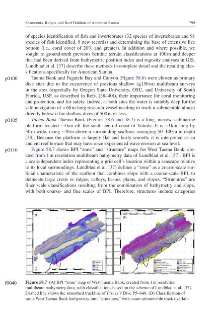
<strong>Seamounts</strong>, <strong>Ridges</strong>, <strong>and</strong> <strong>Reef</strong> <strong>Habitats</strong> <strong>of</strong> <strong>American</strong> <strong>Samoa</strong> 799p0100p0105p0110<strong>of</strong> species identification <strong>of</strong> fish <strong>and</strong> invertebrates (32 species <strong>of</strong> invertebrates <strong>and</strong> 91species <strong>of</strong> fish identified, 9 new records) <strong>and</strong> determining the base <strong>of</strong> extensive livebottom (i.e., coral cover <strong>of</strong> 20% <strong>and</strong> greater). In addition <strong>and</strong> where possible, wesought to ground-truth previous benthic terrain classifications at 100 m <strong>and</strong> deeperthat had been derived from bathymetric position index <strong>and</strong> rugosity analyses in GIS.Lundblad et al. [37] describe these methods in complete detail <strong>and</strong> the resulting classificationsspecifically for <strong>American</strong> <strong>Samoa</strong>.Taema Bank <strong>and</strong> Fagatele Bay <strong>and</strong> Canyon (Figure 58.6) were chosen as primarydive sites due to the occurrence <strong>of</strong> previous shallow (
800Seafloor Geomorphology as Benthic Habitatf0045Figure 58.8 (A) BPI “zone” map <strong>of</strong> FBNMS, created from 1 m resolution multibeambathymetry data, with classifications based on the scheme <strong>of</strong> Lundblad et al. [37]. Dashedline shows smoothed track <strong>of</strong> Pisces V Dive P5–649. (B) Classification <strong>of</strong> same FBNMSbathymetry into “structures,” with same submersible track overlain.p0115p0120p0125such as narrow depressions or grooves, narrows crests or ridges, local depressions/crests on plains, lateral mid-slope depressions or grooves, lateral mid-slope crests orridges, open slopes, shelves, <strong>and</strong> broad flats [37]. Zone <strong>and</strong> structure classifications<strong>of</strong> Taema Bank (Figure 58.7) are based on the scheme <strong>of</strong> Lundblad et al. [37] for<strong>American</strong> <strong>Samoa</strong>.Taema Bank is made up <strong>of</strong> mostly flats <strong>and</strong> slopes in terms <strong>of</strong> zones, but there arevery distinct crests <strong>and</strong> depressions throughout (Figure 58.7A). Open slopes surroundthe crests <strong>of</strong> the bank along with the broad flats. As the shelf reaches an escarpmentnear a series <strong>of</strong> broad flats, there is also a series <strong>of</strong> spurs <strong>and</strong> grooves. These pervasivefeatures are given structure classifications <strong>of</strong> narrow crests, lateral mid-slope depressions,<strong>and</strong> lateral mid-slope crests (Figure 58.7B). The open slopes lead down to broaddepressions with open bottoms on both sides <strong>of</strong> Taema Bank. Submersible observationson Dives P5–648 <strong>and</strong> P5–650 visually confirmed these classifications <strong>and</strong> noted thatthe shelf contains stretches <strong>of</strong> colonized pavement covered with a veneer <strong>of</strong> s<strong>and</strong> [41].Within the fringing lateral mid-slope depressions <strong>and</strong> crests on the open slopes are colonizedpavement <strong>and</strong> hummocky bottom with low relief <strong>and</strong> ~5% s<strong>and</strong> cover.Fagatele Bay <strong>and</strong> Canyon: Fagatele Bay (Figures 58.6 <strong>and</strong> 58.8), <strong>and</strong> its continuationdeeper <strong>of</strong>fshore as a canyon, is the result <strong>of</strong> an ancient caldera that collapsed<strong>and</strong> subsided, causing the seaward rim to be breached by the ocean <strong>and</strong> flooded [38].The fringing coral reef is indeed <strong>of</strong> continuing interest <strong>and</strong> concern in this US federalmarine sanctuary that has essentially recovered from a near-devastating infestation<strong>of</strong> crown-<strong>of</strong>-thorns starfish in the late 1970s [42]. The bay was also affected byhurricanes in 1990, 1991, 2004, <strong>and</strong> 2005; <strong>and</strong> a coral bleaching event occurred in1994, possibly due to high sea-surface temperatures from an El Niño [43]. The livecoral cover has recovered well from near-total destruction, <strong>and</strong> populations <strong>of</strong> smallbenthic fish still thrive, particularly surgeonfish, damselfish, <strong>and</strong> angelfish [44,45].The submerged caldera that is Fagatele Bay dramatically slopes downward intoa canyon (canyon has not yet been classified with regard to habitat). At around 20 m