Leafler Hiper SR English - Topcon Positioning
Leafler Hiper SR English - Topcon Positioning
Leafler Hiper SR English - Topcon Positioning

Create successful ePaper yourself
Turn your PDF publications into a flip-book with our unique Google optimized e-Paper software.
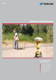
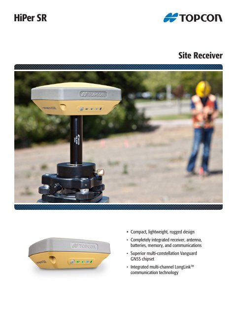
HiPer <strong>SR</strong>Site Receiver• Compact, lightweight, rugged design• Completely integrated receiver, antenna,batteries, memory, and communications• Superior multi-constellation VanguardGNSS chipset• Integrated multi-channel LongLink TMcommunication technology
HiPer <strong>SR</strong> Site ReceiverCompact. Rugged. Advanced. Affordable.Providing leading edge technology in a new smart, rugged design,the new HiPer <strong>SR</strong> provides superior performance at an affordable price.The compact, integrated receiver design includes the GNSS board,industry leading Fence Antenna TM , sealed long-life power supply, memorystorage and <strong>Topcon</strong>’s innovative LongLink TM communication technology.Rugged and LightweightThe HiPer <strong>SR</strong> is both lightweight and rugged.It is guaranteed to survive a 2m on the poledrop to concrete. The magnesium metalhousing is rugged and lightweight.With the HiPer <strong>SR</strong>, you don’t have to sacrifice durability and performanceto have a lightweight receiver. HiPer <strong>SR</strong> – a compact lightweight receiverthat is built to take the most intense environmental conditions and jobsite punishment.The design of the HiPer <strong>SR</strong> also provides a great deal of versatility,allowing the HiPer <strong>SR</strong> to be configured in a variety of ways depending onyour project requirements. Use a pair of HiPer <strong>SR</strong> receivers for a low-cost,completely cable free base and rover RTK system.Using <strong>Topcon</strong>’s LongLink TM RTK communication, HiPer <strong>SR</strong> makes the perfectaffordable, small job site system. HiPer <strong>SR</strong> also makes a great low-cost staticGNSS system that can be pre-programmed and operated in the field withjust one button. You can also utilize the HiPer <strong>SR</strong> as a network RTK rover byadding network functionality and a cellular enabled controller.Integrated DesignHiPer <strong>SR</strong> brings an innovative combination ofcompact, lightweight design with advancedtechnology and performance. The integrateddesign includes GNSS receiver, power supply,memory, and communications module – allin a rugged, environmentally sealed housing.Cable-Free DesignThis completely integrated receiver operatescable free in the field, with no antennas,battery doors, or connectors to worry about.The mini USB port is completely waterproof.Vanguard TechnologyThe latest <strong>Topcon</strong> GNSS chipset andfirmware provide Universal ChannelTracking. The receiver firmware canread existing satellite signals, and newsignals planned for the future.<strong>Topcon</strong>’s exclusive LongLink TM RTK technology provides the perfect shortrange RTK communication 1,000+ ft. (300+m) from the base station. Withthe HiPer <strong>SR</strong>, enjoy reliable, interference free RTK base-rover communicationthat doesn’t require an FCC license to operate. LongLink TM RTK technologyprovides superior performance in the toughest radio environments such asaround airports or city centers.
PRIMARY FEATURESVanguard GNSS ChipsetFence Antenna TM TechnologySquare “No Roll” DesignMINTER with super-bright LEDsIntegrated LongLink TM TechnologyMagnesium Alloy HousingWaterproof Comm. and Charging PortUSB Data PortFence Antenna TM TechnologyProvides superior satellite tracking indifficult conditions. The true separatorof precision GNSS systems is not howwell they can track in open areas, butin real-life situations with a variety ofobstructions. When compared to anyother RTK receiver available today, theHiPer <strong>SR</strong> with Fence Antenna TM Technologyprovides more robust, cleaner signaltracking which means unparalleled results.System Components• Main Unit• Battery Charger• Tribrach with adapter• 10cm pole adapter• Mini USB cable• Carrying CaseKIT COMPONENTS
HiPer <strong>SR</strong> Site ReceiverSPECIFICATIONSSOFTWARETrackingNumber of ChannelsSignals TrackedAntenna Type<strong>Positioning</strong> AccuracyRTK (L1+L2)Fast Static (L1)Fast Static (L1+L2)DGPS:SBAS:226 ChannelsGPS, GLONASS, SBAS, QZSS,Galileo, and COMPASS *Integrated Antenna withFence Antenna TM TechnologyH: 10 mm + 1.0 ppmV: 15 mm + 1.0 ppmH: 3 mm + 0.8 ppmV: 4 mm + 1.0 ppmH: 3 mm + 0.5 ppmV: 5 mm + 0.5 ppmH: .04 mV: .06 mH: 1.0 mV: 1.5 mA family of software solutions that streamlines the workflow for surveyors,contractors, engineers and mapping professionals.FieldModern User InterfaceMAGNET Field provides a bright, graphicaluser interface with large touch icons, andbright readable text. The screens not onlylook good, but provide fast workflows.CommunicationRTK BroadcastI/O CommunicationsLongLink TM 300m+ Range,Up to 3 simultaneous roversBluetooth ® , Serial, USBData and MemoryMemory4GB internal (Firmware limitof 2GB of static data)Real Time Data Output TPS, RTCM SC104 v 2.x, 3.x;CMR/CMR+ASCII Output NMEA 0183 version 2.x and 3.0PhysicalDimensions 6 x 6 x 1.5 in (w x d x h)150 x 150 x 64 mmWeight1.87lbs., 850gStatus Display / PanelExternal Power ConnectorOperation TimeEnvironmentalOperating temperatureStorage temperatureHumidityWater / DustproofMINTERYesUp to 20 hours-20ºC to +65ºCwith internal batteries-40ºC to +65ºCwith external power-40ºC to +70ºC100%, condensingIP67* Galileo and COMPASS support will be incorporated into HiPer <strong>SR</strong> whenthese constellations have matured and are ready for commercial use.For more specifications information:www.topcon-positioning.euEasy to UseThe icon and text field interface has beenoptimized to provide both text and imagesto indicate what data is needed on eachscreen. Shortcut buttons and fast accesstabs provide a very productive interface.Advanced CalculationsMAGNET Field not only controls the measurementsof the instrument but also provides many COGOand adjustment calculations.Office ToolsMAGNET Office ToolsDirectly integrates into Autodeskproducts utilizing their CADengine, or as a standaloneinstallation with <strong>Topcon</strong>’s OfficeSite and Office Topo. Either way,connect to MAGNET Enterprisedirectly from your CAD software.topcon.eu<strong>Topcon</strong> Europe <strong>Positioning</strong>, B.V • Essebaan 11• 2908 LJ - Capelle a/d IJssel • The Netherlands(+31) 10 4585077Specifications subject to change without notice. ©2012 <strong>Topcon</strong> CorporationAll rights reserved. P/N: 7010-2108 Rev. A Printed in U.S.A. 8/12The Bluetooth ® word mark and logos are registered trademarks owned byBluetooth SIG, Inc. and any use of such marks by <strong>Topcon</strong> is under license. Othertrademarks and trade names are those of their respective owners.Your local Authorized <strong>Topcon</strong> dealer is: