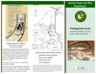
Angler Access RestrictionsIn addition to fishing area <strong>and</strong> season closures identified on pages 12-25, other fishing areas may be seasonally closeddue to bald eagle breeding areas <strong>and</strong>/or Wildlife Area restrictions.BALD EAGLE CLOSURESThe <strong>Arizona</strong> <strong>Game</strong> <strong>and</strong> <strong>Fish</strong> <strong>Department</strong>, in cooperation with the Southwestern Bald Eagle Management Committee <strong>and</strong> l<strong>and</strong> managementagencies, closes sensitive bald eagle breeding areas along <strong>Arizona</strong>’s rivers <strong>and</strong> lakes during five–eight months of the year. The closures preventpublic entry <strong>and</strong> deter human activity during critical times of the breeding cycle. you can identify the closure areas by looking for No Entrysigns on roads, trails <strong>and</strong> at boat ramps, <strong>and</strong> No Entry buoys on the water. For additional information on any closure, contact the <strong>Arizona</strong> <strong>Game</strong><strong>and</strong> <strong>Fish</strong> <strong>Department</strong>, Nongame Branch, (623) 236-7506.Lakes With Bald eagle BreedingClosure Areas• Crescent Lake – A portion of the dirt entranceroad to the west side may be restricted to a “nostopping zone” <strong>and</strong> a portion of l<strong>and</strong> near theparking area on the west side may be closed tofoot entry from April 1 through July 30. Contactthe Apache-Sitgreaves National Forest, SpringervilleRanger District, (928) 333-6200.• Greer Lakes (Tunnel <strong>and</strong> River) — Portions of thelakes may be closed to watercraft <strong>and</strong> a portionof the shoreline may be closed to foot entry fromMarch 1 through July 31. Contact the Apache-Sitgreaves National Forest, Springerville RangerDistrict, (928) 333-6200.• Lake pleasant – No vehicle, watercraft, or footentry is allowed into the Lower Agua Fria RiverArm from Dec. 15 to June 15. Contact MaricopaCounty Parks <strong>and</strong> Recreation, (928) 501-1710.• Lower Lake mary – There may be no vehicle orfoot traffic allowed on a portion of the north sideof the lake from Jan. 1 to Aug. 30. Contact theCoconino National Forest, Mormon Lake RangerDistrict, (928) 774-1147.• Luna Lake – There is no vehicle or foot trafficallowed on the north side from Jan. 1 to June 15.Contact Apache-Sitgreaves National Forest, AlpineRanger District, (928) 339-5000.• Lynx Lake – Portions of the lake’s east side maybe closed to vehicle or foot traffic <strong>and</strong> a portionof the shoreline may be closed to watercraft fromDec. 1 to June 30. Contact the Prescott NationalForest, Bradshaw Ranger District, (928) 443-8000.• show Low Lake – A portion of the lake may beclosed to watercraft <strong>and</strong> a portion of the shorelinemay be closed to foot entry from March 1 toAugust 31. Contact Apache-Sitgreaves NationalForest, Lakeside Ranger District, (928) 368-2100.• Whitehorse Lake — A portion of the shorelinemay be closed to foot entry from March 1 to August31. Contact Kaibab National Forest, WilliamsRanger District (928) 635-5600.• Woods Canyon Lake — A portion of the lakemay be closed to watercraft <strong>and</strong> a portion of theshoreline may be closed to foot entry from April 1through August 31. Contact the Apache-SitgreavesNational Forest, Black Mesa Ranger District, (928)535-7300.rivers/Creeks with Bald eagleBreeding Closure AreasVerde river• Verde River below Sycamore Canyon Wildernessis closed to foot <strong>and</strong> vehicle entry from Dec. 1to June 15. Floating through is allowed. ContactCoconino National Forest, Sedona Ranger District,(928) 282-4119.• Verde River near Chasm Creek is closed to foot<strong>and</strong> vehicle entry from Dec. 1 to June 15. Floatingthrough is allowed. Contact Prescott National Forest,Verde Ranger District, (928) 567-4121.• Verde River near Cold Water Creek, allows watercraftto float through but no stopping on the riveror l<strong>and</strong>ing is allowed Dec. 1 to June 30. ContactPrescott National Forest, Verde Ranger District,(928) 567-4121.• Verde River near East Verde River, allows watercraftto float through but no stopping on the riveror l<strong>and</strong>ing is allowed Dec. 1 to June 30. ContactTonto National Forest, Cave Creek Ranger District,(928) 595-3300.• Verde River near Mule Shoe Bend, allowswatercraft to float through but no stopping in theriver or l<strong>and</strong>ing is allowed from Dec. 1 to June 30.Contact Tonto National Forest, Cave Creek RangerDistrict, (480) 595-3300.• Verde River below Horseshoe Dam may be closedto vehicle or foot entry on the southwest side ofthe river from Dec. 1 to June 30. Floating throughis allowed, but no stopping in the river or l<strong>and</strong>ingon the southwest side of the river is allowed.Contact Tonto National Forest, Cave Creek RangerDistrict, (480) 595-3300.• Verde River below Bartlett Dam is closed to footor vehicle entry from Dec. 1 to June 30. Floatingthrough is allowed. Contact Tonto National Forest,Cave Creek Ranger District, (480)595-3300.• Verde River at the Needle Rock Recreation area isclosed to foot <strong>and</strong> vehicle entry on the east side ofthe river from Dec. 1 to June 30. Floating throughis allowed, but no stopping in the river or l<strong>and</strong>ingon east side of river is allowed. Contact TontoNational Forest, Cave Creek Ranger District, (480)595-3300.tonto Creek• Tonto Creek from Gisela to 76 Ranch is closed tovehicle, foot entry, <strong>and</strong> floating through from Dec.1 to June 30. Contact Tonto National Forest, TontoBasin Ranger District (928) 467-3200.• Tonto Creek inlet to Roosevelt Lake is closed tovehicle <strong>and</strong> foot entry within 1000 feet of the neston l<strong>and</strong>, <strong>and</strong> to watercraft within 300 feet on waterfrom Dec. 1 to June 30. Contact Tonto NationalForest, Tonto Basin Ranger District (928) 467-3200.salt river• Salt River from Horseshoe Bend to Redmond Flatallows watercraft to float through, but no stoppingin the river or l<strong>and</strong>ing is allowed from Dec. 1 toJune 30. Contact Tonto National Forest, GlobeRanger District, (928) 402-6200.• Salt River near Meddler Point is closed to vehicle<strong>and</strong> foot entry within 1000 feet of the nest on l<strong>and</strong>,<strong>and</strong> to watercraft within 300 feet on water fromDec. 1 to June 30. Contact Tonto National Forest,Tonto Basin Ranger District (928) 467-3200.• Salt River near Campaign Bay may be closed tovehicle <strong>and</strong> foot entry within 1000 feet of the neston l<strong>and</strong>, <strong>and</strong> to watercraft within 300 feet on waterfrom Dec. 1 to June 30. Contact Tonto NationalForest, Tonto Basin Ranger District (928) 467-3200.• Salt River below Stewart Mountain Dam, is closedto vehicle or foot entry on the south side of theriver from Dec. 1 to June 30. Floating through isallowed. Contact the Tonto National Forest, MesaRanger District, (480) 610-3300.• Salt River near Goldfield-Kerr Fire Station is closedto foot <strong>and</strong> vehicle entry on the north side of theriver from Dec. 1 to June 30. Floating throughis allowed. Contact Tonto National Forest, MesaRanger District, (480) 610-3300.ARIzONA GAME AND FISH DEPARTMENT WILDLIFE AREA RESTRICTIONS (R12-4-802)The following Wildlife Areas have seasonal closuresthat may affect fishing access to a portion of theselakes:• Luna Lake Wildlife Area: Posted portions closedto public entry from Feb. 15 through July 31 annually.• mittry Lake Wildlife Area: Posted portions closedto public entry from Nov 15 through Feb 15 annually.48 <strong>Arizona</strong> <strong>Game</strong> <strong>and</strong> <strong>Fish</strong> <strong>Department</strong> • www.azgfd.gov• roosevelt Lake Wildlife Area: Posted portionsclosed to public entry from Nov 15 through Feb 15annually.
Accessible <strong>Fish</strong>ing OpportunitiesBartlett Lake (21 miles east of Cave Creek)Rattlesnake Recreation Site• Parking, restrooms, fishing pierBecker Lake (2 miles west of Springerville)• Designated fishing pier, parkingBig Lake ( 25 miles south of Eagar)• Boat ramp <strong>and</strong> courtesy dock, parking,restroomsCanyon Lake (18 miles north of ApacheJunction)LaBarge Cove• Parking, fishing pier, restrooms, picnicfacilitiesPalo Verde Recreation Area• Boat ramp <strong>and</strong> courtesy dock, parking,restroomsCrescent Lake (22 miles south of Eagar)• Parking, restroomsFain Lake (City of Prescott Valley)• Restrooms, paved fishing accessFool hollow Lake (4 miles west of ShowLow)• Parking, restrooms, fishing docksKaibab Lake (2 miles north of Williams)• Designated fishing pierLake havasu (near Lake havasu City)Mesquite Cove• Parking, restrooms, fishing piersSite Six• Boat ramp <strong>and</strong> courtesy dock, parking,restrooms, fishing pierBill Williams Refuge Headquarters• Parking, restrooms, fishing dock, lightedpathwayTake-Off Point• Boat ramp <strong>and</strong> courtesy dock, parking,restroomsLake Havasu State Park• Boat ramp <strong>and</strong> courtesy dock, parking,restroomsLake mary, Upper (17 miles southeast ofFlagstaff)Day Use Site #2• Boat ramp <strong>and</strong> courtesy dock, parking,restroomsLake mohave (5 miles north of BullheadCity)Katherine L<strong>and</strong>ing,• Restrooms, fishing pierLake pleasant (15 miles north of Peoria)10 lane boat ramp• Boat ramp <strong>and</strong> courtesy dock, parking,restroomsLake powell (5 miles north of Page)Wahweep• Developed fishing pierLynx Lake (7 miles east of Prescott)• <strong>Fish</strong>ing pier, interpretive trail, parking,restroomsmittry Lake (14 miles north of yuma)• Parking, fishing jetty, asphalt trail, restrooms,boat docknelson reservoir (8 miles southwest ofSpringerville)• Parking, fishing ramadas, restroomsparker Canyon Lake (30 miles southwest ofSierra Vista)• Boat ramp <strong>and</strong> courtesy dock, parking,restrooms, fishing pierpatagonia Lake (10 miles northeast ofNogales)• Parking, restroomspena Blanca Lake (8 miles northwest ofNogales)• Boat ramp <strong>and</strong> courtesy dock, parking,restrooms, fishing pierredondo Lake• Parking, fishing pierriggs Flat Lake (15 miles southwest ofSafford)• Parking, trail access to shorelineroosevelt Lake (26 miles northwest ofGlobe)Cholla Recreation Area• Boat ramp <strong>and</strong> courtesy dock, passengerloading platform, parking, restroomsroper Lake (6 miles south of Safford)• Accessible dock, restrooms, parkingrose Canyon Lake (30 miles north ofTucson)• Parking, restrooms, shoreline accesssaguaro Lake (20 miles north of Mesa)Butcher Jones Cove• Parking, restroomsSaguaro del Norte• Boat ramp <strong>and</strong> courtesy dock, parking,restrooms, picnic facilities, fishing pierstopock marsh (4 miles north of GoldenShores)Catfish Paradise• RestroomsWillow springs Lake (17 miles west ofHeber)• Boat ramp <strong>and</strong> courtesy dock, parking,restroomsWoodl<strong>and</strong> Lake (Pinetop/Lakeside)• Parking, restrooms, fishing dockAll 36 designated Community<strong>Fish</strong>ing Lakes(Consult the 2014 Community <strong>Fish</strong>ing Programguidebook for locations in the Phoenix<strong>and</strong> Tucson areas, as well as Payson <strong>and</strong>yuma)• Parking, restrooms, shade, shoreline access,picnic facilities<strong>Fish</strong> identification,tips <strong>and</strong> resources2014 <strong>Arizona</strong> <strong>Fish</strong>ing Regulations 49