- Page 5 and 6: Executive SummaryMaintaining the ec
- Page 7 and 8: Map 1. The Hub Conservation Area ma
- Page 9 and 10: Map 3. Major elk linkages identifie
- Page 12 and 13: Map 6. Major mule deer linkages ide
- Page 14 and 15: Map 8. Major wolf linkages identifi
- Page 16 and 17: Map 10. Major grizzly bear linkages
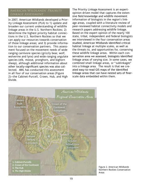
- Page 18 and 19: For information regarding contents
- Page 22 and 23: Georgetown Lake,photo by Grace Hamm
- Page 24 and 25: Beaverhead Mountains to the south,
- Page 26 and 27: with mountainous wet meadows and ri
- Page 28 and 29: irds). This step was repeated for c
- Page 30 and 31: Figure 4. Hierarchical breakdown of
- Page 32 and 33: sanitation and conflict issues betw
- Page 34 and 35: Literature ReviewThis review is mea
- Page 36 and 37: that this impediment is deleterious
- Page 38 and 39: may not provide functional connecti
- Page 40 and 41: available during dispersal, and new
- Page 43 and 44: and desert; this reflects overall a
- Page 45 and 46: Photo by Denver Bryanpopulations. L
- Page 47 and 48: Mountain goat (Oreamnos americanus)
- Page 49 and 50: GUIDE TO READINGPRIORITY LINKAGE AS
- Page 51 and 52: Absaroka to CraziesSpeciesGeographi
- Page 53 and 54: BangtailsSpeciesGeographic Boundary
- Page 55 and 56: Bear CreekSpeciesGeographic Boundar
- Page 58 and 59: Big BeltsSpeciesGeographic Boundary
- Page 60 and 61: to disease transmission between dom
- Page 62: sightings in the Birch Creek area.
- Page 65 and 66: Elk move within this linkage for wi
- Page 67: south of the linkage area.Wolverine
- Page 70 and 71:
ange for about 200 elk, and the Spr
- Page 72:
winter range is private land on the
- Page 75:
e using the Little Belt Mountains,
- Page 78 and 79:
Front south along the Continental D
- Page 80 and 81:
Clinton to DrummondSpeciesGeographi
- Page 82 and 83:
There has been a settlement with At
- Page 84 and 85:
Mountain Goats: The highest density
- Page 86 and 87:
suspected in very low levels, even
- Page 88:
dispersal corridor for all of these
- Page 91 and 92:
the area. Hunting access in general
- Page 93 and 94:
with the Elkhorns.Wolverines are kn
- Page 96 and 97:
FleecerSpeciesGeographic BoundaryFl
- Page 98 and 99:
negotiated grazing agreements on th
- Page 100 and 101:
traffic volumes are increasing sign
- Page 102 and 103:
pack in the linkage. The large size
- Page 104 and 105:
Garnets to BouldersSpeciesGeographi
- Page 106 and 107:
105
- Page 108 and 109:
persistent spring snow and may be k
- Page 110 and 111:
Garnets. The Clark Fork River Corri
- Page 112 and 113:
Horseshoe HillsSpeciesGeographic Bo
- Page 114 and 115:
Hound CreekSpeciesGeographic Bounda
- Page 116 and 117:
Jefferson SloughSpeciesGeographic B
- Page 118 and 119:
117
- Page 120 and 121:
Willow packs moved here from the po
- Page 122:
the high potential for conflict wit
- Page 125 and 126:
the Castle Mountains south of Whets
- Page 127 and 128:
Lolo to TurahSpeciesGeographic Boun
- Page 129 and 130:
path; this could further fragment w
- Page 131 and 132:
Lost TrailSpeciesGeographic Boundar
- Page 133 and 134:
MacDonald Pass toFleecer/Mt. Haggin
- Page 135 and 136:
claims within the area and 75 are b
- Page 137 and 138:
Conservation ThreatsDevelopment cou
- Page 139 and 140:
MaxvilleSpeciesGeographic BoundaryT
- Page 141 and 142:
Norris HillSpeciesGeographic Bounda
- Page 143 and 144:
PipestoneSpeciesGeographic Boundary
- Page 145 and 146:
144
- Page 147 and 148:
persistent snow pack.Lynx: Boles Cr
- Page 149 and 150:
Potter BasinSpeciesGeographic Bound
- Page 151 and 152:
150
- Page 153 and 154:
Mountain goats exist in small pocke
- Page 155 and 156:
Rocky Mountain Front to Big BeltMou
- Page 157 and 158:
Disease between bighorn sheep and d
- Page 159 and 160:
the linkage, grizzly bear forage in
- Page 161 and 162:
influencing how wildlife connectivi
- Page 163 and 164:
Several bighorn sheep herds form am
- Page 165 and 166:
Silver StarSpeciesGeographic Bounda
- Page 167 and 168:
166
- Page 169 and 170:
controlled. In recent years, approx
- Page 171 and 172:
esulting from livestock depredation
- Page 173 and 174:
StickneySpeciesGeographic BoundaryT
- Page 175 and 176:
SulaSpeciesGeographic BoundaryThe S
- Page 177 and 178:
Tom Miner to Mill CreekSpeciesGeogr
- Page 179 and 180:
178
- Page 181 and 182:
development. Subdivision, fencing a
- Page 183 and 184:
Townsend from 1000 to 300 animals.
- Page 185 and 186:
These appear to be important for gr
- Page 187 and 188:
186
- Page 189 and 190:
Other existing packs include the Wo
- Page 191 and 192:
Creek and the Boulder River south o
- Page 193 and 194:
192
- Page 195 and 196:
Harestad A.S., and F.L. Bunnell. 19
- Page 197 and 198:
Trakhtenbrot, A. R. Nathan, G. Perr
- Page 199 and 200:
Appendix 1 (cont.).Table 1Mammals o
- Page 201 and 202:
Appendix 2 (cont.).Table 2Home Rang
- Page 203 and 204:
Appendix 3 (cont.).Table 3Migration
- Page 205 and 206:
Appendix 4 (cont.).Table 4Dispersal
- Page 207 and 208:
Appendix 5 (cont.).Studies Demonstr
- Page 209:
American Wildlands ~ Winter 2008