

The Hub Conservation Area - Montanans 4 Safe Wildlife Passage
The Hub Conservation Area - Montanans 4 Safe Wildlife Passage
The Hub Conservation Area - Montanans 4 Safe Wildlife Passage

Create successful ePaper yourself
Turn your PDF publications into a flip-book with our unique Google optimized e-Paper software.
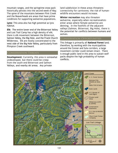
mountain ranges, and the springtime snow packhistorically persists into the second week of May.<strong>The</strong> spine of the mountains between Flint Creekand the Beaverheads are areas that have primeconditions for supporting wolverine populations.Lynx: This area also has high potential as lynxhabitat.Elk: <strong>The</strong> entire lower end of the Bitterroot Valleyand Lost Trail Camp has a high density of elk;there is elk movement between the Bitterroot,Salmon Valley, the Big Hole, and the Frank ChurchWilderness. Elk are mostly concentrated to thewest side of the Big Hole Valley, particularly fromPlimpton Creek southward.<strong>Conservation</strong> ThreatsDevelopment: Currently, this area is somewhatundeveloped, but there could be creepfrom the south end Bitterroot and SalmonValleys, and nearby ski areas. Any privateland subdivision in these areas threatensconnectivity for carnivores; the risk of humanwildlifeencounters would increase.Winter recreation may also threatenwolverine, especially when recreationalistsenter areas where female wolverine aredenning. In the foothills of the adjacentvalleys (Salmon, Bitterroot, Big Hole), there isthe potential for conflicts between humans andwolves.<strong>Conservation</strong> OpportunitiesThis linkage is primarily all National Forest land;therefore, by working with the municipalitiesaround the Conner and Sula corridors, a largemovement corridor could remain intact. <strong>The</strong>reis enough public land in this area to sustain wolfpacks despite the high probability of humanconflicts.Chaffin CreekCreekPiquettSpade CreekW Fork Bitterroot ROverwh ich CreekBlind DrawLaird CreekCreekWilesConnerSmoke CreekCreekHug hesBITTERROOTRANGECreekIndianRye C r eek£¤ 93 SulaMaynard CreekSula CreekCamp CreekCreekPraineHart CreekLost Trail CampHughes CreekHull CreekTwin CreekCreekCameronLost TrailPassCONTINENTAL DIVIDE£¤ 93TraiSAPPHIREMTNSRiverBitterroot East ForkTolan CreekMay CreekS heep CCreekMartinCreekMeadowl Cre ekCow CreekreekSwift Creek131CreekTieButler CreekSign CreekR uby C reekLick CreekAnaconda-PintlerWildernessHell Roaring CreekCreekBenderJohnson CreekCreekMoosePlimpton Creek¬« 43 BIG HOLEVALLEYRiverHole Big North ForkMifflin CreekBEAVERHEADMOUNTAINSRock CreekClam CreekBig CreekLakeVLand CoverLost Trail LinkageI DU. S. Forest ServiceMontana Fish,<strong>Wildlife</strong> & ParksorIdaho Fish & GameState LandsU.S. Bureau ofLand Mgmt.Private Land/OtherWilderness (USFS& USFWS)<strong>Conservation</strong>EasementsU.S. Fish & <strong>Wildlife</strong>ServicePlum Creek TimberCompany0 1.25 2.5 5MilesM T<strong>The</strong> <strong>Hub</strong>W Yµ

