- Page 1 and 2:
L 1 97768- 196 8. COUNTERS I D Muni
- Page 3 and 4:
97766--nwrmmm.xmm MINUTE BOOK No. 2
- Page 5 and 6:
97768—a.er.,cmgz MINUTE BOOK No.
- Page 7 and 8:
97768—wasm-arrace and MINUTE BOOK
- Page 9 and 10:
97768--mamos-main STATE OF MISSISSI
- Page 11 and 12:
97768— wcolole.-nmar: MINUTE BOOK
- Page 13 and 14:
97768— maens-xmasa MINUTE BOOK No
- Page 15 and 16:
97768—arcum-main MINUTE BOOK No.
- Page 17 and 18:
s. 97768--Kupwwmos MINUTE BOOK No.
- Page 19 and 20:
97768-- wwwwilmon MINUTE BOOK No. 2
- Page 21 and 22:
MINUTE BOOK NO. 24, CITY OF OXFORD
- Page 23 and 24:
MINUTE BOOK NO. 2 4, CITY OF OXFORD
- Page 25 and 26:
it 97768- MINUTE BOOK No. 24, CITY
- Page 27 and 28:
97768— Kraosallumax .. MINUTE BOO
- Page 29 and 30:
97768— analm-wwea CITY LERK MINUT
- Page 31 and 32:
97768 arrnerFINTME: MINUTE BOOK No.
- Page 33 and 34:
97768— worm-maw MINUTE BOOK No. 2
- Page 35 and 36:
97768— rain MINUTE BOOK No. 24, C
- Page 37 and 38:
97768— Nerasm-anex MINUTE BOOK No
- Page 39 and 40:
97768— xnemn-oarwez MINUTE BOOK N
- Page 41 and 42:
97768- TPLI MINUTE BOOK No. 24, CIT
- Page 43 and 44:
977613— Kumoss-mnan MINUTE BOOK N
- Page 45 and 46:
97768— Ertarnmurtact MINUTE BOOK
- Page 47 and 48:
97768- 1.1C1•1211-ROCM MINUTE BOO
- Page 49 and 50:
97768— ral a os- waasz MINUTE BOO
- Page 51 and 52:
fi 97768— arcason-sorm MINUTE BOO
- Page 53 and 54:
97768- NITCMONSMATCIIIS MINUTE BOOK
- Page 55 and 56:
97768— Tun MINUTE BOOK No. 24, CI
- Page 57 and 58:
97768--mumermun MINUTE BOOK No. 24,
- Page 59 and 60:
11 97768-- wrommmwom MINUTE BOOK No
- Page 61 and 62:
97768—mamowsmom MINUTE BOOK No. 2
- Page 63 and 64:
97768 memee-stran MINUTE BOOK No. 2
- Page 65 and 66:
97768— magol-gamax MINUTE BOOK No
- Page 67 and 68:
97768— artswes-nmem MINUTE BOOK N
- Page 69 and 70:
97788— mares.rtacx MINUTE BOOK No
- Page 71 and 72:
97769— aroma-wpm • MINUTE BOOK
- Page 73 and 74:
97768— artmet-attez MINUTE BOOK N
- Page 75 and 76:
97768— arcem-maaa MINUTE BOOK No.
- Page 77 and 78:
97768- RIPIONN-IMITINS MINUTE BOOK
- Page 79 and 80:
97768- 1101.161AWCIZ MINUTE BOOK No
- Page 81 and 82:
97768 — xeramon-arar: ORIGINAL CO
- Page 83 and 84:
97768- lattliMB-114TPILI MINUTE BOO
- Page 85 and 86:
97768—i.rouwy.mc MINUTE BOOK No.
- Page 87 and 88:
If I t 97768— rnowes-katase MINUT
- Page 89 and 90:
9.7768- 117116101.M112 MINUTE BOOK
- Page 91 and 92:
97768— aramps-ww. MINUTE BOOK No.
- Page 93 and 94:
97 7 6 8— nruor-raace MINUTE BOOK
- Page 95 and 96:
97768--mamoraram MINUTE BOOK No. 24
- Page 97 and 98:
97768—nuarms-ommin REGULAR MEETIN
- Page 99 and 100:
97768- MINUTE BOOK No. 24, CITY OF
- Page 101 and 102:
97768- MINUTE BOOK No. 24, CITY OF
- Page 103 and 104:
97768— arclion-attoct MINUTE BOOK
- Page 105 and 106:
MINUTE BOOK No. 24, CITY OF OXFORD
- Page 107 and 108:
9776E1= maim-mew ATTEST: -s-A7 MINU
- Page 109 and 110:
97768— min MINUTE BOOK No. 24, CI
- Page 111 and 112:
97768— navasms-amaz MINUTE BOOK N
- Page 113 and 114:
97768- MINUTE BOOK No. 24, CITY OF
- Page 115 and 116:
97768— roma MINUTE BOOK No. 24, C
- Page 117 and 118:
11 97768.— www-wrom MINUTE BOOK N
- Page 119 and 120:
i i Ij 97768— Ton MINUTE BOOK No.
- Page 121 and 122:
97768 1,27001N-IMP*2 MINUTE BOOK No
- Page 123 and 124:
RECESS, RECESS, RECESS REGULAR MEET
- Page 125 and 126:
97768--momm-mailm MINUTE BOOK No. 2
- Page 127 and 128:
' ' 97768— mmonArmet OPERATING RE
- Page 129 and 130:
977613—momme-mmem REGULAR MEETING
- Page 131 and 132:
97768— ma mo-att o MINUTE BOOK No
- Page 133 and 134:
97768-- Remma-momm MINUTE BOOK No.
- Page 135 and 136:
97768— MINUTE BOOK No. 24, CITY O
- Page 137 and 138:
97768— arruate-macmz MINUTE BOOK
- Page 139 and 140:
97768— geramwmawsz MINUTE BOOK No
- Page 141 and 142:
97768— uroom-ourtacc MINUTE BOOK
- Page 143 and 144:
97768— arramss-sacars MINUTE BOOK
- Page 145 and 146:
977613— tinamm-wava MINUTE BOOK N
- Page 147 and 148:
97768—mammi-mou REGULAR MEETING M
- Page 149 and 150:
97768— Tom MINUTE BOOK No. 24, CI
- Page 151 and 152:
97768- UMMIM-MICIILI MINUTE BOOK No
- Page 153 and 154:
97768— Nerawa.-tuame. MINUTE BOOK
- Page 155 and 156:
97768- T.12 MINUTE BOOK No. 24, CIT
- Page 157 and 158:
97768— wawa-wan MINUTE BOOK No. 2
- Page 159 and 160:
97768- TOR TO: A. B. CULLEN & SON P
- Page 161 and 162:
977613- wasmAimuts MINUTE BOOK No.
- Page 163 and 164:
97768 wrowirs-urace MINUTE BOOK No.
- Page 165 and 166:
97768 mummewumel TY C ERK MINUTE BO
- Page 167 and 168:
97768— nownarourteart MINUTE BOOK
- Page 169 and 170:
97768.— wrommmoin MINUTE BOOK No.
- Page 171 and 172:
97768- MINUTE BOOK No. 24, CITY OF
- Page 173 and 174:
97768— mrrama-ruaacx MINUTE BOOK
- Page 175 and 176:
97768- MISIIINHINIMIS MINUTE BOOK N
- Page 177 and 178:
97768--moommalum REGULAR MEETING MI
- Page 179 and 180:
97768— xmaies..m.E1 P. BE IT RESO
- Page 181 and 182:
97768.--mum.immova MINUTE BOOK No.
- Page 183 and 184:
97768 rxrum.sucara MINUTE BOOK No.
- Page 185 and 186:
■ MINUTE BOOK No. 24, CITY OF OXF
- Page 187 and 188:
7768-- mumml-mmum, MINUTE BOOK No.
- Page 189 and 190:
97768 —mmoo-imuct MINUTE BOOK No.
- Page 191 and 192:
97768- WICISMIHICCULI MINUTE BOOK N
- Page 193 and 194:
MINUTE BOOK NO. 24, CITY OF OXFORD
- Page 195 and 196:
Ii 9776.8— TtleZ STATE OF MISSISS
- Page 197 and 198:
97768- TOM MINUTE BOOK No. 24, CITY
- Page 199 and 200:
97768- WINIIINHIATME REGULAR MEETTN
- Page 201 and 202:
MINUTE BOOK NO. 24, CTTY OF OXFORD
- Page 203 and 204:
97768- 111=1.111.11ATCWS MINUTE BOO
- Page 205 and 206:
1 97768- RT21111N-NiTOXIS MINUTE BO
- Page 207 and 208:
97768--momm-laron MINUTE BOOK No. 2
- Page 209 and 210:
97768— xrmans-eurclin MINUTE BOOK
- Page 211 and 212:
97768— urconw-attasz MINUTE BOOK
- Page 213 and 214:
97768— gamma-mama MINUTE BOOK No.
- Page 215 and 216:
97768— gemos-geort MAYOR MINUTE B
- Page 217 and 218: fj 97768 — aroma-Km= MINUTE BOOK
- Page 219 and 220: 97768- WICIIIIIM-11..42 MINUTE BOOK
- Page 221 and 222: 97768- 11FRUM-INTMEZ MINUTE BOOK No
- Page 223 and 224: ii H 97768 Keroom-rwacx MINUTE BOOK
- Page 225 and 226: 97768— wrames-maraot MINUTE BOOK
- Page 227 and 228: 1 11 97768— xrrawes-avace MINUTE
- Page 229 and 230: 97768- 1.11114101-11MEI MINUTE BOOK
- Page 231 and 232: 97768— maim-maw= MINUTE BOOK No.
- Page 233 and 234: 97768- TIM MINUTE BOOK No. 24, CITY
- Page 235 and 236: 97768— maz * * * acne on for c
- Page 237 and 238: 1 97768- MINUTE BOOK No. 24, CITY O
- Page 239 and 240: 977613— nerameratteasz MINUTE BOO
- Page 241 and 242: ij 97768— wromm-luapea MINUTE BOO
- Page 243 and 244: 97768- IMISIMN-11.4112 MINUTE BOOK
- Page 245 and 246: 9776E1- CROMM-IMIOS2 MINUTE BOOK No
- Page 247 and 248: 97768 lernotwattelez MINUTE BOOK No
- Page 249 and 250: 97768— Knomsa-Rama MINUTE BOOK No
- Page 251 and 252: 97768 Krrowee-nama MINUTE BOOK No.
- Page 253 and 254: • 97768— avama-main MINUTE BOOK
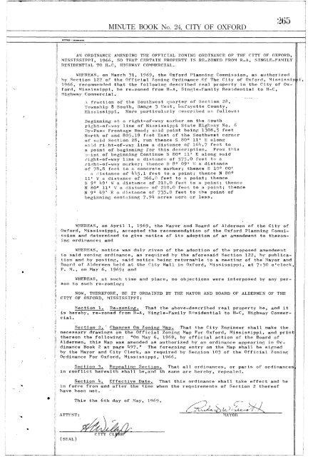
- Page 255 and 256: 97768- MINUTE BOOK No. 24, CITY OF
- Page 257 and 258: 97768— orrown-wmat MINUTE BOOK No
- Page 259 and 260: 97768— urames-amer, MINUTE BOOK N
- Page 261 and 262: 97768— suclows-xmoce MINUTE BOOK
- Page 263 and 264: 1 97768— arm.“-wain REGULAR MEE
- Page 265 and 266: 97768—wommi-larau MINUTE BOOK No.
- Page 267: 97768 RZIOIN-IMTEXIS MINUTE BOOK No
- Page 271 and 272: 97768— xenuomerkamaz MINUTE BOOK
- Page 273 and 274: 977613—armorol-mos. REGULAR MEETI
- Page 275 and 276: 97768— Ton MINUTE BOOK No. 24, CI
- Page 277 and 278: 1 97768— max MINUTE BOOK No. 24,
- Page 279 and 280: 97768— mumem-Koolez MINUTE BOOK N
- Page 281 and 282: 1 97768— aromm-aupors MINUTE BOOK
- Page 283 and 284: 97768--maimilquacion MINUTE BOOK No
- Page 285 and 286: 97768.—mme.motur MINUTE BOOK No.
- Page 287 and 288: 97768- MINUTE BOOK No. 24, CITY OF
- Page 289 and 290: 97768--mmommumma MINUTE BOOK No. 24
- Page 291 and 292: 97768—lanimr-mum MINUTE BOOK No.
- Page 293 and 294: 97768- ItEMOIN-IIMALS MINUTE BOOK N
- Page 295 and 296: 97768— arems-attnex MINUTE BOOK N
- Page 297 and 298: 97768— mcwass-auract MINUTE BOOK
- Page 299 and 300: 97768--lommewirou MINUTE BOOK No. 2
- Page 301 and 302: 97768 imummil-mmire MINUTE BOOK No.
- Page 303 and 304: 977138— mamas-m.0= MINUTE BOOK No
- Page 305 and 306: 97768 1.70111WICC1112 MINUTE BOOK N
- Page 307 and 308: 97768- MUMIIHICOME MINUTE BOOK No.
- Page 309 and 310: 97768— memos-turacx MINUTE BOOK N
- Page 311 and 312: 97768— onnwor-samet MINUTE BOOK N
- Page 313 and 314: 97768- Kr* MINUTE BOOK No. 24, CITY
- Page 315 and 316: 97768- MINUTE BOOK No. 24, CITY OF
- Page 317 and 318: 97768--merame-mma MINUTE BOOK No. 2
- Page 319 and 320:
97768—ismommuarim MINUTE BOOK No.
- Page 321 and 322:
97768— larrawas-Rwrom MINUTE BOOK
- Page 323 and 324:
97768— mumews-ama. MINUTE BOOK No
- Page 325 and 326:
97768-- mommalsa DISBURSEMENTS: Sal
- Page 327 and 328:
97768- NEIMM-IlatNet MINUTE BOOK No
- Page 329 and 330:
97768--mommi-omm MINUTE BOOK No. 24
- Page 331 and 332:
97768— argeols-mmax MINUTE BOOK N
- Page 333 and 334:
the amount of Five Thousand Dollars
- Page 335 and 336:
0471A 004- 97768— mume-wmaz MINUT
- Page 337 and 338:
PJe 9776 13.--wrommumm MINUTE BOOK
- Page 339 and 340:
97768- RIVIIWMATCM2 MINUTE BOOK No.
- Page 341 and 342:
340 977613— meroons-itema MINUTE
- Page 343 and 344:
97768- IMOOMMI.M04 MINUTE BOOK No.
- Page 345 and 346:
3 44 97768 IMINNNWCIZI MINUTE BOOK
- Page 347 and 348:
346 97768- NUCIMI-PAISIII2 Expendit
- Page 349 and 350:
97768— aroma-sena MINUTE BOOK No.
- Page 351 and 352:
97768— araros-tarma MINUTE BOOK N
- Page 353 and 354:
."; 0 11 CY 4.4 97768 IMICIONII-MAT
- Page 355 and 356:
97768 MLICIINWINTM MINUTE BOOK No.
- Page 357 and 358:
97768— Nners-Isacm DISBURSEMENTS:
- Page 359 and 360:
97768- NUCIMOB-11ATM MINUTE BOOK No
- Page 361 and 362:
311 97768 —mmes-wromt MINUTE BOOK
- Page 363 and 364:
'64 97768— =maw= MINUTE BOOK No.
- Page 365 and 366:
97768--mumwmoun MINUTE BOOK No. 24
- Page 367 and 368:
97768 mommeluma MINUTE BOOK No. 24,
- Page 369 and 370:
97768— Immon-onaele MINUTE BOOK N
- Page 371 and 372:
0 7 97768- 137tMleMINCINZ MINUTE BO
- Page 373 and 374:
37 9,788- ...,12112 MINUTE BOOK No.
- Page 375 and 376:
!I 97768—mummiqmom ATTEST: MINUTE
- Page 377 and 378:
97768— ornams.cact MINUTE BOOK No
- Page 379 and 380:
9776E1 ooneas.ana MINUTE BOOK No. 2
- Page 381 and 382:
97768-- mammi-mum STATE OF ARKANSAS
- Page 383 and 384:
8 8 97768--mmwomet MINUTE BOOK No.
- Page 385 and 386:
- 4 p 977673— onlOPM-luttm KNOW A
- Page 387 and 388:
97768— aroma-won MINUTE BOOK No.
- Page 389 and 390:
97768 — wore•-wata MINUTE BOOK
- Page 391 and 392:
977613— mums...Taw MINUTE BOOK No
- Page 393 and 394:
318 97768- IIRMIN-11ffelln MINUTE B
- Page 395 and 396:
MINUTE BOOK No. 24, CITY OF OXFORD
- Page 397 and 398:
' '2 9776E1— urnem-xamax MINUTE B
- Page 399 and 400:
97768 — tarams-Rom MINUTE BOOK No
- Page 401 and 402:
97768— arames-konce REGULAR MEETI
- Page 403 and 404:
4 j' 97768 IMIEM1114147C116 MINUTE
- Page 405 and 406:
41 97768 —ammos-urom MINUTE BOOK
- Page 407 and 408:
97768--mommHomm MINUTE BOOK No. 4,
- Page 409 and 410:
414 977613--mmormon MINUTE BOOK No.
- Page 411 and 412:
97768- IMO010-114TOZE MINUTE BOOK N
- Page 413 and 414:
4 97768— menow-goact MINUTE BOOK
- Page 415 and 416:
1 4 ti 97768 ummi► amm MINUTE BOO
- Page 417 and 418:
et 97768— “srame-larace MINUTE
- Page 419 and 420:
41 (1 97768—mmos-warom MINUTE BOO
- Page 421 and 422:
97768--mmwousom MINUTE BOOK No. 24.
- Page 423 and 424:
414 97768— werrowouarz MINUTE BOO
- Page 425 and 426:
4" 97768— larrom.srea MINUTE BOOK
- Page 427 and 428:
97768- WICIINIFILUCINZ CITY CLE MIN
- Page 429 and 430:
97768 aramwmama MINUTE BOOK No. 24,
- Page 431 and 432:
97768— wawa-Ream MINUTE BOOK No.
- Page 433 and 434:
97768— lerrame-ounta MINUTE BOOK
- Page 435 and 436:
97768— marwouract MINUTE BOOK No.
- Page 437 and 438:
434 977613— arcions-rwroct MINUTE
- Page 439 and 440:
♦4 (is e)0 97768--mmowlimam MINUT
- Page 441 and 442:
400 977613.— mms.ama MINUTE BOOK
- Page 443 and 444:
440 97768 arelINWIIRCNIS MINUTE BOO
- Page 445 and 446:
4/11 97768-- mmuHumes MINUTE BOOK N
- Page 447 and 448:
446 97768.—mmeHuma MINUTE BOOK No
- Page 449 and 450:
448 97768- IMIMIN-IIMPIH MINUTE BOO
- Page 451 and 452:
4h0 97768 MINUTE BOOK No. 24, CITY
- Page 453 and 454:
4o2 97768--mmwomum Attest: MINUTE B
- Page 455 and 456:
454 97768— arempos-attact MINUTE
- Page 457 and 458:
4U 9776B—mmn-rama MINUTE BOOK No.
- Page 459 and 460:
458 977613 NUCIM*1-11=111Z MINUTE B
- Page 461 and 462:
46 (1 97768 wrawas-Kama MINUTE BOOK
- Page 463 and 464:
97768 umme.wrnc MINUTE BOOK No. 24,
- Page 465 and 466:
97768--mmwmon MINUTE BOOK No. 24, C
- Page 467 and 468:
6 ii 97768 MCNIIIMATOM MINUTE BOOK
- Page 469 and 470:
97768—mmumm-mon MINUTE BOOK No. 2
- Page 471 and 472:
97768--mumwomme MINUTE BOOK No. 24,
- Page 473 and 474:
A 4 97768--mlem.ma MINUTE BOOK No.
- Page 475 and 476:
97768 IMENIONMATCM MINUTE BOOK No.
- Page 477 and 478:
47S 97768 nverree-macmg MINUTE BOOK
- Page 479 and 480:
97768-- immi-mone MINUTE BOOK No. 2
- Page 481 and 482:
4,t)2 97768— anives-urow MINUTE B
- Page 483 and 484:
4S4 97768—mmwmarim MINUTE BOOK No
- Page 485 and 486:
97768 — artales-earou MINUTE BOOK
- Page 487 and 488:
97768--mgrams.wom REGULAR MEETING M
- Page 489 and 490:
49( 97768—mmo ►wrom MINUTE BOOK
- Page 491 and 492:
402 97768—wrommwommu MINUTE BOOK
- Page 493 and 494:
4(J4 97768- IMILIM14.01112 MINUTE B
- Page 495:
97768- IMICIMINUTOISZ MINUTE BOOK N