

Vision 2020 Map - Arlington, MA
Vision 2020 Map - Arlington, MA
Vision 2020 Map - Arlington, MA

You also want an ePaper? Increase the reach of your titles
YUMPU automatically turns print PDFs into web optimized ePapers that Google loves.
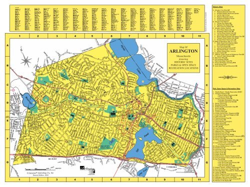
Historic SitesAB1 2 3 4 5 6 7 8 9 10 1145<strong>Map</strong> OfARLINGTONMassachusettsfeaturingHISTORIC SITESPARKS & OPEN SPACERECREATION LOCATIONSPRINTED BY ARLINGTON LITHOGRAPHABA <strong>Arlington</strong> Civic Block E7Robbins Memorial Town HallWinfield Robbins Memorial GardenCentral High SchoolRobbins Memorial LibraryWhittemore-Robbins House• Old Burying GroundB <strong>Arlington</strong> Fire Stations• Central Fire Station E8• Highland Fire Station E5• Park Circle Fire Station F4C <strong>Arlington</strong> Historic Districts• Avon Place Historic Dist. E8Broadway Historic Dist. E8Central Street Historic Dist. D7Jason/Gray Historic Dist. E-F7Mount Gilboa/Crescent Hill Historic Dist. D2Pleasant Street Historic Dist. E-G7• Russell Street Historic Dist. D7D Battle of Menotomy, April 19, 1775• Battle Road Event Markers D3-8(along Massachusetts Ave.)• Foot of the Rocks D3• Jason Russell Farmhouse E7Paul Revere Ride = •••••• William Dawes Ride = x x x xE Cooke’s Hollow D7F Jefferson Cutter House at Whittemore Park E8• Cyrus E. Dallin Museum E8G Main Post Office E7H Old Schwamb Mill D3J Park Circle Water Tower F4K Prince Hall Mystic Cemetery E10L Smith Museum E7M Uncle Sam Park and Monument E8403337426CCDEFG151732219C251312Second Edition, 20022031DHB3828J73 18113456BA PROUD PASTA FOCUSED FUTURE431 2 3 4 5 6 7 8 9 10 112342LDC8C30G44CCAD22M9EF D36DD BC36C293514163927102139K411DEFGPark, Open Space & Recreation Sites1. Alewife Brook / Alewife Reservation D-G112. <strong>Arlington</strong> Reservoir D2• Mount Gilboa Playground D2• Reservoir Beach D23. <strong>Arlington</strong> Sports Center D4• <strong>Arlington</strong> Recreation Office D4• Veterans’ Memorial Rink D44. Bishop School C75. Brackett School F46. Brattle Street Conservation Area D57. Buck Field D48. Buzzell Field D79. Cooke’s Hollow D710. Crosby School Park / Playground E1011. Cutter Park / Reinhart Playground E412. Dallin School F213. Florence Avenue Park F214. Gibbs School E915. Great Meadow (Lexington)16. Hardy School F917. Hibbert Street Park F118. Hill’s Hill D419. Hurd Field E220. Locke School Playground E321. Magnolia Park / Playground G1022. Meadowbrook Park C723. Menotomy Rocks Park F5-G624. Minuteman Bikeway (Donald R. Marquis)25. Mount Gilboa D226. Mystic Lakes A6-C8 / Mystic River C8-D10• Mystic River Reservation C8-D1027. North Union Park / Lussiano E10• Thompson School E1028. Ottoson Middle School / Crusher Lot E429. Parallel Park C830. Parmenter School Playground E731. Peirce School C332. Poets Corner G233. Reed’s Brook C234. Robbins Farm / Skyline Playground F435. Scannell-Santini Field (Linwood Street) F836. Spy Pond E-G8Conservation Lot G8Spy Pond Field (Hornblower) E8Spy Pond Park E-F8• Spy Pond Playground E837. Stratton School / Greeley Playground C538. Summer Street Field / Playground D439. Thorndike Field / Thorndike St. Wetlands G1040. Turkey Hill B3-C441. Waldo Playground (Teel Street) F1142. Warren A. Peirce Field / <strong>Arlington</strong> H.S. D643. Wellington Park (Grove Street) D544. Whittemore-Robbins House Grounds E745. Window on the Mystic A6
Historic SitesMenotomy, Settled 1635West Cambridge, Incorporated 1807<strong>Arlington</strong>, Renamed 1867A. <strong>Arlington</strong> Civic BlockThe area known as Menotomy was settledby English Puritans around 1635. Within a fewyears, many of the major roads were laid out-Massachusetts Avenue (1636), Pleasant Street(1638), and Mystic Street (1643).At the junction of Massachusetts Avenueand Pleasant Street, a new meeting house wasbuilt in 1734, the Second Parish of Cambridge.On the same corner today, you can see themodern First Parish Unitarian UniversalistChurch, built after the fourth parish buildingburned in 1975. Next to the church is the OldBurying Ground, which received its firstburial about 1735. A small section of the early(1762-1783) stone wall that surrounded thegrounds still stands behind the church. BothMinutemen and British soldiers, who died onApril 19, 1776, are buried here. An old graniteobelisk marks the common grave of 12Minutemen from Menotomy and otherMiddlesex towns.Always the most prestigious address onthe avenue, the Whittemore-Robbins Houseis a Federal-style mansion built about 1800, theearliest building remaining on the Civic Block.William Whittemore, first resident of thehouse, owned a factory on this site. With hisbrother Amos, he manufactured the cards usedto straighten cotton and wool fibers before theyare spun into yarn. The invention of themachine to make cards ensured the prosperityof both the Whittemores and West Cambridge.In 1847, Nathan Robbins, then thewealthiest citizen of <strong>Arlington</strong>, bought thehouse. Nathan, a widower, was joined by thefour children of his late son Orrin: Ida, Olney,Eliza, and Caira. Their family, especially theRobbins sisters, contributed much to <strong>Arlington</strong>.In 1931, Ida and Caira gave their house to theTown. Now restored, the house is used as afunction facility and for Town offices,including the Department of Human Servicesand the <strong>Arlington</strong> Historical Commission,curators for the Whittemore-Robbins House.In 1890, the Whittemore-Robbins Housewas rotated 90° and moved back to its presentlocation to make room for the RobbinsMemorial Library. This impressive buildingincludes the highly ornamented ReadingRoom. Additions were built in 1930 and 1994.In 1894, a new high school was built atthe corner of Academy and <strong>Map</strong>le Streets.Designed by the firm of Hartwell andRichardson, the red brick towers and turretsreflect the Romanesque style popular at thetime. Today the building holds a Senior Centerand offices.The Robbins Memorial Town Hall andWinfield Robbins Memorial Garden werealso donated to the Town by the Robbinsfamily. The Town Hall was dedicated in thesummer of 1913 with a large ceremony andpageant. The Robbins sisters asked the notedarchitect R. Clipston Sturgis to design thebuilding and to lay out the grounds as an“ornamental park.” Menotomy Indian Hunterby Cyrus Dallin is the central feature of thegarden. Dallin, who lived and worked in<strong>Arlington</strong>, is known for his sculpture, Appealto the Great Spirit, in front of the Museum ofFine Arts in Boston. The present gardendesign was completed by the Olmsted firm in1939. The garden and Town Hall are on theNational Register of Historic Places.B. <strong>Arlington</strong> Fire StationsThere are three fire stations in <strong>Arlington</strong>,all designed by George Ernest Robinson, aBelmont architect. The Central Fire Station(1926) was the first octagonal fire station inthe United States, allowing fire trucks toemerge simultaneously in six directions. Thetall tower was built to dry fire hoses easily.Built a few years later, the Highland FireStation is on Massachusetts Avenue nearBrattle Square. The Park Circle Fire Station,serving <strong>Arlington</strong> Heights, is near the ParkCircle Water Tower.C. <strong>Arlington</strong> Historic Districts<strong>Arlington</strong> is fortunate to have sevenhistoric districts located throughout the town.Most recently, in 2002, the Pleasant StreetHistoric District was expanded to includePelham Terrace. Other districts are Jason-Gray,Avon Place, Mt. Gilboa, Broadway, RussellStreet, and Central Street. The “historicdistrict” designation documents and protectsthe architectural character and significance ofearly neighborhoods. Each district isadministered by a volunteer neighborhoodcommission under Town By-laws andCommonwealth statutes.D. Battle of Menotomy, April 19, 1775Some of the first encounters betweenBritish regulars and Minutemen occurred inwhat is now <strong>Arlington</strong>. Markers alongMassachusetts Avenue indicate significant sitesand events of the historic day, April 19, 1775.Erected in 1878 for the centennial celebrationof the American Revolution, granite markerstell the stories of Menotomy citizens and placeswhich include the Black Horse Tavern wherethe Committee of Safety met on the nightbefore the battle. Sites of several skirmishesare also marked.Foot of the Rocks is located at thejunction of Lowell Street and MassachusettsAvenue. Here Minutemen from 30 townsgathered to ambush the British on their retreatfrom Lexington and Concord. The rockywooded hillside offered protection to theMinutemen who fired on the British. LordPercy turned his cannon around on the patriotsand that afternoon, as Percy retreated, moremen died in the Battle of Menotomy than inany other location on April 19, 1775.The Jason Russell Farmhouse (ca. 1740)is the site of <strong>Arlington</strong>’s annual reenactment ofthe battle. After a failed ambush on the Britishsoldiers, Jason Russell and eleven others werepursued inside the house and slain there. Thekitchen is said to have been ankle deep in theblood of the patriots, and to this day severalbullet holes can be seen in the house. Todaythe house is the headquarters of the <strong>Arlington</strong>Historical Society and is open to the public.In the early hours of the morning of April19th, both Paul Revere and William Dawesrode through the town warning of the approachof the British. Every year on Patriots’ Day, theirrides are repeated through the town.The marker to the heroics of SamuelWhittemore, now in Whittemore Park onMassachusetts Avenue in <strong>Arlington</strong> Center,reads “Near this spot, Samuel Whittemore,then 80 years old, killed three British soldiersApril 19, 1775. He was shot, bayoneted,beaten and left for dead, but recovered, andlived to be 98 years of age.” SamuelWhittemore’s grave is in the Old BuryingGround.E. Cooke’s HollowThe small park at Cooke’s Hollow is builtwhere Mill Brook emerges and flows ontoward the Mystic Lakes. Here you can see adrop in elevation, indicating the location of adam that created a large mill pond above it.There were mills on this site until the early1900’s. The last mill buildings burned in 1928.The park is named for Captain GeorgeCooke, recipient of the original grant of a millprivilege on Mill Brook. His grist mill, builtabout 1637 near this site, was the first tosupply the area with ground corn. Cookeserved in many public posts, including Speakerof the Massachusetts House of Representatives.F. Jefferson Cutter HouseBuilt about 1819, this house with itsornate entry originally stood farther west onMassachusetts Avenue near the corner ofQuinn Road. Now restored, the house standsin Whittemore Park in <strong>Arlington</strong> Center. Itholds the <strong>Arlington</strong> Chamber of CommerceVisitor’s Center and features the Cyrus E.Dallin Museum.The Cutters are one of the oldest familiesin <strong>Arlington</strong>. As early as 1637, William Cutterfarmed in the area, and by the time of the battleat the Foot of the Rocks, the Cutter familyowned the rights to operate three mills,including a grist mill where the Old SchwambMill stands today, and a sawmill near Mill St.off Massachusetts Ave.G. Main Post OfficeThe Main Post Office, built in 1936, ison Court Street in <strong>Arlington</strong> Center. Inside is alarge mural, painted by William C. Palmer in1938, under the WPA Federal Art Project.Purchase and Use of the Soil has three sectionsdepicting the history of <strong>Arlington</strong>: (1) theacquisition of Menotomy lands from theSquaw Sachem, (2) men and women workingon the farms of <strong>Arlington</strong>, and (3) a panel thatshows wild and domesticated plants andanimals.H. The Old Schwamb MillOn a water powered mill site, firstdeveloped in 1650, stands The Old SchwambMill. The mill had many lives as a grist, saw,plaster, and spice mill before Charles Schwambpurchased the buildings in 1864. Schwambconverted the mill to manufacture high qualitycurved wooden picture frames. The frameswere popular, and his business prospered.Today, this working museum still manufacturesoval and circular picture frames with originalmachinery and tools. The mill is on theNational Register of Historic Places and isopen to visitors.J. Park Circle Water TowerThe water tower, built between 1921 and1924, was modeled after the Greek temples theRobbins sisters saw in their travels. Donated tothe Town by the sisters, the reservoir replacedan earlier standpipe and holds 2 million gallonsof water.The building was designed by an<strong>Arlington</strong> architect, Frederick F. Low, and itstands on one of the highest hills in <strong>Arlington</strong>,377 feet above sea level. Today it is part of theMassachusetts Water Resources Authority.<strong>Map</strong> # Location• Smaller than regulation field(s)•• Area being developed••• Lighted area4 Bishop School5 Brackett School7 Buck Field8 Buzzell Field10 Crosby School Park / Playground11 Cutter Park / Reinhart Playground12 Dallin School13 Florence Avenue Park14 Gibbs School16 Hardy School17 Hibbert Street Park18 Hill’s Hill19 Hurd Field20 Locke School Playground21 Magnolia Park / Playground23 Menotomy Rocks Park27 North Union Park / Lussiano28 Ottoson Middle School29 Parallel Park30 Parmenter School Playground31 Peirce School32 Poets Corner33 Reed’s Brook2 Reservoir Beach / Mt. Gilboa Playground34 Robbins Farm / Skyline Playground35 Scannell-Santini Field (Linwood Street)36 Spy Pond Field / Park / Playground37 Stratton School / Greeley Playground38 Summer Street Field / Playground39 Thorndike Field3 Veterans’ Memorial Rink / Recreation Office41 Waldo Playground (Teel Street)42 Warren A. Peirce Field / <strong>Arlington</strong> High School43 Wellington Park (Grove Street)44 Whittemore-Robbins House GroundsXXXX•••XK. Prince Hall Mystic CemeteryOn Gardner Street in East <strong>Arlington</strong> thereis a monument in a small park on the site ofthe only Black Masonic Cemetery in theUnited States. The cemetery, dedicated in1864, held members of the Prince Hall GrandLodge F & AM, formed in 1776. Though muchof the cemetery land has since been developed,a geophysical survey of the site in 1988 foundremains of the original gate and an obelisk.L. Smith MuseumThe George A. Smith Museum, operatedby the <strong>Arlington</strong> Historical Society, featuresexhibits based on the society’s collections.Adjacent to the Jason Russell House, themuseum and house are open to visitors.In the 1960’s, donations from theElizabeth Smith family made it possible topurchase and remove the structures that hid theJason Russell House, thus restoring the opencorner at Massachusetts Avenue and JasonStreet.M. Uncle Sam MonumentSamuel Wilson was born in Menotomy in1766. After moving to New Hampshire as anadolescent, he settled in Troy, NY, where hewas known as “Uncle Sam” because of hissunny disposition. During the War of 1812, heworked as a supplier of meat to the U.S. Army.The translation of the U.S. label stamped on hismeat containers became synonymous with“Uncle Sam.” With the creation of the cartoonfigure dressed in red, white, and blue thatpersonifies the United States, the legend ofUncle Sam grew. <strong>Arlington</strong>’s monument,created by Theodore Barbarosa and dedicatedin 1977, can be found in Uncle Sam Park.Town of <strong>Arlington</strong>Recreational FacilitiesBaseballXXXXXXXXXXXXXXXXXX•••BasketballX••XField HockeyX•••••X•••XXFootballIce SkatingXXXXXXXXXXXXXXXXXX••XXXXXXXXPlayground / Tot LotXX•XX•X•XXX•X•••X•XX X XXX•••XX•X•••XX•••XXX••XXXSoccer / LacrosseSoftball / Little LeagueTennisTrackWater FacilitiesXXXMunicipal Contact InformationEmergency 911Police Department (non-emergency) 781-316-3900Fire Department (non-emergency) 781-316-3800<strong>Map</strong> OfARLINGTONTown Offices 781-316-3000Public Works 781-316-3300Recreation Department 781-316-3880Conservation Commission 781-316-3012Historical Commission 781-316-3275MassachusettsfeaturingHISTORIC SITESPARKS & OPEN SPACERECREATION LOCATIONSTown Website www.town.arlington.ma.usSecond Edition, 2002


