

Rocky Brushy Creek Watershed Mgmt. Plan (2007) -- Part 2
Rocky Brushy Creek Watershed Mgmt. Plan (2007) -- Part 2
Rocky Brushy Creek Watershed Mgmt. Plan (2007) -- Part 2

Create successful ePaper yourself
Turn your PDF publications into a flip-book with our unique Google optimized e-Paper software.
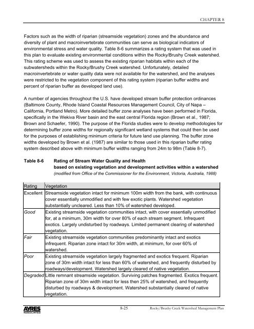
CHAPTER 8Factors such as the width of riparian (streamside vegetation) zones and the abundance anddiversity of plant and macroinvertebrate communities can serve as biological indicators ofenvironmental stress and water quality. Table 8-6 summarizes a rating system that was used inthis plan to evaluate existing environmental conditions within the <strong>Rocky</strong>/<strong>Brushy</strong> <strong>Creek</strong> watershed.This rating scheme was used to assess the existing riparian habitats within each of thesubwatersheds within the <strong>Rocky</strong>/<strong>Brushy</strong> <strong>Creek</strong> watershed. Unfortunately, detailedmacroinvertebrate or water quality data were not available for the watershed, and the analyseswere restricted to the vegetation component of this rating system (riparian buffer widths andpercent of riparian buffer as developed land use).A number of agencies throughout the U.S. have developed stream buffer protection ordinances(Baltimore County, Rhode Island Coastal Resources Management Council, City of Napa –California, Portland Metro). More detailed buffer zone analyses have been performed in Florida,specifically in the Wekiva River basin and the east central Florida region (Brown et al., 1987;Brown and Schaefer, 1990). The purpose of the Florida studies were to develop methodologies fordetermining buffer zone widths for regionally significant wetland systems that could then be usedfor the purposes of establishing minimum criteria for future land use planning. The buffer zonewidths developed by Brown et al. (1987) are similar to those used in this riparian buffer ratingsystem described above with minimum buffer widths ranging from 24m to 98m (Table 8-7).Table 8-6Rating of Stream Water Quality and Healthbased on existing vegetation and development activities within a watershed(modified from Office of the Commissioner for the Environment, Victoria, Australia, 1988)Rating VegetationExcellent Streamside vegetation intact for minimum 100m width from the bank, with continuouscover essentially unmodified and with few exotic plants. <strong>Watershed</strong> vegetationsubstantially uncleared. Less than 10% of watershed developed.Good Existing streamside vegetation communities intact, with cover essentially unmodifiedfor, at a minimum, 30m width for over 80% of each stream segment. Infrequentexotics. Largely undisturbed by roadways. Limited permanent clearing of watershedvegetation.Fair Existing streamside vegetation communities predominantly intact and exoticsinfrequent. Riparian zone intact for 30m width, at minimum, for over 60% ofwatershed.Poor Existing streamside vegetation largely fragmented and exotics frequent. Riparianzone of 30m width intact for less than 60% of watershed, and frequently disturbed byroadways/development. <strong>Watershed</strong> largely cleared of native vegetation.Degraded Little remnant streamside vegetation. Surviving patches fragmented. Exotics frequent.Riparian zone of 30m width intact for less then 25% of watershed, and frequentlydisturbed by roadways & development. <strong>Watershed</strong> substantially cleared of nativevegetation.8-25<strong>Rocky</strong>/<strong>Brushy</strong> <strong>Creek</strong> <strong>Watershed</strong> Management <strong>Plan</strong>


